Blackstump Creek

Sea, Estuary, Creek in Kent Swale

England

Blackstump Creek

Saltflats emerging from the ebbing tide The spring tide was at its highest about an hour before I took this shot but these grassy salt flats are normally visible at all states of the tide. The water beyond is Long Reach in the Swale and the far shore is Rushenden Marsh. This is the furthest north one can go on a public footpath on the Chetney peninsula, the Saxon Shore Way turns west here.
Saltflats emerging from the ebbing tide Credit: Penny Mayes

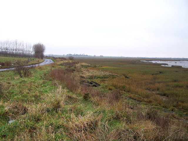
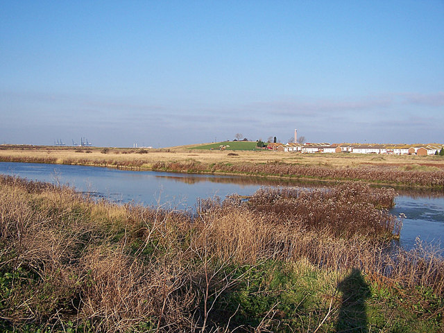
Blackstump Creek is a picturesque water body located in the county of Kent, England. It is known for its diverse ecosystem and its significance as both a sea and estuary creek. Spanning approximately 3 miles in length, it is situated near the coastal town of Blackstump and flows into the North Sea.

The creek is characterized by its brackish water, which is a mixture of saltwater and freshwater. This unique blend creates an ideal environment for a wide variety of flora and fauna to thrive. The surrounding area is rich in marshes, wetlands, and mudflats, which serve as habitats for numerous species of birds, fish, and other aquatic creatures.

Blackstump Creek is particularly popular among birdwatchers, as it attracts migratory birds during different seasons. Visitors can spot elegant wading birds such as herons, egrets, and curlews, along with seabirds like gulls and terns. The creek also supports a vibrant population of fish, including flounders, eels, and various species of sea bass.

In addition to its ecological significance, Blackstump Creek offers recreational opportunities for both locals and tourists. It is a favored spot for fishing enthusiasts, who often gather along its banks to cast their lines. Boating and kayaking are also popular activities, allowing visitors to explore the scenic waterway and its surrounding natural beauty.

Overall, Blackstump Creek in Kent is a stunning and biodiverse water body, offering a serene escape for nature lovers and providing a vital habitat for a range of wildlife.

If you have any feedback on the listing, please let us know in the comments section below.

Blackstump Creek Images

Images are sourced within 2km of 51.401675/0.69828677 or Grid Reference TQ8770. Thanks to Geograph Open Source API. All images are credited.

Saltflats emerging from the ebbing tide The spring tide was at its highest about an hour before I took this shot but these grassy salt flats are normally visible at all states of the tide. The water beyond is Long Reach in the Swale and the far shore is Rushenden Marsh. This is the furthest north one can go on a public footpath on the Chetney peninsula, the Saxon Shore Way turns west here.
Saltflats emerging from the ebbing tide
The spring tide was at its highest about an hour before I took this shot but these grassy salt flats are normally visible at all states of the tide. The water beyond is Long Reach in the Swale and the far shore is Rushenden Marsh. This is the furthest north one can go on a public footpath on the Chetney peninsula, the Saxon Shore Way turns west here.
Pylon on Chetney Marsh The pylons march north across the marsh to take power across the Medway at <a href="https://www.geograph.org.uk/photo/39424">TQ8772 : Medway Cable Tunnel South Pylon</a>. The body of water pictured here looks, from the map, to have been a tidal creek before the sea wall was built.
Pylon on Chetney Marsh
The pylons march north across the marsh to take power across the Medway at TQ8772 : Medway Cable Tunnel South Pylon. The body of water pictured here looks, from the map, to have been a tidal creek before the sea wall was built.
Chetney Marshes Taken from the sea wall beside the Swale. The meandering dyke, shown by the line of brown reeds, must have carved its own channel as drainage dykes are usually straight. The group of men on the raised track just right of centre are a shooting party, presumably after wild fowl, the large flock of Canada geese <a title="https://www.geograph.org.uk/photo/255402" href="https://www.geograph.org.uk/photo/255402">Link</a> was keeping out of their way but didn't seem particularly bothered about them.
The pylons are taking power across the Medway via the cable tunnel. Clear visibility and the low lying land disguise the fact that the oil refinery on the right and Thamesport, obscured by the pylons, are in fact about 10 kilometres away across the River Medway on the Isle of Grain.
Chetney Marshes
Taken from the sea wall beside the Swale. The meandering dyke, shown by the line of brown reeds, must have carved its own channel as drainage dykes are usually straight. The group of men on the raised track just right of centre are a shooting party, presumably after wild fowl, the large flock of Canada geese Link was keeping out of their way but didn't seem particularly bothered about them. The pylons are taking power across the Medway via the cable tunnel. Clear visibility and the low lying land disguise the fact that the oil refinery on the right and Thamesport, obscured by the pylons, are in fact about 10 kilometres away across the River Medway on the Isle of Grain.
Chetney Marsh The sea wall north of the Saxon Shore Way (no public access - for the protection of wildfowl). The map shows a lot more low-lying marsh between here and the Isle of Grain power station seen in the background but the high spring tide has swamped it. The small hump of land on the right is on the Isle of Sheppey near Rushenden.
Chetney Marsh
The sea wall north of the Saxon Shore Way (no public access - for the protection of wildfowl). The map shows a lot more low-lying marsh between here and the Isle of Grain power station seen in the background but the high spring tide has swamped it. The small hump of land on the right is on the Isle of Sheppey near Rushenden.
Shooting party on Chetney Marsh Moving off to try their luck on another part of the marsh.
Shooting party on Chetney Marsh
Moving off to try their luck on another part of the marsh.
Causeway and dyke, Chetney Marsh The causeway carries the Saxon Shore Way which does not follow the shoreline right round the northern end of the peninsula but cuts across to the Old Counter Wall (an earlier sea wall) instead.
Causeway and dyke, Chetney Marsh
The causeway carries the Saxon Shore Way which does not follow the shoreline right round the northern end of the peninsula but cuts across to the Old Counter Wall (an earlier sea wall) instead.
The importance of the sea wall The full moon soon after the equinox brings a very high spring tide. Fortunately it has no wind behind it and the sea wall is doing its job, protecting the coastal grazing marshes on the right; an important habitat for wildlife and flora. Parts of Chetney Marshes have been returned to grazing from arable in order to replace similar land lost to the improved A249 and new Sheppey Bridge (seen in the background).
The importance of the sea wall
The full moon soon after the equinox brings a very high spring tide. Fortunately it has no wind behind it and the sea wall is doing its job, protecting the coastal grazing marshes on the right; an important habitat for wildlife and flora. Parts of Chetney Marshes have been returned to grazing from arable in order to replace similar land lost to the improved A249 and new Sheppey Bridge (seen in the background).
We have lift off! Swans taking off from a lagoon on Chetney Marsh. I think these are the common mute swans but Bewicks have been seen hereabouts. Chetney Marsh is an important habitat for wildlife and flora.
We have lift off!
Swans taking off from a lagoon on Chetney Marsh. I think these are the common mute swans but Bewicks have been seen hereabouts. Chetney Marsh is an important habitat for wildlife and flora.
Tiny mushrooms Growing on the sea wall. You may judge their size by comparing with the rabbit droppings.
Tiny mushrooms
Growing on the sea wall. You may judge their size by comparing with the rabbit droppings.
Farm Track on Chetney Marsh On the skyline is Grain Power Station and Thamesport Container Terminal
Farm Track on Chetney Marsh
On the skyline is Grain Power Station and Thamesport Container Terminal
Drainage Channel on Chetney Marsh Grain Power Station and Thamesport Container Terminal are visible on the horizon.
Drainage Channel on Chetney Marsh
Grain Power Station and Thamesport Container Terminal are visible on the horizon.
Farm Track on Chetney Marsh Looking North East towards the Isle of Sheppey. The marsh is a bird reserve. If you visit here, please take care not to disturb the birds, and keep dogs on leads.
Farm Track on Chetney Marsh
Looking North East towards the Isle of Sheppey. The marsh is a bird reserve. If you visit here, please take care not to disturb the birds, and keep dogs on leads.
Saxon Shore Way, Chetney Marsh This is the point where the Saxon Shore Way (the green path) crosses a tarmac farm track (which is marked as a Byway on the OS map). The Marsh is a bird reserve. If you visit here, please take care not to disturb the birds and keep dogs on leads at all times.
Saxon Shore Way, Chetney Marsh
This is the point where the Saxon Shore Way (the green path) crosses a tarmac farm track (which is marked as a Byway on the OS map). The Marsh is a bird reserve. If you visit here, please take care not to disturb the birds and keep dogs on leads at all times.
Earthbank dividing Chetney and Tailness Marshes Also seen in background is Kingsnorth Power Station.
Earthbank dividing Chetney and Tailness Marshes
Also seen in background is Kingsnorth Power Station.
Saxon Shore Way sign in Chetney Marshes The Saxon Shore Way in the area follows the coast around the marshes.
The new A249 Sheppey bridge is in the background.
Saxon Shore Way sign in Chetney Marshes
The Saxon Shore Way in the area follows the coast around the marshes. The new A249 Sheppey bridge is in the background.
Saltings near Tailness Marshes Looking towards Long Reach section of The Swale.
Swale Bridge in background.
Saltings near Tailness Marshes
Looking towards Long Reach section of The Swale. Swale Bridge in background.
Chetney Marsh - end of the public footpath At the time of writing (9 Apr 2009) there are 4 "green" squares on Chetney Marsh that can't be visited without disobeying this notice!
Chetney Marsh - end of the public footpath
At the time of writing (9 Apr 2009) there are 4 "green" squares on Chetney Marsh that can't be visited without disobeying this notice!
Part of the Chetney Marshes
Show me another place!

Blackstump Creek is located at Grid Ref: TQ8770 (Lat: 51.401675, Lng: 0.69828677)

Administrative County: Kent

District: Swale

Police Authority: Kent

What 3 Words

///refusals.foreheads.mixed. Near Iwade, Kent

Related Wikis

Chetney Hill

Chetney Hill was a planned lazaret on the banks of the River Medway estuary in Kent. Inspired by European ports such as Marseille and Venice, it was intended...
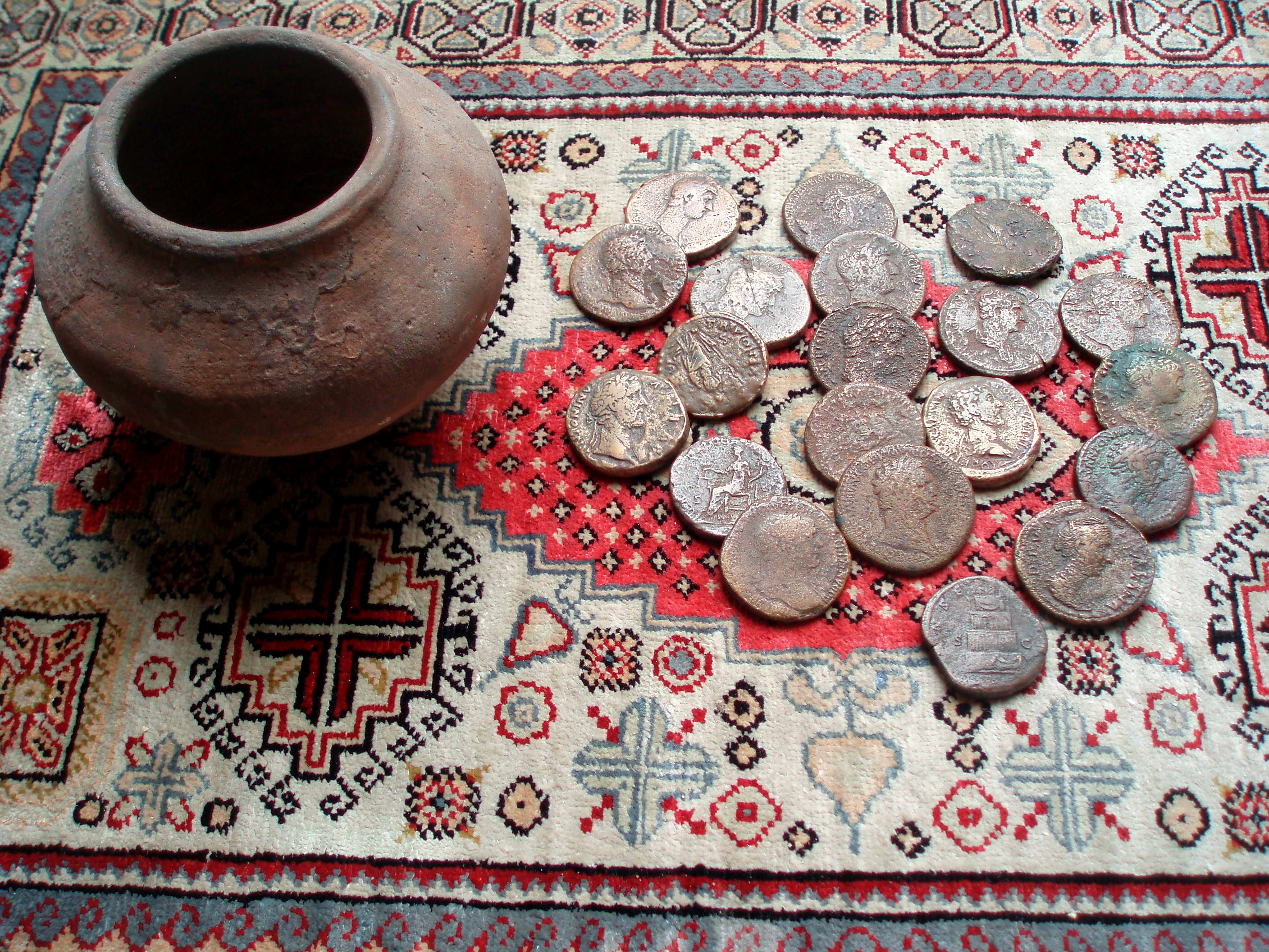
Upchurch Hoard

The Upchurch Hoard was a pot containing thirty-seven Roman sestertii dating from the late 1st century to the second half of the 2nd century AD found near...

Funton

Funton is a location in Kent, United Kingdom. It is a creek situated on the edge of the North Kent Marshes on the right bank of the River Medway about...

Burntwick Island

Burntwick Island is an island in the estuary of the River Medway in Kent, United Kingdom. It is a flat, raised area of marshland around 2 kilometres (1...

Deadman's Island (Kent)

Deadman's Island is a small island in the estuary of the River Medway in Kent, United Kingdom close to where The Swale flows into the Medway. It is a flat...

Medway Estuary and Marshes

Medway Estuary and Marshes is a 4,748.8-hectare (11,735-acre) biological Site of Special Scientific Interest which stretches along the banks of the River...

Queenborough-in-Sheppey

Queenborough-in-Sheppey was a municipal borough in Kent, England from 1968 to 1974. It was created by a merger of the Municipal Borough of Queenborough...

Rushenden

Rushenden is a village on the Isle of Sheppey in the Borough of Swale in Kent, England, of approximately 500 dwellings. It lies to the south of Queenborough...

Nearby Amenities

Located within 500m of 51.401675,0.69828677
The data included in this document is from www.openstreetmap.org. The data is made available under ODbL.

Have you been to Blackstump Creek?

Leave your review of Blackstump Creek below (or comments, questions and feedback).