Welland Outfall

Sea, Estuary, Creek in Lincolnshire

England

Welland Outfall

Close up of the training wall The training wall runs either side of the River Welland, with occasional breaks to the drainage system and numerous creek inlets.  Navigation poles line the route as it is difficult to discern the wall when it is below sea level.  Behind the wall lies Herring Hill.  Compare with the photo referred to below.

Having previously attempted a geograph of this gridsquare almost 12 years ago from the Boston Belle <a href="https://www.geograph.org.uk/photo/1494200">TF3937 : Edge of the marsh</a>, I finally managed to photograph it at a much lower level of tide, from Bluey Due which being much smaller than the Boston Belle, could sail much closer to the wall itself.  See link for youTube excerpts of the trip <span class="nowrap"><a title="https://www.youtube.com/watch?v=GLveWvAEe-w" rel="nofollow ugc noopener" href="https://www.youtube.com/watch?v=GLveWvAEe-w">Link</a><img style="margin-left:2px;" alt="External link" title="External link - shift click to open in new window" src="https://s1.geograph.org.uk/img/external.png" width="10" height="10"/></span>.
Close up of the training wall Credit: Ian Paterson

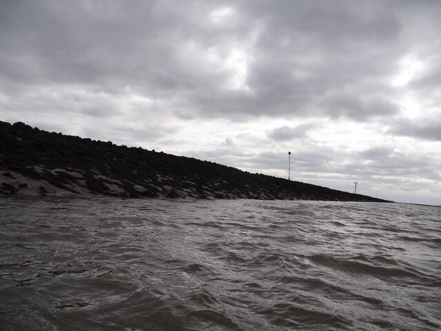
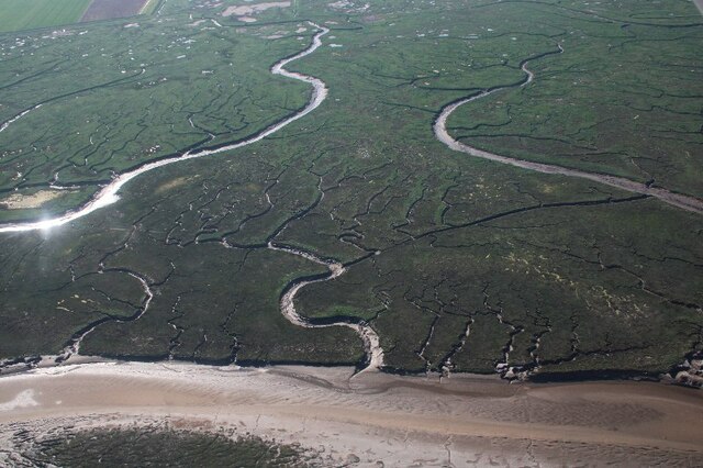
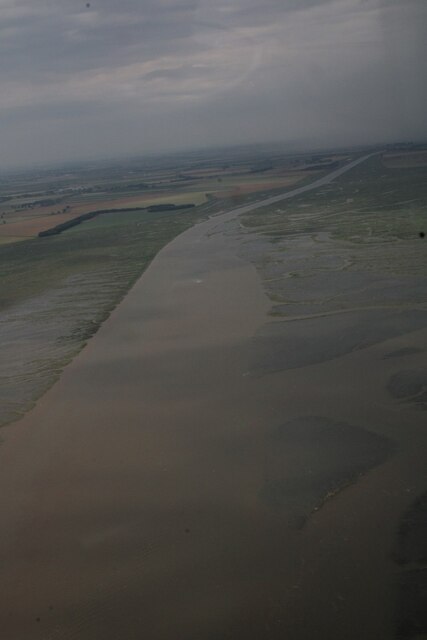
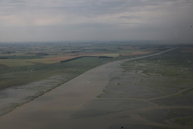
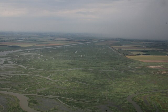
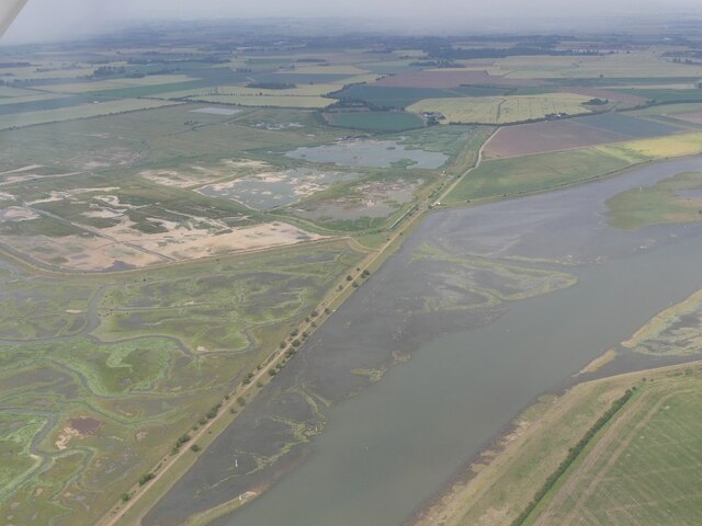
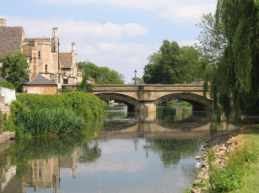
The Welland Outfall is a prominent geographical feature located in Lincolnshire, England. It serves as the drainage point for the River Welland, which flows into the North Sea. The outfall is situated at the mouth of the river, where it meets the sea, estuary, and creek.

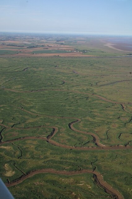
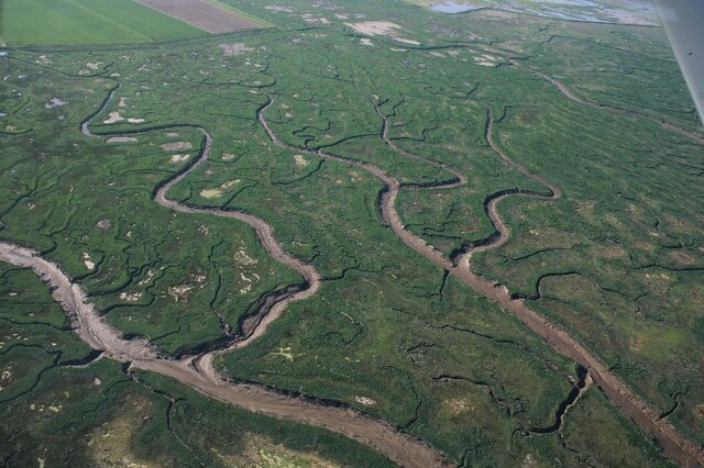
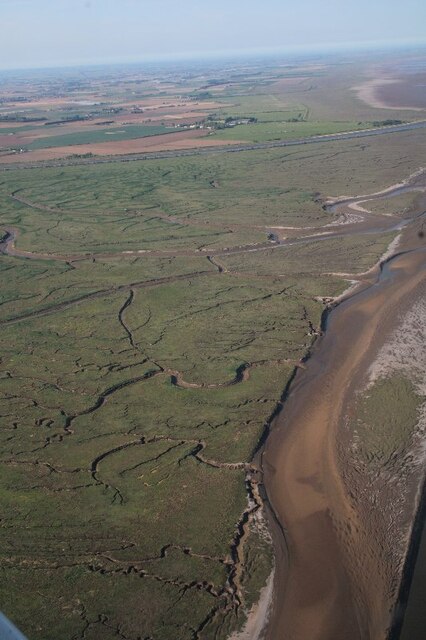
The Welland Outfall is a vital component of the region's water management system, serving to regulate the flow of water from the river and prevent flooding in the surrounding areas. It plays a crucial role in maintaining the ecological balance of the region and protecting the local habitats.

The outfall is characterized by its large concrete structure, designed to withstand the forces of the sea and efficiently channel the water. It is equipped with gates and sluices that can be adjusted to control the water levels and prevent high tides from inundating the land. These gates also facilitate the passage of ships into the river, making the Welland Outfall an important navigational point.

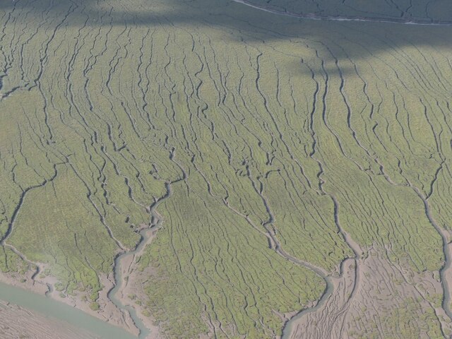
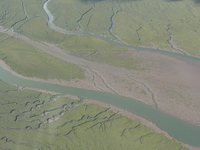
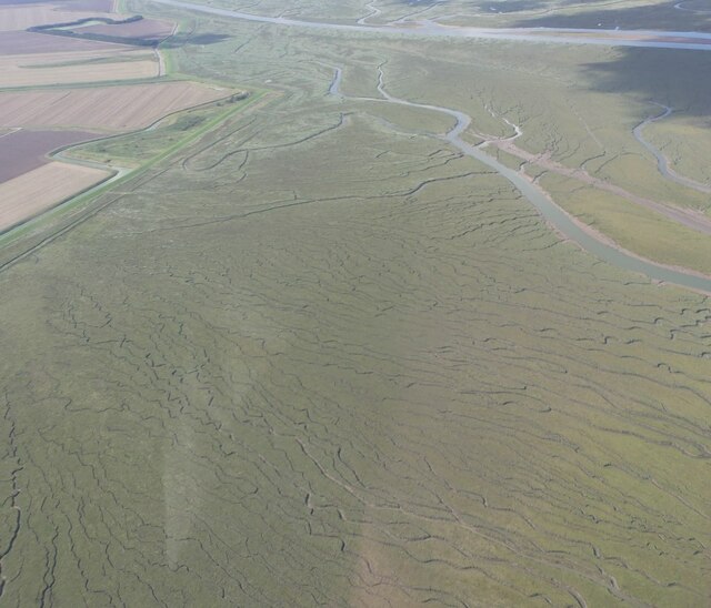
The estuary formed by the Welland Outfall provides an ideal habitat for various species of birds, fish, and other marine life. It is a popular spot for birdwatching and attracts enthusiasts from all over the country. The creek, on the other hand, offers a tranquil environment for recreational activities such as boating and fishing.

Overall, the Welland Outfall in Lincolnshire serves as a crucial link between the River Welland and the North Sea, ensuring effective water management and providing a diverse range of ecological and recreational opportunities.

If you have any feedback on the listing, please let us know in the comments section below.

Welland Outfall Images

Images are sourced within 2km of 52.912867/0.052567808 or Grid Reference TF3837. Thanks to Geograph Open Source API. All images are credited.

Close up of the training wall The training wall runs either side of the River Welland, with occasional breaks to the drainage system and numerous creek inlets.  Navigation poles line the route as it is difficult to discern the wall when it is below sea level.  Behind the wall lies Herring Hill.  Compare with the photo referred to below.

Having previously attempted a geograph of this gridsquare almost 12 years ago from the Boston Belle <a href="https://www.geograph.org.uk/photo/1494200">TF3937 : Edge of the marsh</a>, I finally managed to photograph it at a much lower level of tide, from Bluey Due which being much smaller than the Boston Belle, could sail much closer to the wall itself.  See link for youTube excerpts of the trip <span class="nowrap"><a title="https://www.youtube.com/watch?v=GLveWvAEe-w" rel="nofollow ugc noopener" href="https://www.youtube.com/watch?v=GLveWvAEe-w">Link</a><img style="margin-left:2px;" alt="External link" title="External link - shift click to open in new window" src="https://s1.geograph.org.uk/img/external.png" width="10" height="10"/></span>.
Close up of the training wall
The training wall runs either side of the River Welland, with occasional breaks to the drainage system and numerous creek inlets. Navigation poles line the route as it is difficult to discern the wall when it is below sea level. Behind the wall lies Herring Hill. Compare with the photo referred to below. Having previously attempted a geograph of this gridsquare almost 12 years ago from the Boston Belle TF3937 : Edge of the marsh, I finally managed to photograph it at a much lower level of tide, from Bluey Due which being much smaller than the Boston Belle, could sail much closer to the wall itself. See link for youTube excerpts of the trip LinkExternal link.
Salt marsh, Frampton
The Cots, salt marsh in the Frampton Nature Reserve by the Welland outfall: aerial 2023
Western Point in the Rampton Nature Reserve by the Welland outfall: aerial 2023 (1)
River Welland and salt marsh, Frampton Naure Reserve: aerial 2023
Western Point in the Rampton Nature Reserve by the Welland outfall: aerial 2023 (2)
River Welland Outfall: aerial 2023 (1)
River Welland Outfall: aerial 2023 (2)
River Welland Outfall and saltmarsh: aerial 2023 The Scalp and the Cots.
River Welland Outfall and saltmarsh: aerial 2023
The Scalp and the Cots.
Haven (River Witham) to Frampton Marsh: aerial 2023 Two storm cells visible across the top of the shot. It was time to go home!
Haven (River Witham) to Frampton Marsh: aerial 2023
Two storm cells visible across the top of the shot. It was time to go home!
Welland Outfall and the Scalp (marsh): aerial 2023 (1)
Haven and Welland Outfall, and the Scalp (marsh): aerial 2023 (1)
Saltmarsh south of Welland Outfall: aerial 2023 (1)
Saltmarsh south of Welland Outfall: aerial 2023 (2)
Saltmarsh south of Welland Outfall: aerial 2023 (3)
Bridleway junction Bridleway from the south approaching the main Sea Bank bridleway near Fosdyke Wash
Bridleway junction
Bridleway from the south approaching the main Sea Bank bridleway near Fosdyke Wash
Sea Bank bridleway Marshland of The Wash is on the right. The beauty of this area - utterly devoid of any topographic feature - is difficult to capture on camera.
Sea Bank bridleway
Marshland of The Wash is on the right. The beauty of this area - utterly devoid of any topographic feature - is difficult to capture on camera.
River Welland Estuary The outfall of the River Welland into the Wash. There are piles of rocks called training walls to direct the flow of the river so that it keeps the channel clear they are marked by the perches or poles either side.
River Welland Estuary
The outfall of the River Welland into the Wash. There are piles of rocks called training walls to direct the flow of the river so that it keeps the channel clear they are marked by the perches or poles either side.
Show me another place!

Welland Outfall is located at Grid Ref: TF3837 (Lat: 52.912867, Lng: 0.052567808)

Administrative County: Lincolnshire

Police Authority: Lincolnshire

What 3 Words

///villas.sparrows.paramedic. Near Fishtoft, Lincolnshire

Related Wikis

River Welland

The River Welland is a lowland river in the east of England, some 65 miles (105 km) long. It drains part of the Midlands eastwards to The Wash. The river...

RSPB Frampton Marsh

Frampton Marsh is a nature reserve in Lincolnshire, England. The reserve is situated on the coast of The Wash, some 4 miles from the town of Boston, between...

HM Prison North Sea Camp

HM Prison North Sea Camp is a men's open prison (Category D), located on the edge of the parish of Freiston (near Boston) in Lincolnshire, England. North...

Pilgrim Fathers Memorial

The Pilgrim Fathers Memorial is located on the north bank of The Haven at the site of the former Scotia Creek, Fishtoft, seaward of Boston in Lincolnshire...

Holbeach St Matthew

Holbeach St Matthew is a small fenland village in the South Holland district of southern Lincolnshire, England. It lies 6 miles (10 km) north-east from...

Boston Rural District

Boston was a rural district in Holland, Lincolnshire from 1894 to 1974. It was formed from the Boston rural sanitary district by the Local Government Act...

Fishtoft

Fishtoft is one of eighteen civil parishes which, together with Boston, form the Borough of Boston in the county of Lincolnshire, England. Local government...

Freiston Shore

Freiston Shore is a settlement in the Borough of Boston, in Lincolnshire, England. It is in the civil parish of Freiston, and approximately 4 miles (6...

Nearby Amenities

Located within 500m of 52.912867,0.052567808
Man Made: beacon
Lat/Long: 52.9159063/0.0564714
The data included in this document is from www.openstreetmap.org. The data is made available under ODbL.

Have you been to Welland Outfall?

Leave your review of Welland Outfall below (or comments, questions and feedback).