Caolas nan Gall

Sea, Estuary, Creek in Argyllshire

Scotland

Caolas nan Gall

Memorial to Lieutenant David Lowe Macintyre David Lowe Macintyre VC, CB (18 June 1895 – 31 July 1967) was a Scottish recipient of the Victoria Cross.
Memorial to Lieutenant David Lowe Macintyre Credit: Andrew Abbott

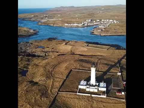
Caolas nan Gall is a picturesque sea inlet located in Argyllshire, Scotland. Nestled between dramatic rocky cliffs and rolling hills, this estuary offers breathtaking views and a tranquil atmosphere.

The caolas, or narrow sea channel, is formed by the confluence of two smaller creeks, creating a natural harbor for local fishing boats and pleasure craft. The crystal-clear waters are a haven for marine life, attracting a variety of fish, seals, and seabirds. Visitors can often spot otters playing along the shoreline or dolphins frolicking in the distance.

Surrounded by lush vegetation and diverse wildlife, Caolas nan Gall is a haven for nature enthusiasts. The area is home to numerous species of birds, including herons, oystercatchers, and cormorants, making it a popular spot for birdwatching. The rugged coastline and surrounding hills also offer excellent opportunities for hiking and exploring the unspoiled wilderness.

Caolas nan Gall is not only a natural paradise but also holds historical significance. The remains of ancient settlements, including Viking ruins, can be found along the shoreline, providing glimpses into the area's rich cultural heritage. Visitors can explore these historical sites and imagine what life was like in centuries past.

Whether you prefer a leisurely stroll along the beach, an adventurous hike, or simply taking in the stunning vistas, Caolas nan Gall offers a truly unforgettable experience. Its natural beauty, wildlife, and historical significance make it an idyllic destination for nature lovers and history enthusiasts alike.

If you have any feedback on the listing, please let us know in the comments section below.

Caolas nan Gall Images

Images are sourced within 2km of 55.677274/-6.5154187 or Grid Reference NR1651. Thanks to Geograph Open Source API. All images are credited.

Memorial to Lieutenant David Lowe Macintyre David Lowe Macintyre VC, CB (18 June 1895 – 31 July 1967) was a Scottish recipient of the Victoria Cross.
Memorial to Lieutenant David Lowe Macintyre
David Lowe Macintyre VC, CB (18 June 1895 – 31 July 1967) was a Scottish recipient of the Victoria Cross.
Rocks at An Dubh-laoig
Rubbish tip
Rubbish tip
Boat under repair
Boat under repair
Main Street, Port Wemyss/Bun Othan
Caolas na Cor-sgeire
Coast at Claddach
Coast at Claddach
Main Street, Port Wemyss/Bun Othan
Village Hall
Village Hall
Coastal views from holiday cottage
Portnahaven
Portnahaven
Views out to sea Portnahaven
Portnahaven, Parish Church
OS Cut Mark - Portnahaven, Parish Church <span class="nowrap"><a title="https://www.bench-marks.org.uk/bm58120" rel="nofollow ugc noopener" href="https://www.bench-marks.org.uk/bm58120">Link</a><img style="margin-left:2px;" alt="External link" title="External link - shift click to open in new window" src="https://s1.geograph.org.uk/img/external.png" width="10" height="10"/></span>
OS Cut Mark - Portnahaven, Parish Church
View to Orsay from Port Wemyss
Former Portnahaven Coast Guard Lookout
Portnahaven
Portnahaven
Former school, Portnahaven Now a holiday let.
Former school, Portnahaven
Now a holiday let.
Show me another place!

Caolas nan Gall is located at Grid Ref: NR1651 (Lat: 55.677274, Lng: -6.5154187)

Unitary Authority: Argyll and Bute

Police Authority: Argyll and West Dunbartonshire

What 3 Words

///villager.certified.airship. Near Portnahaven, Argyll & Bute

Related Wikis

Eilean Mhic Coinnich

Eilean Mhic Coinnich, also known as Mackenzie Island (although recorded on the Land Register as McKenseys Island), is an uninhabited island of 17.3 hectares...

Orsay, Inner Hebrides

Orsay (Scottish Gaelic: Orasaigh) is a small island in the Inner Hebrides of Scotland. It lies a short distance off the west coast of the island of Islay...

Portnahaven

Portnahaven (Scottish Gaelic: Port na h-Abhainne, meaning river port) is a village on Islay in the Inner Hebrides, Scotland. The village is within the...

Islay LIMPET

Islay LIMPET was the world's first commercial wave power device and was connected to the United Kingdom's National Grid. == History == Islay LIMPET (Land...

Rhinns complex

The Rhinns complex is a deformed Palaeoproterozoic igneous complex that is considered to form the basement to the Colonsay Group of metasedimentary rocks...

Easter Ellister

Easter Ellister (Aolastradh) is a settlement on the Rinns of Islay on Islay in the Inner Hebrides of Scotland. It lies just off the A847 road between Portnahaven...

Nerabus

Nerabus (otherwise Nereabolls) is a hamlet in the west of the isle of Islay in Scotland. The vicinity is noted for its scenic qualities and diverse birdlife...

Rinns of Islay

The Rinns of Islay (Scottish Gaelic: Na Roinn Ìleach; alternative English spelling Rhinns of Islay) is an area on the west of the island of Islay in the...

Related Videos

Portnahaven Sunset

Islay festival week 2019.

MAIRI’S WEDDING Live On BAGPIPES | Portnahaven Islay

PipingBairn performs a live solo bagpipe cover of Mairi's Wedding also known as the Lewis Bridal Song (composed by John ...

Orsay House Islay

Orsay Lighthouse to Portnahaven Islay. Orsay House B&B. Orsayhouse.co.uk.

Nearby Amenities

Located within 500m of 55.677274,-6.5154187
Created By: dmgroom_coastlines
Source: PGS
Lat/Long: 55.67761/-6.51407
Created By: dmgroom_coastlines
Source: PGS
Lat/Long: 55.67776/-6.51542
Created By: dmgroom_coastlines
Source: PGS
Lat/Long: 55.67777/-6.51587
Created By: dmgroom_coastlines
Source: PGS
Lat/Long: 55.67778/-6.51633
Created By: dmgroom_coastlines
Source: PGS
Lat/Long: 55.67791/-6.51655
Created By: dmgroom_coastlines
Source: PGS
Lat/Long: 55.67817/-6.51653
Created By: dmgroom_coastlines
Source: PGS
Lat/Long: 55.67842/-6.51629
Created By: dmgroom_coastlines
Source: PGS
Lat/Long: 55.67844/-6.51719
Created By: dmgroom_coastlines
Source: PGS
Lat/Long: 55.67895/-6.51739
Created By: dmgroom_coastlines
Source: PGS
Lat/Long: 55.67948/-6.51781
Created By: dmgroom_coastlines
Source: PGS
Lat/Long: 55.67961/-6.51802
Created By: dmgroom_coastlines
Source: PGS
Lat/Long: 55.67962/-6.51848
Created By: dmgroom_coastlines
Source: PGS
Lat/Long: 55.6795/-6.51894
Created By: dmgroom_coastlines
Source: PGS
Lat/Long: 55.68001/-6.51913
Created By: dmgroom_coastlines
Source: PGS
Lat/Long: 55.68015/-6.51935
Created By: dmgroom_coastlines
Source: PGS
Lat/Long: 55.68042/-6.52024
Created By: dmgroom_coastlines
Source: PGS
Lat/Long: 55.68055/-6.52046
Created By: dmgroom_coastlines
Source: PGS
Lat/Long: 55.68125/-6.51656
Created By: dmgroom_coastlines
Source: PGS
Lat/Long: 55.68136/-6.5161
Created By: dmgroom_coastlines
Source: PGS
Lat/Long: 55.68135/-6.51565
Created By: dmgroom_coastlines
Source: PGS
Lat/Long: 55.68121/-6.51475
Created By: dmgroom_coastlines
Source: PGS
Lat/Long: 55.68096/-6.51499
Created By: dmgroom_coastlines
Source: PGS
Lat/Long: 55.6807/-6.51501
Created By: dmgroom_coastlines
Source: PGS
Lat/Long: 55.68043/-6.51457
Created By: dmgroom_coastlines
Source: PGS
Lat/Long: 55.6794/-6.51418
Created By: dmgroom_coastlines
Source: PGS
Lat/Long: 55.67915/-6.5142
Created By: dmgroom_coastlines
Source: PGS
Lat/Long: 55.67889/-6.51422
Created By: dmgroom_coastlines
Source: PGS
Lat/Long: 55.67837/-6.5138
Created By: dmgroom_coastlines
Source: PGS
Lat/Long: 55.67811/-6.51381
Source: PGS
Lat/Long: 55.6751948/-6.51637
Created By: dmgroom_coastlines
Source: PGS
Lat/Long: 55.67642/-6.51233
Pub
An Tigh Seinnse
Addr Country: GB
Addr Postcode: PA47 7SJ
Addr Street: Queen Street
Fhrs Id: 33472
Opening Hours: Mo-Su 12:00-23:00
Opening Hours Kitchen: Fr-Tu 12:00-18:00; We-Th 12:00-16:00
Tourism: guest_house
Wheelchair: no
Lat/Long: 55.6801455/-6.509529
Rinns of Islay Lighthouse
Man Made: lighthouse
Seamark Light 1 Character: Fl
Seamark Light 1 Colour: white
Seamark Light 1 Height: 46
Seamark Light 1 Period: 5
Seamark Light 1 Range: 24
Seamark Light 1 Sector End: 184
Seamark Light 1 Sector Start: 256
Seamark Light 1 Sequence: 0.2+(4.8)
Seamark Light Reference: A 4256
Seamark Name: Rhinns of Islay
Seamark Type: light_major
Wikidata: Q2148102
Lat/Long: 55.6731114/-6.5132529
Orsay Island
Note: Geodetic reference point for UK baseline
Ref: 25
Source: The Territorial Sea (Amendment) Order 1998 (No. 2564)
Lat/Long: 55.6732802/-6.5173617
Bus Stop
Lat/Long: 55.6800095/-6.5094011
Hugh MacKay's Grave
Cemetery: grave
Heritage: yes
Wikidata: Q1634457
Lat/Long: 55.6757106/-6.5124048
Orsay House
Addr City: Portnahaven
Addr Country: GB
Addr Housename: Orsay House
Addr Housenumber: 8
Addr Postcode: PA47 7SJ
Addr Street: Queen Street
Email: orsayhouse@gmail.com
Fhrs Id: 1300458
Guest House: bed_and_breakfast
Internet Access: yes
Rooms: 3
Tourism: guest_house
Website: https://www.orsayhouse.co.uk
Lat/Long: 55.6802537/-6.5098945
Power: pole
Lat/Long: 55.6777709/-6.5075208
Material: wood
Power: pole
Lat/Long: 55.6777832/-6.5081622
Material: wood
Power: pole
Lat/Long: 55.6783729/-6.5078761
Power: pole
Lat/Long: 55.6779703/-6.5077975
Street Lamp
Lat/Long: 55.6802926/-6.5103214
Street Lamp
Lat/Long: 55.6801519/-6.5098836
Street Lamp
Lat/Long: 55.6800204/-6.5094048
The data included in this document is from www.openstreetmap.org. The data is made available under ODbL.

Have you been to Caolas nan Gall?

Leave your review of Caolas nan Gall below (or comments, questions and feedback).