Ladies' Ledge Neck

Sea, Estuary, Creek in Cornwall

England

Ladies' Ledge Neck

A track on eastern St Martin’s The track runs uphill from the eastern end of Higher Town Bay to the Chapel Down and the Daymark.
A track on eastern St Martin’s Credit: David Lally

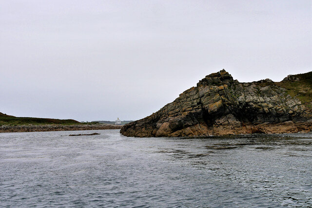
Ladies' Ledge Neck is a scenic coastal area located in Cornwall, England. Situated along the sea, estuary, and creek, this region offers breathtaking views and a variety of natural features.

The sea surrounding Ladies' Ledge Neck is known for its stunning beauty and dramatic cliffs. Visitors can enjoy long walks along the rugged coastline, taking in the sights of crashing waves and picturesque rock formations. The area is a popular spot for birdwatching, with a wide range of seabirds nesting on the cliffs and soaring overhead.

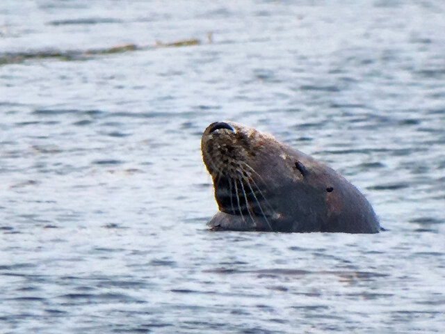
Adjacent to the sea, the estuary at Ladies' Ledge Neck provides a unique ecosystem where saltwater and freshwater mix. This creates a rich habitat for diverse flora and fauna, making it a haven for nature enthusiasts. Visitors can explore the estuary on foot or by boat, observing the various species of marine life and wading birds that call this area home.

Further inland, the creek at Ladies' Ledge Neck offers a tranquil setting for relaxation and exploration. The creek meanders through lush marshes and reed beds, providing a peaceful escape from the bustling coastline. Visitors can kayak or paddleboard along the creek, immersing themselves in the serene surroundings and spotting wildlife such as otters and kingfishers.

Overall, Ladies' Ledge Neck in Cornwall offers a unique blend of coastal beauty, estuarine diversity, and peaceful creek exploration. Whether you are a nature lover, an avid photographer, or simply seeking a peaceful getaway, this area provides a truly unforgettable experience.

If you have any feedback on the listing, please let us know in the comments section below.

Ladies' Ledge Neck Images

Images are sourced within 2km of 49.947019/-6.2614546 or Grid Reference SV9413. Thanks to Geograph Open Source API. All images are credited.

A track on eastern St Martin’s The track runs uphill from the eastern end of Higher Town Bay to the Chapel Down and the Daymark.
A track on eastern St Martin’s
The track runs uphill from the eastern end of Higher Town Bay to the Chapel Down and the Daymark.
St Mary's Harbour Pilot Boat in Crow Sound
Isles of Scilly, Eastern Isles from Crow Sound The large island in the background is St Martin's.
Isles of Scilly, Eastern Isles from Crow Sound
The large island in the background is St Martin's.
Isles of Scilly. Little Ganinick One of the Eastern Isles, a group of twelve small uninhabited islands within the Isles of Scilly Area of Outstanding Natural Beauty. Part of the larger island of Great Ganinick (with more vegetation) can be seen behind (and slightly to the right of) Little Ganinick.
Isles of Scilly. Little Ganinick
One of the Eastern Isles, a group of twelve small uninhabited islands within the Isles of Scilly Area of Outstanding Natural Beauty. Part of the larger island of Great Ganinick (with more vegetation) can be seen behind (and slightly to the right of) Little Ganinick.
Isles of Scilly, Great Arthur Great, Middle and Little Arthur are three of the Eastern Isles, a group of twelve small uninhabited islands within the Isles of Scilly Area of Outstanding Natural Beauty. Great Arthur, as its name suggests, is the largest of the three.
Isles of Scilly, Great Arthur
Great, Middle and Little Arthur are three of the Eastern Isles, a group of twelve small uninhabited islands within the Isles of Scilly Area of Outstanding Natural Beauty. Great Arthur, as its name suggests, is the largest of the three.
Isles of Scilly, Rocky Ledge between Middle and Great Arthur Great, Middle and Little Arthur are three of the Eastern Isles, a group of twelve small uninhabited islands within the Isles of Scilly Area of Outstanding Natural Beauty. Great Arthur, as its name suggests, is the largest of the three.
Isles of Scilly, Rocky Ledge between Middle and Great Arthur
Great, Middle and Little Arthur are three of the Eastern Isles, a group of twelve small uninhabited islands within the Isles of Scilly Area of Outstanding Natural Beauty. Great Arthur, as its name suggests, is the largest of the three.
Isles of Scilly, Middle Arthur Great, Middle and Little Arthur are three of the Eastern Isles, a group of twelve small uninhabited islands within the Isles of Scilly Area of Outstanding Natural Beauty. Great Arthur, as its name suggests, is the largest of the three.
Isles of Scilly, Middle Arthur
Great, Middle and Little Arthur are three of the Eastern Isles, a group of twelve small uninhabited islands within the Isles of Scilly Area of Outstanding Natural Beauty. Great Arthur, as its name suggests, is the largest of the three.
Middle Arthur, Arthur Quay Great, Middle and Little Arthur are three of the Eastern Isles, a group of twelve small uninhabited islands within the Isles of Scilly Area of Outstanding Natural Beauty. Great Arthur, as its name suggests, is the largest of the three.

The three rocky islands are joined by two beaches forming a crescent around Arthur Porth.
Middle Arthur, Arthur Quay
Great, Middle and Little Arthur are three of the Eastern Isles, a group of twelve small uninhabited islands within the Isles of Scilly Area of Outstanding Natural Beauty. Great Arthur, as its name suggests, is the largest of the three. The three rocky islands are joined by two beaches forming a crescent around Arthur Porth.
Rocky Shore, Little Ganilly Little Ganilly (Cornish: Goonhyli Bian, little salt water down) lies just to the north of Little Arthur.
Rocky Shore, Little Ganilly
Little Ganilly (Cornish: Goonhyli Bian, little salt water down) lies just to the north of Little Arthur.
Great Ganilly, West Porth Great Ganilly (Cornish: Goonhyli Meur) is the largest of the Eastern Isles and consists of two hills joined together by a low sandy neck.
Great Ganilly, West Porth
Great Ganilly (Cornish: Goonhyli Meur) is the largest of the Eastern Isles and consists of two hills joined together by a low sandy neck.
Isles of Scilly, Nornour Nornour (Cornish: Ar No) consists of one hill covered in bracken. It lies to the north of Great Ganilly to which it is joined by a boulder causeway at low tide. There is a small area of heath on the hill with heather and bell heather.
Isles of Scilly, Nornour
Nornour (Cornish: Ar No) consists of one hill covered in bracken. It lies to the north of Great Ganilly to which it is joined by a boulder causeway at low tide. There is a small area of heath on the hill with heather and bell heather.
Rocky Ledge between Nornour and Great Ganilly Nornour (Cornish: Ar No) consists of one hill covered in bracken. It is connected to Great Ganilly by a boulder causeway during low tide. The pyramidal island in the background is Hanjague, which is approximately 1 kilometre away.
Rocky Ledge between Nornour and Great Ganilly
Nornour (Cornish: Ar No) consists of one hill covered in bracken. It is connected to Great Ganilly by a boulder causeway during low tide. The pyramidal island in the background is Hanjague, which is approximately 1 kilometre away.
The Eastern Isles, Nornour Nornour (Cornish: Ar No) consists of one hill covered in bracken. It lies to the north of Great Ganilly and is connected to it by a boulder causeway that is visible only during low tide. There is a small area of heath on the hill with heather and bell heather.
The Eastern Isles, Nornour
Nornour (Cornish: Ar No) consists of one hill covered in bracken. It lies to the north of Great Ganilly and is connected to it by a boulder causeway that is visible only during low tide. There is a small area of heath on the hill with heather and bell heather.
Isles of Scilly, Nornour Nornour (Cornish: Ar No) consists of one hill covered in bracken. It lies to the north of Great Ganilly to which it is joined by a boulder causeway at low tide.
Isles of Scilly, Nornour
Nornour (Cornish: Ar No) consists of one hill covered in bracken. It lies to the north of Great Ganilly to which it is joined by a boulder causeway at low tide.
Rocks on the North Coast of Nornour The Eastern Isles (Cornish: Enesow Goonhyli) are a group of twelve small uninhabited islands  located to the south–east of St Martin's. The islands lie within the Isles of Scilly Area of Outstanding Natural Beauty, part of the Scilly Heritage Coast and a Site of Special Scientific Interest (SSSI) first designated in 1971 for its flora and fauna (<span class="nowrap"><a title="https://en.wikipedia.org/wiki/Eastern_Isles" rel="nofollow ugc noopener" href="https://en.wikipedia.org/wiki/Eastern_Isles">Link</a><img style="margin-left:2px;" alt="External link" title="External link - shift click to open in new window" src="https://s1.geograph.org.uk/img/external.png" width="10" height="10"/></span> Wikipedia).
Rocks on the North Coast of Nornour
The Eastern Isles (Cornish: Enesow Goonhyli) are a group of twelve small uninhabited islands located to the south–east of St Martin's. The islands lie within the Isles of Scilly Area of Outstanding Natural Beauty, part of the Scilly Heritage Coast and a Site of Special Scientific Interest (SSSI) first designated in 1971 for its flora and fauna (LinkExternal link Wikipedia).
Isles of Scilly, Nornour The Eastern Isles (Cornish: Enesow Goonhyli) are a group of twelve small uninhabited islands  located to the south–east of St Martin's. The islands lie within the Isles of Scilly Area of Outstanding Natural Beauty, part of the Scilly Heritage Coast and a Site of Special Scientific Interest (SSSI) first designated in 1971 for its flora and fauna (<span class="nowrap"><a title="https://en.wikipedia.org/wiki/Eastern_Isles" rel="nofollow ugc noopener" href="https://en.wikipedia.org/wiki/Eastern_Isles">Link</a><img style="margin-left:2px;" alt="External link" title="External link - shift click to open in new window" src="https://s1.geograph.org.uk/img/external.png" width="10" height="10"/></span> Wikipedia).
Isles of Scilly, Nornour
The Eastern Isles (Cornish: Enesow Goonhyli) are a group of twelve small uninhabited islands located to the south–east of St Martin's. The islands lie within the Isles of Scilly Area of Outstanding Natural Beauty, part of the Scilly Heritage Coast and a Site of Special Scientific Interest (SSSI) first designated in 1971 for its flora and fauna (LinkExternal link Wikipedia).
Isles of Scilly Eastern Isles Looking through the gap between Nornour (on the right) and Great Ganilly.
Isles of Scilly Eastern Isles
Looking through the gap between Nornour (on the right) and Great Ganilly.
Seal Swimming in the Sea off Great Ganilly The Eastern Scilly Isles are one of three main grey seal (Halichoerus grypus) pupping areas.
Seal Swimming in the Sea off Great Ganilly
The Eastern Scilly Isles are one of three main grey seal (Halichoerus grypus) pupping areas.
Show me another place!

Ladies' Ledge Neck is located at Grid Ref: SV9413 (Lat: 49.947019, Lng: -6.2614546)

Division: Isles of Scilly

Unitary Authority: Isles of Scilly

Police Authority: Devon and Cornwall

What 3 Words

///extensive.personal.mailbox. Near St Martin's, Isles of Scilly

Related Wikis

Great Ganilly

Great Ganilly ( gə-NIL-ee; Cornish: Goonhyli Veur, lit. 'great saltwater downs') is one of the Eastern Isles of the Isles of Scilly. It has a maximum total...

Eastern Isles

The Eastern Isles (Cornish: Enesow Goonhyli, islands of the salt water downs) are a group of twelve small uninhabited islands within the Isles of Scilly...

PS Earl of Arran (1860)

PS Earl of Arran was a passenger vessel operated by the Ardrossan Steamboat Company from 1860 to 1871 and the West Cornwall Steam Ship Company from 1871...

Wheel Wreck

The Wheel Wreck is the remains of a shipwreck lying in Crow sound off Little Ganinick in the Isles of Scilly. The wreck site consists of a discrete mound...

Nearby Amenities

Located within 500m of 49.947019,-6.2614546
Eastern Isles
Place: island
Wikidata: Q1278198
Wikipedia: en:Eastern Isles
Lat/Long: 49.9495656/-6.2610838
Arthur Porth
Natural: bay
Source: OS_OpenData_StreetView
Lat/Long: 49.9455723/-6.2645239
Middle Arthur
Place: locality
Source: OS_OpenData_StreetView
Lat/Long: 49.9457654/-6.2668947
Great Arthur
Place: locality
Source: OS_OpenData_StreetView
Lat/Long: 49.9435087/-6.2638278
Ladies' Ledge
Place: locality
Source: OS_OpenData_StreetView
Lat/Long: 49.9475121/-6.2625404
Arthur Quay
Place: locality
Source: OS_OpenData_StreetView
Lat/Long: 49.9469517/-6.2669521
Little Ganilly Neck
Place: locality
Source: OS_OpenData_StreetView
Lat/Long: 49.9479336/-6.2673995
Ladies' Ledge Neck
Place: locality
Source: OS_OpenData_StreetView
Lat/Long: 49.9470984/-6.2614565
Ragged Island
Place: island
Lat/Long: 49.9463119/-6.2579511
Natural: peak
Lat/Long: 49.9434772/-6.2643231
Natural: peak
Lat/Long: 49.9456521/-6.2669731
Frenchman's Rock
Place: islet
Lat/Long: 49.9434804/-6.2612261
West Porth
Natural: bay
Lat/Long: 49.9509187/-6.258246
The data included in this document is from www.openstreetmap.org. The data is made available under ODbL.

Have you been to Ladies' Ledge Neck?

Leave your review of Ladies' Ledge Neck below (or comments, questions and feedback).