Outer Neck of Gerwick

Sea, Estuary, Creek in Cornwall

England

Outer Neck of Gerwick

A misty day on Bryher Not such a good day, weather wise as the mist was down over the island most of the day. This dull view is looking towards Hell Bay Hotel.
A misty day on Bryher Credit: Malcolm Neal

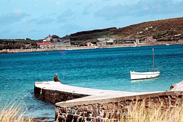
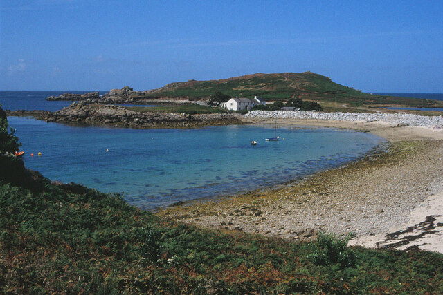
Outer Neck is a scenic coastal area located in Gerwick, Cornwall. Situated on the south-western coast of England, this region offers breathtaking views of the sea, estuary, and creek. With its picturesque landscapes and peaceful ambiance, Outer Neck attracts both locals and tourists alike.

The area is primarily known for its stunning coastline, which stretches for miles. The sea provides a mesmerizing sight, with its crystal-clear waters and gentle waves. Visitors can enjoy leisurely walks along the sandy beaches, taking in the fresh sea air and listening to the soothing sounds of the waves crashing against the shore.

Adjacent to the sea is an estuary, adding to the beauty of Outer Neck. This estuary is a haven for various species of birds, making it a popular spot for birdwatching enthusiasts. The estuary's tranquil waters are also ideal for boating and fishing activities, offering a serene retreat for those seeking relaxation.

In addition to the sea and estuary, Outer Neck is home to a charming creek. This creek meanders through the landscape, providing a tranquil setting for nature lovers. Visitors can explore the creek by foot or opt for a kayak or canoe adventure, immersing themselves in the peaceful surroundings and enjoying the diverse flora and fauna that call the creek home.

Overall, Outer Neck of Gerwick, Cornwall, is a haven for nature enthusiasts and those seeking a peaceful coastal escape. Its combination of sea, estuary, and creek provides a diverse range of activities, from beach walks to birdwatching and boating adventures. Whether it's relaxation or exploration, Outer Neck offers a truly remarkable experience for all.

If you have any feedback on the listing, please let us know in the comments section below.

Outer Neck of Gerwick Images

Images are sourced within 2km of 49.94331/-6.3682123 or Grid Reference SV8613. Thanks to Geograph Open Source API. All images are credited.

A misty day on Bryher Not such a good day, weather wise as the mist was down over the island most of the day. This dull view is looking towards Hell Bay Hotel.
A misty day on Bryher
Not such a good day, weather wise as the mist was down over the island most of the day. This dull view is looking towards Hell Bay Hotel.
Sunset over Samson, Scilly Seen from Star Castle, Hugh Town, St Mary's, Scilly
Sunset over Samson, Scilly
Seen from Star Castle, Hugh Town, St Mary's, Scilly
Queuing on the Quay, Bryher, Scilly This is the original quay, now known as Church Quay to distinguish it from Bar Quay built in 1990. It has since been rebuilt using prefabricated concrete block units, completed c2007. A launch has just arrived - from Tresco.
Queuing on the Quay, Bryher, Scilly
This is the original quay, now known as Church Quay to distinguish it from Bar Quay built in 1990. It has since been rebuilt using prefabricated concrete block units, completed c2007. A launch has just arrived - from Tresco.
Arrival at the Quay, Bryher, Scilly Looking across Quay Beach to what is now known as Church Quay to distinguish it from Bar Quay built in 1990. 
An inter-island ferry boat approaches - there's quite a queue of people waiting for it. In the background is Samson Hill.
Arrival at the Quay, Bryher, Scilly
Looking across Quay Beach to what is now known as Church Quay to distinguish it from Bar Quay built in 1990. An inter-island ferry boat approaches - there's quite a queue of people waiting for it. In the background is Samson Hill.
Fishing off the Quay, Bryher, Scilly Taking advantage of the gap between ferry boats is this angler. Across the water is New Grimsby, Tresco
Fishing off the Quay, Bryher, Scilly
Taking advantage of the gap between ferry boats is this angler. Across the water is New Grimsby, Tresco
The Town, Bryher seen from the church porch, Scilly Behind is Watch Hill.
The Town, Bryher seen from the church porch, Scilly
Behind is Watch Hill.
All Saints’ Church, Bryher, Scilly Built in 1742, rebuilt in 1821-22,  All Saints' is a Grade II  listed building, see: <span class="nowrap"><a title="https://historicengland.org.uk/listing/the-list/list-entry/1141234?section=official-list-entry" rel="nofollow ugc noopener" href="https://historicengland.org.uk/listing/the-list/list-entry/1141234?section=official-list-entry">Link</a><img style="margin-left:2px;" alt="External link" title="External link - shift click to open in new window" src="https://s1.geograph.org.uk/img/external.png" width="10" height="10"/></span>.
In the foreground is a great swath of 'Whistling Jacks' - the wild magenta-coloured gladioli so characteristic of Scilly, see: <span class="nowrap"><a title="http://www.seasonalwildflowers.com/whistling-jacks.html" rel="nofollow ugc noopener" href="http://www.seasonalwildflowers.com/whistling-jacks.html">Link</a><img style="margin-left:2px;" alt="External link" title="External link - shift click to open in new window" src="https://s1.geograph.org.uk/img/external.png" width="10" height="10"/></span>.
All Saints’ Church, Bryher, Scilly
Built in 1742, rebuilt in 1821-22, All Saints' is a Grade II listed building, see: LinkExternal link. In the foreground is a great swath of 'Whistling Jacks' - the wild magenta-coloured gladioli so characteristic of Scilly, see: LinkExternal link.
'Whistling Jacks', Bryher, Scilly The wild magenta-coloured gladioli known locally as 'Whistling Jacks' (but botanically as Gladiolus communis subsp. Byzantium) are very characteristic of Bryher and flower profusely in late spring and early summer. See: <span class="nowrap"><a title="http://www.seasonalwildflowers.com/whistling-jacks.html" rel="nofollow ugc noopener" href="http://www.seasonalwildflowers.com/whistling-jacks.html">Link</a><img style="margin-left:2px;" alt="External link" title="External link - shift click to open in new window" src="https://s1.geograph.org.uk/img/external.png" width="10" height="10"/></span>. Across the water is Abbey Hill, Tresco.
'Whistling Jacks', Bryher, Scilly
The wild magenta-coloured gladioli known locally as 'Whistling Jacks' (but botanically as Gladiolus communis subsp. Byzantium) are very characteristic of Bryher and flower profusely in late spring and early summer. See: LinkExternal link. Across the water is Abbey Hill, Tresco.
The Town, Bryher, from Watch Hill Someone has a bouncy castle. Above it is All Saints' Church <span class="nowrap"><a title="https://historicengland.org.uk/listing/the-list/list-entry/1141234?section=official-list-entry" rel="nofollow ugc noopener" href="https://historicengland.org.uk/listing/the-list/list-entry/1141234?section=official-list-entry">Link</a><img style="margin-left:2px;" alt="External link" title="External link - shift click to open in new window" src="https://s1.geograph.org.uk/img/external.png" width="10" height="10"/></span> . On the left is the landing stage at Church Quay. Beyond Green Bay is Samson Hill, with Samson itself jutting out beyond.
The Town, Bryher, from Watch Hill
Someone has a bouncy castle. Above it is All Saints' Church LinkExternal link . On the left is the landing stage at Church Quay. Beyond Green Bay is Samson Hill, with Samson itself jutting out beyond.
Bryher from Watch Hill Looking right from <a href="https://www.geograph.org.uk/photo/7763670">SV8815 : The Town, Bryher, from Watch Hill</a> across part of The Town towards Bryher's west coast. On the left is Timmy's Hill.
Bryher from Watch Hill
Looking right from SV8815 : The Town, Bryher, from Watch Hill across part of The Town towards Bryher's west coast. On the left is Timmy's Hill.
Shipman Head Well Drang The western coastline of Bryher on Hell Bay below Shipman Head Down. I think the "drang" is the deep cleft on the left. In Orkney and other parts of Britain, this might be called a Geo. The rock partly obscured by high rock piles at the foot of the coastal slope is Great High Rock. The island beyond is Gweal.
Shipman Head Well Drang
The western coastline of Bryher on Hell Bay below Shipman Head Down. I think the "drang" is the deep cleft on the left. In Orkney and other parts of Britain, this might be called a Geo. The rock partly obscured by high rock piles at the foot of the coastal slope is Great High Rock. The island beyond is Gweal.
Great High Rock Rising to 19 metres, so perhaps named a little misleadingly. In the distance, across Hell Bay, is Shipman Head.
Great High Rock
Rising to 19 metres, so perhaps named a little misleadingly. In the distance, across Hell Bay, is Shipman Head.
Popplestone Brow, Bryher Popplestone Brow is the low-lying granite shelf, presumably a wave-cut platform, seen across Popplestone Neck. "It 
reportedly lost 3.5 m in height during the storms of 1989/90 and a further 0.5 m 
in the storms of Easter 1994 ... The 1989 storm eroded 1,000 tonnes of rock from Popplestone Brow" <span class="nowrap"><a title="https://www.scilly.gov.uk/sites/default/files/document/planning/11%20ARUP%20IoS%20Flood%20Defences%20-%20Water%20Interests%20Report%20Defra.pdf" rel="nofollow ugc noopener" href="https://www.scilly.gov.uk/sites/default/files/document/planning/11%20ARUP%20IoS%20Flood%20Defences%20-%20Water%20Interests%20Report%20Defra.pdf">Link</a><img style="margin-left:2px;" alt="External link" title="External link - shift click to open in new window" src="https://s1.geograph.org.uk/img/external.png" width="10" height="10"/></span>. 

Great High Rock is the substantial rock beyond, left of centre. Beyond is Shipman Head.
Popplestone Brow, Bryher
Popplestone Brow is the low-lying granite shelf, presumably a wave-cut platform, seen across Popplestone Neck. "It reportedly lost 3.5 m in height during the storms of 1989/90 and a further 0.5 m in the storms of Easter 1994 ... The 1989 storm eroded 1,000 tonnes of rock from Popplestone Brow" LinkExternal link. Great High Rock is the substantial rock beyond, left of centre. Beyond is Shipman Head.
Great Pool, Bryher Seen from Gweal Hill. Beyond the pool is Hell Bay Hotel. On the extreme left is the beach at Great Popplestones, at the head of Popplestone Neck. The two beaches on the right are Stinking Porth and Great Porth. In the distance are a beach at Appltetree Bay, Tresco and, way beyond, St Mary's.
Great Pool, Bryher
Seen from Gweal Hill. Beyond the pool is Hell Bay Hotel. On the extreme left is the beach at Great Popplestones, at the head of Popplestone Neck. The two beaches on the right are Stinking Porth and Great Porth. In the distance are a beach at Appltetree Bay, Tresco and, way beyond, St Mary's.
Little Crow and Crow Islands, Bryher From Gweal Hill. Oliver Dixon's photo at <a href="https://www.geograph.org.uk/photo/2376222">SV8714 : Headland at Gweal Hill</a> captures these rocks from the low clifftop. Little Crow Island is left of centre; Crow Island is further left. Castle Bryher is prominent above it.
Little Crow and Crow Islands, Bryher
From Gweal Hill. Oliver Dixon's photo at SV8714 : Headland at Gweal Hill captures these rocks from the low clifftop. Little Crow Island is left of centre; Crow Island is further left. Castle Bryher is prominent above it.
Heathy Hill, Bryher A view from Gweak Hill. The peninsula across the centre of the image encloses a bay including Stinking Porth and Great Porth, and contains one of many prehistoric field systems on the Isles of Scilly <span class="nowrap"><a title="https://historicengland.org.uk/listing/the-list/list-entry/1015005?section=official-list-entry" rel="nofollow ugc noopener" href="https://historicengland.org.uk/listing/the-list/list-entry/1015005?section=official-list-entry">Link</a><img style="margin-left:2px;" alt="External link" title="External link - shift click to open in new window" src="https://s1.geograph.org.uk/img/external.png" width="10" height="10"/></span> . Nearer at hand, Merrick Island is on the right, and Point of Bars is on the left.
Heathy Hill, Bryher
A view from Gweak Hill. The peninsula across the centre of the image encloses a bay including Stinking Porth and Great Porth, and contains one of many prehistoric field systems on the Isles of Scilly LinkExternal link . Nearer at hand, Merrick Island is on the right, and Point of Bars is on the left.
School House and Carn Leigh, Great Porth, Bryher Attached houses seen across Great Porth and its beach, with Gweal Hill rising behind. The small rocky island of Gweal juts out behind the hill. Also jutting out, to the left of the houses, is the Point of Bars, enclosing the bay on the north.
School House and Carn Leigh, Great Porth, Bryher
Attached houses seen across Great Porth and its beach, with Gweal Hill rising behind. The small rocky island of Gweal juts out behind the hill. Also jutting out, to the left of the houses, is the Point of Bars, enclosing the bay on the north.
Great Porth, Bryher A view from Heathy Hill across the mouth of the bay seen in <a href="https://www.geograph.org.uk/photo/7765522">SV8714 : School House and Carn Leigh, Great Porth, Bryher</a>, with the School House in the centre beyond the Point of Bars, and Great Pool just visible beyond. Right of centre is the Hell Bay Hotel, with a group of houses behind the beach. On the left is a glimpse of Shipman Head at the north end of the island.
Great Porth, Bryher
A view from Heathy Hill across the mouth of the bay seen in SV8714 : School House and Carn Leigh, Great Porth, Bryher, with the School House in the centre beyond the Point of Bars, and Great Pool just visible beyond. Right of centre is the Hell Bay Hotel, with a group of houses behind the beach. On the left is a glimpse of Shipman Head at the north end of the island.
Show me another place!

Outer Neck of Gerwick is located at Grid Ref: SV8613 (Lat: 49.94331, Lng: -6.3682123)

Division: Isles of Scilly

Unitary Authority: Isles of Scilly

Police Authority: Devon and Cornwall

What 3 Words

///microfilm.cornfield.remission. Near Bryher, Isles of Scilly

Related Wikis

Gweal, Isles of Scilly

Gweal ( GWEEL; Cornish: Gwydhyel, lit. 'place of trees') is one of the Isles of Scilly. It is the largest of the seven Norrard Rocks due west of Bryher...

Norrard Rocks

The Norrard (Northern) Rocks are a group of small uninhabited granite rocks in the north–western part of the Isles of Scilly, to the west of Bryher and...

Bryher

Bryher (Cornish: Breyer, lit. 'place of hills') is one of the smallest inhabited islands of the Isles of Scilly, with a population of 177 in 2021, spread...

Samson, Isles of Scilly

Samson (Cornish: (Enys) Sampson) is the largest uninhabited island of the Isles of Scilly, off the southwestern tip of the Cornish peninsula of Great Britain...

Nearby Amenities

Located within 500m of 49.94331,-6.3682123
Droppy Nose Point
Place: locality
Lat/Long: 49.9453851/-6.3636149
The data included in this document is from www.openstreetmap.org. The data is made available under ODbL.

Have you been to Outer Neck of Gerwick?

Leave your review of Outer Neck of Gerwick below (or comments, questions and feedback).