Cliff Reach

Sea, Estuary, Creek in Essex Maldon

England

Cliff Reach

Burnham Yacht Harbour Marina
Burnham Yacht Harbour Marina Credit: John Myers

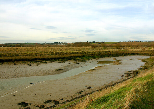
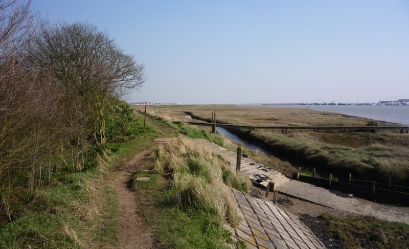
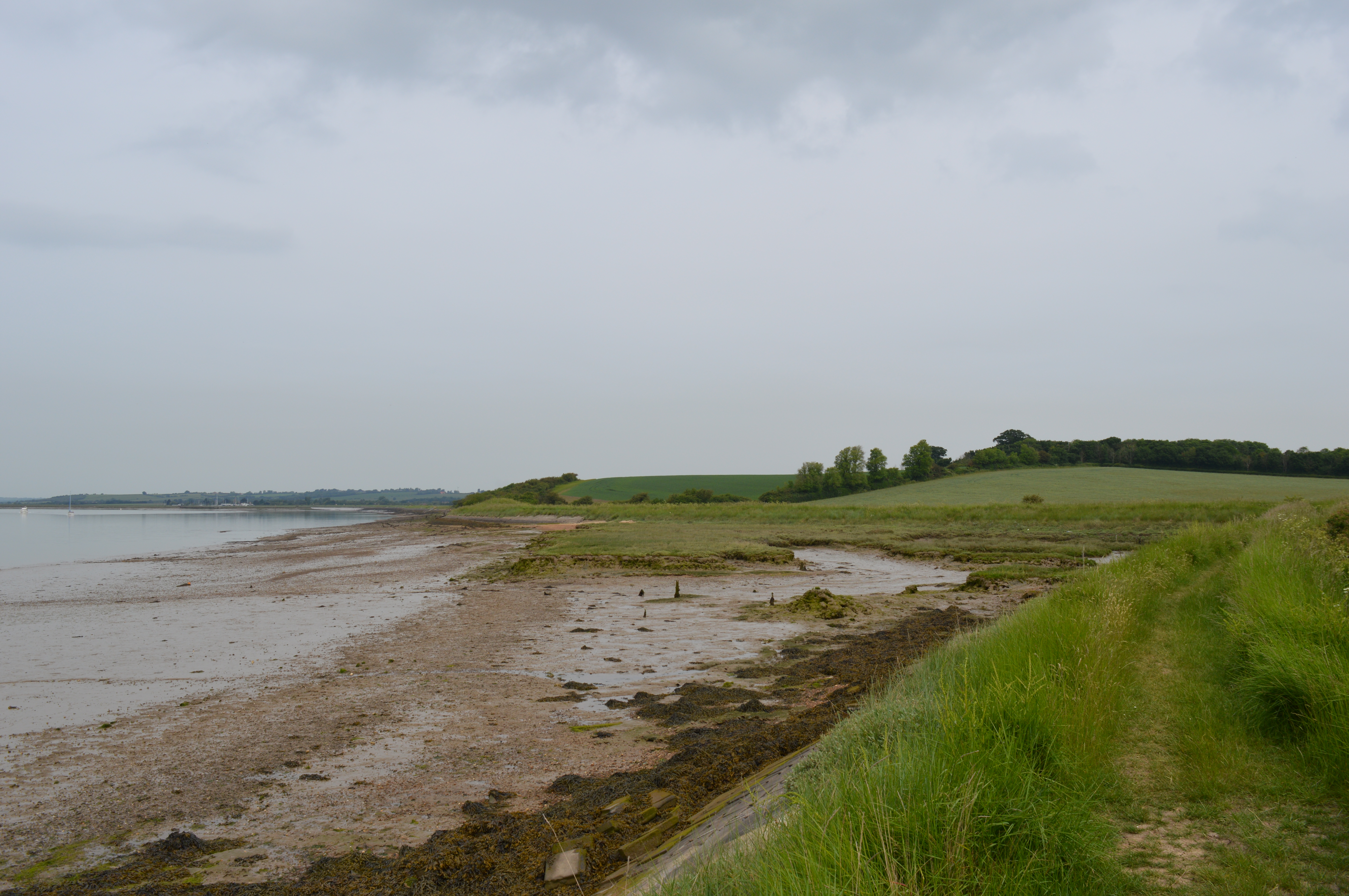
Cliff Reach is a picturesque location situated in Essex, England. It is renowned for its stunning views of the sea, estuary, and creek. This coastal area offers a unique blend of natural beauty and tranquility, making it a popular destination for nature lovers and outdoor enthusiasts.

The sea at Cliff Reach provides a breathtaking backdrop with its sparkling blue waters and crashing waves. Visitors can enjoy long walks along the sandy beaches, bask in the sun, or engage in various water activities such as swimming, surfing, and sailing. The clean and well-maintained beach makes it an ideal spot for families to relax and enjoy a day out.

The estuary, formed by the convergence of rivers and the sea, offers a diverse ecosystem and is a haven for birdwatchers. The area is home to a wide variety of bird species, including wading birds, waterfowl, and migratory birds. Bird enthusiasts can spend hours observing the unique behaviors and habitats of these feathered creatures.

Cliff Reach also boasts a beautiful creek, surrounded by lush greenery and marshes. This peaceful waterway is perfect for boating and kayaking, allowing visitors to explore the area's natural wonders at their own pace. The creek is teeming with marine life, and lucky visitors may even spot seals or dolphins swimming by.

Overall, Cliff Reach offers a serene and idyllic setting for those seeking a getaway from the hustle and bustle of city life. Its combination of sea, estuary, and creek makes it a haven for outdoor enthusiasts and nature lovers, providing a truly unforgettable experience.

If you have any feedback on the listing, please let us know in the comments section below.

Cliff Reach Images

Images are sourced within 2km of 51.632838/0.777789 or Grid Reference TQ9296. Thanks to Geograph Open Source API. All images are credited.

Burnham Yacht Harbour Marina
Near Raymonds Farm A view across farmland just north of Raymonds Farm. A section of farm track can be seen ahead.
Near Raymonds Farm
A view across farmland just north of Raymonds Farm. A section of farm track can be seen ahead.
Lagoon in Lion Creek Nature Reserve The reserve, which is also an SSI, is run by Essex Wildlife Trust. This is a view from their Garon Hide. See also a slightly different view (looking east) from the same hide 12 years ago from contributor Glyn Baker: <a href="https://www.geograph.org.uk/photo/1445511">TQ9295 : View From Garon Hide</a>
Lagoon in Lion Creek Nature Reserve
The reserve, which is also an SSI, is run by Essex Wildlife Trust. This is a view from their Garon Hide. See also a slightly different view (looking east) from the same hide 12 years ago from contributor Glyn Baker: TQ9295 : View From Garon Hide
Merit unloading at Baltic Wharf, Wallasea Island General Cargo ship Merit, in from Riga with a load of timber. View from near Burnham Marina
Merit unloading at Baltic Wharf, Wallasea Island
General Cargo ship Merit, in from Riga with a load of timber. View from near Burnham Marina
Creeksea Ferry Road The causeway onto Wallasea Island underwater near the top of a 5.4 metre spring tide. The large majority of tides do not get high enough to cover the road so this is quite a rare occurrence.
Creeksea Ferry Road
The causeway onto Wallasea Island underwater near the top of a 5.4 metre spring tide. The large majority of tides do not get high enough to cover the road so this is quite a rare occurrence.
Cliffords Farm Sluice & Bridgemarsh Island
Confluence of waterways near Bridgemarsh Marina Althorne Creek is in the foreground. Easter Reach can just be seen on the far side of the eastern tip of Bridgemarsh Island where the two waterways join to form Cliff Reach.
Confluence of waterways near Bridgemarsh Marina
Althorne Creek is in the foreground. Easter Reach can just be seen on the far side of the eastern tip of Bridgemarsh Island where the two waterways join to form Cliff Reach.
Drainage pond beside Althorne Creek
Inlet from Althorne Creek Taken looking north-west. The River View Park mobile homes site at Althorne can be seen on the horizon centre left.
Inlet from Althorne Creek
Taken looking north-west. The River View Park mobile homes site at Althorne can be seen on the horizon centre left.
Stokes Hall No. 3 drain, landward side
Stokes Hall No. 2 drain
Stokes Hall No. 1 sluice The Cliff, an exposure of London Clay once rich with fossils, can be seen ahead.
Stokes Hall No. 1 sluice
The Cliff, an exposure of London Clay once rich with fossils, can be seen ahead.
The Cliff This is an exposure of London Clay cut by a meander of the river Crouch upstream of Burnham and once rich in fossils.
The Cliff
This is an exposure of London Clay cut by a meander of the river Crouch upstream of Burnham and once rich in fossils.
Elm Farm Sluice
Elm Farm Sluice
All Saints, Creeksea - south elevation The church was virtually reconstructed from scratch in 1878-9 by Frederic Chancellor using much of the material from the previous, much older church. He also used a variety of 'exotic' (i.e. non-local) stones from a variety of locations. The architectural style of the new church has been described as “an ornate, almost fruity Perpendicular Gothic”.
All Saints, Creeksea - south elevation
The church was virtually reconstructed from scratch in 1878-9 by Frederic Chancellor using much of the material from the previous, much older church. He also used a variety of 'exotic' (i.e. non-local) stones from a variety of locations. The architectural style of the new church has been described as “an ornate, almost fruity Perpendicular Gothic”.
All Saints, Creeksea - north-east elevation The church was virtually reconstructed from scratch in 1878-9 by Frederic Chancellor using much of the material from the previous, much older church. He also used a variety of 'exotic' (i.e. non-local) stones from a variety of locations. The architectural style of the new church has been described as “an ornate, almost fruity Perpendicular Gothic”.
All Saints, Creeksea - north-east elevation
The church was virtually reconstructed from scratch in 1878-9 by Frederic Chancellor using much of the material from the previous, much older church. He also used a variety of 'exotic' (i.e. non-local) stones from a variety of locations. The architectural style of the new church has been described as “an ornate, almost fruity Perpendicular Gothic”.
All Saints, Creeksea - west elevation The church was virtually reconstructed from scratch in 1878-9 by Frederic Chancellor using much of the material from the previous, much older church. He also used a variety of 'exotic' (i.e. non-local) stones from a variety of locations. The architectural style of the new church has been described as “an ornate, almost fruity Perpendicular Gothic”.
All Saints, Creeksea - west elevation
The church was virtually reconstructed from scratch in 1878-9 by Frederic Chancellor using much of the material from the previous, much older church. He also used a variety of 'exotic' (i.e. non-local) stones from a variety of locations. The architectural style of the new church has been described as “an ornate, almost fruity Perpendicular Gothic”.
Creeksea Place - north frontage Creeksea Place dates from 1569 but has been extensively rebuilt and added to over the centuries. Today the main house and its ancillary buildings serve a variety of leisure and social purposes.
Creeksea Place - north frontage
Creeksea Place dates from 1569 but has been extensively rebuilt and added to over the centuries. Today the main house and its ancillary buildings serve a variety of leisure and social purposes.
Show me another place!

Cliff Reach is located at Grid Ref: TQ9296 (Lat: 51.632838, Lng: 0.777789)

Administrative County: Essex

District: Maldon

Police Authority: Essex

What 3 Words

///donation.binds.hairstyle. Near Burnham-on-Crouch, Essex

Nearby Locations

Cliff Reach The Cliff

Related Wikis

Creeksea

Creeksea is a village and former civil parish, now in the parish of Burnham-on-Crouch, in the Maldon district, in the county of Essex, England. It is on...

The Cliff, Burnham-on-Crouch

The Cliff, Burnham-on-Crouch is a 4 hectare geological Site of Special Scientific Interest (SSSI) on the bank of the River Crouch between Burnham-on-Crouch...

Creeksea Place

Creeksea Place is located near to the town of Burnham-on-Crouch in the Essex countryside of eastern England. Originally built in 1569, the estate retains...

Lion Creek and Lower Raypits

Lion Creek and Lower Raypits is a 65.2-hectare (161-acre) nature reserve east of Canewdon in Essex. It is part of the Crouch and Roach Estuaries Site of...

Ostend, Essex

Ostend is a hamlet in the English county of Essex. It is located about a mile north-west of the town of Burnham-on-Crouch where the population is included...

Burnham Ramblers F.C.

Burnham Ramblers Football Club is a football club based in Burnham-on-Crouch, Essex, England. They are currently members of the Eastern Counties League...

Burnham-on-Crouch railway station

Burnham-on-Crouch railway station is on the Crouch Valley Line in the East of England, serving the town of Burnham-on-Crouch, Essex. It is 43 miles 24...

Ormiston Rivers Academy

Ormiston Rivers Academy (formerly St Peter's High School) is a secondary school and sixth form with academy status located in Burnham-on-Crouch, Essex...

Nearby Amenities

Located within 500m of 51.632838,0.777789
Source: PGS
Lat/Long: 51.6361108/0.7762713
Source: PGS
Lat/Long: 51.6358577/0.7771082
Created By: dmgroom_coastlines
Source: PGS
Lat/Long: 51.6357767/0.7775738
Source: PGS
Lat/Long: 51.6354848/0.7775373
Created By: dmgroom_coastlines
Source: PGS
Lat/Long: 51.634802/0.779074
Created By: dmgroom_coastlines
Source: PGS
Lat/Long: 51.634306/0.779922
Source: PGS
Lat/Long: 51.63382/0.7805199
Created By: dmgroom_coastlines
Source: PGS
Lat/Long: 51.633305/0.781207
Created By: dmgroom_coastlines
Source: PGS
Lat/Long: 51.632801/0.781644
Created By: dmgroom_coastlines
Source: PGS
Lat/Long: 51.632296/0.78208
Created By: dmgroom_coastlines
Source: PGS
Lat/Long: 51.632048/0.782504
Source: PGS
Lat/Long: 51.6315825/0.7828374
Source: PGS
Lat/Long: 51.6308633/0.7834382
Source: PGS
Lat/Long: 51.6290247/0.7790671
Source: PGS
Lat/Long: 51.6294509/0.7786808
Source: PGS
Lat/Long: 51.630166/0.77786
Source: PGS
Lat/Long: 51.6311624/0.7764707
Source: PGS
Lat/Long: 51.6311624/0.7762883
Source: PGS
Lat/Long: 51.6312823/0.7763312
Source: PGS
Lat/Long: 51.6315953/0.7757519
Source: PGS
Lat/Long: 51.6323478/0.7751618
Source: PGS
Lat/Long: 51.6325942/0.7746897
Source: PGS
Lat/Long: 51.6330886/0.7730728
Source: PGS
Lat/Long: 51.6336493/0.7716519
Source: PGS
Lat/Long: 51.6337593/0.7714081
Seamark Buoy Special Purpose Category: yachting
Seamark Buoy Special Purpose Colour: yellow
Seamark Buoy Special Purpose Shape: spherical
Seamark Name: Cliff Reach
Seamark Topmark Colour: white
Seamark Topmark Shape: flag
Seamark Type: buoy_special_purpose
Lat/Long: 51.6334853/0.77855
Seamark Buoy Special Purpose Category: yachting
Seamark Buoy Special Purpose Colour: yellow
Seamark Buoy Special Purpose Shape: spherical
Seamark Name: Lands End
Seamark Topmark Colour: white
Seamark Topmark Shape: flag
Seamark Type: buoy_special_purpose
Lat/Long: 51.6346888/0.7713356
The data included in this document is from www.openstreetmap.org. The data is made available under ODbL.

Have you been to Cliff Reach?

Leave your review of Cliff Reach below (or comments, questions and feedback).