Mouth of the Kirn
Sea, Estuary, Creek in Shetland
Scotland
Mouth of the Kirn

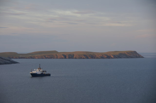
The Mouth of the Kirn is a prominent geographical feature located in the Shetland Islands, an archipelago in Scotland. Situated on the east coast of Mainland Shetland, the largest island in the group, it serves as an important entry point to the North Sea.
The Mouth of the Kirn can be described as an estuary, where the Kirn Water, a small river, meets the sea. The estuary is characterized by its wide, shallow channel and intricate network of tidal creeks and channels that stretch inland. These channels are influenced by the ebb and flow of the tides, creating an ever-changing landscape.
The area surrounding the Mouth of the Kirn is rich in biodiversity and provides a habitat for various species of birds, fish, and marine mammals. It is a popular spot for birdwatching, with a variety of seabirds, waders, and waterfowl being commonly observed.
The estuary also plays a crucial role in the local economy, supporting fishing and aquaculture industries. It provides a suitable environment for shellfish farming, particularly for mussels and scallops, contributing to the local seafood industry.
The Mouth of the Kirn is also significant historically and culturally. It has been used as a landing site for centuries, serving as a gateway for trade and transportation. The estuary is surrounded by picturesque landscapes, including rolling hills and cliffs, making it a popular destination for tourists and outdoor enthusiasts.
Overall, the Mouth of the Kirn is a dynamic and vital feature of the Shetland Islands, serving as a gateway to the North Sea, supporting diverse ecosystems, and contributing to the local economy and cultural heritage.
If you have any feedback on the listing, please let us know in the comments section below.
Mouth of the Kirn Images
Images are sourced within 2km of 59.982736/-1.2393715 or Grid Reference HU4222. Thanks to Geograph Open Source API. All images are credited.


Mouth of the Kirn is located at Grid Ref: HU4222 (Lat: 59.982736, Lng: -1.2393715)
Unitary Authority: Shetland Islands
Police Authority: Highlands and Islands
What 3 Words
///breaches.likewise.control. Near Sandwick, Shetland Islands
Nearby Locations
Related Wikis

Levenwick
Levenwick is a small village about 17 miles (27 km) south of Lerwick, on the east side of the South Mainland of Shetland, Scotland. It is part of the parish...

Sandwick, Dunrossness
see also Sandwick, Whalsay and Sandwick, OrkneySandwick (Old Norse: Sandvik "Sandy Bay") is a village and an ancient parish in the Shetland Islands, Scotland...

Hoswick
Hoswick is a settlement in Sandwick in the south mainland of Shetland, Scotland, on the eastern part of the Dunrossness civil parish. It is separated from...

Broch of Mousa
Broch of Mousa (or Mousa Broch) is a preserved Iron Age broch or round tower. It is on the island of Mousa in Shetland, Scotland. It is the tallest broch...

Mousa
Mousa (Old Norse: Mosey "moss island") is a small island in Shetland, Scotland, uninhabited since the nineteenth century. The island is known for the...

Clumlie Broch
Clumlie Broch is an Iron Age broch located on Mainland, Shetland, in Scotland (grid reference HU40451811). == Location == Clumlie Broch is located in Dunrossness...

Bigton
Bigton is a small settlement on South Mainland, Shetland, UK. Bigton is within the civil parish of Dunrossness.Bigton lies on the Atlantic coast of the...

Peerie Bard
Perie Bard is one of the Shetland Islands. It is a small islet off the east coast of the island of Mousa.Although named 'Perie Bard' on OS Maps, the name...
Have you been to Mouth of the Kirn?
Leave your review of Mouth of the Kirn below (or comments, questions and feedback).