Little Garron

Sea, Estuary, Creek in Aberdeenshire

Scotland

Little Garron

Trawlers in Peterhead's South Harbour Peterhead is the UK's premier white and pelagic fish port.
Trawlers in Peterhead's South Harbour Credit: Bob Jones

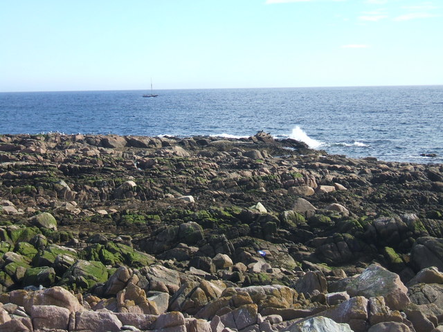
Little Garron is a small coastal settlement located in Aberdeenshire, Scotland. Situated alongside the North Sea, it boasts stunning views of the expansive ocean and the rugged coastline. The area is known for its picturesque estuary and creek, which add to the natural beauty of the surroundings.

The estuary of Little Garron is formed by the confluence of the Garron Burn and the North Sea. This estuarine environment is home to a diverse range of flora and fauna, making it a haven for nature lovers and birdwatchers. It provides an important habitat for various species of wading birds, including redshanks, oystercatchers, and curlews.

The creek of Little Garron, also known as Garron Burn, meanders through the settlement and adds to its charm. The creek provides a sheltered spot for small boats and a popular destination for recreational activities such as fishing and boating. The peaceful and serene ambiance of the creek offers a perfect escape from the hustle and bustle of city life.

Little Garron is not only famous for its natural attractions but also for its rich history. The area has archaeological remains dating back to the Bronze Age, including ancient burial mounds and standing stones. These historical sites add an air of mystery and intrigue to the area, attracting history enthusiasts and researchers.

In summary, Little Garron in Aberdeenshire is a delightful coastal settlement that offers breathtaking views of the North Sea, an estuary teeming with wildlife, and a tranquil creek for recreational activities. Its natural beauty and historical significance make it a popular destination for tourists and locals alike.

If you have any feedback on the listing, please let us know in the comments section below.

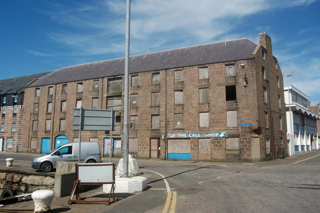
Little Garron Images

Images are sourced within 2km of 57.505382/-1.768224 or Grid Reference NK1346. Thanks to Geograph Open Source API. All images are credited.

Trawlers in Peterhead's South Harbour Peterhead is the UK's premier white and pelagic fish port.
Trawlers in Peterhead's South Harbour
Peterhead is the UK's premier white and pelagic fish port.
Buchanhaven Harbour In 1850 work started on a new pier, to replace an earlier small one to the west. This was to be the first stage in the building of a proper harbour basin for large herring boats. This plan was never completed. Buchanhaven Pier, as it stands today, did allow the fishermen to operate small-line boats. By the mid 1860s there were 27 boats working from the harbour.

The proximity of Peterhead and other larger fishing harbours eventually led to the demise of the harbour and nowadays only a few small boats use it.
Buchanhaven Harbour
In 1850 work started on a new pier, to replace an earlier small one to the west. This was to be the first stage in the building of a proper harbour basin for large herring boats. This plan was never completed. Buchanhaven Pier, as it stands today, did allow the fishermen to operate small-line boats. By the mid 1860s there were 27 boats working from the harbour. The proximity of Peterhead and other larger fishing harbours eventually led to the demise of the harbour and nowadays only a few small boats use it.
Peterhead marina
Peterhead marina
Peterhead Bay Sands and grass by the shore with an industrial offshore skyline due to oil rig work.
<span class="nowrap"><a title="http://en.wikipedia.org/wiki/Peterhead" rel="nofollow ugc noopener" href="http://en.wikipedia.org/wiki/Peterhead">Link</a><img style="margin-left:2px;" alt="External link" title="External link - shift click to open in new window" src="https://s1.geograph.org.uk/img/external.png" width="10" height="10"/></span>
Peterhead Bay
Sands and grass by the shore with an industrial offshore skyline due to oil rig work. LinkExternal link
Peterhead Bay East-facing bay at the Lido, south of the town centre.
Peterhead Bay
East-facing bay at the Lido, south of the town centre.
Caley Building, Peterhead The Caley building, at 26 Harbour Street, after undergoing renovations thanks to the CARS scheme.

The Peterhead CARS project (Conservation Area Regeneration Scheme) identified historical buildings at risk within the Peterhead Conservation Area, and grants were awarded to benefit various buildings such as the one in the photo.

More information can be found here... <span class="nowrap"><a title="http://www.aberdeenshire.gov.uk/built_heritage/PeterheadCARSsummaryatcompletion.pdf" rel="nofollow ugc noopener" href="http://www.aberdeenshire.gov.uk/built_heritage/PeterheadCARSsummaryatcompletion.pdf">Link</a><img style="margin-left:2px;" alt="External link" title="External link - shift click to open in new window" src="https://s1.geograph.org.uk/img/external.png" width="10" height="10"/></span>
Caley Building, Peterhead
The Caley building, at 26 Harbour Street, after undergoing renovations thanks to the CARS scheme. The Peterhead CARS project (Conservation Area Regeneration Scheme) identified historical buildings at risk within the Peterhead Conservation Area, and grants were awarded to benefit various buildings such as the one in the photo. More information can be found here... LinkExternal link
Peterhead harbour from the air Aerial photo taken from a plane flying between Aberdeen and Sumburgh.
Peterhead harbour from the air
Aerial photo taken from a plane flying between Aberdeen and Sumburgh.
At The Quayside A quiet Sunday morning in Peterhead.
At The Quayside
A quiet Sunday morning in Peterhead.
The Queenie Brig Replacing an 1850 swing bridge, this bascule bridge dates from 1954.
The Queenie Brig
Replacing an 1850 swing bridge, this bascule bridge dates from 1954.
Peterhead tolbooth
Peterhead tolbooth
Peterhead Lifeboat In dock at a quiet time ready to answer any call.
Peterhead Lifeboat
In dock at a quiet time ready to answer any call.
South Harbour, Peterhead
Ship repair yard, Scott's Pier, Peterhead
Peterhead lifeboat station
Icehouse, Peterhead South Harbour Peterhead is said to be Europe's most important white-fish port (see: <span class="nowrap"><a title="http://www.peterheadport.co.uk/fish_market.htm" rel="nofollow ugc noopener" href="http://www.peterheadport.co.uk/fish_market.htm">Link</a><img style="margin-left:2px;" alt="External link" title="External link - shift click to open in new window" src="https://s1.geograph.org.uk/img/external.png" width="10" height="10"/></span> ) and a ready supply of ice is vital...
Icehouse, Peterhead South Harbour
Peterhead is said to be Europe's most important white-fish port (see: LinkExternal link ) and a ready supply of ice is vital...
Harbour Street, Peterhead According to a plaque beside it, the cannon once protected the harbour from attacks by pirates...
Harbour Street, Peterhead
According to a plaque beside it, the cannon once protected the harbour from attacks by pirates...
Trawler, Peterhead South Harbour The Helenus (formerly the Heatherbelle V) registered to Fraserburgh as FR121.  She fairly bristles with radar and communication equipment.  She can be tracked here: <span class="nowrap"><a title="http://www.marinetraffic.com/ais/details/ships/shipid:185003/mmsi:233353000/imo:0/vessel:HELENUS_FR121" rel="nofollow ugc noopener" href="http://www.marinetraffic.com/ais/details/ships/shipid:185003/mmsi:233353000/imo:0/vessel:HELENUS_FR121">Link</a><img style="margin-left:2px;" alt="External link" title="External link - shift click to open in new window" src="https://s1.geograph.org.uk/img/external.png" width="10" height="10"/></span> .
Trawler, Peterhead South Harbour
The Helenus (formerly the Heatherbelle V) registered to Fraserburgh as FR121. She fairly bristles with radar and communication equipment. She can be tracked here: LinkExternal link .
Derelict warehouse, Harbour Street, Peterhead According to the new Pevsner guide to Aberdeenshire (North) and Moray, this building dates from about 1800 and is an "outstanding example" of the genre...
Derelict warehouse, Harbour Street, Peterhead
According to the new Pevsner guide to Aberdeenshire (North) and Moray, this building dates from about 1800 and is an "outstanding example" of the genre...
Show me another place!

Little Garron is located at Grid Ref: NK1346 (Lat: 57.505382, Lng: -1.768224)

Unitary Authority: Aberdeenshire

Police Authority: North East

What 3 Words

///tickets.starlight.savers. Near Peterhead, Aberdeenshire

Related Wikis

4 Union Street, Peterhead

4 Union Street is a Category C listed building in Peterhead, Aberdeenshire, Scotland. Dating to the late 18th century, the residential building stands...

Keith Inch

Keith Inch (originally Keith Insche, Keithinche or Caikinche) is the easternmost point of mainland Scotland, having formerly been an island. It is located...

75 Broad Street, Peterhead

75 Broad Street is a Category B listed building in Peterhead, Aberdeenshire, Scotland. It dates to 1835, and was originally a Clydesdale Bank. It is believed...

59 Broad Street, Peterhead

59 Broad Street is a Category B listed building in Peterhead, Aberdeenshire, Scotland. Dating to the mid 18th century, the residential building stands...

Nearby Amenities

Located within 500m of 57.505382,-1.768224
Source: OS7
Lat/Long: 57.508325/-1.772254
Source: OS7
Lat/Long: 57.5080009/-1.7715294
Source: OS7
Lat/Long: 57.5075833/-1.7704859
Source: OS7
Lat/Long: 57.5050026/-1.7690932
Source: OS7
Lat/Long: 57.5031824/-1.7670202
Source: OS7
Lat/Long: 57.5015119/-1.7686673
Source: OS7
Lat/Long: 57.5011162/-1.769113
Source: OS7
Lat/Long: 57.5020623/-1.7735957
Source: OS7
Lat/Long: 57.50242/-1.7727256
Source: OS7
Lat/Long: 57.5024018/-1.7724691
Source: OS7
Lat/Long: 57.5031417/-1.7722025
Source: OS7
Lat/Long: 57.503303/-1.7727335
Source: OS7
Lat/Long: 57.5041174/-1.7726177
Source: OS7
Lat/Long: 57.5043039/-1.773343
Source: OS7
Lat/Long: 57.5033834/-1.7738987
Source: OS7
Lat/Long: 57.5031088/-1.7740408
Source: OS7
Lat/Long: 57.5024974/-1.7734115
Source: OS7
Lat/Long: 57.5024133/-1.7734007
Source: OS7
Lat/Long: 57.501971/-1.7728733
Restaurant
Zara's
Addr City: Peterhead
Addr Housenumber: 11
Addr Postcode: AB42 1DB
Addr Street: Rose Street
Cuisine: indian
Email: info@zarasindiancuisine.com
Fhrs Authority: Aberdeenshire
Fhrs Id: 1273762
Fhrs Local Authority Id: 72048
Phone: +44 1779 475 599
Website: https://www.zarasindiancuisine.com
Lat/Long: 57.5044668/-1.7759558
Bank
Bank of Scotland
Addr Country: GB
Atm: yes
Brand: Bank of Scotland
Brand Wikidata: Q627381
Brand Wikipedia: en:Bank of Scotland
Contact Website: https://branches.bankofscotland.co.uk/peterhead/32-broad-street
Lat/Long: 57.5046968/-1.7763607
Noexit: yes
Lat/Long: 57.5042251/-1.7747194
Seamark Type: coastguard_station
Lat/Long: 57.502738/-1.7742249
Cafe
Dolphin Café
Lat/Long: 57.5028068/-1.7746276
Reform Monument
Historic: monument
Lat/Long: 57.5048621/-1.7760894
Source: OS7
Lat/Long: 57.5021399/-1.7680177
Source: OS7
Lat/Long: 57.5028293/-1.7662731
Source: OS7
Lat/Long: 57.5035866/-1.7680217
Source: OS7
Lat/Long: 57.5033932/-1.7684326
Source: OS7
Lat/Long: 57.5037875/-1.7688087
Source: OS7
Lat/Long: 57.5040508/-1.768842
Source: OS7
Lat/Long: 57.5044612/-1.7691255
Peterhead Fishery Office
Addr City: Peterhead
Addr Housename: Caley Buildings
Addr Housenumber: 28-32
Addr Postcode: AB42 1DJ
Addr Street: Harbour Street
Government: yes
Office: government
Lat/Long: 57.5043352/-1.7737014
Keith Inch
Place: suburb
Lat/Long: 57.5027807/-1.7700102
Roan Heads
Natural: rock
Lat/Long: 57.5092751/-1.7717526
Bank
Virgin Money
Addr City: Peterhead
Addr Housenumber: 43
Addr Postcode: AB42 1JB
Addr Street: Broad Street
Atm: yes
Brand: Virgin Money
Brand Wikidata: Q2527746
Brand Wikipedia: en:Clydesdale Bank
Source Addr Postcode: code-point_open
Website: http://www.cbonline.co.uk/
Lat/Long: 57.5050967/-1.7763745
North Harbour
Harbour: yes
Lat/Long: 57.5055934/-1.7715571
South Harbour
Harbour: yes
Lat/Long: 57.5033581/-1.7731311
Port Henry Basin
Harbour: yes
Lat/Long: 57.5066354/-1.7734406
The Misses Robertson of Kintail
Water Rescue
Emergency: water_rescue
Operator: Royal National Lifeboat Institution
Operator Short: RNLI
Operator Wikidata: Q2166873
Ref: 16-03
Seamark Name: The Misses Robertson of Kintail
Seamark Radio Station Category: ais
Seamark Radio Station Mmsi: 235030389
Seamark Rescue Station Category: lifeboat_on_mooring
Seamark Source: Bing;https://rnli.org/find-my-nearest/lifeboat-stations/peterhead-lifeboat-station/peterhead-lifeboat
Website: https://rnli.org/find-my-nearest/lifeboat-stations/peterhead-lifeboat-station/peterhead-lifeboat
Lat/Long: 57.5025129/-1.7736375
Post Box
Post Box Type: wall
Royal Cypher: GR
Royal Cypher Wikidata: Q33102273
Lat/Long: 57.5044269/-1.7736126
Traffic Calming: cushion
Lat/Long: 57.5057988/-1.7697191
Stop
Direction: backward
Lat/Long: 57.5047625/-1.7761073
Traffic Calming: cushion
Lat/Long: 57.5078547/-1.7718206
Traffic Calming: cushion
Lat/Long: 57.5064061/-1.7695346
Traffic Calming: cushion
Lat/Long: 57.5068857/-1.7696608
Traffic Calming: cushion
Lat/Long: 57.5075081/-1.7710633
Traffic Calming: cushion
Lat/Long: 57.5082447/-1.7726773
Traffic Calming: cushion
Lat/Long: 57.508737/-1.7737697
Alexandra Basin
Harbour: yes
Lat/Long: 57.5064901/-1.7707558
The data included in this document is from www.openstreetmap.org. The data is made available under ODbL.

Have you been to Little Garron?

Leave your review of Little Garron below (or comments, questions and feedback).