Radel Haven

Sea, Estuary, Creek in Aberdeenshire

Scotland

Radel Haven

Old Slains Castle
Old Slains Castle Credit: Alan Reid

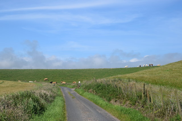
Radel Haven is a picturesque coastal location situated in Aberdeenshire, Scotland. Nestled between the North Sea and the River Dee, this charming haven is renowned for its stunning sea views, expansive estuary, and tranquil creek.

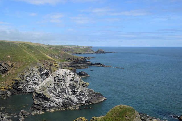
The sea surrounding Radel Haven offers breathtaking vistas, with its turquoise waters and rugged cliffs. The crashing waves provide a mesmerizing soundtrack, while the salty breeze invigorates visitors as they explore the area. The pristine sandy beaches are perfect for a leisurely stroll or a relaxing sunbathing session.

The estuary, formed by the River Dee, is a prominent feature of Radel Haven. This vast expanse of water is a haven for various species of birds and marine life. Birdwatchers flock to the area to catch a glimpse of the diverse avian population, including oystercatchers, herons, and terns. The estuary also serves as a popular spot for fishing, attracting both locals and tourists alike.

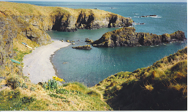
The creek at Radel Haven is a tranquil retreat offering a serene and idyllic atmosphere. Surrounded by verdant foliage, the creek provides a peaceful spot for picnics or simply enjoying the sounds of nature. Visitors often take advantage of the crystal-clear waters, engaging in activities such as kayaking or paddleboarding.

Overall, Radel Haven in Aberdeenshire is a breathtaking coastal location that offers a harmonious blend of sea, estuary, and creek. Its natural beauty and diverse wildlife make it a must-visit destination for nature enthusiasts and those seeking a peaceful getaway.

If you have any feedback on the listing, please let us know in the comments section below.

Radel Haven Images

Images are sourced within 2km of 57.366921/-1.9050392 or Grid Reference NK0530. Thanks to Geograph Open Source API. All images are credited.

Old Slains Castle
Old Slains Castle
Broad Haven Looking north-east up the coastline to Broad Haven.
Broad Haven
Looking north-east up the coastline to Broad Haven.
Mains of Slains Mains of Slains viewed from the road to the north.
Mains of Slains
Mains of Slains viewed from the road to the north.
Wetland near Blackhill Former loch adjacent to the A975 near Blackhill.
Wetland near Blackhill
Former loch adjacent to the A975 near Blackhill.
A species from the deep past The common horse-tail, Equisetum arvense, is an ancient species of plant whose ancestors were browsed by dinosaurs. Modern horsetails are only a few centimetres high but their ancestors included tree-like species up to 200 feet in height living in the Carboniferous forests. They all evolved long before the flowering plants came along and they produce spores rather than seeds. 

Horsetails grow in moist, rich soils in all parts of the world except Australasia. Some, including ours, produce two kinds of shoots. The first shoots to emerge in the spring are the reproductive squad and are topped with cone-like clusters of spore capsules. These are the ones in the photograph. In a couple of weeks time they will be replaced with green shoots whose role in life will be photosynthesis, growth and replenishing the energy stores.
A species from the deep past
The common horse-tail, Equisetum arvense, is an ancient species of plant whose ancestors were browsed by dinosaurs. Modern horsetails are only a few centimetres high but their ancestors included tree-like species up to 200 feet in height living in the Carboniferous forests. They all evolved long before the flowering plants came along and they produce spores rather than seeds. Horsetails grow in moist, rich soils in all parts of the world except Australasia. Some, including ours, produce two kinds of shoots. The first shoots to emerge in the spring are the reproductive squad and are topped with cone-like clusters of spore capsules. These are the ones in the photograph. In a couple of weeks time they will be replaced with green shoots whose role in life will be photosynthesis, growth and replenishing the energy stores.
Particoloured Tup This smart and rather unusual fellow was one of half a dozen tups roaming the cliffs. The others were mostly uniform in colour.
Particoloured Tup
This smart and rather unusual fellow was one of half a dozen tups roaming the cliffs. The others were mostly uniform in colour.
Fold Hinge Although it looks like a continuation, the section of the hinge in the black rocks is actually separated from the part on the left by a narrow sea inlet. This can be seen in <a href="https://www.geograph.org.uk/photo/1945678">NK0630 : Still More of the Recumbent Fold</a>.
Fold Hinge
Although it looks like a continuation, the section of the hinge in the black rocks is actually separated from the part on the left by a narrow sea inlet. This can be seen in NK0630 : Still More of the Recumbent Fold.
Folding the other way The most prominent hinges here close to the left, but this shows the other part of the structure, closing to the right, the whole forming an S-shaped fold.
Folding the other way
The most prominent hinges here close to the left, but this shows the other part of the structure, closing to the right, the whole forming an S-shaped fold.
Field Mushroom? I can't be certain what this is. There were several in the grass by the path. Any help with identification will be welcome.
Field Mushroom?
I can't be certain what this is. There were several in the grass by the path. Any help with identification will be welcome.
Mushrooms or Toadstools? Someone or something had uprooted the large fungus, so I moved it closer to the ones still in situ. I do not know what they are; I can only say that the large one did not smell at all appetising. Any help with identification welcome.
Mushrooms or Toadstools?
Someone or something had uprooted the large fungus, so I moved it closer to the ones still in situ. I do not know what they are; I can only say that the large one did not smell at all appetising. Any help with identification welcome.
South Newclochtow A clump of thistles clusters round the fence near South Newclochtow. There is barley on the field to the right, and grass with clover in the field on the left.
South Newclochtow
A clump of thistles clusters round the fence near South Newclochtow. There is barley on the field to the right, and grass with clover in the field on the left.
Hummel Craig Looking down on Hummel Craig from the clifftop path to the north.
Hummel Craig
Looking down on Hummel Craig from the clifftop path to the north.
Hummel Craig and un-named bay, Collieston
Looking towards Pottie Murlan from the coastal path For a close-up taken by Anne Burgess, see: <a title="https://www.geograph.org.uk/photo/6084" href="https://www.geograph.org.uk/photo/6084">Link</a> .
Looking towards Pottie Murlan from the coastal path
For a close-up taken by Anne Burgess, see: Link .
View of Hummel Craig from the coastal path... ...with the ruin of Old Slains Castle in the distance.   Craig is a Scottish word for 'crag' or a rock formation.
View of Hummel Craig from the coastal path...
...with the ruin of Old Slains Castle in the distance. Craig is a Scottish word for 'crag' or a rock formation.
View of Hummel Craig looking eastwards
View towards Old Slains Castle from the coastal path A couple of very isolated houses sit beside the ruin.
View towards Old Slains Castle from the coastal path
A couple of very isolated houses sit beside the ruin.
Cows in the countryside
Show me another place!

Radel Haven is located at Grid Ref: NK0530 (Lat: 57.366921, Lng: -1.9050392)

Unitary Authority: Aberdeenshire

Police Authority: North East

What 3 Words

///boost.corrupted.flap. Near Port Erroll, Aberdeenshire

Related Wikis

Old Slains Castle

Slains Castle (otherwise known as Old Slains Castle) is a ruined castle near Collieston in Aberdeenshire, Scotland. It is not to be confused with New Slains...

Collieston

Collieston is a small former fishing village on the North Sea coast in Aberdeenshire, Scotland. The village lies just north of the Sands of Forvie Special...

Meikle Loch

Meikle Loch is an inland loch some miles north of Collieston, Aberdeenshire, Scotland. It is designated as part of the Ythan Estuary complex, along with...

Whinnyfold

Whinnyfold or Whinneyfold is a small coastal village at the southern end of the Bay of Cruden in Aberdeenshire, Scotland. Whinnyfold (locally pronounced...

Nearby Amenities

Located within 500m of 57.366921,-1.9050392
Source: OS7
Lat/Long: 57.3698496/-1.898826
Source: OS7
Lat/Long: 57.368762/-1.9006563
Source: OS7
Lat/Long: 57.3675031/-1.9029952
Source: OS7
Lat/Long: 57.367241/-1.9034477
Source: Old Landsat image trace
Lat/Long: 57.367591/-1.9049918
Source: Old Landsat image trace
Lat/Long: 57.3665808/-1.9062686
Source: Old Landsat image trace
Lat/Long: 57.3658701/-1.9064239
Source: Old Landsat image trace
Lat/Long: 57.3651461/-1.9081029
Source: Old Landsat image trace
Lat/Long: 57.3656331/-1.9081257
Source: Old Landsat image trace
Lat/Long: 57.3656337/-1.9088349
Source: Old Landsat image trace
Lat/Long: 57.3659571/-1.9098627
Source: Old Landsat image trace
Lat/Long: 57.3651535/-1.9107811
Source: Old Landsat image trace
Lat/Long: 57.3642983/-1.9108434
The data included in this document is from www.openstreetmap.org. The data is made available under ODbL.

Have you been to Radel Haven?

Leave your review of Radel Haven below (or comments, questions and feedback).