Baunton

Settlement in Gloucestershire Cotswold

England

Baunton

Ermin Street, near Cirencester View south-east along Ermin Street, the former Roman road from Gloucester (Glevum) to Cirencester (Corinium) and beyond.
Ermin Street, near Cirencester Credit: Dave Bushell

Baunton is a small village located in the county of Gloucestershire, England. Situated approximately 2 miles southeast of the town of Cirencester, Baunton is nestled in the picturesque Cotswold countryside. With a population of around 300 residents, it exudes a quaint and peaceful ambiance.

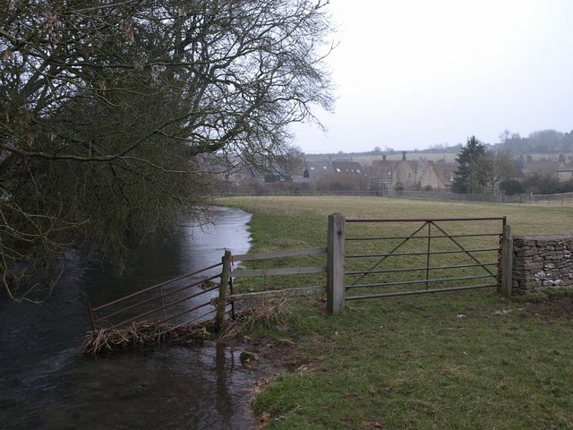
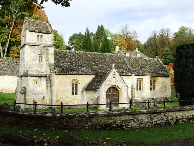
The village is known for its charming traditional Cotswold stone houses and buildings, which lend it a timeless and idyllic feel. Baunton is surrounded by rolling hills and expansive green fields, making it an ideal destination for nature lovers and outdoor enthusiasts. The nearby Baunton Downs offer scenic walking trails and panoramic views of the surrounding countryside.

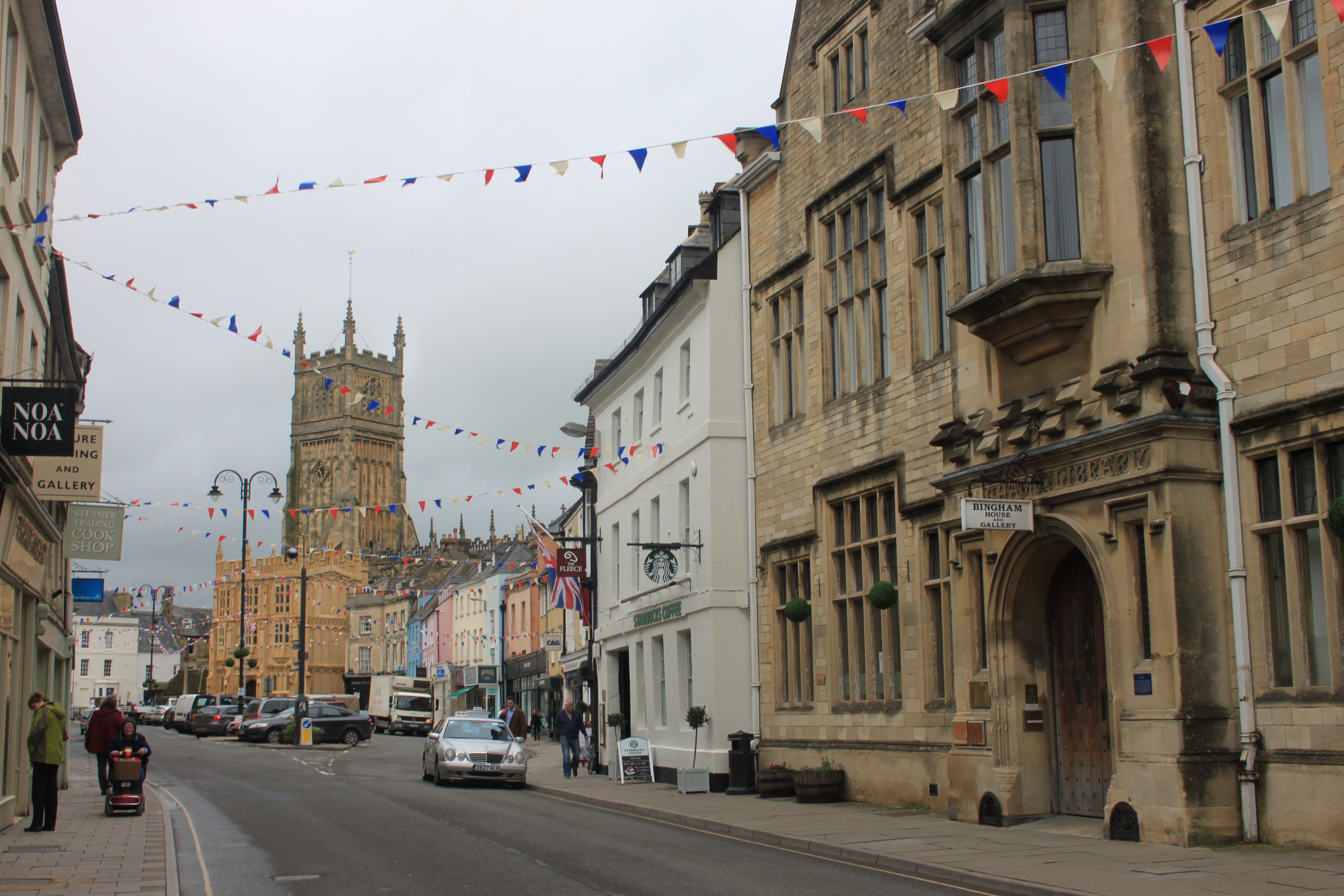
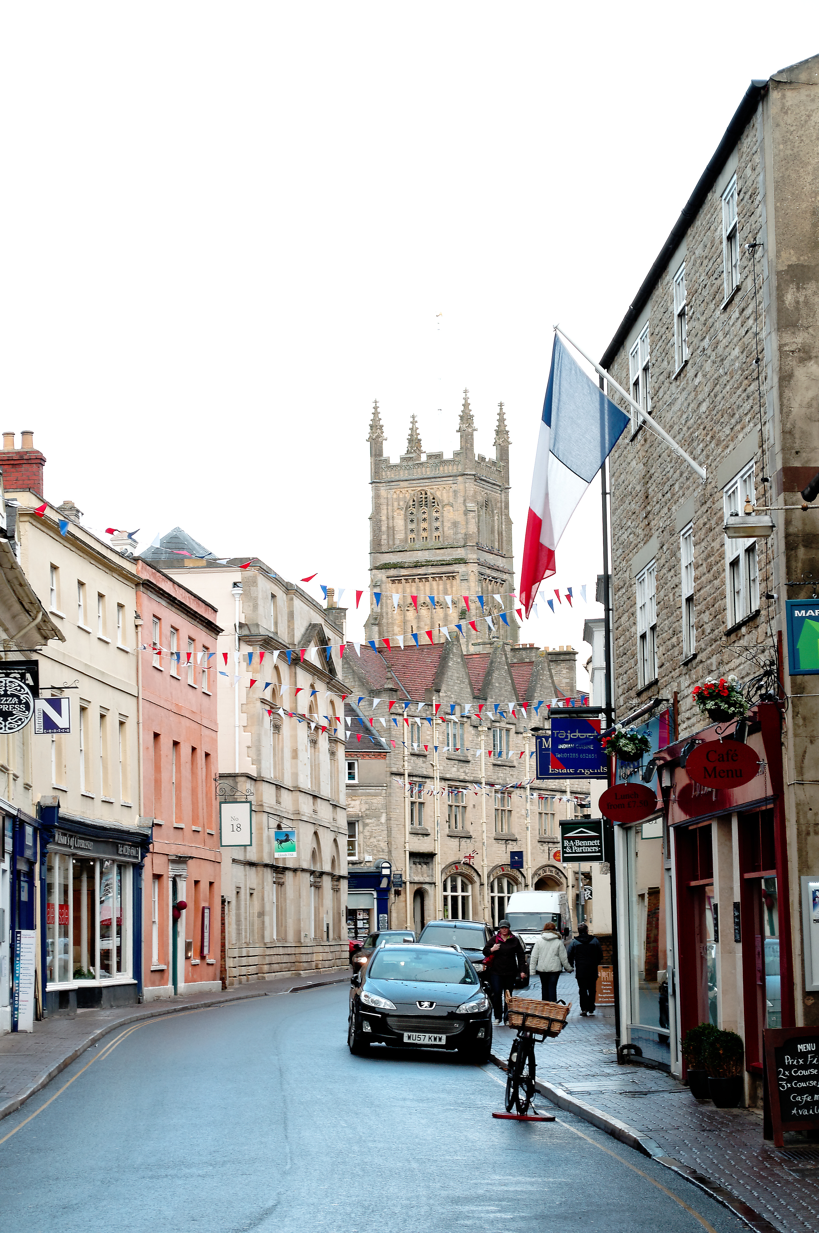
Although primarily a residential area, Baunton does not have its own shops or amenities. However, it benefits from its close proximity to Cirencester, where residents can find a wide range of shops, supermarkets, restaurants, and leisure facilities.

Baunton boasts a rich history, with evidence of settlement dating back to the Roman era. The nearby Cotswold Water Park, a popular recreational area, provides opportunities for boating, fishing, and birdwatching. Moreover, Baunton is well-connected to major transport routes, with easy access to the A417 and A419 roads, making it convenient for commuting or exploring the wider region.

Overall, Baunton offers a tranquil and picturesque setting, perfect for those seeking a quiet village lifestyle amidst the stunning natural beauty of the Cotswolds.

If you have any feedback on the listing, please let us know in the comments section below.

Baunton Images

Images are sourced within 2km of 51.739894/-1.968498 or Grid Reference SP0204. Thanks to Geograph Open Source API. All images are credited.

Ermin Street, near Cirencester View south-east along Ermin Street, the former Roman road from Gloucester (Glevum) to Cirencester (Corinium) and beyond.
Ermin Street, near Cirencester
View south-east along Ermin Street, the former Roman road from Gloucester (Glevum) to Cirencester (Corinium) and beyond.
Former Roman Road near Cirencester A view south-east along Ermin Street with Cirencester Parish Church in the distance. In Roman times, Cirencester was the second largest city in Britain and centre of a road network.
Former Roman Road near Cirencester
A view south-east along Ermin Street with Cirencester Parish Church in the distance. In Roman times, Cirencester was the second largest city in Britain and centre of a road network.
Ermin Street, Stratton Ermin Street running south-east through the village of Stratton, a community separated from Cirencester by former water meadows and mainly composed of a large housing estate
Ermin Street, Stratton
Ermin Street running south-east through the village of Stratton, a community separated from Cirencester by former water meadows and mainly composed of a large housing estate
Cirencester Golf Course Looking west from the Cheltenham Road across Cirencester Golf Course, designed in 1910
Cirencester Golf Course
Looking west from the Cheltenham Road across Cirencester Golf Course, designed in 1910
A417 near Cirencester Looking north-west from the White Way along the A417, Swindon to Gloucester road, near Baunton
A417 near Cirencester
Looking north-west from the White Way along the A417, Swindon to Gloucester road, near Baunton
Stratton Church Possibly on the line between squares! This is looking into the square. The church like many locally is some way from the modern suburb, separated by a main road, the old road to Gloucester.
Stratton Church
Possibly on the line between squares! This is looking into the square. The church like many locally is some way from the modern suburb, separated by a main road, the old road to Gloucester.
Baunton Church (winter!) View of the south side of the church
Baunton Church (winter!)
View of the south side of the church
Club house for Cirencester Golf Course.
The bridge of the A 417 over the A 435 near Cirencester.
Entrance to Perrot's Brook Farm.
Estate track into woodland known as The Sisters.
Gate into The Abbey Estate just off the A429 Beech leaves are on the ground in this late-November view.
Gate into The Abbey Estate just off the A429
Beech leaves are on the ground in this late-November view.
Part of Abbey Estate
The lane to Peewits Hill
Houses on the Whiteway Approaching Cirencester from the north
Houses on the Whiteway
Approaching Cirencester from the north
Powerlines near Baunton This is a view north-west as the powerlines change direction in this square. Farmland beneath.
Powerlines near Baunton
This is a view north-west as the powerlines change direction in this square. Farmland beneath.
Minor road near Baunton This is a view east from beneath the powerlines that cross this square. The road appears to be called Welsh Way. The road junction just visible in the distance is in this square.
Minor road near Baunton
This is a view east from beneath the powerlines that cross this square. The road appears to be called Welsh Way. The road junction just visible in the distance is in this square.
A417 Baunton The main connection between the M4 and M5 is shown here facing just north of west from the White Way.
A417 Baunton
The main connection between the M4 and M5 is shown here facing just north of west from the White Way.
Show me another place!

Baunton is located at Grid Ref: SP0204 (Lat: 51.739894, Lng: -1.968498)

Administrative County: Gloucestershire

District: Cotswold

Police Authority: Gloucestershire

What 3 Words

///hosts.packets.webcams. Near Stratton, Gloucestershire

Related Wikis

Baunton

Baunton is a village and civil parish in the Cotswold district of Gloucestershire, England, located about two miles north of Cirencester on the River...

Stratton, Gloucestershire

Stratton is a village, ward and former civil parish about 22 miles from Gloucester, now in the parish of Cirencester, in the Cotswold district, in the...

A417 road

The A417 is a main road in England running from Streatley, Berkshire to Hope under Dinmore, Herefordshire. It is best known for its section between Cirencester...

Bagendon

Bagendon is a village and civil parish in the Cotswold district of Gloucestershire, England, about four miles north of Cirencester. According to the 2001...

Cirencester Abbey

Cirencester Abbey or St Mary's Abbey, Cirencester in Gloucestershire was founded as an Augustinian monastery in 1117 on the site of an earlier church,...

Cotswold District

Cotswold is a local government district in Gloucestershire, England. It is named after the wider Cotswolds region and range of hills. The council is based...

Cirencester

Cirencester ( , occasionally ; see below for more variations) is a market town in Gloucestershire, England, 80 miles (130 km) west of London. Cirencester...

Battle of Cirencester

The Battle of Cirencester was fought in 628 at Cirencester in modern-day England. The conflict involved the armies of Mercia, under King Penda, and the...

Nearby Amenities

Located within 500m of 51.739894,-1.968498
Baunton
Is In: Gloucestershire, England, UK
Place: village
Lat/Long: 51.7392449/-1.9677653
Bus Stop
Cirencester Golf Club
Bus: yes
Naptan AtcoCode: 1600GLC179
Naptan Bearing: S
Naptan CommonName: Cirencester Golf Club
Naptan NaptanCode: glodwtjp
Naptan Street: Cheltenham Rd A435
Naptan Verified: no
Public Transport: platform
Source: naptan_import
Lat/Long: 51.7428072/-1.9737846
Bus Stop
Baunton Turn
Bus: yes
Naptan AtcoCode: 1600GLC181
Naptan Bearing: S
Naptan CommonName: Baunton Turn
Naptan NaptanCode: glogadjw
Naptan Street: Cheltenham Rd A435
Naptan Verified: no
Public Transport: platform
Source: naptan_import
Lat/Long: 51.7373304/-1.9695156
Bus Stop
Baunton Turn
Bus: yes
Naptan AtcoCode: 1600GLC182
Naptan Bearing: NW
Naptan CommonName: Baunton Turn
Naptan NaptanCode: glogadjp
Naptan Street: Cheltenham Rd A435
Naptan Verified: no
Public Transport: platform
Source: naptan_import
Lat/Long: 51.7385444/-1.9702244
Bus Stop
Cirencester Golf Club
Bus: yes
Naptan AtcoCode: 1600GLC180
Naptan Bearing: N
Naptan CommonName: Cirencester Golf Club
Naptan NaptanCode: glodwtjd
Naptan Street: Cheltenham Rd A435
Naptan Verified: no
Public Transport: platform
Source: naptan_import
Lat/Long: 51.7428881/-1.9738714
Telephone
Defibrillator
Booth: K6
Defibrillator Location: inside red phone box, Baunton
Emergency: defibrillator
Man Made: telephone_box
Ref GB Uprn: 10025225037
Lat/Long: 51.7395103/-1.9673732
Generator Source: solar
Power: generator
Lat/Long: 51.7394071/-1.9664951
Material: wood
Power: pole
Source: bing
Lat/Long: 51.7355187/-1.9670489
Material: wood
Power: pole
Source: bing
Lat/Long: 51.7388706/-1.9649059
Material: wood
Poles: bipole
Power: pole
Source: bing
Transformer: distribution
Lat/Long: 51.7393988/-1.9655134
Material: wood
Power: pole
Source: bing
Lat/Long: 51.7424266/-1.9625831
Material: wood
Power: pole
Source: bing
Transformer: distribution
Lat/Long: 51.7412756/-1.9639094
Material: wood
Power: pole
Source: bing
Lat/Long: 51.7404493/-1.9654101
Material: wood
Power: pole
Source: bing
Lat/Long: 51.7400557/-1.9664562
Material: wood
Power: pole
Source: bing
Lat/Long: 51.7376639/-1.9634199
Material: wood
Power: pole
Source: bing
Lat/Long: 51.7380866/-1.9647329
Material: wood
Power: pole
Source: bing
Lat/Long: 51.7372703/-1.964521
Material: wood
Power: pole
Source: bing
Lat/Long: 51.7366274/-1.9654329
Material: wood
Power: pole
Source: bing
Lat/Long: 51.736061/-1.9662617
Toilets
Unisex: yes
Lat/Long: 51.740713/-1.9700623
The Cotswold Curer
Addr City: Cirencester
Addr Postcode: GL7 7BG
Addr Street: Baunton Lane
Addr Village: Stratton
Fhrs Id: 809801
Shop: butcher
Website: https://www.thecotswoldcurer.com
Lat/Long: 51.7374274/-1.9728563
Barrier: stile
Lat/Long: 51.7369406/-1.9668235
Power: pole
Source: bing
Transformer: distribution
Lat/Long: 51.7373126/-1.9704486
Power: pole
Source: bing
Lat/Long: 51.7371772/-1.9711635
Power: pole
Source: bing
Transformer: distribution
Lat/Long: 51.7369389/-1.9724911
Power: pole
Source: bing
Lat/Long: 51.7418277/-1.9734275
Power: pole
Source: bing
Lat/Long: 51.7421729/-1.9730235
Power: pole
Source: bing
Lat/Long: 51.7426143/-1.9723545
Power: pole
Source: bing
Lat/Long: 51.7438525/-1.9704407
Power: pole
Source: bing
Lat/Long: 51.7434326/-1.971075
Power: pole
Source: bing
Lat/Long: 51.7430365/-1.9716965
Power: pole
Source: bing
Lat/Long: 51.7422894/-1.9696127
Power: pole
Source: bing
Lat/Long: 51.7412312/-1.9680992
Power: pole
Source: bing
Lat/Long: 51.741856/-1.9690095
The data included in this document is from www.openstreetmap.org. The data is made available under ODbL.

Have you been to Baunton?

Leave your review of Baunton below (or comments, questions and feedback).