Braddie's Cove

Sea, Estuary, Creek in Kincardineshire

Scotland

Braddie's Cove

Looking down into Trollochy Trollochy is a short, cliff girt inlet below Crawton.
Looking down into Trollochy Credit: Gordon Hatton

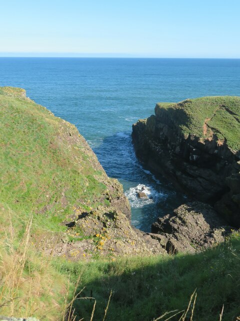
Braddie's Cove is a picturesque coastal area located in Kincardineshire, Scotland. Nestled between the North Sea and the estuary of the River Dee, it offers breathtaking views and a tranquil atmosphere. This idyllic cove is a hidden gem for nature enthusiasts and those seeking a peaceful retreat.

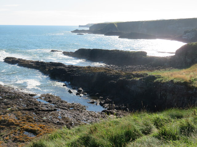
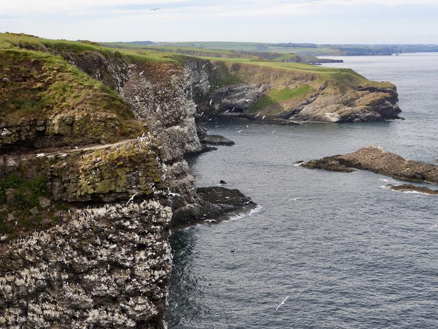
The cove is characterized by its pristine sandy beach that stretches for approximately half a mile along the coastline. The sand is soft and golden, perfect for leisurely walks or sunbathing on warm summer days. At low tide, the beach reveals numerous rock pools teeming with marine life, providing an exciting opportunity for exploration and discovery.

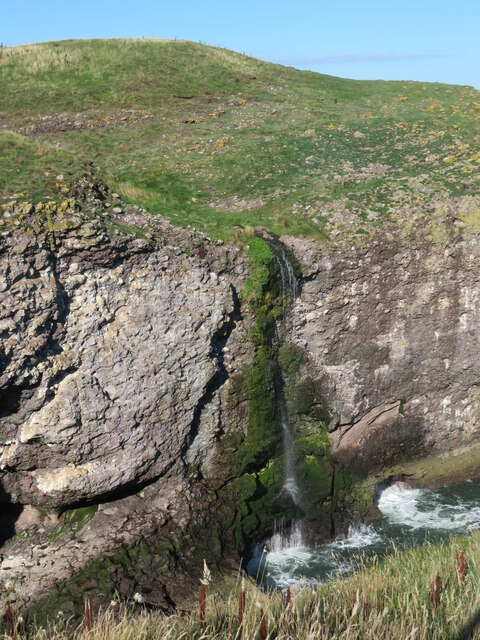
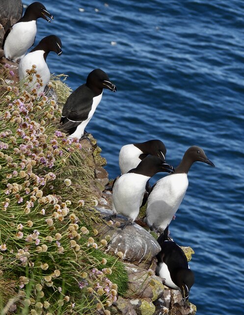
The estuary of the River Dee, which flows into the North Sea near Braddie's Cove, adds to the area's charm. The estuary serves as a habitat for a diverse range of bird species, making it a popular spot for birdwatching. Visitors may catch a glimpse of elegant herons, graceful swans, or even the occasional seal.

A small creek also meanders through Braddie's Cove, providing a serene and calming atmosphere. The creek is surrounded by lush greenery, including grassy dunes and coastal vegetation. It is an ideal spot for picnics or simply unwinding while enjoying the gentle sound of the water flowing.

Braddie's Cove offers a peaceful and unspoiled coastal experience, making it a favored destination for those seeking tranquility and natural beauty. Visitors can enjoy a serene beach, explore the rich marine life in the rock pools, marvel at the diverse bird species, or simply relish the calming ambiance of the creek.

If you have any feedback on the listing, please let us know in the comments section below.

Braddie's Cove Images

Images are sourced within 2km of 56.902626/-2.2049455 or Grid Reference NO8779. Thanks to Geograph Open Source API. All images are credited.

Looking down into Trollochy Trollochy is a short, cliff girt inlet below Crawton.
Looking down into Trollochy
Trollochy is a short, cliff girt inlet below Crawton.
Waterfall into the sea at Crawton A wee burn makes a dramatic plunge into the cliff bound inlet of Trollochy at Crawton.
Waterfall into the sea at Crawton
A wee burn makes a dramatic plunge into the cliff bound inlet of Trollochy at Crawton.
Rock ribs extending out into the sea at Crawton The view south from the small headland at Crawton where rocky reefs defy the waves. The view extends along Crawton Bay.
Rock ribs extending out into the sea at Crawton
The view south from the small headland at Crawton where rocky reefs defy the waves. The view extends along Crawton Bay.
Baler at work Tractor with baler working a harvested field near Cowieswells Farm.
Baler at work
Tractor with baler working a harvested field near Cowieswells Farm.
Razorbills and Guillemots Lives most of the year at sea, coming to land to breed. Both birds depends on the health of the marine environment. Fishing nets, pollution at sea and declining fish stocks all threaten these birds.
Razorbills and Guillemots
Lives most of the year at sea, coming to land to breed. Both birds depends on the health of the marine environment. Fishing nets, pollution at sea and declining fish stocks all threaten these birds.
Cliffs at Crawley Bird Sanctuary Not so many birds to be seen on the cliff face due to the devastation of Bird flu on the bird population.
Cliffs at Crawley Bird Sanctuary
Not so many birds to be seen on the cliff face due to the devastation of Bird flu on the bird population.
Daffodil Fields Rows of Daffodils growing by Braidon.
Daffodil Fields
Rows of Daffodils growing by Braidon.
Approaching the Barras turnoff from the A92 Photographer is above the paved roadway surface looking in the southbound direction along A92.
Approaching the Barras turnoff from the A92
Photographer is above the paved roadway surface looking in the southbound direction along A92.
Fields west of Catterline
Catterline Harbour The pier was built in the late 1830s. A few inshore fishing boats still use the harbour.
Catterline Harbour
The pier was built in the late 1830s. A few inshore fishing boats still use the harbour.
Catterline Bay Viewed from the road that leads down to the harbour.
Catterline Bay
Viewed from the road that leads down to the harbour.
Braidon Cottages A narrow road passes some rural dwellings lurking in the haar.
Braidon Cottages
A narrow road passes some rural dwellings lurking in the haar.
Catterline Burn
Catterline Burn
Caravan site, Cloak And cloaked in haar.
Caravan site, Cloak
And cloaked in haar.
A minor road near Catterline You can just see the foglights through the haar. There is a conifer shelter belt on the left, and the trees have thinned the fog enough to get a shot off.
A minor road near Catterline
You can just see the foglights through the haar. There is a conifer shelter belt on the left, and the trees have thinned the fog enough to get a shot off.
Farmland near Mill of Uras
Cotbank of Hilton
Cotbank of Hilton
New house, Cotbank of Hilton
Show me another place!

Braddie's Cove is located at Grid Ref: NO8779 (Lat: 56.902626, Lng: -2.2049455)

Unitary Authority: Aberdeenshire

Police Authority: North East

What 3 Words

///suits.expand.together. Near Stonehaven, Aberdeenshire

Related Wikis

Crawton

Crawton is a former fishing community on the southeast Aberdeenshire coast in Scotland, deserted since 1927. Approximately three miles south of Stonehaven...

Catterline

Catterline is a coastal village on the North Sea in Aberdeenshire, Scotland. It is situated about 5 miles (8.0 km) south of Stonehaven; nearby to the...

Fowlsheugh

Fowlsheugh is a coastal nature reserve in Kincardineshire, northeast Scotland, known for its 70-metre-high (230 ft) cliff formations and habitat supporting...

Craiglethy

Craiglethy (Scottish Gaelic: Creag Liathach - meaning grey rock) is a small island/skerry off Fowlsheugh on the east coast of Aberdeenshire, Scotland in...

Thornyhive Bay

Thornyhive Bay is an embayment along the North Sea coast in Aberdeenshire, Scotland. This bay is situated approximately 2.5 miles south of the town of...

Kinneff

Kinneff is a roadside hamlet in Aberdeenshire, Scotland, just north of Inverbervie. To the north lies another hamlet, Catterline. Kinneff also has a primary...

Dunnottar Castle

Dunnottar Castle (Scottish Gaelic: Dùn Fhoithear, "fort on the shelving slope") is a ruined medieval fortress located upon a rocky headland on the north...

Bowdun Head

Bowdun Head is a headland landform on the North Sea coast approximately one kilometre south of Stonehaven, Scotland.(Ordnance Survey, 2004) Slightly to...

Nearby Amenities

Located within 500m of 56.902626,-2.2049455
Source: PGS
Lat/Long: 56.8987614/-2.2071308
Source: PGS
Lat/Long: 56.8991208/-2.2070829
Source: PGS
Lat/Long: 56.8989593/-2.2076231
Source: PGS
Lat/Long: 56.8998781/-2.2080047
Created By: almien_coastlines
Source: PGS
Lat/Long: 56.900153/-2.207302
Created By: almien_coastlines
Source: PGS
Lat/Long: 56.900279/-2.207064
Source: PGS
Lat/Long: 56.9005252/-2.2062966
Source: PGS
Lat/Long: 56.9002191/-2.2061518
Source: PGS
Lat/Long: 56.9000829/-2.2059839
Source: PGS
Lat/Long: 56.8997313/-2.2055052
Source: PGS
Lat/Long: 56.9000658/-2.2049414
Source: PGS
Lat/Long: 56.9001789/-2.2032253
Source: PGS
Lat/Long: 56.902318/-2.2032457
Created By: almien_coastlines
Source: PGS
Lat/Long: 56.902444/-2.205147
Created By: almien_coastlines
Source: PGS
Lat/Long: 56.902698/-2.204908
Source: PGS
Lat/Long: 56.9032493/-2.2048722
Source: PGS
Lat/Long: 56.9037353/-2.2050983
Created By: almien_coastlines
Source: PGS
Lat/Long: 56.90398/-2.205114
Created By: almien_coastlines
Source: PGS
Lat/Long: 56.904748/-2.205098
Source: PGS
Lat/Long: 56.9048827/-2.2041622
Source: PGS
Lat/Long: 56.9047005/-2.2041324
Source: PGS
Lat/Long: 56.9045574/-2.2038049
Source: PGS
Lat/Long: 56.90421/-2.2035466
Source: PGS
Lat/Long: 56.9043106/-2.2026401
Source: PGS
Lat/Long: 56.9047088/-2.2027195
Source: PGS
Lat/Long: 56.9050074/-2.2035877
Created By: almien_coastlines
Source: PGS
Lat/Long: 56.905505/-2.203445
Created By: almien_coastlines
Source: PGS
Lat/Long: 56.906017/-2.203434
Created By: almien_coastlines
Source: PGS
Lat/Long: 56.906529/-2.203423
Created By: almien_coastlines
Source: PGS
Lat/Long: 56.906785/-2.203417
Trelong Bay
Natural: bay
Lat/Long: 56.8994185/-2.2062677
Turntrough Coves
Natural: bay
Lat/Long: 56.9039766/-2.2039288
Braddie's Cove
Natural: bay
Lat/Long: 56.9027346/-2.2043472
Power: pole
Lat/Long: 56.901564/-2.2124941
Power: pole
Lat/Long: 56.9015721/-2.2118221
The data included in this document is from www.openstreetmap.org. The data is made available under ODbL.

Have you been to Braddie's Cove?

Leave your review of Braddie's Cove below (or comments, questions and feedback).