Mol Mòr

Sea, Estuary, Creek in Sutherland

Scotland

Mol Mòr

On Island Roan The cliffs along the northern part are high.
On Island Roan Credit: David Bremner

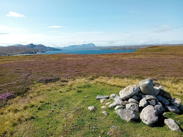
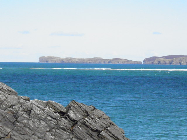
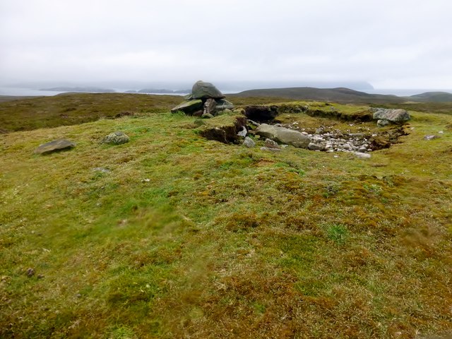
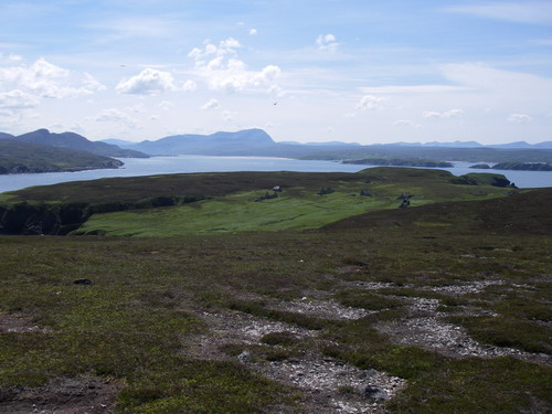
Mol Mòr, located in Sutherland, Scotland, is a picturesque coastal area that encompasses a sea, estuary, and creek. The name "Mol Mòr" translates to "big bay" in Gaelic, which aptly describes the expansive bay that stretches out into the North Atlantic Ocean.

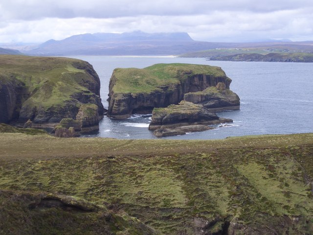
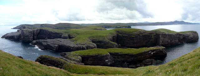
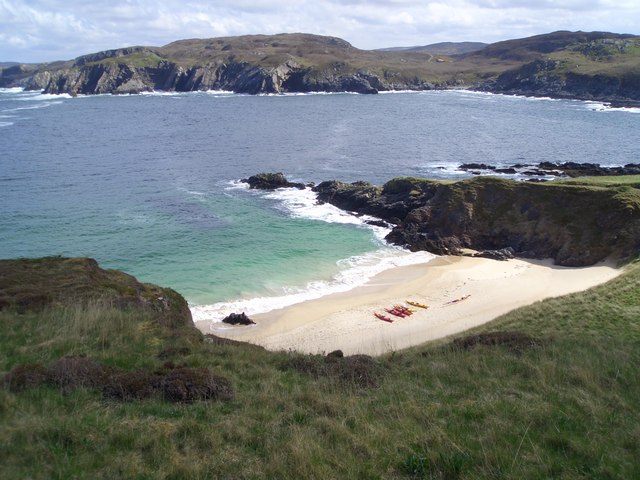
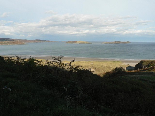
The sea at Mol Mòr is known for its stunning beauty and rugged coastline. It offers breathtaking views of waves crashing against towering cliffs, creating a dramatic and awe-inspiring sight. The crystal-clear waters are home to a diverse range of marine life, including seals, dolphins, and various species of fish.

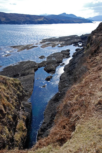
The estuary at Mol Mòr is formed where a river meets the sea, creating a unique blend of saltwater and freshwater environments. This convergence creates a rich and fertile habitat for numerous species of birds, including wading birds, ducks, and geese, making it a popular spot for birdwatching enthusiasts.

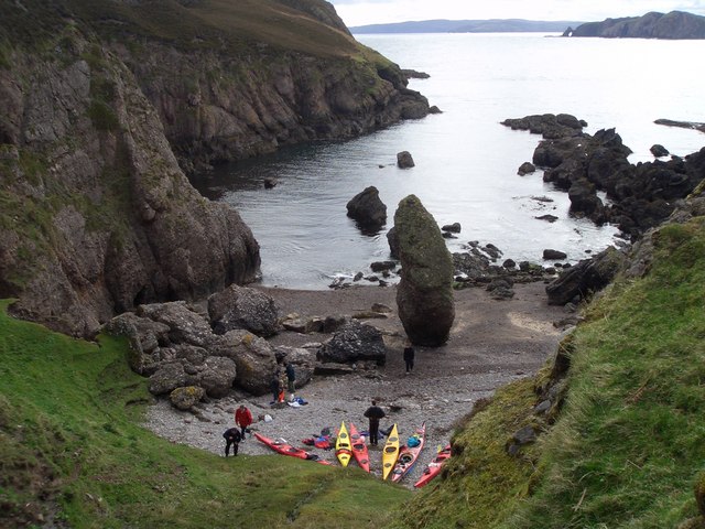
A creek also flows through Mol Mòr, meandering through the coastal landscape. The creek provides a tranquil and idyllic setting, with its calm waters reflecting the surrounding hills and vegetation. It is an ideal spot for kayaking, paddleboarding, or simply enjoying a peaceful stroll along its banks.

Overall, Mol Mòr offers a diverse and captivating coastal experience, with its sea, estuary, and creek providing a range of recreational activities and opportunities to appreciate the natural beauty of the Scottish coastline.

If you have any feedback on the listing, please let us know in the comments section below.

Mol Mòr Images

Images are sourced within 2km of 58.556026/-4.3469422 or Grid Reference NC6365. Thanks to Geograph Open Source API. All images are credited.

On Island Roan The cliffs along the northern part are high.
On Island Roan
The cliffs along the northern part are high.
Trig Point Trig point on Eilean nan Ron.
Trig Point
Trig point on Eilean nan Ron.
On Island Roan The Kyle of Tongue beyond.
On Island Roan
The Kyle of Tongue beyond.
Pool, Island Roan A wetter part of the island.
Pool, Island Roan
A wetter part of the island.
Eilean nan Ron from Bagh Challbacaidh (Coldbackie) The largest of the islands in Tongue Bay. The narrow channel between it and its smaller neighbour, Eilean Iosal, on the left is clearly seen.
Eilean nan Ron from Bagh Challbacaidh (Coldbackie)
The largest of the islands in Tongue Bay. The narrow channel between it and its smaller neighbour, Eilean Iosal, on the left is clearly seen.
Eilean nan Ron
Eilean nan Ron
Cnoc na Caillich Bagged on a boat trip with 8 other island TuMP baggers on a grey morning. We all bagged the trig first then celebrated Adrian's 2,000th TuMP here with malt and two cakes.
Name: Cnoc na Caillich
Hill number: 10033
Height: 76m / 249ft
Parent (Ma/M): none
Area: 16C: Tongue to Wick and Helmsdale
Class: 0
Grid ref: NC644655 (est)
Drop: 76m
Col: Sea
Cnoc na Caillich
Bagged on a boat trip with 8 other island TuMP baggers on a grey morning. We all bagged the trig first then celebrated Adrian's 2,000th TuMP here with malt and two cakes. Name: Cnoc na Caillich Hill number: 10033 Height: 76m / 249ft Parent (Ma/M): none Area: 16C: Tongue to Wick and Helmsdale Class: 0 Grid ref: NC644655 (est) Drop: 76m Col: Sea
Eilean Nan Ron Trig Point Bagged with 8 fellow island and TuMP baggers before celebrating Adrian Rayner's 2,000th TuMP on Cnoc Na Caillich.
Eilean Nan Ron Trig Point
Bagged with 8 fellow island and TuMP baggers before celebrating Adrian Rayner's 2,000th TuMP on Cnoc Na Caillich.
Geo south of Mol na Coinnle, Eilean nan Ron At low tide water is trapped in this geo making for an interesting snorkel or dive. In the summer months the temperature can rise well above the average sea temperature as the black rock absorbs the suns rays.
Geo south of Mol na Coinnle, Eilean nan Ron
At low tide water is trapped in this geo making for an interesting snorkel or dive. In the summer months the temperature can rise well above the average sea temperature as the black rock absorbs the suns rays.
Eilean Iosal Bagged on a boat trip with 8 other island TUMP baggers on a grey morning.
Name: Eilean Iosal
Hill number: 10096
Height: 49m / 161ft
Parent (Ma/M): none
Section: 16C: Tongue to Wick and Helmsdale
County/UA: Highland (UA)
Island: Eilean Iosal
Class: Tump (0-99m)
Grid ref: NC 63279 66158
Summit feature: no feature: ground by cliff edge
Drop: 49m
Col: Sea
Eilean Iosal
Bagged on a boat trip with 8 other island TUMP baggers on a grey morning. Name: Eilean Iosal Hill number: 10096 Height: 49m / 161ft Parent (Ma/M): none Section: 16C: Tongue to Wick and Helmsdale County/UA: Highland (UA) Island: Eilean Iosal Class: Tump (0-99m) Grid ref: NC 63279 66158 Summit feature: no feature: ground by cliff edge Drop: 49m Col: Sea
Meall Thailm Looked a difficult spot to land but a probable scrambling route over the two arches looked possible some day.
Name: Meall Thailm
Hill number: 10067
Height: 56m / 184ft
Parent (Ma/M): none
Section: 16C: Tongue to Wick and Helmsdale
County/UA: Highland (UA)
Island: Meall Thailm
Class: Tump (0-99m)
Grid ref: NC628662 (est)
Drop: 56m
Col: Sea
Meall Thailm
Looked a difficult spot to land but a probable scrambling route over the two arches looked possible some day. Name: Meall Thailm Hill number: 10067 Height: 56m / 184ft Parent (Ma/M): none Section: 16C: Tongue to Wick and Helmsdale County/UA: Highland (UA) Island: Meall Thailm Class: Tump (0-99m) Grid ref: NC628662 (est) Drop: 56m Col: Sea
Eilean Nan Ron This Photo was taken on an overnight camping trip to the Island of the seals. Taken May 2006
Eilean Nan Ron
This Photo was taken on an overnight camping trip to the Island of the seals. Taken May 2006
Eilean Nan Ron Taken on our wander round the island in the morning after our overnight camping trip.
Eilean Nan Ron
Taken on our wander round the island in the morning after our overnight camping trip.
Port na h-Uaille, Eilean nan Ron
Abandoned houses, Eilean nan Ron Ben Hope in background
Abandoned houses, Eilean nan Ron
Ben Hope in background
Natural Arch, Eilean nan Ron Neave Island in background
Natural Arch, Eilean nan Ron
Neave Island in background
Coast near Sletell
Coast near Sletell
Meall Thailm Meall Thailm with Eilean Iosal and Eilean nan Ron beyond.
Meall Thailm
Meall Thailm with Eilean Iosal and Eilean nan Ron beyond.
Show me another place!

Mol Mòr is located at Grid Ref: NC6365 (Lat: 58.556026, Lng: -4.3469422)

Unitary Authority: Highland

Police Authority: Highlands and Islands

What 3 Words

///permit.tunnel.harmlessly. Near Altnaharra, Highland

Related Wikis

Eilean nan Ròn

Eilean nan Ròn (Scottish Gaelic: island of the seals) is an island near Skerray, in the north of Sutherland, Scotland. An estimated 350 seal pups are born...

Skerray Bay

Skerray Bay is an arm of the Atlantic Ocean, located on the north coast of Sutherland, Highland, Scotland. Small and rocky, it is situated to the north...

Neave Island

Neave Island (Scottish Gaelic: Eilean na Naoimh, "Isle of the Saint") or Coomb(e) Island is an island on the north coast of the Scottish mainland. Neave...

Skerray

Skerray (Scottish Gaelic: Sgeirea) is a remote small crofting hamlet and fishing port on the north coast of Sutherland, Scotland. It is located 7+3⁄4 miles...

Achtoty

Achtoty (Scottish Gaelic: Achadh Toitidh) is a remote hamlet in the Scottish Highland Council area. Achtoty is about 26 miles (42 km) west of Thurso....

Skullomie

Scullomie is a small fishing and crofting township at the head of Tongue Bay in Sutherland in the Scottish Highlands. It is located around 3 miles (4...

Tongue Bay

Tongue Bay (Scottish Gaelic: Tunga from Old Norse: Tunga) is located in northwest Highland, Scotland, in the western part of the former county of Sutherland...

Melness

Melness (Gaelic: Taobh Mhealanais) is a locality, comprising a group of small remote crofting townships, lying to the west of Tongue Bay opposite Coldbackie...

Nearby Amenities

Located within 500m of 58.556026,-4.3469422
Source: PGS
Lat/Long: 58.5519713/-4.3495776
Source: PGS
Lat/Long: 58.5521501/-4.3494352
Source: PGS
Lat/Long: 58.5524878/-4.3489127
Source: PGS
Lat/Long: 58.5523865/-4.3486587
Source: PGS
Lat/Long: 58.5520892/-4.348791
Source: PGS
Lat/Long: 58.5519763/-4.3485466
Source: PGS
Lat/Long: 58.5521024/-4.3482262
Source: PGS
Lat/Long: 58.5522026/-4.3481019
Source: PGS
Lat/Long: 58.5524179/-4.3475094
Source: PGS
Lat/Long: 58.5523664/-4.3466055
Source: PGS
Lat/Long: 58.5528269/-4.346114
Source: PGS
Lat/Long: 58.5531032/-4.3450646
Source: PGS
Lat/Long: 58.5547599/-4.3460182
Source: PGS
Lat/Long: 58.5548859/-4.3462616
Source: PGS
Lat/Long: 58.5548255/-4.3467027
Created By: almien_coastlines
Source: PGS
Lat/Long: 58.554866/-4.347065
Source: PGS
Lat/Long: 58.5549617/-4.3473287
Source: PGS
Lat/Long: 58.5551381/-4.3472149
Source: PGS
Lat/Long: 58.5552157/-4.3469251
Source: PGS
Lat/Long: 58.5553399/-4.3469809
Source: PGS
Lat/Long: 58.5553876/-4.3465746
Source: PGS
Lat/Long: 58.5553042/-4.3461205
Source: PGS
Lat/Long: 58.5552871/-4.3456462
Source: PGS
Lat/Long: 58.5552379/-4.3451267
Source: PGS
Lat/Long: 58.5551587/-4.3447413
Source: PGS
Lat/Long: 58.555266/-4.344504
Source: PGS
Lat/Long: 58.5553653/-4.3438753
Source: PGS
Lat/Long: 58.5554643/-4.3431681
Source: PGS
Lat/Long: 58.5556831/-4.3437934
Created By: almien_coastlines
Source: PGS
Lat/Long: 58.55579/-4.344407
Created By: almien_coastlines
Source: PGS
Lat/Long: 58.556046/-4.344417
Source: PGS
Lat/Long: 58.5559695/-4.345063
Source: PGS
Lat/Long: 58.5560429/-4.3453374
Created By: almien_coastlines
Source: PGS
Lat/Long: 58.556161/-4.345645
Source: PGS
Lat/Long: 58.5561733/-4.3467435
Source: PGS
Lat/Long: 58.5565453/-4.346742
Source: PGS
Lat/Long: 58.5567867/-4.3482008
Source: PGS
Lat/Long: 58.5569462/-4.3481289
Source: PGS
Lat/Long: 58.5571565/-4.3482569
Created By: almien_coastlines
Source: PGS
Lat/Long: 58.557535/-4.348883
Source: PGS
Lat/Long: 58.5585003/-4.3494384
Source: PGS
Lat/Long: 58.5583817/-4.3494122
Created By: almien_coastlines
Source: PGS
Lat/Long: 58.558295/-4.349646
Source: PGS
Lat/Long: 58.5579183/-4.3500766
Source: PGS
Lat/Long: 58.5578409/-4.3507717
Source: PGS
Lat/Long: 58.5577165/-4.3511521
Source: PGS
Lat/Long: 58.5576023/-4.3513697
Source: PGS
Lat/Long: 58.5575538/-4.3520228
Source: PGS
Lat/Long: 58.5575991/-4.3525281
Source: PGS
Lat/Long: 58.5576816/-4.3530102
Source: PGS
Lat/Long: 58.5578738/-4.3532163
Source: PGS
Lat/Long: 58.5583275/-4.3530001
Source: PGS
Lat/Long: 58.5583415/-4.3536266
Source: PGS
Lat/Long: 58.558442/-4.3541052
Source: PGS
Lat/Long: 58.5600627/-4.349036
Created By: almien_coastlines
Source: PGS
Lat/Long: 58.560366/-4.347522
Source: PGS
Lat/Long: 58.560179/-4.3474606
Source: PGS
Lat/Long: 58.55987/-4.3475621
Source: PGS
Lat/Long: 58.5594217/-4.3482355
Source: PGS
Lat/Long: 58.5585926/-4.349156
Source: PGS
Lat/Long: 58.558274/-4.3481362
Source: PGS
Lat/Long: 58.559286/-4.347144
Source: PGS
Lat/Long: 58.5601206/-4.3466143
Source: PGS
Lat/Long: 58.5599239/-4.3449721
Source: PGS
Lat/Long: 58.5600303/-4.344799
Source: PGS
Lat/Long: 58.5598103/-4.3440917
Source: PGS
Lat/Long: 58.5592766/-4.3436761
Source: PGS
Lat/Long: 58.559734/-4.342888
Source: PGS
Lat/Long: 58.5594592/-4.3426948
Source: PGS
Lat/Long: 58.5587539/-4.3427482
Source: PGS
Lat/Long: 58.5588086/-4.3424348
Source: PGS
Lat/Long: 58.5595104/-4.3419899
Source: PGS
Lat/Long: 58.5591669/-4.3408194
Source: PGS
Lat/Long: 58.5581589/-4.3482368
Source: PGS
Lat/Long: 58.5585573/-4.3491957
The data included in this document is from www.openstreetmap.org. The data is made available under ODbL.

Have you been to Mol Mòr?

Leave your review of Mol Mòr below (or comments, questions and feedback).