Tamerton Lake

Sea, Estuary, Creek in Devon South Hams

England

Tamerton Lake

'Firestorm' off Skinham Point The yacht plods gently downstream along the River Tamar north of Saltash.
'Firestorm' off Skinham Point Credit: Stephen McKay

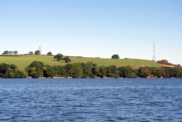
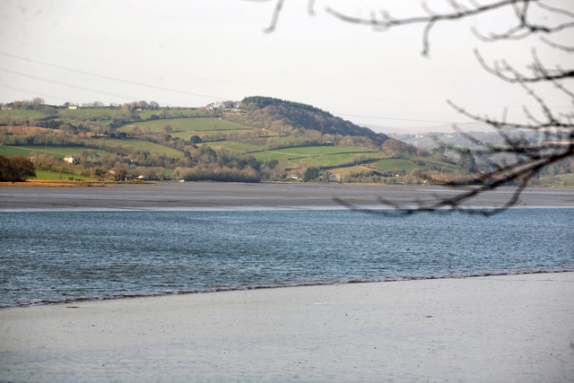
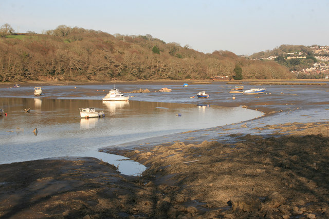
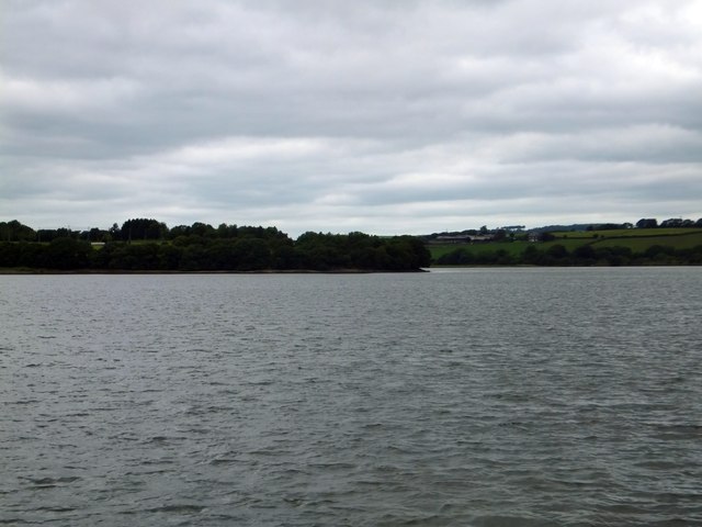
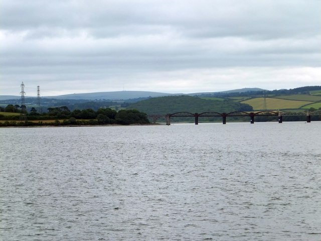
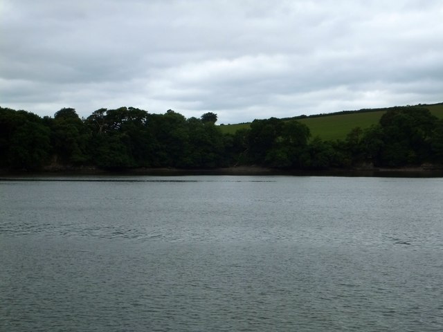
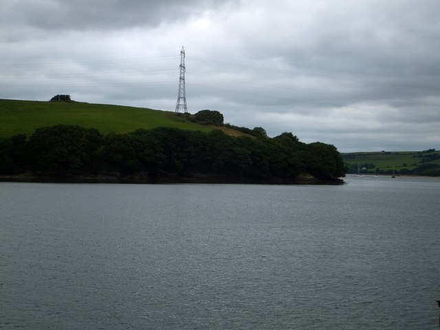
Tamerton Lake is a picturesque estuary located in Devon, England. It is situated near the village of Tamerton Foliot and is surrounded by lush greenery and rolling hills. The estuary is fed by the River Tamar and flows into the English Channel, providing a tranquil and scenic setting for visitors.

The water in Tamerton Lake is a mix of freshwater and saltwater, creating a unique ecosystem that supports a variety of plant and animal life. The estuary is home to a diverse range of bird species, including herons, swans, and ducks, making it a popular spot for birdwatching.

In addition to its natural beauty, Tamerton Lake also offers opportunities for outdoor activities such as fishing, boating, and kayaking. The calm waters and peaceful surroundings make it a perfect spot for a relaxing day out on the water.

Overall, Tamerton Lake is a hidden gem in Devon, offering visitors a chance to connect with nature and enjoy the serenity of the estuary. Whether you are looking to explore the wildlife, go fishing, or simply relax by the water, Tamerton Lake has something to offer for everyone.

If you have any feedback on the listing, please let us know in the comments section below.

Tamerton Lake Images

Images are sourced within 2km of 50.424452/-4.1839601 or Grid Reference SX4460. Thanks to Geograph Open Source API. All images are credited.

'Firestorm' off Skinham Point The yacht plods gently downstream along the River Tamar north of Saltash.
'Firestorm' off Skinham Point
The yacht plods gently downstream along the River Tamar north of Saltash.
River Tamar, near Landulph Looking from the water to the bank on the Cornish side between Neal Point and Weir Point.
River Tamar, near Landulph
Looking from the water to the bank on the Cornish side between Neal Point and Weir Point.
Moored yacht, River Tamar Between Thorn Point and Weir Point. The boat is pointing downstream as the tide comes in. On the east bank are fields near New Barn Farm.
Moored yacht, River Tamar
Between Thorn Point and Weir Point. The boat is pointing downstream as the tide comes in. On the east bank are fields near New Barn Farm.
Tamerton Foliot stream Station Road Tamerton Foliot stream as it flows towards Tamerton Creek.
Tamerton Foliot stream Station Road
Tamerton Foliot stream as it flows towards Tamerton Creek.
Crossing the Tavy Once the main LSWR railway line from Plymouth to Waterloo via Tavistock North and Crediton this is now the single line branch from Plymouth to Gunnislake. Crossing the river Tavy seen in the evening light at low tide.
Crossing the Tavy
Once the main LSWR railway line from Plymouth to Waterloo via Tavistock North and Crediton this is now the single line branch from Plymouth to Gunnislake. Crossing the river Tavy seen in the evening light at low tide.
Tavy viaduct An evening view of the river Tavy from Warleigh point . The 1729 Gunnislake to Plymouth train is on the viaduct.
Tavy viaduct
An evening view of the river Tavy from Warleigh point . The 1729 Gunnislake to Plymouth train is on the viaduct.
Warleigh Woods
Warleigh Woods
Looking up the River Tavy Taken from Warleigh woods by the Railway viaduct.
Looking up the River Tavy
Taken from Warleigh woods by the Railway viaduct.
Tamerton lake low tide
Winchester Gardens Council houses in Whitleigh.
Winchester Gardens
Council houses in Whitleigh.
Norwich Avenue Green space in Whitleigh.
Norwich Avenue
Green space in Whitleigh.
Winchester Gardens Council flats in Whitleigh.
Winchester Gardens
Council flats in Whitleigh.
Play area, Winchester Gardens
Tavy Bridge from Tamar Park Over two and half kilometres from the camera, across and up the Tamar estuary to the mouth of the Tavy.
Tavy Bridge from Tamar Park
Over two and half kilometres from the camera, across and up the Tamar estuary to the mouth of the Tavy.
Skinham Point seen from the Tamar The wooded point is the end of the Kingsmill Lake inlet.  The tide was high so the inlet was full of water
Skinham Point seen from the Tamar
The wooded point is the end of the Kingsmill Lake inlet. The tide was high so the inlet was full of water
Tavy Bridge carrying the Gunnislake to Plymouth railway line
The bay on the Tamar at Parsons Quay A wooded bay on the Cornish bank of the river, whose access is now a riverside footpath
The bay on the Tamar at Parsons Quay
A wooded bay on the Cornish bank of the river, whose access is now a riverside footpath
Weir Point and electricity pylon The pylon is higher than usual to allow the cables to cross the river.
Weir Point and electricity pylon
The pylon is higher than usual to allow the cables to cross the river.
Show me another place!

Tamerton Lake is located at Grid Ref: SX4460 (Lat: 50.424452, Lng: -4.1839601)

Administrative County: Devon

District: South Hams

Police Authority: Devon and Cornwall

What 3 Words

///vivid.pinch.mouse. Near Saltash, Cornwall

Nearby Locations

Warren Point Tamerton Lake

Related Wikis

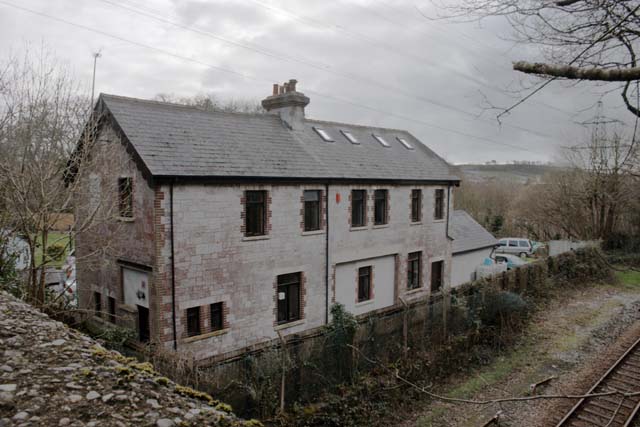
Tamerton Foliot railway station

Tamerton Foliot was a railway station, built by the Plymouth, Devonport and South Western Junction Railway (PDSWJR) on its line from Lydford to Devonport...

Warren Point County Wildlife Site

Warren Point County Wildlife Site is a wildlife park owned and managed by the city of Plymouth, Devon, England. Located in an industrial area, northwest...

Ernesettle

Ernesettle is mentioned in the Domesday Book, which documented land in England and Wales, and describes as an ‘old Saxon manor’ there. By the 15th century...
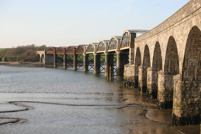
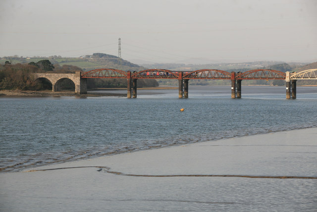
Tavy Bridge

Tavy Bridge is a railway bridge across the mouth of the River Tavy just east of its confluence with the River Tamar. It was built by the Plymouth, Devonport...

Nearby Amenities

Located within 500m of 50.424452,-4.1839601
Source: PGS
Lat/Long: 50.427132/-4.188627
Source: PGS
Lat/Long: 50.4270379/-4.188141
Source: PGS
Lat/Long: 50.4268635/-4.1877176
Source: PGS
Lat/Long: 50.4268056/-4.1874274
Source: PGS
Lat/Long: 50.4265205/-4.186508
Source: PGS
Lat/Long: 50.4266201/-4.1863923
Created By: almien_coastlines
Source: PGS
Lat/Long: 50.4246976/-4.1867591
Source: PGS
Lat/Long: 50.4245054/-4.1864804
Source: PGS
Lat/Long: 50.4247299/-4.1859957
Source: PGS
Lat/Long: 50.4246838/-4.1855457
Source: PGS
Lat/Long: 50.4251778/-4.1850476
Source: PGS
Lat/Long: 50.4258266/-4.1843762
Source: PGS
Lat/Long: 50.4255515/-4.1840452
Source: PGS
Lat/Long: 50.4254953/-4.1827398
Source: PGS
Lat/Long: 50.425593/-4.1820904
Source: PGS
Lat/Long: 50.4254538/-4.1812136
Source: PGS
Lat/Long: 50.4246352/-4.178371
Source: PGS
Lat/Long: 50.4241685/-4.1780483
Source: PGS
Lat/Long: 50.4240079/-4.1778284
Source: PGS
Lat/Long: 50.4239779/-4.1773971
Source: PGS
Lat/Long: 50.423704/-4.1864233
Source: PGS
Lat/Long: 50.4238421/-4.1871247
Source: PGS
Lat/Long: 50.4239438/-4.1879201
Source: PGS
Lat/Long: 50.4240272/-4.1888558
Source: PGS
Lat/Long: 50.424386/-4.189663
Source: PGS
Lat/Long: 50.4245916/-4.1900011
Source: PGS
Lat/Long: 50.4247709/-4.190821
Tamerton Foliot
Historic Railway: station
Railway: site
Source Name: NLS - OS 1:25k 1st Series
Wikidata: Q7681162
Lat/Long: 50.4265531/-4.1839435
Turning Circle
Source: Bing 2012
Lat/Long: 50.4219696/-4.1812709
Power: tower
Lat/Long: 50.4272123/-4.1826425
Power: tower
Lat/Long: 50.4265629/-4.1802212
Power: tower
Lat/Long: 50.4230124/-4.1878543
Power: tower
Lat/Long: 50.4236399/-4.1870592
Power: transformer
Voltage Primary: 132000
Voltage Secondary: medium
Lat/Long: 50.4229409/-4.1883551
Power: transformer
Voltage Primary: 132000
Voltage Secondary: medium
Lat/Long: 50.4226966/-4.1879716
Parking
Access: private
Fee: no
Park Ride: no
Parking: surface
Lat/Long: 50.4231591/-4.189375
Poles: bipole
Power: pole
Source: bing
Lat/Long: 50.427341/-4.1802683
Poles: bipole
Power: pole
Source: bing
Lat/Long: 50.4271908/-4.1811335
Generator Method: photovoltaic
Generator Output Electricity: yes
Generator Source: solar
Generator Type: solar_photovoltaic_panel
Location: roof
Power: generator
Lat/Long: 50.4214217/-4.1832885
Generator Method: photovoltaic
Generator Output Electricity: yes
Generator Source: solar
Generator Type: solar_photovoltaic_panel
Location: roof
Power: generator
Lat/Long: 50.4207108/-4.1833824
Generator Method: photovoltaic
Generator Output Electricity: yes
Generator Source: solar
Generator Type: solar_photovoltaic_panel
Location: roof
Power: generator
Lat/Long: 50.4207108/-4.1833341
Generator Method: photovoltaic
Generator Output Electricity: yes
Generator Source: solar
Generator Type: solar_photovoltaic_panel
Location: roof
Power: generator
Lat/Long: 50.4217293/-4.1827306
Generator Method: photovoltaic
Generator Output Electricity: yes
Generator Source: solar
Generator Type: solar_photovoltaic_panel
Location: roof
Power: generator
Lat/Long: 50.4223206/-4.1806841
Generator Method: photovoltaic
Generator Output Electricity: yes
Generator Source: solar
Generator Type: solar_photovoltaic_panel
Location: roof
Power: generator
Lat/Long: 50.4223343/-4.1807967
Generator Method: photovoltaic
Generator Output Electricity: yes
Generator Source: solar
Generator Type: solar_photovoltaic_panel
Location: roof
Power: generator
Lat/Long: 50.4224266/-4.181309
Generator Method: photovoltaic
Generator Output Electricity: yes
Generator Source: solar
Generator Type: solar_photovoltaic_panel
Location: roof
Power: generator
Lat/Long: 50.4224437/-4.1816551
Generator Method: photovoltaic
Generator Output Electricity: yes
Generator Source: solar
Generator Type: solar_photovoltaic_panel
Location: roof
Power: generator
Lat/Long: 50.4223719/-4.1821271
Generator Method: photovoltaic
Generator Output Electricity: yes
Generator Source: solar
Generator Type: solar_photovoltaic_panel
Location: roof
Power: generator
Lat/Long: 50.4218165/-4.1821191
Generator Method: photovoltaic
Generator Output Electricity: yes
Generator Source: solar
Generator Type: solar_photovoltaic_panel
Location: roof
Power: generator
Lat/Long: 50.4216456/-4.181706
Generator Method: photovoltaic
Generator Output Electricity: yes
Generator Source: solar
Generator Type: solar_photovoltaic_panel
Location: roof
Power: generator
Lat/Long: 50.4215943/-4.1814834
Generator Method: photovoltaic
Generator Output Electricity: yes
Generator Source: solar
Generator Type: solar_photovoltaic_panel
Location: roof
Power: generator
Lat/Long: 50.4215619/-4.181309
Generator Method: photovoltaic
Generator Output Electricity: yes
Generator Source: solar
Generator Type: solar_photovoltaic_panel
Location: roof
Power: generator
Lat/Long: 50.4211039/-4.1810221
Generator Method: photovoltaic
Generator Output Electricity: yes
Generator Source: solar
Generator Type: solar_photovoltaic_panel
Location: roof
Power: generator
Lat/Long: 50.4210919/-4.1809389
Generator Method: photovoltaic
Generator Output Electricity: yes
Generator Source: solar
Generator Type: solar_photovoltaic_panel
Location: roof
Power: generator
Lat/Long: 50.4210885/-4.1808665
Generator Method: photovoltaic
Generator Output Electricity: yes
Generator Source: solar
Generator Type: solar_photovoltaic_panel
Location: roof
Power: generator
Lat/Long: 50.4210252/-4.1807565
Generator Method: photovoltaic
Generator Output Electricity: yes
Generator Source: solar
Generator Type: solar_photovoltaic_panel
Location: roof
Power: generator
Lat/Long: 50.4205707/-4.1807538
Generator Method: photovoltaic
Generator Output Electricity: yes
Generator Source: solar
Generator Type: solar_photovoltaic_panel
Location: roof
Power: generator
Lat/Long: 50.4205655/-4.180676
Generator Method: photovoltaic
Generator Output Electricity: yes
Generator Source: solar
Generator Type: solar_photovoltaic_panel
Location: roof
Power: generator
Lat/Long: 50.4207518/-4.1804105
Generator Method: photovoltaic
Generator Output Electricity: yes
Generator Source: solar
Generator Type: solar_photovoltaic_panel
Location: roof
Power: generator
Lat/Long: 50.4206903/-4.1802147
Generator Method: photovoltaic
Generator Output Electricity: yes
Generator Source: solar
Generator Type: solar_photovoltaic_panel
Location: roof
Power: generator
Lat/Long: 50.4206749/-4.180153
Generator Method: photovoltaic
Generator Output Electricity: yes
Generator Source: solar
Generator Type: solar_photovoltaic_panel
Location: roof
Power: generator
Lat/Long: 50.4210013/-4.1804722
Generator Method: photovoltaic
Generator Output Electricity: yes
Generator Source: solar
Generator Type: solar_photovoltaic_panel
Location: roof
Power: generator
Lat/Long: 50.420933/-4.1803086
Generator Method: photovoltaic
Generator Output Electricity: yes
Generator Source: solar
Generator Type: solar_photovoltaic_panel
Location: roof
Power: generator
Lat/Long: 50.420921/-4.1802093
Generator Method: photovoltaic
Generator Output Electricity: yes
Generator Source: solar
Generator Type: solar_photovoltaic_panel
Location: roof
Power: generator
Lat/Long: 50.4209005/-4.1800913
Generator Method: photovoltaic
Generator Output Electricity: yes
Generator Source: solar
Generator Type: solar_photovoltaic_panel
Location: roof
Power: generator
Lat/Long: 50.420827/-4.1799411
Generator Method: photovoltaic
Generator Output Electricity: yes
Generator Source: solar
Generator Type: solar_photovoltaic_panel
Location: roof
Power: generator
Lat/Long: 50.4210987/-4.1796139
Generator Method: photovoltaic
Generator Output Electricity: yes
Generator Source: solar
Generator Type: solar_photovoltaic_panel
Location: roof
Power: generator
Lat/Long: 50.4210594/-4.1794583
Generator Method: photovoltaic
Generator Output Electricity: yes
Generator Source: solar
Generator Type: solar_photovoltaic_panel
Location: roof
Power: generator
Lat/Long: 50.4210389/-4.1793591
Location Transition: yes
Power: pole
Source: bing
Lat/Long: 50.4271634/-4.1802295
Poles: bipole
Power: pole
Source: bing
Lat/Long: 50.4272617/-4.180267
Poles: bipole
Power: pole
Source: bing
Lat/Long: 50.4273052/-4.1811723
Tourism: viewpoint
Lat/Long: 50.4260585/-4.1851709
Bench
Backrest: no
Lat/Long: 50.422787/-4.1869862
Bench
Backrest: no
Material: metal
Survey Date: 2023-05-27
Lat/Long: 50.4231877/-4.1835364
Bus Stop
Tangmere Avenue
Bench: yes
Bin: no
Bus: yes
Departures Board: timetable
Lit: yes
Naptan AtcoCode: 1180PLA10133
Naptan Bearing: SW
Naptan CommonName: Tangmere Avenue
Naptan Indicator: SW-bound
Naptan NaptanCode: plyagmd
Naptan PlusbusZoneRef: PLYMTH
Naptan Street: Lakeside Drive
Naptan Verified: no
Public Transport: platform
Shelter: yes
Tactile Paving: yes
Lat/Long: 50.4219495/-4.1832643
Source: PGS
Lat/Long: 50.4266257/-4.1868785
Waste Basket
Survey Date: 2022-01-15
Lat/Long: 50.4231285/-4.1826235
Life Ring
Emergency: life_ring
Survey Date: 2022-01-15
Lat/Long: 50.4231861/-4.1841985
Bench
Backrest: yes
Survey Date: 2022-01-15
Lat/Long: 50.4231496/-4.1842542
Bus Stop
Lakeside Drive
Bench: yes
Bus: yes
Naptan AtcoCode: 1180PLA10134
Naptan Bearing: W
Naptan CommonName: Lakeside Drive
Naptan Indicator: W-bound
Naptan NaptanCode: plyajmd
Naptan PlusbusZoneRef: PLYMTH
Naptan Street: Lakeside Drive
Public Transport: platform
Shelter: yes
Survey Date: 2022-01-15
Lat/Long: 50.4222145/-4.1798098
Fire Hydrant
Emergency: fire_hydrant
Fire Hydrant Type: underground
Survey Date: 2022-01-15
Lat/Long: 50.4220387/-4.179295
Bench
Backrest: yes
Survey Date: 2022-01-15
Lat/Long: 50.4222128/-4.1799189
Street Lamp
Ref: 10
Survey Date: 2022-04-07
Lat/Long: 50.4220509/-4.1829067
Street Lamp
Ref: 9
Survey Date: 2022-03-24
Lat/Long: 50.4215263/-4.1802478
Man Made: street_cabinet
Survey Date: 2022-03-24
Lat/Long: 50.4211317/-4.180497
Fire Hydrant
Emergency: fire_hydrant
Fire Hydrant Type: underground
Survey Date: 2022-03-24
Lat/Long: 50.4210825/-4.1805199
Street Lamp
Ref: 3
Survey Date: 2022-03-24
Lat/Long: 50.4202468/-4.1817337
Street Lamp
Ref: 2
Survey Date: 2022-03-24
Lat/Long: 50.4205495/-4.1817309
Street Lamp
Survey Date: 2022-03-24
Lat/Long: 50.4218576/-4.1834572
Man Made: utility_pole
Material: wood
Survey Date: 2022-03-24
Lat/Long: 50.4218323/-4.1833524
Street Lamp
Ref: 26
Survey Date: 2022-04-07
Lat/Long: 50.4219774/-4.1832484
Street Lamp
Ref: 9
Survey Date: 2022-04-07
Lat/Long: 50.4218305/-4.1826695
Street Lamp
Ref: 6
Survey Date: 2022-04-07
Lat/Long: 50.4213791/-4.1814642
Telephone
Booth: KX100
Covered: booth
Survey Date: 2022-03-24
Lat/Long: 50.4212798/-4.1810937
Street Lamp
Ref: 5
Survey Date: 2022-03-24
Lat/Long: 50.4213284/-4.1809835
Street Lamp
Survey Date: 2022-03-24
Lat/Long: 50.4217589/-4.1805681
Street Lamp
Survey Date: 2022-03-24
Lat/Long: 50.4217461/-4.1801856
Street Lamp
Survey Date: 2022-03-24
Lat/Long: 50.4215342/-4.1794181
Street Lamp
Ref: 7
Survey Date: 2022-03-24
Lat/Long: 50.4213738/-4.1790559
Street Lamp
Survey Date: 2022-03-24
Lat/Long: 50.4215839/-4.1798094
Man Made: street_cabinet
Survey Date: 2022-03-24
Lat/Long: 50.4212064/-4.1804692
Street Lamp
Ref: 2
Survey Date: 2022-03-24
Lat/Long: 50.4207677/-4.180612
Man Made: street_cabinet
Survey Date: 2022-03-24
Lat/Long: 50.4206408/-4.180573
Street Lamp
Survey Date: 2022-03-24
Lat/Long: 50.4202227/-4.1825392
Fire Hydrant
Emergency: fire_hydrant
Fire Hydrant Diameter: 100
Fire Hydrant Position: sidewalk
Fire Hydrant Type: underground
Survey Date: 2022-03-24
Lat/Long: 50.4202648/-4.1825372
Street Lamp
Ref: 6
Survey Date: 2022-03-24
Lat/Long: 50.4204907/-4.1823753
Street Lamp
Ref: 7
Survey Date: 2022-04-07
Lat/Long: 50.4215122/-4.1819354
Fire Hydrant
Emergency: fire_hydrant
Fire Hydrant Diameter Signed: no
Fire Hydrant Position: sidewalk
Fire Hydrant Type: underground
Survey Date: 2022-03-24
Lat/Long: 50.4212549/-4.1807355
Street Lamp
Survey Date: 2022-03-24
Lat/Long: 50.4219364/-4.1808553
Street Lamp
Ref: 1
Survey Date: 2022-03-24
Lat/Long: 50.4210402/-4.1805489
Man Made: street_cabinet
Survey Date: 2022-03-24
Lat/Long: 50.420499/-4.1825001
Man Made: utility_pole
Material: wood
Survey Date: 2022-03-24
Lat/Long: 50.4203866/-4.1821419
Street Lamp
Ref: 5
Survey Date: 2022-03-24
Lat/Long: 50.4204113/-4.1819232
Man Made: street_cabinet
Survey Date: 2022-03-24
Lat/Long: 50.4205135/-4.1817468
Street Lamp
Ref: 1
Survey Date: 2022-03-24
Lat/Long: 50.4208708/-4.1816427
Fire Hydrant
Emergency: fire_hydrant
Fire Hydrant Type: underground
Survey Date: 2022-03-24
Lat/Long: 50.4208879/-4.1816993
Bench
Backrest: yes
Survey Date: 2022-03-24
Lat/Long: 50.4228256/-4.1833674
Street Lamp
Ref: 8
Survey Date: 2022-04-07
Lat/Long: 50.4217021/-4.1822398
Fire Hydrant
Emergency: fire_hydrant
Fire Hydrant Diameter: 4"
Fire Hydrant Position: sidewalk
Fire Hydrant Type: underground
Survey Date: 2022-03-24
Lat/Long: 50.4215347/-4.1820282
Street Lamp
Ref: 5
Survey Date: 2022-04-07
Lat/Long: 50.421206/-4.1804575
Street Lamp
Survey Date: 2022-03-24
Lat/Long: 50.4213047/-4.1805225
Man Made: utility_pole
Material: wood
Survey Date: 2022-03-24
Lat/Long: 50.4214845/-4.1818147
Street Lamp
Survey Date: 2022-03-24
Lat/Long: 50.4204666/-4.1826425
Street Lamp
Survey Date: 2022-03-24
Lat/Long: 50.4219838/-4.1813702
Fire Hydrant
Emergency: fire_hydrant
Fire Hydrant Type: underground
Survey Date: 2022-03-24
Lat/Long: 50.4219799/-4.1813418
Man Made: street_cabinet
Survey Date: 2022-03-24
Lat/Long: 50.4204319/-4.1815912
Crossing
Lat/Long: 50.4225209/-4.181787
Street Lamp
Survey Date: 2022-04-07
Lat/Long: 50.4221522/-4.1831938
Street Lamp
Ref: 4
Survey Date: 2022-04-07
Lat/Long: 50.4211053/-4.1800793
Fire Hydrant
Emergency: fire_hydrant
Fire Hydrant Type: underground
Survey Date: 2022-04-07
Lat/Long: 50.4209529/-4.179527
Street Lamp
Ref: 3
Survey Date: 2022-04-07
Lat/Long: 50.420993/-4.1797046
Fire Hydrant
Emergency: fire_hydrant
Fire Hydrant Diameter: 100
Fire Hydrant Position: sidewalk
Fire Hydrant Type: underground
Survey Date: 2023-05-27
Lat/Long: 50.4211034/-4.182596
The data included in this document is from www.openstreetmap.org. The data is made available under ODbL.

Have you been to Tamerton Lake?

Leave your review of Tamerton Lake below (or comments, questions and feedback).