Loch Nedd

Sea, Estuary, Creek in Sutherland

Scotland

Loch Nedd

Drumbeg stores. Packed full of goodies.
Drumbeg stores. Credit: steven ruffles

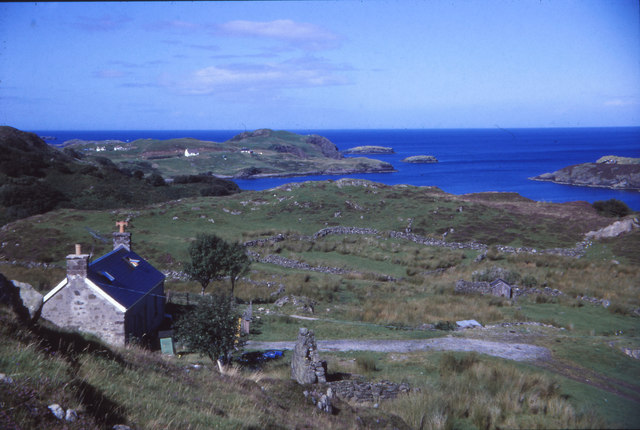
Loch Nedd is a picturesque body of water located in the county of Sutherland, in the northwestern part of Scotland. It is a sea loch or inlet, formed by the ocean's incursion into the surrounding land. The loch is situated on the west coast of Sutherland, near the village of Drumbeg.

With its stunning natural beauty, Loch Nedd offers a tranquil and idyllic setting for visitors and locals alike. The loch spans approximately 4 miles in length and varies in width, reaching up to 1 mile at its widest point. Its deep, clear waters are surrounded by rolling hills and rugged cliffs, providing a dramatic backdrop to the scenery.

The loch is an estuary, which means that it is influenced by both freshwater and saltwater. The freshwater rivers and streams that flow into Loch Nedd contribute to the loch's diverse ecosystem, supporting a variety of plant and animal life. The surrounding vegetation consists of lush greenery, including heather and grasses, which provide a habitat for numerous bird species.

Loch Nedd is also known for its rich marine life, with an abundance of fish and shellfish species inhabiting its waters. Fishing enthusiasts can enjoy a day out on the loch, casting their lines for salmon, sea trout, and brown trout, among others.

The loch is accessible by road, and there are several viewpoints and picnic areas along its shores, allowing visitors to take in the breathtaking views. Loch Nedd is a popular destination for nature lovers, photographers, and those seeking a peaceful retreat in the heart of the Scottish Highlands.

If you have any feedback on the listing, please let us know in the comments section below.

Loch Nedd Images

Images are sourced within 2km of 58.244256/-5.1712906 or Grid Reference NC1332. Thanks to Geograph Open Source API. All images are credited.

Drumbeg stores. Packed full of goodies.
Drumbeg stores.
Packed full of goodies.
Main road through Drumbeg
Road on Outskirts of Drumbeg
Drumbeg Public Conveniences
Drumbeg - Various Buildings Some sign of derelict farm buildings.
Drumbeg - Various Buildings
Some sign of derelict farm buildings.
View of Eilean an Achaidh Viewing station for the Loch Dhrombaig and Islands.
View of Eilean an Achaidh
Viewing station for the Loch Dhrombaig and Islands.
Loch Dhrombaig From Drumbeg towards Loch Dhrombaig and Culkein Drumbeg
Loch Dhrombaig
From Drumbeg towards Loch Dhrombaig and Culkein Drumbeg
Drumbeg Drumbeg village towards Sail Gorm and Quinag
Drumbeg
Drumbeg village towards Sail Gorm and Quinag
Boats on Loch Nedd A sheltered sea loch with boats at their moorings.
Boats on Loch Nedd
A sheltered sea loch with boats at their moorings.
Tidal waters, Loch Nedd The view towards the head of this sea loch with Quinag dominating the skyline.
Tidal waters, Loch Nedd
The view towards the head of this sea loch with Quinag dominating the skyline.
The road through Nedd Nedd is a tiny settlement on the twisting B869 about a mile east of Drumbeg. The view here includes the north western 'wing' of Quinag.
The road through Nedd
Nedd is a tiny settlement on the twisting B869 about a mile east of Drumbeg. The view here includes the north western 'wing' of Quinag.
A useful facility when there's no mobile signal A telephone kiosk in Nedd. The sheltered position of this tiny settlement means that the door has not been blown away, but the kiosk is in need of a lick of paint. In summer this could be a useful refuge from midges.
A useful facility when there's no mobile signal
A telephone kiosk in Nedd. The sheltered position of this tiny settlement means that the door has not been blown away, but the kiosk is in need of a lick of paint. In summer this could be a useful refuge from midges.
Drumbeg Stores An award winning village shop [beyond the white house] with slightly less range of foods than M&S in Inverness, but the Mull cheese is very acceptable.
Drumbeg Stores
An award winning village shop [beyond the white house] with slightly less range of foods than M&S in Inverness, but the Mull cheese is very acceptable.
Downtown Drumbeg The village shop and the hotel are both to the left of the road, which through the village has a 30mph limit, unlike the rest of the B869 where 20mph is more likely the average speed.
Downtown Drumbeg
The village shop and the hotel are both to the left of the road, which through the village has a 30mph limit, unlike the rest of the B869 where 20mph is more likely the average speed.
Loo with a view in Drumbeg One could compile an album of 'loos with views' in the NW Highlands. This particular convenience overlooks Eddrachillis Bay.
Loo with a view in Drumbeg
One could compile an album of 'loos with views' in the NW Highlands. This particular convenience overlooks Eddrachillis Bay.
Tin roofed byre, Drumbeg Standing on the hillside above Eddrachillis Bay and with a view towards Arkle.
Tin roofed byre, Drumbeg
Standing on the hillside above Eddrachillis Bay and with a view towards Arkle.
A pattern of islands The view from the viewpoint in Drumbeg. Eilean Dubh Chal Cinn to the left, Eilean Dubh Dhrombaig to the right (both <a href="https://www.geograph.org.uk/gridref/NC1334">NC1334</a>). In the distance Meall Mòr and Meall Beag (both <a href="https://www.geograph.org.uk/gridref/NC1338">NC1338</a>).
A pattern of islands
The view from the viewpoint in Drumbeg. Eilean Dubh Chal Cinn to the left, Eilean Dubh Dhrombaig to the right (both NC1334). In the distance Meall Mòr and Meall Beag (both NC1338).
Drumbeg viewpoint Commanding an astonishing view of the coast and islands to the north.
Drumbeg viewpoint
Commanding an astonishing view of the coast and islands to the north.
Show me another place!

Loch Nedd is located at Grid Ref: NC1332 (Lat: 58.244256, Lng: -5.1712906)

Unitary Authority: Highland

Police Authority: Highlands and Islands

What 3 Words

///linguists.treaty.push. Near Clachtoll, Highland

Nearby Locations

Meall nan Each Loch Nedd

Related Wikis

Nedd

Nedd (Scottish Gaelic: An Nead) is a small village, which lies on the western head of Loch Nedd in Lairg, western Sutherland, Scottish Highlands and is...
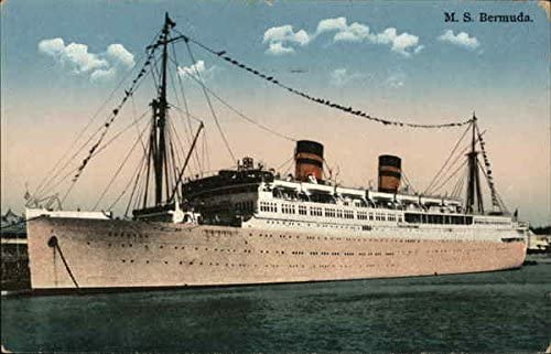
MV Bermuda

MV Bermuda was a passenger motor ship that Furness, Withy's Furness Bermuda Line operated between New York and Bermuda from 1928 until 1931. She was damaged...

Drumbeg, Sutherland

Drumbeg (Scottish Gaelic: An Druim Beag) is a remote crofting village on the north west coast of Scotland in Assynt, Sutherland, Scottish Highlands and...

Culkein Drumbeg

Culkein Drumbeg (Scottish Gaelic: Cùl-cinn an Droma Bhig) is a remote village on the north west coast of Scotland. It is located 0.93 miles (1.50 km) north...

Nearby Amenities

Located within 500m of 58.244256,-5.1712906
Source: PGS
Lat/Long: 58.2485329/-5.170693
Source: PGS
Lat/Long: 58.2479994/-5.172797
Source: PGS
Lat/Long: 58.2475844/-5.1724912
Source: PGS
Lat/Long: 58.2473501/-5.172109
Source: PGS
Lat/Long: 58.2470603/-5.1717725
Source: PGS
Lat/Long: 58.2466551/-5.1717711
Source: PGS
Lat/Long: 58.2460881/-5.1713224
Source: PGS
Lat/Long: 58.2461594/-5.1705641
Source: PGS
Lat/Long: 58.2461617/-5.1696636
Source: PGS
Lat/Long: 58.2460849/-5.1682623
Created By: almien_coastlines
Source: PGS
Lat/Long: 58.245963/-5.16837
Source: PGS
Lat/Long: 58.2455718/-5.1684801
Source: PGS
Lat/Long: 58.2450361/-5.167747
Source: PGS
Lat/Long: 58.2446451/-5.1687498
Source: PGS
Lat/Long: 58.2442739/-5.1692241
Source: PGS
Lat/Long: 58.243846/-5.1695251
Source: PGS
Lat/Long: 58.243418/-5.1703289
Created By: almien_coastlines
Source: PGS
Lat/Long: 58.243108/-5.170623
Source: PGS
Lat/Long: 58.2426858/-5.1707818
Source: PGS
Lat/Long: 58.2424373/-5.1709313
Source: PGS
Lat/Long: 58.241976/-5.1729001
Source: PGS
Lat/Long: 58.2417938/-5.1732105
Source: PGS
Lat/Long: 58.241555/-5.1731846
Source: PGS
Lat/Long: 58.2409686/-5.1725214
Source: PGS
Lat/Long: 58.2405915/-5.1721283
Source: PGS
Lat/Long: 58.2405672/-5.1710261
Source: PGS
Lat/Long: 58.2405809/-5.1706941
Created By: almien_coastlines
Source: PGS
Lat/Long: 58.24055/-5.170467
Source: PGS
Lat/Long: 58.2416299/-5.1758269
Source: PGS
Lat/Long: 58.2417806/-5.1757792
Source: PGS
Lat/Long: 58.2431514/-5.1755126
Source: PGS
Lat/Long: 58.2437088/-5.1761016
Source: PGS
Lat/Long: 58.2446444/-5.1753506
Source: PGS
Lat/Long: 58.2451633/-5.175983
Source: PGS
Lat/Long: 58.2452576/-5.1767094
Source: PGS
Lat/Long: 58.2457209/-5.1761305
Source: PGS
Lat/Long: 58.246106/-5.1767244
Source: PGS
Lat/Long: 58.2468891/-5.1768199
Source: PGS
Lat/Long: 58.2469275/-5.1770194
Source: PGS
Lat/Long: 58.2469625/-5.1779609
The data included in this document is from www.openstreetmap.org. The data is made available under ODbL.

Have you been to Loch Nedd?

Leave your review of Loch Nedd below (or comments, questions and feedback).