Port Faoileann a' Chlachanaich

Sea, Estuary, Creek in Argyllshire

Scotland

Port Faoileann a' Chlachanaich

Ardalanish Bay The west end of the kilometre-long stretch of sand.
Ardalanish Bay Credit: Anne Burgess

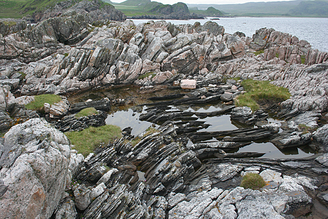
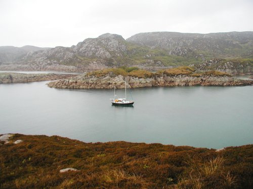
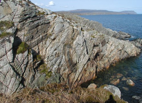
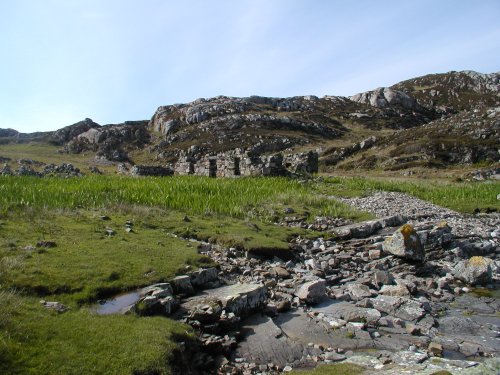
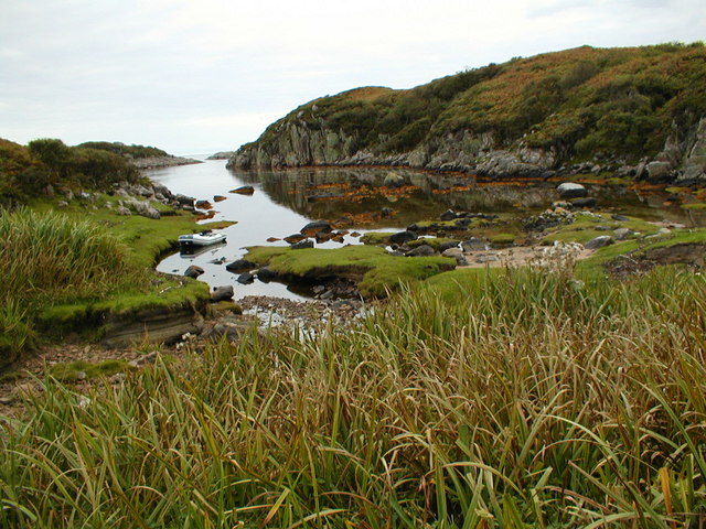
Port Faoileann a' Chlachanaich is a picturesque coastal area located in Argyllshire, Scotland. Nestled amidst the natural beauty of the region, it is renowned for its stunning sea, estuary, and creek. The name "Port Faoileann a' Chlachanaich" translates to "Port of Seagulls and Rocks" in Gaelic, which perfectly encapsulates the essence of this serene location.

The sea at Port Faoileann a' Chlachanaich boasts crystal clear waters that shimmer under the sunlight. It is a haven for marine enthusiasts, offering opportunities for swimming, snorkeling, and diving. The sea is also home to a diverse range of marine life, including seals, dolphins, and various species of fish.

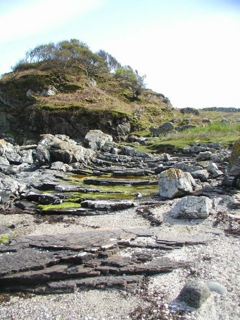
The estuary at Port Faoileann a' Chlachanaich is formed by the convergence of a river and the sea. This unique ecosystem supports a rich biodiversity, attracting numerous bird species, including seagulls, herons, and cormorants. Birdwatchers can spot these magnificent creatures in their natural habitat, soaring above the estuary.

A creek meanders through the landscape, adding to the charm of Port Faoileann a' Chlachanaich. Surrounded by lush greenery, the creek is a tranquil spot for nature lovers to explore. Visitors can take leisurely walks along its banks, immersing themselves in the peaceful ambiance and enjoying the soothing sounds of flowing water.

With its stunning sea, estuary, and creek, Port Faoileann a' Chlachanaich offers a perfect blend of natural beauty and tranquility. Whether you seek adventure in the sea, observe birdlife in the estuary, or simply unwind by the creek, this coastal area is sure to leave visitors captivated by its breathtaking scenery.

If you have any feedback on the listing, please let us know in the comments section below.

Port Faoileann a' Chlachanaich Images

Images are sourced within 2km of 56.270431/-6.2594073 or Grid Reference NM3616. Thanks to Geograph Open Source API. All images are credited.

Ardalanish Bay The west end of the kilometre-long stretch of sand.
Ardalanish Bay
The west end of the kilometre-long stretch of sand.
Boulders by the Track The large boulder may be an erratic, but the smaller ones seem to have been arranged in a straight line. In the distance is Loch Mòr Ardalanish in the next square.
Boulders by the Track
The large boulder may be an erratic, but the smaller ones seem to have been arranged in a straight line. In the distance is Loch Mòr Ardalanish in the next square.
Cordierite The dark shapes on the surface of the rock are cordierite crystals. This is an  indicator mineral, so called because it forms in particular conditions of heat and pressure, so its presence tells geologists part of the history of the rock.
Cordierite
The dark shapes on the surface of the rock are cordierite crystals. This is an indicator mineral, so called because it forms in particular conditions of heat and pressure, so its presence tells geologists part of the history of the rock.
Carraig Mhòr The west side of Ardalanish Bay is on the fringe of the pink Ross of Mull granite intrusion. This is the eastern edge, and possibly the bottom, of the granite, which is sheet-like in form and anything from 2 to 8 kilometres thick. It may have made its way in via what is now the Sound of Iona Fault. it is interfingered here with grey Moine psammites.
Carraig Mhòr
The west side of Ardalanish Bay is on the fringe of the pink Ross of Mull granite intrusion. This is the eastern edge, and possibly the bottom, of the granite, which is sheet-like in form and anything from 2 to 8 kilometres thick. It may have made its way in via what is now the Sound of Iona Fault. it is interfingered here with grey Moine psammites.
Carraig Mhòr The dark grey rocks are Moine psammites which have been deformed and contorted by the intruding pink Ross of Mull granite.
Carraig Mhòr
The dark grey rocks are Moine psammites which have been deformed and contorted by the intruding pink Ross of Mull granite.
Carraig Mhòr The dark layers at the top and bottom of this outcrop are Moine psammites, that is, metamorphosed sandstones. Between them is a thick sheet of bright pink Ross of Mull granite. 

The granite can be dated by radiometric methods, and is found to have been intruded about 414 million years ago. Because the granite cuts through the Moine rocks, it must be younger than they are, so it provides evidence for the age of the Moine. 

Inside the granite sheet are xenoliths of Moine rock. A xenolith is a pre-existing piece or rock which has got caught up in a magma body. 

Finally, a thick dark sheet of microdiorite cuts diagonally across both the granite and the xenoliths. This is obviously later than the rocks it cuts through, and such microdiorite intrusions are possibly the final phase in the evolution of the granite complex. 

Diorite is chemically intermediate between gabbro and granite, and microdiorite is finer-grained than diorite because it has cooled faster. A magma of dioritic chemical composition, if erupted at the surface of the Earth, forms andesite, so named because of its prevalence in the South American Andes.
Carraig Mhòr
The dark layers at the top and bottom of this outcrop are Moine psammites, that is, metamorphosed sandstones. Between them is a thick sheet of bright pink Ross of Mull granite. The granite can be dated by radiometric methods, and is found to have been intruded about 414 million years ago. Because the granite cuts through the Moine rocks, it must be younger than they are, so it provides evidence for the age of the Moine. Inside the granite sheet are xenoliths of Moine rock. A xenolith is a pre-existing piece or rock which has got caught up in a magma body. Finally, a thick dark sheet of microdiorite cuts diagonally across both the granite and the xenoliths. This is obviously later than the rocks it cuts through, and such microdiorite intrusions are possibly the final phase in the evolution of the granite complex. Diorite is chemically intermediate between gabbro and granite, and microdiorite is finer-grained than diorite because it has cooled faster. A magma of dioritic chemical composition, if erupted at the surface of the Earth, forms andesite, so named because of its prevalence in the South American Andes.
Rocky point on West edge of Ardanalish Bay
Beinn a'Chaol-airigh Walked along the track through the organic farm with the Highland cows and Hebridean sheep on a wet day with Jim Bloomer. Summit is just rather flat and featureless moorland.
Name: Beinn a'Chaol-airigh
Hill number: 4813
Height: 127m / 417ft
Area: 17E: Mull and Nearby Islands
Class: Hu,1
Grid ref: NM 35511 18443
Summit feature: no feature
Drop: 103m
Col: 24m  NM406197
Beinn a'Chaol-airigh
Walked along the track through the organic farm with the Highland cows and Hebridean sheep on a wet day with Jim Bloomer. Summit is just rather flat and featureless moorland. Name: Beinn a'Chaol-airigh Hill number: 4813 Height: 127m / 417ft Area: 17E: Mull and Nearby Islands Class: Hu,1 Grid ref: NM 35511 18443 Summit feature: no feature Drop: 103m Col: 24m NM406197
Cattle Grazing Highland Cattle on rough moorland grazing seen walking towards Beinn a'Chaol-airigh.
Cattle Grazing
Highland Cattle on rough moorland grazing seen walking towards Beinn a'Chaol-airigh.
The anchorage at  Rubh  Ardalanish A wild, remote spot on the Ross of Mull. The rock here is all granite but nearby there is metamorphic rock where garnets can be found on the beach. A lonely place now but there is much of evidence of former habitation around the bay.
The anchorage at Rubh Ardalanish
A wild, remote spot on the Ross of Mull. The rock here is all granite but nearby there is metamorphic rock where garnets can be found on the beach. A lonely place now but there is much of evidence of former habitation around the bay.
Rubh' Ardalanish Some interesting geology here - this part of the Headland of Rubh' Ardalanish is in the contact zone between the Ross of Mull granite to the west and an area of schist to the east. The landscape is rugged and spectacular. Remote now, there is much evidence of former habitation.
Rubh' Ardalanish
Some interesting geology here - this part of the Headland of Rubh' Ardalanish is in the contact zone between the Ross of Mull granite to the west and an area of schist to the east. The landscape is rugged and spectacular. Remote now, there is much evidence of former habitation.
Xenoliths The patches of darker rock set into the pinkish Ross of Mull granite are 'Xenoliths' - lumps of the surrounding rock which broke off and fell into the molten granite while it was deep underground. It has since solidified and been exposed on the surface by erosion.
Xenoliths
The patches of darker rock set into the pinkish Ross of Mull granite are 'Xenoliths' - lumps of the surrounding rock which broke off and fell into the molten granite while it was deep underground. It has since solidified and been exposed on the surface by erosion.
Ruined Cottage A sad reminder that people once lived and worked in this beautiful place. There are piles of stones cleared from the ground to show that the land was cultivated and several other cottages in the vicinity saying that it was a good place to make a living.
Ruined Cottage
A sad reminder that people once lived and worked in this beautiful place. There are piles of stones cleared from the ground to show that the land was cultivated and several other cottages in the vicinity saying that it was a good place to make a living.
Creek north of Rubh Ardalanish Coastal land between Torr na Sealga and Beinn a Chaol-airigh to the north of the anchorage on Rubh Ardalanish
Creek north of Rubh Ardalanish
Coastal land between Torr na Sealga and Beinn a Chaol-airigh to the north of the anchorage on Rubh Ardalanish
Cnoc Mor near Ardalanish
Tràigh Gheal The climb out of Tràigh Gheal. Not too bad so far but soon fighting through bracken, bog myrtle and sage scrub.
Tràigh Gheal
The climb out of Tràigh Gheal. Not too bad so far but soon fighting through bracken, bog myrtle and sage scrub.
View to Beinn Cholarich From Dun nan Torran looking back to the Tireragan estate to see if there was a better way. No path was found and we were faced with fighting through scrub of bracken, bog myrtle and sage.
View to Beinn Cholarich
From Dun nan Torran looking back to the Tireragan estate to see if there was a better way. No path was found and we were faced with fighting through scrub of bracken, bog myrtle and sage.
View to Aird Dhughaill From Dun nan Torran looking back to the Tireragan estate to see if there was a better way. No path was found and we were faced with fighting through scrub of bracken, bog myrtle and sage.
View to Aird Dhughaill
From Dun nan Torran looking back to the Tireragan estate to see if there was a better way. No path was found and we were faced with fighting through scrub of bracken, bog myrtle and sage.
Show me another place!

Port Faoileann a' Chlachanaich is located at Grid Ref: NM3616 (Lat: 56.270431, Lng: -6.2594073)

Unitary Authority: Argyll and Bute

Police Authority: Argyll and West Dunbartonshire

What 3 Words

///outsize.define.flagging. Near Fionnphort, Argyll & Bute

Related Wikis

Ardalanish

Ardalanish (Scottish Gaelic: Àird Dealanais) is a village on the Isle of Mull in Argyll and Bute, Scotland. It is now an organic farm and weaving mill...

Knocknafenaig

Knocknafenaig (Scottish Gaelic: Cnoc na Fennaig) is a ruined township on the Isle of Mull, Scotland. Located in the south-western portion of the island...

Uisken

Uisken (Scottish Gaelic: Uisgean, meaning "water-bay") is a settlement on a sandy bay on the Ross of Mull in the south of the Isle of Mull, on the west...

Ross of Mull

The Ross of Mull (Scottish Gaelic: An Ros Mhuileach) is the largest peninsula of the Isle of Mull, about 28 kilometres (17 mi) long, and makes up the south...

Nearby Amenities

Located within 500m of 56.270431,-6.2594073
Source: PGS
Lat/Long: 56.2744027/-6.2558854
Source: PGS
Lat/Long: 56.2742228/-6.256454
Source: PGS
Lat/Long: 56.2739121/-6.2569154
Source: PGS
Lat/Long: 56.2739601/-6.2573016
Source: PGS
Lat/Long: 56.2737334/-6.25772
Source: PGS
Lat/Long: 56.2738543/-6.2585918
Source: PGS
Lat/Long: 56.2732628/-6.2588573
Source: PGS
Lat/Long: 56.2734752/-6.2574615
Source: PGS
Lat/Long: 56.2730141/-6.2576304
Created By: dmgroom_coastlines
Source: PGS
Lat/Long: 56.27303/-6.25826
Created By: dmgroom_coastlines
Source: PGS
Lat/Long: 56.27291/-6.2585
Created By: dmgroom_coastlines
Source: PGS
Lat/Long: 56.27265/-6.25851
Source: PGS
Lat/Long: 56.2728026/-6.2578381
Source: PGS
Lat/Long: 56.2723832/-6.2576235
Source: PGS
Lat/Long: 56.2713601/-6.2580553
Source: PGS
Lat/Long: 56.2710863/-6.2583042
Source: PGS
Lat/Long: 56.2709741/-6.2587849
Source: PGS
Lat/Long: 56.2708868/-6.2592274
Created By: dmgroom_coastlines
Source: PGS
Lat/Long: 56.27079/-6.2595
Created By: dmgroom_coastlines
Source: PGS
Lat/Long: 56.27078/-6.26072
Source: PGS
Lat/Long: 56.2706282/-6.2623565
Created By: dmgroom_coastlines
Source: PGS
Lat/Long: 56.27043/-6.26213
Created By: dmgroom_coastlines
Source: PGS
Lat/Long: 56.27026/-6.2603
Source: PGS
Lat/Long: 56.2700221/-6.2596512
Created By: dmgroom_coastlines
Source: PGS
Lat/Long: 56.26984/-6.25872
Created By: dmgroom_coastlines
Source: PGS
Lat/Long: 56.26972/-6.25895
Created By: dmgroom_coastlines
Source: PGS
Lat/Long: 56.26959/-6.25919
Source: PGS
Lat/Long: 56.2692255/-6.2590826
Source: PGS
Lat/Long: 56.2685723/-6.2595869
Created By: dmgroom_coastlines
Source: PGS
Lat/Long: 56.26847/-6.26042
Created By: dmgroom_coastlines
Source: PGS
Lat/Long: 56.2686/-6.26065
Source: PGS
Lat/Long: 56.26925/-6.2601233
Source: PGS
Lat/Long: 56.2687412/-6.2610567
Source: PGS
Lat/Long: 56.268961/-6.2628833
Created By: dmgroom_coastlines
Source: PGS
Lat/Long: 56.26812/-6.26206
Source: PGS
Lat/Long: 56.2674954/-6.2625764
Created By: dmgroom_coastlines
Source: PGS
Lat/Long: 56.2675/-6.26325
Source: PGS
Lat/Long: 56.2677114/-6.2647823
Source: PGS
Lat/Long: 56.2675463/-6.2647812
Created By: dmgroom_coastlines
Source: PGS
Lat/Long: 56.26726/-6.26373
Created By: dmgroom_coastlines
Source: PGS
Lat/Long: 56.26711/-6.26282
Source: PGS
Lat/Long: 56.2667792/-6.2629096
The data included in this document is from www.openstreetmap.org. The data is made available under ODbL.

Have you been to Port Faoileann a' Chlachanaich?

Leave your review of Port Faoileann a' Chlachanaich below (or comments, questions and feedback).