Llaneglwys

Settlement in Brecknockshire

Wales

Llaneglwys

Ordnance Survey Cut Mark This OS cut mark can be found on the culvert east side of the road. It marks a point 306.882m above mean sea level.
Ordnance Survey Cut Mark Credit: Adrian Dust

The requested URL returned error: 429 Too Many Requests

If you have any feedback on the listing, please let us know in the comments section below.
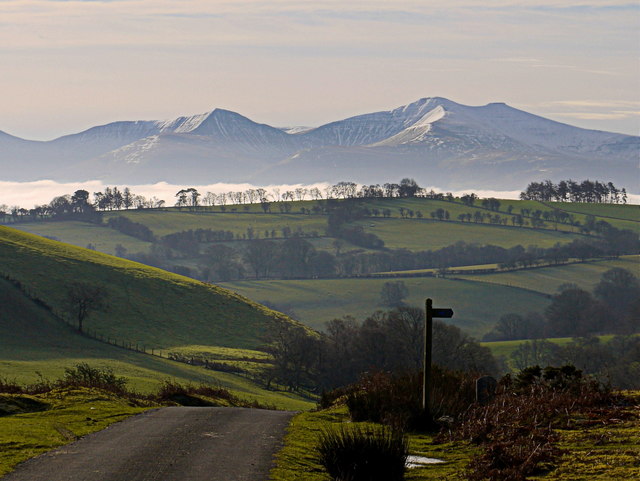
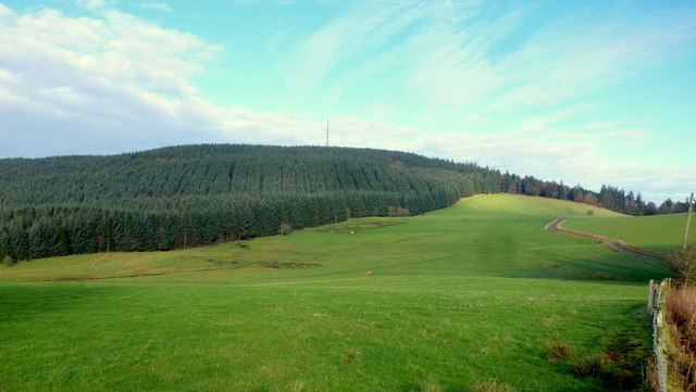
Llaneglwys Images

Images are sourced within 2km of 52.038728/-3.366779 or Grid Reference SO0638. Thanks to Geograph Open Source API. All images are credited.

Ordnance Survey Cut Mark This OS cut mark can be found on the culvert east side of the road. It marks a point 306.882m above mean sea level.
Ordnance Survey Cut Mark
This OS cut mark can be found on the culvert east side of the road. It marks a point 306.882m above mean sea level.
Old forestry watch tower beside radio mast Recent clear felling in Brycheiniog Forest has made visible the watch tower for fires which the Forestry Commission erected long before the radio mast was constructed. It was still being used in the late 1950s.
Old forestry watch tower beside radio mast
Recent clear felling in Brycheiniog Forest has made visible the watch tower for fires which the Forestry Commission erected long before the radio mast was constructed. It was still being used in the late 1950s.
Rounding up sheep Two Welsh collies, a landrover, and a very experienced farmer - a familiar sight across Brecknock and Mid Wales.
Rounding up sheep
Two Welsh collies, a landrover, and a very experienced farmer - a familiar sight across Brecknock and Mid Wales.
Road on Llandyfalle Hill Unfenced country road across common land on Llandyfalle Hill, the Brecon Beacons can be seen on the horizon.
Road on Llandyfalle Hill
Unfenced country road across common land on Llandyfalle Hill, the Brecon Beacons can be seen on the horizon.
Werntoe Crossroads Pictured from the northern extremity of Llandefalle Common.
Werntoe Crossroads
Pictured from the northern extremity of Llandefalle Common.
On Llandyfalle Hill, 1 Looking west towards the mast on Ysgwydd Hwch in Brycheiniog Forest.
On Llandyfalle Hill, 1
Looking west towards the mast on Ysgwydd Hwch in Brycheiniog Forest.
On Llandyfalle Hill, 2 Looking towards the forested crest of this common land.
On Llandyfalle Hill, 2
Looking towards the forested crest of this common land.
View from Llandyfalle Hill, 1 In the foreground is the open moorland of llandefalle Common.
the farmland in the centre ground covers the upper reaches of the Dulas with sheep pasture dotted with woodland.
Beyond the Twyn-y-gaer ridge there is a glimpse of the temperature-inversion cloud filling the Usk valley around Brecon.
Crowning this view are the three main peaks of the Beacons; Cribyn, Pen y Fan and Corn Du.
View from Llandyfalle Hill, 1
In the foreground is the open moorland of llandefalle Common. the farmland in the centre ground covers the upper reaches of the Dulas with sheep pasture dotted with woodland. Beyond the Twyn-y-gaer ridge there is a glimpse of the temperature-inversion cloud filling the Usk valley around Brecon. Crowning this view are the three main peaks of the Beacons; Cribyn, Pen y Fan and Corn Du.
View from Llandyfalle Hill, 2 In the foreground is the open moorland of llandefalle Common.
the farmland in the centre ground covers the upper reaches of the Dulas with sheep pasture dotted with woodland.
Beyond the Twyn-y-gaer ridge there is a glimpse of the temperature-inversion cloud filling the Usk valley around Brecon.
Crowning this view are the three main peaks of the Beacons; Cribyn, Pen y Fan and Corn Du.
View from Llandyfalle Hill, 2
In the foreground is the open moorland of llandefalle Common. the farmland in the centre ground covers the upper reaches of the Dulas with sheep pasture dotted with woodland. Beyond the Twyn-y-gaer ridge there is a glimpse of the temperature-inversion cloud filling the Usk valley around Brecon. Crowning this view are the three main peaks of the Beacons; Cribyn, Pen y Fan and Corn Du.
Bridleway signpost, Llandyfalle Hill In the foreground is the open moorland of Llandefalle Common.
The farmland in the centre ground covers the upper reaches of the Dulas with sheep pasture dotted with woodland.
Beyond the Twyn-y-gaer ridge there is a glimpse of the temperature-inversion cloud filling the Usk valley around Brecon.
Crowning this view are the three main peaks of the Beacons; Cribyn, Pen y Fan and Corn Du.
Bridleway signpost, Llandyfalle Hill
In the foreground is the open moorland of Llandefalle Common. The farmland in the centre ground covers the upper reaches of the Dulas with sheep pasture dotted with woodland. Beyond the Twyn-y-gaer ridge there is a glimpse of the temperature-inversion cloud filling the Usk valley around Brecon. Crowning this view are the three main peaks of the Beacons; Cribyn, Pen y Fan and Corn Du.
Bridleway on Llandefalle Common In the distance is the Black Mountains scarp.
Bridleway on Llandefalle Common
In the distance is the Black Mountains scarp.
Ysgwydd Hwch At 456m we have the highest point of the Llandefalle plateau. Completely clothed in the dark conifers of the Brycheiniog Forest and topped by a communications mast.
Ysgwydd Hwch
At 456m we have the highest point of the Llandefalle plateau. Completely clothed in the dark conifers of the Brycheiniog Forest and topped by a communications mast.
Edge of Brycheiniog Forest A beech edge to the pasture gives way to conifers for most of the woodland.
Edge of Brycheiniog Forest
A beech edge to the pasture gives way to conifers for most of the woodland.
Frozen forest track Leading downhill through a deciduous section of Brycheiniog Forest.
Frozen forest track
Leading downhill through a deciduous section of Brycheiniog Forest.
Road through Brycheiniog Forest Heading north through mixed woodland towards Llaneglwys.
Road through Brycheiniog Forest
Heading north through mixed woodland towards Llaneglwys.
Conifers in Brycheiniog Forest Looking at right angles to the right of <a href="https://www.geograph.org.uk/photo/4801133">SO0538 : Road through Brycheiniog Forest</a>.
Conifers in Brycheiniog Forest
Looking at right angles to the right of SO0538 : Road through Brycheiniog Forest.
Houses at Llaneglwys This small community occupies a position in a valley bottom almost completely surrounded by the Brycheiniog Forest.
Houses at Llaneglwys
This small community occupies a position in a valley bottom almost completely surrounded by the Brycheiniog Forest.
Telephone box at Llaneglwys Positioned by the river but seemingly well looked-after.
Telephone box at Llaneglwys
Positioned by the river but seemingly well looked-after.
Show me another place!

Llaneglwys is located at Grid Ref: SO0638 (Lat: 52.038728, Lng: -3.366779)

Unitary Authority: Powys

Police Authority: Dyfed Powys

What 3 Words

///submitted.gullible.donates. Near Brecon, Powys

Related Wikis

Mynydd Fforest

Mynydd Fforest (Forested Mountain) is a hill about two miles northwest of Llyswen in the county of Powys in Wales. It rises to 400 m (1312 ft) from the...

Castell Madoc

Castell Madoc is a small rural village in Brecon, Powys. The village lies next to Mynydd Epynt, on Afon Honddu, one of the most important tributaries of...

Honddu Isaf

Honddu Isaf is a community in Powys, situated immediately to the north of Brecon on either side of the B4520 road to Builth Wells. It is in the historic...

Erwood

Erwood (Welsh: Erwyd) is a village and community lying beside the River Wye, on the A470 road some 6 miles south-east of Builth Wells in Powys, Wales....

Nearby Amenities

Located within 500m of 52.038728,-3.366779
Llaneglwys
Place: village
Wikidata: Q20593791
Lat/Long: 52.0382127/-3.3699947
Post Box
Post Box Type: lamp
Lat/Long: 52.0382481/-3.3707535
Telephone
Booth: K6
Covered: booth
Operator: BT
Phone: +44 1982 560664
Lat/Long: 52.0381434/-3.3705416
The data included in this document is from www.openstreetmap.org. The data is made available under ODbL.

Have you been to Llaneglwys?

Leave your review of Llaneglwys below (or comments, questions and feedback).