St John's Haven

Sea, Estuary, Creek in Northumberland

England

St John's Haven

Beach at Sharper's Head, North of Berwick Access down to the beach from the Caravan Park at Sharper's Head.
Beach at Sharper's Head, North of Berwick Credit: Lisa Jarvis

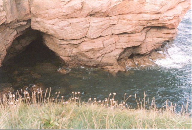
St John's Haven, located in Northumberland, is a picturesque coastal area known for its stunning sea, estuary, and creek. Situated along the North Sea, this haven offers a diverse range of natural beauty and recreational opportunities.

The sea at St John's Haven is renowned for its breathtaking views and tranquil atmosphere. Visitors can enjoy long walks along the sandy beaches, taking in the fresh salty air and listening to the calming sound of waves crashing against the shore. The sea provides ample opportunities for water-based activities such as swimming, surfing, and fishing.

Adjacent to the sea is a beautiful estuary, where the river meets the sea. This area is a haven for birdwatchers and nature enthusiasts. The estuary is home to a wide variety of bird species, making it a popular spot for birdwatching and photography. Visitors can observe migratory birds, wading birds, and waterfowl in their natural habitat.

A creek also flows through St John's Haven, offering a serene and peaceful setting. The creek is surrounded by lush greenery and provides a perfect spot for boating and kayaking. Exploring the creek allows visitors to immerse themselves in the natural beauty of the area, with opportunities to spot local wildlife and enjoy the tranquility of the water.

Overall, St John's Haven in Northumberland is a coastal gem, boasting a stunning sea, estuary, and creek. It offers a wide range of activities for nature lovers, beach enthusiasts, and those seeking a peaceful retreat in a picturesque setting.

If you have any feedback on the listing, please let us know in the comments section below.

St John's Haven Images

Images are sourced within 2km of 55.797445/-2.0160681 or Grid Reference NT9956. Thanks to Geograph Open Source API. All images are credited.

Beach at Sharper's Head, North of Berwick Access down to the beach from the Caravan Park at Sharper's Head.
Beach at Sharper's Head, North of Berwick
Access down to the beach from the Caravan Park at Sharper's Head.
Beach at Sharper's Head, North of Berwick Access to the beach from the caravan park at Sharper's Head.
Beach at Sharper's Head, North of Berwick
Access to the beach from the caravan park at Sharper's Head.
Cliffs, Sharper's Head, North of Berwick Craggy cliffs with numerous caves north of Berwick-upon-Tweed. There is the remains of a building of some sort in the foreground.
Cliffs, Sharper's Head, North of Berwick
Craggy cliffs with numerous caves north of Berwick-upon-Tweed. There is the remains of a building of some sort in the foreground.
Cliffs from Berwickshire Coastal path Craggy cliffs and caves
Cliffs from Berwickshire Coastal path
Craggy cliffs and caves
Brotherston's Hole, North of Berwick-upon-Tweed
Caves, near Shaper's Head There are a number of caves in the cliffs north of Berwick-upon-Tweed.
Caves, near Shaper's Head
There are a number of caves in the cliffs north of Berwick-upon-Tweed.
Oystercatchers on the Tee At Magdalene Fields Golf Course, Berwick-upon-Tweed.
Oystercatchers on the Tee
At Magdalene Fields Golf Course, Berwick-upon-Tweed.
Brotherston's Hole in the Cliffs north of Berwick-on-Tweed
Cliffs at Magdalene Fields Viewed from the Berwickshire Coast Path at Sharper's Head.
Cliffs at Magdalene Fields
Viewed from the Berwickshire Coast Path at Sharper's Head.
Be careful now! A parent watches her children scramble up the lower section of the cliffs at Magdalene Fields to the north of Berwick Holiday Park.
Be careful now!
A parent watches her children scramble up the lower section of the cliffs at Magdalene Fields to the north of Berwick Holiday Park.
A seaside adventure This family group are edging their way along the foot of the cliffs at Magdalene Fields at low tide. The exploration began with the young boy on the right, then the two girls, and eventually the mother was persuaded to join in the seaside scramble.
A seaside adventure
This family group are edging their way along the foot of the cliffs at Magdalene Fields at low tide. The exploration began with the young boy on the right, then the two girls, and eventually the mother was persuaded to join in the seaside scramble.
Is anybody in there? There are several caves along the foot of the cliffs at Magdalene Fields on the north side of Berwick-upon-Tweed. A low tide had allowed this youngster to wade across some large rock pools and gain entry to the mouth of the cave. I could sense his feeling of excitement and adventure as he gazed into the darkness of this natural hollow.
Is anybody in there?
There are several caves along the foot of the cliffs at Magdalene Fields on the north side of Berwick-upon-Tweed. A low tide had allowed this youngster to wade across some large rock pools and gain entry to the mouth of the cave. I could sense his feeling of excitement and adventure as he gazed into the darkness of this natural hollow.
The shore to the north of Berwick Holiday Park Low tide between Sharper's Head and Brotherston's Hole on the north side of Berwick-upon-Tweed. A youngster centre left is exploring the rock pools at the foot of the cliffs.
The shore to the north of Berwick Holiday Park
Low tide between Sharper's Head and Brotherston's Hole on the north side of Berwick-upon-Tweed. A youngster centre left is exploring the rock pools at the foot of the cliffs.
Looking into a sea cave at Dod’s Well There are several sea caves which can be explored at low tide along the foot of the cliffs at Magdalene Fields on the north side of Berwick-upon-Tweed.
Looking into a sea cave at Dod’s Well
There are several sea caves which can be explored at low tide along the foot of the cliffs at Magdalene Fields on the north side of Berwick-upon-Tweed.
A dead guillemot at Dod’s Well Several sea birds were washed up on the Northumberland coastline after a couple of days of rough sea conditions.
A dead guillemot at Dod’s Well
Several sea birds were washed up on the Northumberland coastline after a couple of days of rough sea conditions.
Light and shade in a sea cave For a view of the entrance to the cave at the foot of the cliffs at Magdalene Fields, see <a href="https://www.geograph.org.uk/photo/1534066">NU0054 : Is anybody in there?</a>.
Light and shade in a sea cave
For a view of the entrance to the cave at the foot of the cliffs at Magdalene Fields, see NU0054 : Is anybody in there?.
A rock face near Dodd’s Well I’ve walked along here a few times at low tide and don’t recall seeing this outline of a face. A good one can be viewed at Eyemouth Bay <a href="https://www.geograph.org.uk/photo/5165871">NT9464 : A rock face at Eyemouth Point</a>.
A rock face near Dodd’s Well
I’ve walked along here a few times at low tide and don’t recall seeing this outline of a face. A good one can be viewed at Eyemouth Bay NT9464 : A rock face at Eyemouth Point.
Intertidal caves near Brotherston’s Hole This stretch of the coastline is accessible at low tide.
Intertidal caves near Brotherston’s Hole
This stretch of the coastline is accessible at low tide.
Show me another place!

St John's Haven is located at Grid Ref: NT9956 (Lat: 55.797445, Lng: -2.0160681)

Unitary Authority: Northumberland

Police Authority: Northumbria

What 3 Words

///unclaimed.flanks.rejoiced. Near Berwick-Upon-Tweed, Northumberland

Nearby Locations

St John's Haven

Related Wikis

Marshall Meadows House

Marshall Meadows House is a Georgian mansion and the most northerly hotel in England, located north of Berwick-upon-Tweed, Northumberland, in northeastern...

Marshall Meadows Bay

Marshall Meadows Bay is the northernmost point of England. It is located on the Northumberland coast, 2+1⁄2 miles (4 kilometres) north of Berwick-upon...

Liberties of Berwick

The Liberties of Berwick are coterminous with the parish of Holy Trinity and St. Mary. They comprise the town of Berwick-upon-Tweed and a rural area to...

Sack of Berwick (1296)

The sack of Berwick was the first significant battle of the First War of Scottish Independence in 1296. == Background == Upon the death of Margaret, Maid...

English invasion of Scotland (1482)

In July 1482 an English army invaded Scotland during the Anglo-Scottish Wars. The town of Berwick-upon-Tweed and its castle were captured and the English...
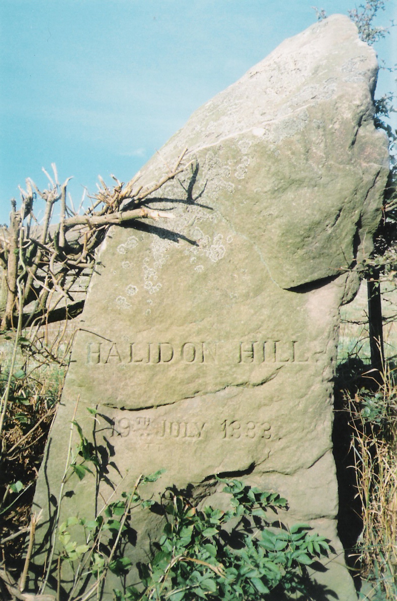
Halidon Hill

Halidon Hill is a summit, about 2 miles (3 km) west of the centre of Berwick-upon-Tweed, on the border of England and Scotland. It reaches 600 feet (180...

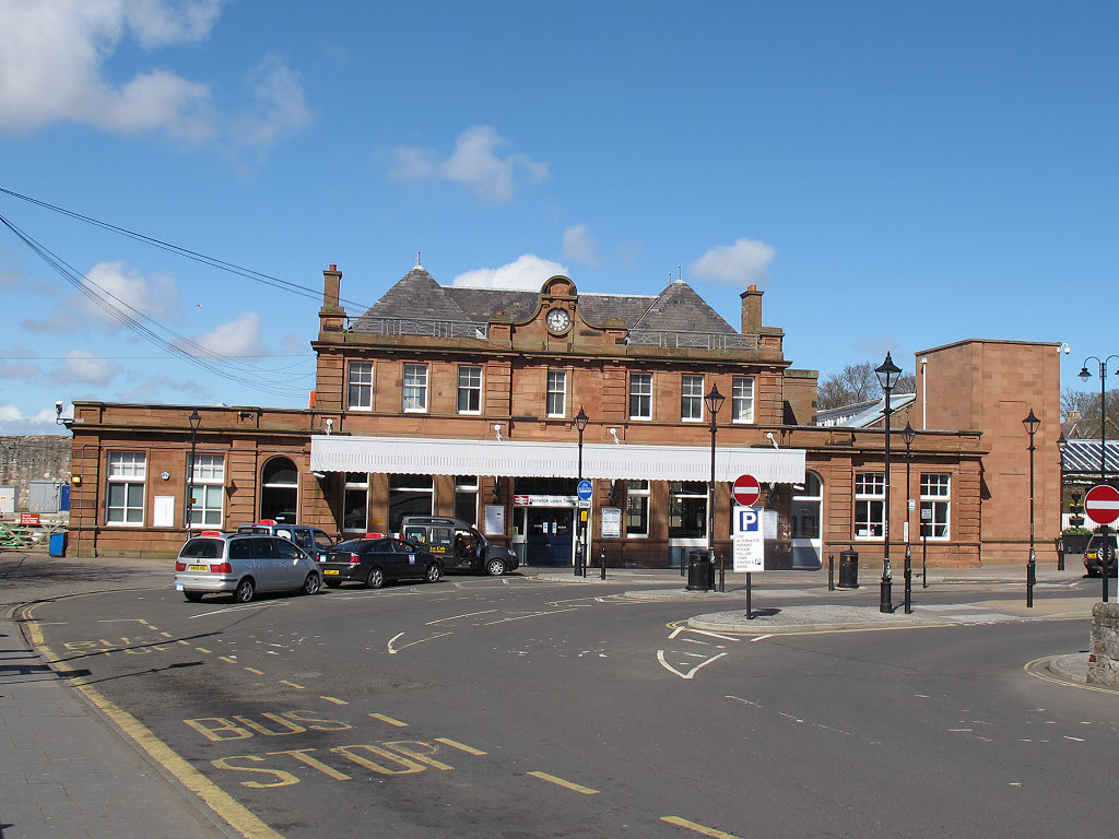
Berwick-upon-Tweed railway station

Berwick-upon-Tweed is a railway station on the East Coast Main Line, which runs between London King's Cross and Edinburgh Waverley. The station, situated...

Battle of Halidon Hill

The Battle of Halidon Hill took place on 19 July 1333 when a Scottish army under Sir Archibald Douglas attacked an English army commanded by King Edward...

Nearby Amenities

Located within 500m of 55.797445,-2.0160681
St John's Haven
Place: locality
Lat/Long: 55.7977832/-2.0171804
Needles Eye
Place: locality
Lat/Long: 55.7936816/-2.0121993
Barrier: stile
Lat/Long: 55.7935996/-2.0172699
Barrier: stile
Lat/Long: 55.7936716/-2.0170299
Railway: crossing
Lat/Long: 55.7936359/-2.0171488
Railway: crossing
Lat/Long: 55.7936169/-2.0172123
The data included in this document is from www.openstreetmap.org. The data is made available under ODbL.

Have you been to St John's Haven?

Leave your review of St John's Haven below (or comments, questions and feedback).