Bring Deeps

Sea, Estuary, Creek in Orkney

Scotland

Bring Deeps

Fish farms in Lyrawa Bay
Fish farms in Lyrawa Bay Credit: David Medcalf

Bring Deeps is a sea inlet located in the Orkney Islands, an archipelago situated off the northeastern coast of Scotland. This stunning natural feature is characterized by its vast expanse of water and its unique geological formation.

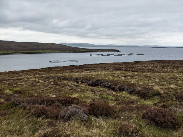
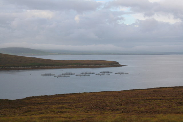
Bring Deeps is an estuary, which means that it is a partially enclosed coastal body of water where freshwater from rivers and streams mixes with saltwater from the sea. This mixing of waters creates a dynamic ecosystem, supporting a rich variety of marine life. The estuary provides a vital habitat for numerous species of fish, shellfish, and seabirds, making it a popular destination for nature enthusiasts and birdwatchers.

The creek is surrounded by picturesque landscapes, with rolling hills and rugged cliffs adorning its surroundings. Its pristine waters are often crystal clear, allowing visitors to witness the underwater world teeming with colorful fish and other marine creatures. The estuary also serves as a significant transportation route, allowing boats and ships to navigate through its waters to reach nearby settlements and islands.

Bring Deeps is not only a haven for wildlife but also a place of historical significance. The Orkney Islands have a rich cultural heritage, with ancient archaeological sites dating back thousands of years. The estuary itself is located near several notable landmarks, including ancient stone circles, burial mounds, and Viking settlements.

In conclusion, Bring Deeps is a breathtaking sea estuary located in the Orkney Islands. Its unique blend of saltwater and freshwater, coupled with its stunning natural beauty and historical significance, make it a must-visit destination for nature lovers and history enthusiasts alike.

If you have any feedback on the listing, please let us know in the comments section below.

Bring Deeps Images

Images are sourced within 2km of 58.872277/-3.1944691 or Grid Reference ND3198. Thanks to Geograph Open Source API. All images are credited.

Fish farms in Lyrawa Bay
Moorland above Pegal Bay
Lyrawa Bay From the road.
Lyrawa Bay
From the road.
B9047 above Lyrawa Bay
Old Milestone by the B9047, Hoy and Graemsay parish Milestone by the B9047, in parish of Hoy and Graemsay (Hoy District), East of Pegal Hill, on verge.

Inscription reads:-
N.NESS
5
{<-arrow}
HOY
6
{arrow->}

Grade C(S) listed.
Reference: LB48377 <span class="nowrap"><a title="http://portal.historicenvironment.scot/designation/LB48377" rel="nofollow ugc noopener" href="http://portal.historicenvironment.scot/designation/LB48377">Link</a><img style="margin-left:2px;" alt="External link" title="External link - shift click to open in new window" src="https://s1.geograph.org.uk/img/external.png" width="10" height="10"/></span>

Surveyed

Milestone Society National ID: OR_HYHYNN06
Old Milestone by the B9047, Hoy and Graemsay parish
Milestone by the B9047, in parish of Hoy and Graemsay (Hoy District), East of Pegal Hill, on verge. Inscription reads:- N.NESS 5 {<-arrow} HOY 6 {arrow->} Grade C(S) listed. Reference: LB48377 LinkExternal link Surveyed Milestone Society National ID: OR_HYHYNN06
Lyrawa Bay
Lyrawa Bay
Rysa Sound and the island of Rysa Little
The eastern shore of Rysa Little
The eastern corner of Rysa Little
Hoy: bridge over Lyrawa Burn Looking just off course along the B9047 as it descends to Lywara Bay; in the background we see it ascend Lyrawa Hill along with a line of telegraph poles.
Hoy: bridge over Lyrawa Burn
Looking just off course along the B9047 as it descends to Lywara Bay; in the background we see it ascend Lyrawa Hill along with a line of telegraph poles.
The road and the miles to Lyness A lone milestone is found on the B9047 on the eastern flank of the island of Hoy.
The road and the miles to Lyness
A lone milestone is found on the B9047 on the eastern flank of the island of Hoy.
Salmon farming in Lyrawa Bay The word&amp;#039; &amp;quot;salmon&amp;quot;,&amp;quot;rabbit&amp;quot;, or &amp;quot;minister&amp;quot; are a few of the taboo words that are never uttered on board a fishing boat by Scottish fishermen. Bad luck will surely follow those who disregard this taboo. The men who work and net salmon will refer to them as &amp;quot;Redfish&amp;quot;.
Salmon farming in Lyrawa Bay
The word' "salmon","rabbit", or "minister" are a few of the taboo words that are never uttered on board a fishing boat by Scottish fishermen. Bad luck will surely follow those who disregard this taboo. The men who work and net salmon will refer to them as "Redfish".
Salmon farming in Rysa Sound
Cava Light from the ferry The light actually stands on the Calf of Cava peninsula.
Cava Light from the ferry
The light actually stands on the Calf of Cava peninsula.
Passing the Calf of Cava on the way to Lyness The Calf of Cava is an uninhabited island in the Orkney archipelago.
Passing the Calf of Cava on the way to Lyness
The Calf of Cava is an uninhabited island in the Orkney archipelago.
Calf of Cava The lighthouse on the northern point of Cava, seen from the ferry from Lyness to Houton. Photographer location from in-camera GPS is HY 31800025.
Calf of Cava
The lighthouse on the northern point of Cava, seen from the ferry from Lyness to Houton. Photographer location from in-camera GPS is HY 31800025.
Lighthouse on the Calf of Cava The northern tip of Cava viewed from a ferry travelling to Lyness from Houton.
Lighthouse on the Calf of Cava
The northern tip of Cava viewed from a ferry travelling to Lyness from Houton.
Calf of Cava Lighthouse Automatic lighthouse built in 1898. &lt;span class=&quot;nowrap&quot;&gt;&lt;a title=&quot;https://canmore.org.uk/site/74473/cava-calf-of-cava-lighthouse&quot; rel=&quot;nofollow ugc noopener&quot; href=&quot;https://canmore.org.uk/site/74473/cava-calf-of-cava-lighthouse&quot;&gt;Link&lt;/a&gt;&lt;img style=&quot;margin-left:2px;&quot; alt=&quot;External link&quot; title=&quot;External link - shift click to open in new window&quot; src=&quot;https://s1.geograph.org.uk/img/external.png&quot; width=&quot;10&quot; height=&quot;10&quot;/&gt;&lt;/span&gt;
Calf of Cava Lighthouse
Automatic lighthouse built in 1898. LinkExternal link
Show me another place!

Bring Deeps is located at Grid Ref: ND3198 (Lat: 58.872277, Lng: -3.1944691)

Unitary Authority: Orkney Islands

Police Authority: Highlands and Islands

What 3 Words

///decimals.inform.cured. Near Lyness, Orkney Islands

Nearby Locations

Bring Deeps

Related Wikis

Rysa Little

Rysa Little, commonly referred to as Rysa, is an uninhabited island in the Orkney archipelago in Scotland. It is approximately 32 hectares (79 acres) in...

Cava, Orkney

Cava is an uninhabited island in the Orkney archipelago in Scotland. It is 107 hectares (0.41 sq mi) in extent and rises to 38 metres (125 ft) above sea...

Gutter Sound

Gutter Sound is a sound in Orkney, Scotland, part of Scapa Flow. It lies to the west of the main harbour between the internal islands of Cava and Fara...

SMS Dresden (1917)

SMS Dresden was the second and final ship of the Cöln class of light cruisers to be completed and commissioned in the Kaiserliche Marine (Imperial Navy...

Have you been to Bring Deeps?

Leave your review of Bring Deeps below (or comments, questions and feedback).