Rysa Sound

Sea, Estuary, Creek in Orkney

Scotland

Rysa Sound

Moors above the Lyrawa Burn
Moors above the Lyrawa Burn Credit: David Medcalf

Rysa Sound is an estuary located in the Orkney Islands, a group of islands situated off the northeastern coast of Scotland. It is formed by the convergence of the North Sea and the Atlantic Ocean, creating a picturesque waterway that stretches between the islands of Rousay and Egilsay.

Spanning approximately 3 kilometers in length, Rysa Sound is characterized by its calm waters, making it an ideal location for various water activities such as sailing, kayaking, and fishing. The estuary is also home to a diverse range of marine life, including seals, dolphins, and various species of fish, attracting nature enthusiasts and wildlife lovers alike.

The surrounding landscape of Rysa Sound is breathtaking, with rolling green hills and rugged cliffs serving as a stunning backdrop. The area is rich in history and folklore, with several archaeological sites and ancient ruins scattered along its shores. One notable landmark is the Broch of Gurness, an Iron Age settlement that offers a glimpse into Orkney's past.

Rysa Sound is a haven for birdwatchers, as it serves as a habitat for a variety of seabirds, including puffins, guillemots, and fulmars. The estuary is also an important breeding ground for many species, making it a significant site for ornithological research and conservation efforts.

Overall, Rysa Sound is a captivating natural wonder that offers visitors a unique blend of tranquility, natural beauty, and cultural heritage. Whether exploring its waters, admiring its wildlife, or immersing oneself in its rich history, Rysa Sound provides a memorable experience for all who visit.

If you have any feedback on the listing, please let us know in the comments section below.
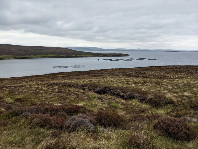
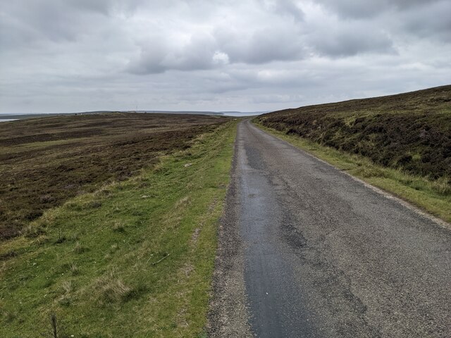
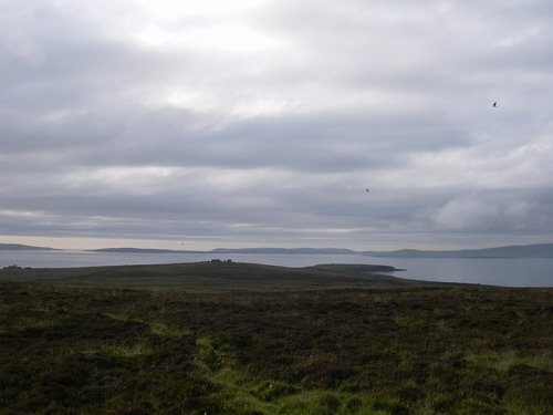
Rysa Sound Images

Images are sourced within 2km of 58.865725/-3.2103518 or Grid Reference ND3098. Thanks to Geograph Open Source API. All images are credited.

Moors above the Lyrawa Burn
The road heading down to Lyrawa Bay
The Pegal Burn heading for Pegal Bay
Fish farms in Lyrawa Bay
Moorland above Pegal Bay
Lyrawa Bay From the road.
Lyrawa Bay
From the road.
B9047 above Lyrawa Bay
Old Milestone by the B9047, Lyrawa Bay, Orkney Carved stone post on the B9047 road, Hoy & Graemsay, Orkney; West of Lyrawa Bay on verge, South-west side of road. 

Inscription reads:-
N.NESS
{arrow}
HOY
{arrow}

Milestone Society ID: OR_HYHYNN05.
Old Milestone by the B9047, Lyrawa Bay, Orkney
Carved stone post on the B9047 road, Hoy & Graemsay, Orkney; West of Lyrawa Bay on verge, South-west side of road. Inscription reads:- N.NESS {arrow} HOY {arrow} Milestone Society ID: OR_HYHYNN05.
Old Milestone by the B9047, Hoy and Graemsay parish Milestone by the B9047, in parish of Hoy and Graemsay (Hoy District), East of Pegal Hill, on verge.

Inscription reads:-
N.NESS
5
{<-arrow}
HOY
6
{arrow->}

Grade C(S) listed.
Reference: LB48377 <span class="nowrap"><a title="http://portal.historicenvironment.scot/designation/LB48377" rel="nofollow ugc noopener" href="http://portal.historicenvironment.scot/designation/LB48377">Link</a><img style="margin-left:2px;" alt="External link" title="External link - shift click to open in new window" src="https://s1.geograph.org.uk/img/external.png" width="10" height="10"/></span>

Surveyed

Milestone Society National ID: OR_HYHYNN06
Old Milestone by the B9047, Hoy and Graemsay parish
Milestone by the B9047, in parish of Hoy and Graemsay (Hoy District), East of Pegal Hill, on verge. Inscription reads:- N.NESS 5 {<-arrow} HOY 6 {arrow->} Grade C(S) listed. Reference: LB48377 LinkExternal link Surveyed Milestone Society National ID: OR_HYHYNN06
Lyrawa Bay
Lyrawa Bay
The road across the moorland
Rysa Sound and the island of Rysa Little
Muckle Rysa farm
Muckle Rysa farm
The eastern shore of Rysa Little
The eastern corner of Rysa Little
Lochan, Shell Hill, Hoy, Orkney Looking towards Fara with Flotta behind.  Lyness harbour can be seen on the right.
Lochan, Shell Hill, Hoy, Orkney
Looking towards Fara with Flotta behind. Lyness harbour can be seen on the right.
Hoy: bridge over Lyrawa Burn Looking just off course along the B9047 as it descends to Lywara Bay; in the background we see it ascend Lyrawa Hill along with a line of telegraph poles.
Hoy: bridge over Lyrawa Burn
Looking just off course along the B9047 as it descends to Lywara Bay; in the background we see it ascend Lyrawa Hill along with a line of telegraph poles.
Hoy: the B9047 heads down to Lyrawa Bay Looking down towards Lyrawa Bay from the northwest, with the end of the island of Rysa Little on the far left.
Hoy: the B9047 heads down to Lyrawa Bay
Looking down towards Lyrawa Bay from the northwest, with the end of the island of Rysa Little on the far left.
Show me another place!

Rysa Sound is located at Grid Ref: ND3098 (Lat: 58.865725, Lng: -3.2103518)

Unitary Authority: Orkney Islands

Police Authority: Highlands and Islands

What 3 Words

///fruit.opposites.slack. Near Lyness, Orkney Islands

Nearby Locations

Rysa Sound

Related Wikis

Rysa Little

Rysa Little, commonly referred to as Rysa, is an uninhabited island in the Orkney archipelago in Scotland. It is approximately 32 hectares (79 acres) in...

Gutter Sound

Gutter Sound is a sound in Orkney, Scotland, part of Scapa Flow. It lies to the west of the main harbour between the internal islands of Cava and Fara...

Cava, Orkney

Cava is an uninhabited island in the Orkney archipelago in Scotland. It is 107 hectares (0.41 sq mi) in extent and rises to 38 metres (125 ft) above sea...

Fara, Orkney

Fara (, Old Norse: Færey ) is a small island in Orkney, Scotland, lying in Scapa Flow between the islands of Flotta and Hoy. It has been uninhabited since...

Nearby Amenities

Located within 500m of 58.865725,-3.2103518
Pegal Head
Place: locality
Lat/Long: 58.8642064/-3.2114607
The data included in this document is from www.openstreetmap.org. The data is made available under ODbL.

Have you been to Rysa Sound?

Leave your review of Rysa Sound below (or comments, questions and feedback).