St Osyth Beach

Beach in Essex Tendring

England

St Osyth Beach

Lee-over-Sands If it is peace and quiet you are after these chalets are about as isolated as you can get within a sixty mile radius of central London. It must be a constant battle with the elements to keep them maintained.
Lee-over-Sands Credit: Glyn Baker

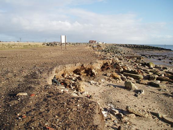
St Osyth Beach is a popular seaside destination located in Essex, England. The beach stretches for approximately one mile along the coastline, offering visitors plenty of space to relax and enjoy the stunning views of the North Sea. The sandy beach is backed by grassy dunes and is a designated Site of Special Scientific Interest due to its unique flora and fauna.

The beach is ideal for families, with shallow waters and gentle waves making it a safe spot for swimming and paddling. There are also opportunities for water sports such as windsurfing and kite surfing. St Osyth Beach is known for its clean and well-maintained facilities, including toilets, showers, and a beach cafe serving refreshments and snacks.

Visitors can take leisurely walks along the promenade or explore the nearby nature reserve for birdwatching and wildlife spotting. The beach is easily accessible by car, with ample parking available nearby. St Osyth Beach is a peaceful and picturesque destination, perfect for a day out by the sea.

If you have any feedback on the listing, please let us know in the comments section below.

St Osyth Beach Images

Images are sourced within 2km of 51.770693/1.0752099 or Grid Reference TM1212. Thanks to Geograph Open Source API. All images are credited.

Lee-over-Sands If it is peace and quiet you are after these chalets are about as isolated as you can get within a sixty mile radius of central London. It must be a constant battle with the elements to keep them maintained.
Lee-over-Sands
If it is peace and quiet you are after these chalets are about as isolated as you can get within a sixty mile radius of central London. It must be a constant battle with the elements to keep them maintained.
Sewage Farm This is the sewage farm at Lee-over-Sands
Sewage Farm
This is the sewage farm at Lee-over-Sands
Martello Tower at Jaywick, Essex This view is taken from East Beach caravan site. The tower has recently been renovated and is now open to the public.
Martello Tower at Jaywick, Essex
This view is taken from East Beach caravan site. The tower has recently been renovated and is now open to the public.
Remains of track outside the sea-wall A (tidal) track used to lead out from the sea-wall to the edge of the sea. Now too badly eroded.
Remains of track outside the sea-wall
A (tidal) track used to lead out from the sea-wall to the edge of the sea. Now too badly eroded.
Entrance to a caravan park
Part of Seawick Holiday Village
Footpath to Seawick This is the footpath along the sea wall from Lee-Over-Sands to Seawick. St Osyth Marsh is to the left and the saltmarshes are to the right.
Footpath to Seawick
This is the footpath along the sea wall from Lee-Over-Sands to Seawick. St Osyth Marsh is to the left and the saltmarshes are to the right.
St Osyth Marsh Footbridge over a dike in St Osyth Marsh
St Osyth Marsh
Footbridge over a dike in St Osyth Marsh
St Osyth Saltmarsh This picture was taken from the seawall footpath from Lee-over-Sands to Seawick
St Osyth Saltmarsh
This picture was taken from the seawall footpath from Lee-over-Sands to Seawick
Ruin in the Marsh This ruined concrete farm building is in St Osyth Marsh
Ruin in the Marsh
This ruined concrete farm building is in St Osyth Marsh
Pillbox and Anti Tank Traps This World War Two Pillbox and Anti Tank Traps on the Marshes at Lee-Over-Sands.
The buildings in the background are at Wigboro Wick Farm.
Pillbox and Anti Tank Traps
This World War Two Pillbox and Anti Tank Traps on the Marshes at Lee-Over-Sands. The buildings in the background are at Wigboro Wick Farm.
Beach Road ? (Creek) This is where Beach Road goes over the Sea Wall onto Essex Wildlife Trust's
Nature Reserve at Colne Point.
Beach Road ? (Creek)
This is where Beach Road goes over the Sea Wall onto Essex Wildlife Trust's Nature Reserve at Colne Point.
Sea Holly Eryngium maritimum.

See <span class="nowrap"><a title="http://www.botanicalkeys.co.uk/flora/content/species.asp?1219" rel="nofollow ugc noopener" href="http://www.botanicalkeys.co.uk/flora/content/species.asp?1219">Link</a><img style="margin-left:2px;" alt="External link" title="External link - shift click to open in new window" src="https://s1.geograph.org.uk/img/external.png" width="10" height="10"/></span>
Sea Holly
Eryngium maritimum. See LinkExternal link
Wall Street The Wall this refers to is the Sea Wall, which is the green line that you can see running across the centre of the photo.
Wall Street
The Wall this refers to is the Sea Wall, which is the green line that you can see running across the centre of the photo.
St Osyth Beach Taken from the Martello Tower at Jaywick.
St Osyth Beach
Taken from the Martello Tower at Jaywick.
Saltmarsh and Ray Creek The water in this Saltmarsh is Ray Creek. This was a particularly high tide, so the sides of the bank are not visible. The creek ends just out of shot to the left.
Saltmarsh and Ray Creek
The water in this Saltmarsh is Ray Creek. This was a particularly high tide, so the sides of the bank are not visible. The creek ends just out of shot to the left.
Beach Road This unmade road is the access road to Colne Point Nature Reserve.
Beach Road
This unmade road is the access road to Colne Point Nature Reserve.
Low tide in Ray Creek A Little Egret and Gull in Ray Creek at low tide.
Low tide in Ray Creek
A Little Egret and Gull in Ray Creek at low tide.
Show me another place!

St Osyth Beach is located at Grid Ref: TM1212 (Lat: 51.770693, Lng: 1.0752099)

Administrative County: Essex

District: Tendring

Police Authority: Essex

What 3 Words

///overdone.recover.yarn. Near St Osyth, Essex

Nearby Locations

St Osyth Beach

Related Wikis

Jaywick Martello Tower

Jaywick Martello Tower is a renovated Martello tower at Jaywick, 2.7 miles (4.3 km) south-west of Clacton-on-Sea, Essex. It now functions as an arts, heritage...

Colne Point

Colne Point is a 276.4-hectare (683-acre) nature reserve south-west of St Osyth in Essex. It is managed by the Essex Wildlife Trust. It is part of the...

Lee-over-Sands

Lee-over-Sands is a small coastal hamlet in the civil parish of St Osyth, in the Tendring district of Essex, England. It is located close to the mouth...

Crossways railway station

Crossways railway station was the upper terminus of the short-lived Jaywick Miniature Railway in Essex, England.Crossways had a single platform made of...

Nearby Amenities

Located within 500m of 51.770693,1.0752099
Power: pole
Source: bing
Lat/Long: 51.7732783/1.0720674
Power: pole
Source: bing
Lat/Long: 51.7732857/1.0755259
The data included in this document is from www.openstreetmap.org. The data is made available under ODbL.

Have you been to St Osyth Beach?

Leave your review of St Osyth Beach below (or comments, questions and feedback).