Romney Sands

Beach in Kent Shepway

England

Romney Sands

St. Peter's Church, Greatstone, Kent
St. Peter's Church, Greatstone, Kent Credit: Paul Russon

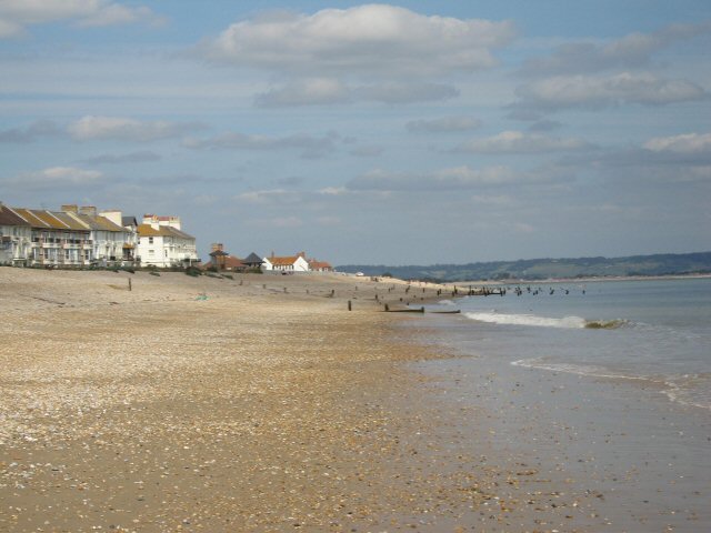
Romney Sands is a picturesque beach located in the county of Kent, England. Situated on the south coast of the Romney Marsh, it offers a serene and tranquil environment for visitors to unwind and enjoy the beauty of nature. With its stunning sandy shores and breathtaking views of the English Channel, Romney Sands is a popular destination for both locals and tourists alike.

The beach is renowned for its long stretch of golden sand, which provides ample space for sunbathing, picnicking, and leisurely walks along the shore. Its gently sloping seabed makes it an ideal spot for swimming, paddling, and other water activities, especially during the summer months when the water is relatively warm.

Romney Sands also boasts a range of amenities to enhance visitors' experience. These include well-maintained public toilets, ample parking facilities, and a nearby holiday park that offers accommodation options for those wanting to extend their stay. The beach is easily accessible, with good road connections and public transport links available.

Aside from its natural beauty, Romney Sands is also known for its rich history. It is located near the historic town of New Romney, which was once a bustling port during the medieval period. Visitors can explore the town's ancient churches, museums, and other historic landmarks, offering a glimpse into the area's fascinating past.

Overall, Romney Sands is a charming and idyllic beach that offers a perfect blend of natural beauty, recreational activities, and historical significance. Whether you are seeking a peaceful retreat or an adventure-filled day by the sea, this Kent beach has something to offer for everyone.

If you have any feedback on the listing, please let us know in the comments section below.
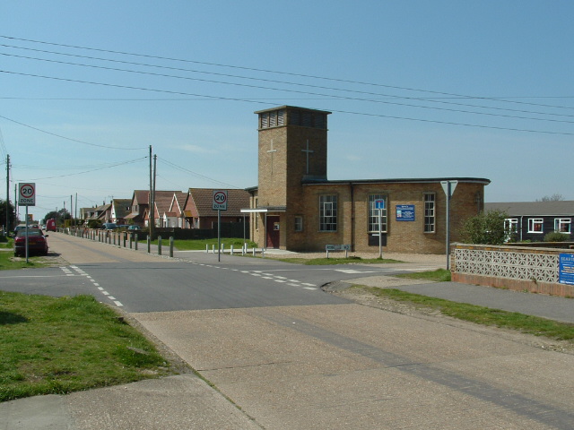
Romney Sands Images

Images are sourced within 2km of 50.97434/0.96985899 or Grid Reference TR0823. Thanks to Geograph Open Source API. All images are credited.

St. Peter's Church, Greatstone, Kent
New Romney Station, New Romney, Kent. This is the main station, locomotive shed and headquarters of the Romney, Hythe & Dymchurch Railway. The station opened in 1927 and is still in use by holidaymakers.
New Romney Station, New Romney, Kent.
This is the main station, locomotive shed and headquarters of the Romney, Hythe & Dymchurch Railway. The station opened in 1927 and is still in use by holidaymakers.
Romney Sands This view looks south down Romney Sands with Dungeness power Station in the far distance.
Romney Sands
This view looks south down Romney Sands with Dungeness power Station in the far distance.
New Romney. Headquarters of the R.H.& D.R.
New Romney.
Headquarters of the R.H.& D.R.
New Romney. Some might call it "sacrilege" but the R.H.& D.R. do run diesel traction.
New Romney.
Some might call it "sacrilege" but the R.H.& D.R. do run diesel traction.
New Romney Turntable, Romney, Hythe & Dymchurch Railway
New Romney
Turntable, Romney, Hythe & Dymchurch Railway
New Romney Shunting on the Romney, Hythe & Dymchurch Railway
New Romney
Shunting on the Romney, Hythe & Dymchurch Railway
New Romney Perfection in miniature, Romney, Hythe & Dymchurch Railway
New Romney
Perfection in miniature, Romney, Hythe & Dymchurch Railway
New Romney Tunnel under Beach Road, Romney, Hythe & Dymchurch Railway
New Romney
Tunnel under Beach Road, Romney, Hythe & Dymchurch Railway
New Romney The "Captain Howey" Hotel, named after the Founder of the Romney, Hythe & Dymchurch Railway
New Romney
The "Captain Howey" Hotel, named after the Founder of the Romney, Hythe & Dymchurch Railway
New Romney Headquarters of the Romney, Hythe & Dymchurch Railway
New Romney
Headquarters of the Romney, Hythe & Dymchurch Railway
Beachfront properties behind dunes, Greatstone-on-Sea With Littlestone-on-Sea to the right.
Beachfront properties behind dunes, Greatstone-on-Sea
With Littlestone-on-Sea to the right.
Sea Kale, Romney Sands
Toadflax, Romney Sands
Signal box at New Romney Station On the Romney, Hythe & Dymchurch light railway.
Signal box at New Romney Station
On the Romney, Hythe & Dymchurch light railway.
The train to Dungeness at the New Romney Station cold weather helps emphasise the stream.
The train to Dungeness at the New Romney Station
cold weather helps emphasise the stream.
Taking on water at the New Romney Station you can almost smell the mixture of smoke and steam.
Taking on water at the New Romney Station
you can almost smell the mixture of smoke and steam.
The train to Hythe leaving New Romney Station.
Show me another place!

Romney Sands is located at Grid Ref: TR0823 (Lat: 50.97434, Lng: 0.96985899)

Administrative County: Kent

District: Shepway

Police Authority: Kent

What 3 Words

///lends.dumpy.sliders. Near New Romney, Kent

Nearby Locations

Romney Sands

Related Wikis

Greatstone-on-Sea

Greatstone is a village on the coast of Romney Marsh in Kent, England. It is east of the town of New Romney and split between the civil parishes of New...

Littlestone-on-Sea

Littlestone-on-Sea is a small coastal village in the parish of New Romney in Kent, England. It was established in the 1880s by Sir Robert Perks as a resort...

Greatstone Dunes railway station

Greatstone Dunes railway station was a station on the Romney, Hythe and Dymchurch Railway in Kent, England. Opened on 24 May 1928, this station was located...

Greatstone-on-Sea Halt railway station

Greatstone-on-Sea Halt was a railway station which served the modern village of Greatstone-on-Sea in Kent, England. The station opened in 1937 and closed...

Nearby Amenities

Located within 500m of 50.97434,0.96985899
Source: PGS
Lat/Long: 50.9731809/0.9658538
Source: PGS
Lat/Long: 50.9753121/0.9665995
Source: PGS
Lat/Long: 50.9777967/0.9674792
Bus Stop
Hardy Road
Bus: yes
Local Ref: adj
Naptan AtcoCode: 2400A024010A
Naptan Bearing: N
Naptan BusStopType: MKD
Naptan CommonName: Hardy Road
Naptan Indicator: adj
Naptan Landmark: Hardy Road
Naptan NaptanCode: kntdagja
Naptan RevisionNumber: 2
Naptan Status: act
Naptan Street: Coast Drive
Public Transport: platform
Ref: kntdagja
Shelter: yes
Source: naptan_import
Source Date: 2018-05-25
Lat/Long: 50.9724582/0.9637609
Bus Stop
Hardy Road
Bus: yes
Local Ref: opp
Naptan AtcoCode: 240099416
Naptan Bearing: S
Naptan BusStopType: MKD
Naptan CommonName: Hardy Road
Naptan Indicator: opp
Naptan Landmark: Hardy Road
Naptan NaptanCode: kntgpjdw
Naptan RevisionNumber: 2
Naptan Status: act
Naptan Street: Coast Drive
Public Transport: platform
Ref: kntgpjdw
Source: naptan_import
Source Date: 2018-05-25
Lat/Long: 50.9724424/0.9638827
Bus Stop
Clark Road
Bus: yes
Naptan AtcoCode: 2400A024020A
Naptan Bearing: N
Naptan CommonName: Clarke Road
Naptan Indicator: adj
Naptan Landmark: Lifeboat Station
Naptan NaptanCode: kntdagjd
Naptan Street: Coast Drive
Naptan Verified: no
Public Transport: platform
Source: naptan_import
Lat/Long: 50.9772462/0.9658387
Bus Stop
Clark Road
Bus: yes
Naptan AtcoCode: 2400A024030A
Naptan Bearing: S
Naptan CommonName: Clarke Road
Naptan Indicator: opp
Naptan Landmark: Lifeboat Station
Naptan NaptanCode: kntdagjg
Naptan Street: Coast Drive
Naptan Verified: no
Public Transport: platform
Source: naptan_import
Lat/Long: 50.9772951/0.9659863
Leisure: slipway
Seamark Small Craft Facility Category: slipway
Seamark Type: small_craft_facility
Lat/Long: 50.9744245/0.9666192
NDNRO Cabinet 3
Colour: green
Man Made: street_cabinet
Operator: Openreach
Operator Wikidata: Q7096543
Utility: telecom
Lat/Long: 50.9726681/0.9639725
Generator Method: photovoltaic
Generator Output Electricity: yes
Generator Source: solar
Generator Type: solar_photovoltaic_panel
Location: roof
Power: generator
Lat/Long: 50.9745922/0.9627467
Generator Method: photovoltaic
Generator Output Electricity: yes
Generator Source: solar
Generator Type: solar_photovoltaic_panel
Location: roof
Power: generator
Lat/Long: 50.9754046/0.9632362
Generator Method: photovoltaic
Generator Output Electricity: yes
Generator Source: solar
Generator Type: solar_photovoltaic_panel
Location: roof
Power: generator
Lat/Long: 50.9758234/0.9635085
Post Box
Fixme: Post Box may have been moved from former Post Office at 10 The Parade. Survey needed to confirm reference (suspected TN28 229)
Lat/Long: 50.9767707/0.9655755
Generator Method: photovoltaic
Generator Output Electricity: yes
Generator Source: solar
Generator Type: solar_photovoltaic_panel
Location: roof
Power: generator
Lat/Long: 50.9726821/0.964167
Generator Method: photovoltaic
Generator Output Electricity: yes
Generator Source: solar
Generator Type: solar_photovoltaic_panel
Location: roof
Power: generator
Lat/Long: 50.97275/0.9642307
Generator Method: photovoltaic
Generator Output Electricity: yes
Generator Source: solar
Generator Type: solar_photovoltaic_panel
Location: roof
Power: generator
Lat/Long: 50.9723544/0.964053
Generator Method: photovoltaic
Generator Output Electricity: yes
Generator Source: solar
Generator Type: solar_photovoltaic_panel
Location: roof
Power: generator
Lat/Long: 50.9763326/0.9658313
Generator Method: photovoltaic
Generator Output Electricity: yes
Generator Source: solar
Generator Type: solar_photovoltaic_panel
Location: roof
Power: generator
Lat/Long: 50.9758906/0.9655617
Generator Method: photovoltaic
Generator Output Electricity: yes
Generator Source: solar
Generator Type: solar_photovoltaic_panel
Location: roof
Power: generator
Lat/Long: 50.9729793/0.9634937
Crossing
Crossing: uncontrolled
Tactile Paving: yes
Lat/Long: 50.972632/0.96379
Crossing
Crossing: uncontrolled
Lat/Long: 50.9780352/0.9662742
Designated
Barrier: chain
Emergency: designated
Lat/Long: 50.9745103/0.9661156
Leisure: slipway
Seamark Small Craft Facility Category: slipway
Seamark Type: small_craft_facility
Lat/Long: 50.974268/0.9665716
Post Box
Operator: Royal Mail
Operator Wikidata: Q638098
Post Box Type: wall
Ref: TN28 92D
Royal Cypher: GVIR
Royal Cypher Wikidata: Q33102169
Lat/Long: 50.9724228/0.9637599
The data included in this document is from www.openstreetmap.org. The data is made available under ODbL.

Have you been to Romney Sands?

Leave your review of Romney Sands below (or comments, questions and feedback).