Aldbrough Sands

Beach in Yorkshire

England

Aldbrough Sands

The end of the road An abrupt end to Seaside Road at Mount Pleasant as coastal erosion takes its toll
The end of the road Credit: Richard Croft

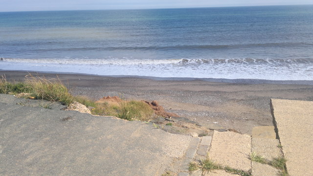
Aldbrough Sands is a picturesque beach located in the East Riding of Yorkshire, England. Situated along the North Sea coast, this sandy expanse stretches for approximately 3 miles and offers visitors a serene and tranquil setting to enjoy the natural beauty of the area.

The beach at Aldbrough Sands is known for its soft golden sand, which provides a perfect spot for sunbathing, picnicking, and building sandcastles. The beach is backed by rolling dunes, adorned with tufts of grass and wildflowers, creating a stunning backdrop against the azure waters of the sea.

Aldbrough Sands is a popular destination for families and nature enthusiasts alike. The beach boasts a Blue Flag status, indicating its cleanliness and excellent water quality. Visitors can take a refreshing dip in the sea or explore the rock pools that emerge at low tide, revealing an array of interesting marine life.

The beach is also a haven for birdwatchers, as it lies in close proximity to the Spurn Point Nature Reserve. Here, visitors can catch a glimpse of various bird species, including the iconic puffins and oystercatchers.

Facilities at Aldbrough Sands include ample parking spaces, public toilets, and a café serving refreshments and snacks. Lifeguards are on duty during the summer months, ensuring the safety of those venturing into the water.

Overall, Aldbrough Sands offers a peaceful and idyllic coastal experience, with its unspoiled beauty and range of activities making it a must-visit destination for beach lovers and nature enthusiasts in Yorkshire.

If you have any feedback on the listing, please let us know in the comments section below.

Aldbrough Sands Images

Images are sourced within 2km of 53.827469/-0.07909019 or Grid Reference TA2638. Thanks to Geograph Open Source API. All images are credited.

The end of the road An abrupt end to Seaside Road at Mount Pleasant as coastal erosion takes its toll
The end of the road
An abrupt end to Seaside Road at Mount Pleasant as coastal erosion takes its toll
Land's end A precipitous drop over the North Cliff lies beyond the end of Seaside Road <a title="https://www.geograph.org.uk/photo/2309841" href="https://www.geograph.org.uk/photo/2309841">Link</a> as coastal erosion carves away at the Holderness coast
Land's end
A precipitous drop over the North Cliff lies beyond the end of Seaside Road Link as coastal erosion carves away at the Holderness coast
Road closed The access road to the caravan park has slipped further towards the North Sea  since November 2010 <a title="https://www.geograph.org.uk/photo/2152497" href="https://www.geograph.org.uk/photo/2152497">Link</a>
Road closed
The access road to the caravan park has slipped further towards the North Sea since November 2010 Link
Who Would Want To? This is the end of the road from Aldbrough village to the North Sea coastline.  The road gets shorter by about 4m every year and part of it, as seen in this picture, is half way down the cliff..... complete with its double yellow lines!  Would you want to park on this section?...... I certainly wouldn't!!
Who Would Want To?
This is the end of the road from Aldbrough village to the North Sea coastline. The road gets shorter by about 4m every year and part of it, as seen in this picture, is half way down the cliff..... complete with its double yellow lines! Would you want to park on this section?...... I certainly wouldn't!!
Road's end near Aldbrough
Notices at Seaside Road End, Aldbrough This photo shows the North Sea from the end of Seaside Road. The Red notices both say: "Danger. Cliffs subject to coastal erosion. Do not proceed". The other notice on the right of the photo says: "Danger. Unexploded ordnance on this beach. It may explode and kill you. Do not approach or touch any Military or unidentified objects". Ministry of Defence.
Notices at Seaside Road End, Aldbrough
This photo shows the North Sea from the end of Seaside Road. The Red notices both say: "Danger. Cliffs subject to coastal erosion. Do not proceed". The other notice on the right of the photo says: "Danger. Unexploded ordnance on this beach. It may explode and kill you. Do not approach or touch any Military or unidentified objects". Ministry of Defence.
Coastal Erosion at Seaside Road end, Aldbrough This photo shows the erosion that has taken place with part of the road having collapsed. The beach and sea can be seen beyond it.
Coastal Erosion at Seaside Road end, Aldbrough
This photo shows the erosion that has taken place with part of the road having collapsed. The beach and sea can be seen beyond it.
The end of the road at Seaside Road, Aldbrough This photo shows Seaside Road having collapsed with double yellow lines still visible. The beach and North Sea can be seen beyond it.
The end of the road at Seaside Road, Aldbrough
This photo shows Seaside Road having collapsed with double yellow lines still visible. The beach and North Sea can be seen beyond it.
Seaside Road, Aldbrough The road is perpendicular to the sea, but each house will have its turn to be by the sea.
Seaside Road, Aldbrough
The road is perpendicular to the sea, but each house will have its turn to be by the sea.
Wind Vane on Seaside Road, Aldbrough
Houses on Seaside Road, Aldbrough
A bend in Seaside Road, Aldbrough
Drain off Seaside Road, Aldbrough
Crop field off Seaside Road, Aldbrough
Crop field north of Seaside Road
Drain beside Seaside Road Looking east.
Drain beside Seaside Road
Looking east.
Bungalows on Seaside Road
Crop field north of Seaside Road
Show me another place!

Aldbrough Sands is located at Grid Ref: TA2638 (Lat: 53.827469, Lng: -0.07909019)

Division: East Riding

Unitary Authority: East Riding of Yorkshire

Police Authority: Humberside

What 3 Words

///milk.radiated.rent. Near Aldbrough, East Yorkshire

Related Wikis

East Newton

East Newton is a hamlet in the civil parish of Aldbrough, in the East Riding of Yorkshire, England, in an area known as Holderness. It is situated approximately...

Colden Parva

Colden Parva (also known as Little Cowden) is a former village and ecclesiastical parish of the East Riding of Yorkshire that was lost due to coastal erosion...

Aldbrough, East Riding of Yorkshire

Aldbrough is a village and civil parish in the East Riding of Yorkshire, England, about 12 miles (19 km) north-east of Hull at the junction of the B1242...

Garton

Garton (or Garton in Holderness) is a village in the East Riding of Yorkshire, England, in an area known as Holderness. It is situated approximately 7...

Nearby Amenities

Located within 500m of 53.827469,-0.07909019
Source: PGS
Lat/Long: 53.8252415/-0.0776077
Source: PGS
Lat/Long: 53.826549/-0.0790148
The data included in this document is from www.openstreetmap.org. The data is made available under ODbL.

Have you been to Aldbrough Sands?

Leave your review of Aldbrough Sands below (or comments, questions and feedback).