Ayre of Sandwick

Beach in Shetland

Scotland

Ayre of Sandwick

Trondra: Stream Sound from Southerhouse Looking along Stream Sound, separating the islands of Trondra (left) and East Burra; the timy island between them is apparently unnamed. In the background, the West Voe of Quarff cuts into the big hills of the Shetland mainland.
Trondra: Stream Sound from Southerhouse Credit: Chris Downer

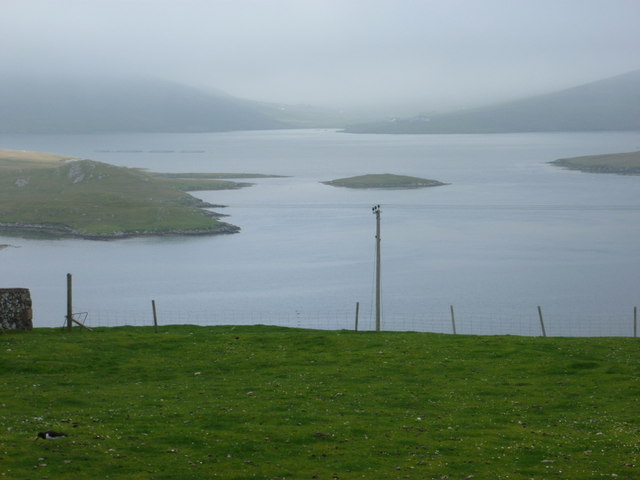
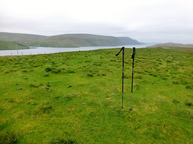
Ayre of Sandwick is a picturesque beach located in the Shetland Islands, Scotland. Situated on the east coast of Mainland Shetland, it is renowned for its stunning natural beauty and tranquil atmosphere. The beach stretches for approximately one mile and is framed by rugged cliffs, offering visitors breathtaking views of the North Sea.

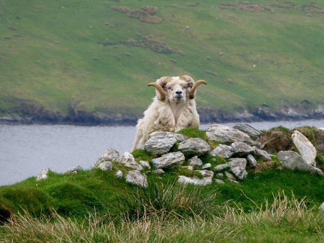
The sandy shoreline of Ayre of Sandwick is a haven for nature lovers and outdoor enthusiasts. The beach is home to a rich variety of wildlife, including seabirds, seals, and occasionally otters. Birdwatchers can spot species such as puffins, guillemots, and fulmars nesting in the cliffs adjacent to the beach.

The crystal-clear waters of Ayre of Sandwick are ideal for swimming, although the temperature can be quite chilly even during the summer months. The beach is also a popular spot for kayaking and canoeing, allowing visitors to explore the coastline and nearby caves.

Ayre of Sandwick offers a peaceful and secluded setting, making it a perfect destination for a relaxing day out. The beach is easily accessible by car, with a small parking area available nearby. Visitors can enjoy picnicking on the soft sand, taking long walks along the coast, or simply admiring the stunning views.

Overall, Ayre of Sandwick is a hidden gem in the Shetland Islands, offering a beautiful beach experience and a chance to connect with nature in a tranquil setting.

If you have any feedback on the listing, please let us know in the comments section below.

Ayre of Sandwick Images

Images are sourced within 2km of 60.107648/-1.2997006 or Grid Reference HU3936. Thanks to Geograph Open Source API. All images are credited.

Trondra: Stream Sound from Southerhouse Looking along Stream Sound, separating the islands of Trondra (left) and East Burra; the timy island between them is apparently unnamed. In the background, the West Voe of Quarff cuts into the big hills of the Shetland mainland.
Trondra: Stream Sound from Southerhouse
Looking along Stream Sound, separating the islands of Trondra (left) and East Burra; the timy island between them is apparently unnamed. In the background, the West Voe of Quarff cuts into the big hills of the Shetland mainland.
West Burra: postbox № ZE2 8, Southerhouse A small postbox serving the Southerhouse hamlet, emptied on weekdays and Saturdays at 7:30am. The backdrop is the Clift Hills, on the western edge of the Shetland mainland, rising into the mist.
West Burra: postbox № ZE2 8, Southerhouse
A small postbox serving the Southerhouse hamlet, emptied on weekdays and Saturdays at 7:30am. The backdrop is the Clift Hills, on the western edge of the Shetland mainland, rising into the mist.
Hamnavoe: Sands of Meal Looking across this short sandy beach in a bay to the south of Hamnavoe.
Hamnavoe: Sands of Meal
Looking across this short sandy beach in a bay to the south of Hamnavoe.
Hamnavoe: Meal Kirk A small, simple parish church in the eastern part of Hamnavoe.
Hamnavoe: Meal Kirk
A small, simple parish church in the eastern part of Hamnavoe.
Trondra: pirate scarecrow An unusual scarecrow in a field alongside the B9074.
Trondra: pirate scarecrow
An unusual scarecrow in a field alongside the B9074.
Lang Sound
Lang Sound
Meal Kirk, Hamnavoe Built in 1907 as a mission church of the Church of Scotland. Small grey-harled church with white painted window surrounds and quoins. Simple bellcote on east gable. Improvements are planned to increase use of the building by the community.
Meal Kirk, Hamnavoe
Built in 1907 as a mission church of the Church of Scotland. Small grey-harled church with white painted window surrounds and quoins. Simple bellcote on east gable. Improvements are planned to increase use of the building by the community.
Bruna Ness Bagged with Tricky Speirs with view towards the bridge that connect Trondra to West Burra.
Name: Bruna Ness
Hill number: 104041
Height: 59m / 194ft
Area:22: Shetland Islands
Class:0
Grid ref: HU382368 (est)
Drop: 43m
Col: 16m
Bruna Ness
Bagged with Tricky Speirs with view towards the bridge that connect Trondra to West Burra. Name: Bruna Ness Hill number: 104041 Height: 59m / 194ft Area:22: Shetland Islands Class:0 Grid ref: HU382368 (est) Drop: 43m Col: 16m
Old Boat Near Setter Old boat near hamlet of Setter with view across to Hamnavoe.
Old Boat Near Setter
Old boat near hamlet of Setter with view across to Hamnavoe.
Trondra, Island High Point Bagged with Tricky Speirs.
Name:Trondra
Hill number: 104032
Height: 61m / 200ft
Area:22: Shetland Islands
Class: 0
Grid ref: HU395363 (est)
Drop: 61m
Col: Sea
Trondra, Island High Point
Bagged with Tricky Speirs. Name:Trondra Hill number: 104032 Height: 61m / 200ft Area:22: Shetland Islands Class: 0 Grid ref: HU395363 (est) Drop: 61m Col: Sea
Shetland Ram This was as close as I got to this nervous Shetland ram grazing in the field that contain the island high point of Tronda.
Shetland Ram
This was as close as I got to this nervous Shetland ram grazing in the field that contain the island high point of Tronda.
Brough Hill Bagged with Tricky Speirs.
Name: Brough Hill
Hill number: 104033
Height: 61m / 200ft
Area:22: Shetland Islands
Class: 0
Grid ref: HU377351 (est)
Drop: 49m
Col: 12m
Brough Hill
Bagged with Tricky Speirs. Name: Brough Hill Hill number: 104033 Height: 61m / 200ft Area:22: Shetland Islands Class: 0 Grid ref: HU377351 (est) Drop: 49m Col: 12m
Hamnavoe: lifebuoy at Meal Beach This lifebuoy is both functional and artistic, and is hooked to the kissing gate at the top of the path leading down to the beach.
Hamnavoe: lifebuoy at Meal Beach
This lifebuoy is both functional and artistic, and is hooked to the kissing gate at the top of the path leading down to the beach.
Hamnavoe: across Meal Beach Looking across the <a href="https://www.geograph.org.uk/photo/2701583">HU3735 : Hamnavoe: Sands of Meal</a> from rocks at the back of the beach.
Hamnavoe: across Meal Beach
Looking across the HU3735 : Hamnavoe: Sands of Meal from rocks at the back of the beach.
Hamnavoe: sandcastle on Meal Beach Clearly the <a href="https://www.geograph.org.uk/photo/2701583">HU3735 : Hamnavoe: Sands of Meal</a> have provided some youthful enjoyment today.
Hamnavoe: sandcastle on Meal Beach
Clearly the HU3735 : Hamnavoe: Sands of Meal have provided some youthful enjoyment today.
Hamnavoe: burnt schoolwork on Meal Beach Not the kind of debris one expects to find on a beach; investigation nearby revealed that it was the furthest straggler of a barbecue a few yards away.
Hamnavoe: burnt schoolwork on Meal Beach
Not the kind of debris one expects to find on a beach; investigation nearby revealed that it was the furthest straggler of a barbecue a few yards away.
Hamnavoe: an evening view Looking across the eastern side of Hamnavoe - bottom-right is the car park for Meal Beach - with the islands of Papa and Hildasay in the background. The land in the distance is the westside of the Shetland mainland.
Hamnavoe: an evening view
Looking across the eastern side of Hamnavoe - bottom-right is the car park for Meal Beach - with the islands of Papa and Hildasay in the background. The land in the distance is the westside of the Shetland mainland.
West Burra The road bridge and Hamnavoe, seen from Scrae Field.
West Burra
The road bridge and Hamnavoe, seen from Scrae Field.
Show me another place!

Ayre of Sandwick is located at Grid Ref: HU3936 (Lat: 60.107648, Lng: -1.2997006)

Unitary Authority: Shetland Islands

Police Authority: Highlands and Islands

What 3 Words

///animals.steepest.isolated. Near Scalloway, Shetland Islands

Nearby Locations

Trondra Ayre of Sandwick

Related Wikis

Trondra

Trondra (Scots: Trondra) is one of the Scalloway Islands, a subgroup of the Shetland Islands in Scotland. It shelters the harbour of Scalloway and has...

Green Holm

Green Holm, (HU382379), is a small uninhabited island 500 metres north of Burra Ness at the north end of the island of Burra and on the west side of the...

East Burra

East Burra (Scots: East Burra; Old Norse: "Barrey") is one of the Scalloway Islands, a subgroup of the Shetland Islands in Scotland. It is connected by...

Cutts, Shetland

Cutts is a settlement in the Shetland Islands, United Kingdom. It is on the island of Trondra off the west coast of Shetland Mainland. The B9074 crosses...

Papa, Shetland

Papa (Scots: Papa; Old Norse: Papey, meaning "the island of the priests") is an uninhabited island in the Scalloway Islands, Shetland, Scotland. Papa lies...

Scalloway Islands

The Scalloway Islands are in Shetland opposite Scalloway on south west of the Mainland. They form a mini-archipelago and include: Burra (two islands linked...

Scalloway

Scalloway (Old Norse: Skálavágr, "bay with the large house(s)") is the largest settlement on the west coast of the Mainland, the largest island of the...

Scalloway Museum

Scalloway Museum is a local museum in Scalloway, Shetland. The museum has collections that cover the history of the Shetland Islands as well as historical...

Nearby Amenities

Located within 500m of 60.107648,-1.2997006
Power: pole
Lat/Long: 60.1057243/-1.3072202
Power: pole
Lat/Long: 60.1058499/-1.3061875
Power: pole
Lat/Long: 60.1059702/-1.3051441
Power: pole
Lat/Long: 60.1060972/-1.3041222
Power: pole
Lat/Long: 60.1062363/-1.3030574
Power: pole
Lat/Long: 60.10639/-1.3020408
Power: pole
Lat/Long: 60.1065424/-1.3010457
Power: pole
Lat/Long: 60.1067269/-1.2999192
Power: pole
Lat/Long: 60.1068605/-1.2990502
Power: pole
Lat/Long: 60.1074099/-1.2981355
Power: pole
Lat/Long: 60.1078457/-1.2974381
Power: pole
Lat/Long: 60.108363/-1.2965611
Power: pole
Lat/Long: 60.1088964/-1.295633
Power: pole
Lat/Long: 60.1094056/-1.2947908
Power: pole
Lat/Long: 60.1099376/-1.2938762
Power: pole
Lat/Long: 60.1106514/-1.293152
Power: pole
Lat/Long: 60.1096509/-1.2919193
Power: pole
Lat/Long: 60.1098106/-1.2929632
The data included in this document is from www.openstreetmap.org. The data is made available under ODbL.

Have you been to Ayre of Sandwick?

Leave your review of Ayre of Sandwick below (or comments, questions and feedback).