Castletown Beach

Beach in Dorset

England

Castletown Beach

Portland Harbour, TV Sir Tristram (RFA Sir Tristram) Launched December 1966. RFA Sir Tristram was a Round Table class logistics landing ship (L3505) transferred to the Royal Fleet Auxiliary in 1970. She was badly damaged during the Falklands War of 1983 <span class="nowrap"><a title="https://en.wikipedia.org/wiki/Falklands_War" rel="nofollow ugc noopener" href="https://en.wikipedia.org/wiki/Falklands_War">Link</a><img style="margin-left:2px;" alt="External link" title="External link - shift click to open in new window" src="https://s1.geograph.org.uk/img/external.png" width="10" height="10"/></span> and needed to be rebuilt. After the re-build, she saw action in the Gulf War <span class="nowrap"><a title="https://en.wikipedia.org/wiki/Gulf_War" rel="nofollow ugc noopener" href="https://en.wikipedia.org/wiki/Gulf_War">Link</a><img style="margin-left:2px;" alt="External link" title="External link - shift click to open in new window" src="https://s1.geograph.org.uk/img/external.png" width="10" height="10"/></span> , and the Balkan conflicts <span class="nowrap"><a title="https://en.wikipedia.org/wiki/Yugoslav_Wars" rel="nofollow ugc noopener" href="https://en.wikipedia.org/wiki/Yugoslav_Wars">Link</a><img style="margin-left:2px;" alt="External link" title="External link - shift click to open in new window" src="https://s1.geograph.org.uk/img/external.png" width="10" height="10"/></span> of the 1990s. In 2003 the ship was deployed as part of the largest British fleet for 20 years in support of the invasion of Iraq <span class="nowrap"><a title="https://en.wikipedia.org/wiki/2003_invasion_of_Iraq" rel="nofollow ugc noopener" href="https://en.wikipedia.org/wiki/2003_invasion_of_Iraq">Link</a><img style="margin-left:2px;" alt="External link" title="External link - shift click to open in new window" src="https://s1.geograph.org.uk/img/external.png" width="10" height="10"/></span> . 

RFA Sir Tristram was decommissioned on 17 December 2005 but was converted to a Special Forces Training Vessel (TV Sir Tristram) in 2008 and is now moored permanently at Portland.

More information at <span class="nowrap"><a title="https://www.portlandhistory.co.uk/tv-tristram.html" rel="nofollow ugc noopener" href="https://www.portlandhistory.co.uk/tv-tristram.html">Link</a><img style="margin-left:2px;" alt="External link" title="External link - shift click to open in new window" src="https://s1.geograph.org.uk/img/external.png" width="10" height="10"/></span> (The Encyclopaedia of Portland History).
Portland Harbour, TV Sir Tristram (RFA Sir Tristram) Credit: David Dixon

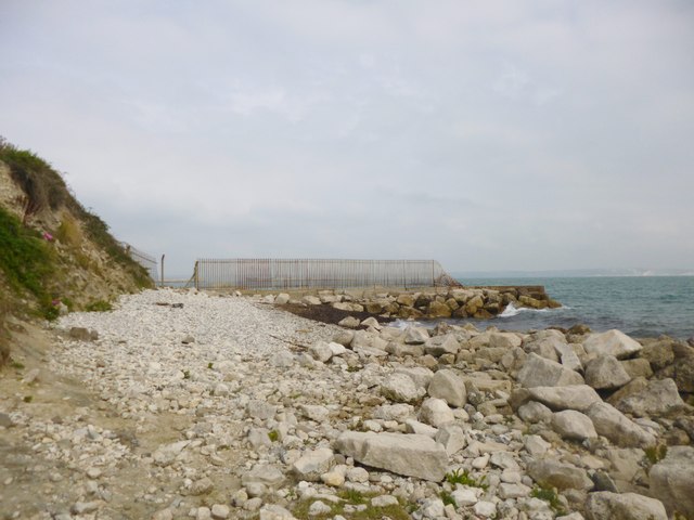
Castletown Beach is a picturesque coastal area located in Dorset, England. Situated near the town of Portland, this beach offers visitors a unique blend of natural beauty and historical significance.

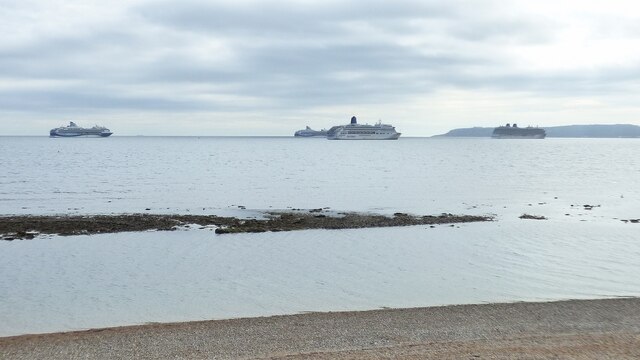
The beach itself stretches for approximately one mile, with fine golden sand that is perfect for sunbathing or leisurely walks along the shore. The crystal-clear waters of the English Channel provide a refreshing swimming experience for those looking to take a dip. The beach also benefits from being sheltered by the iconic Chesil Beach, which helps create a calm and peaceful atmosphere.

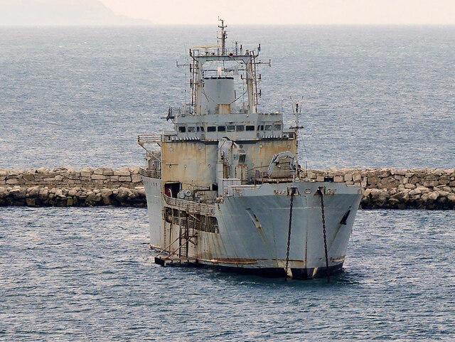
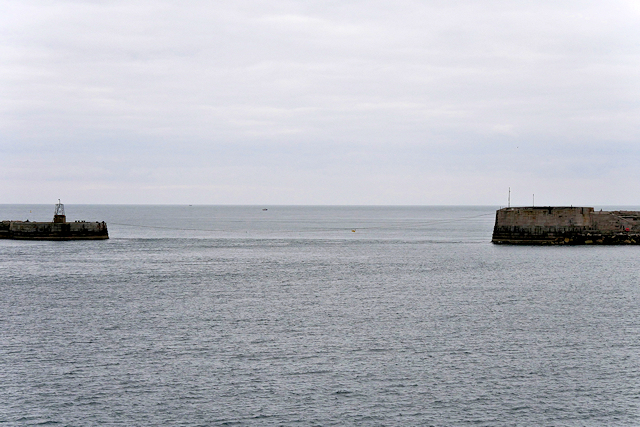
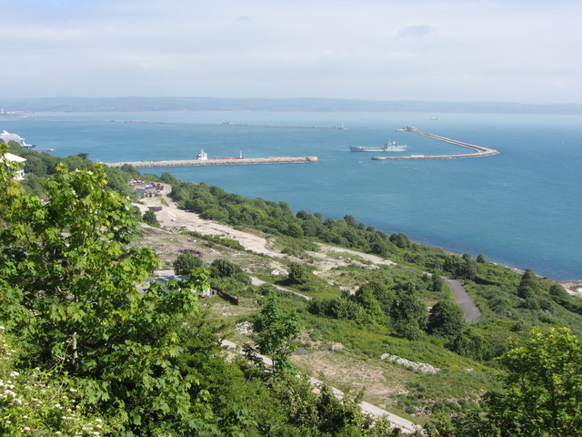
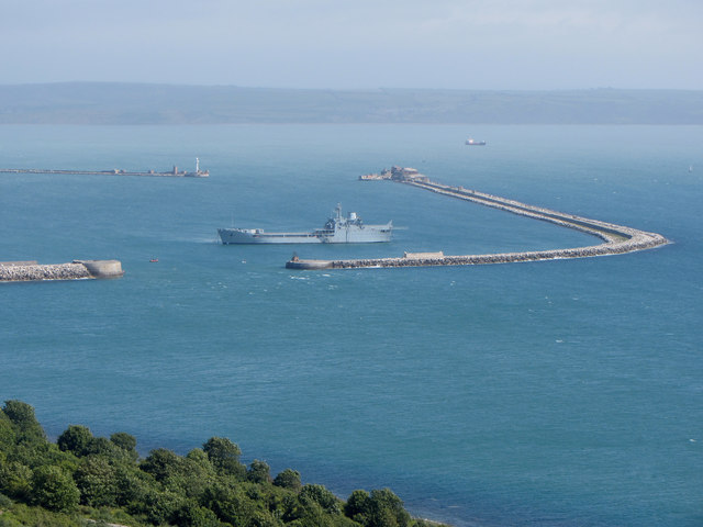
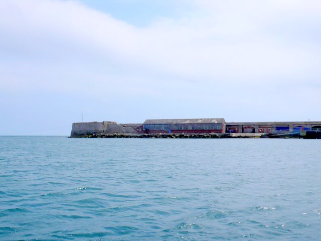
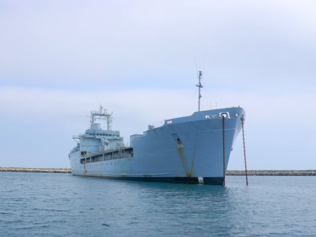
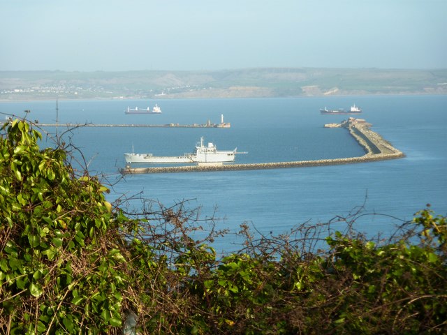
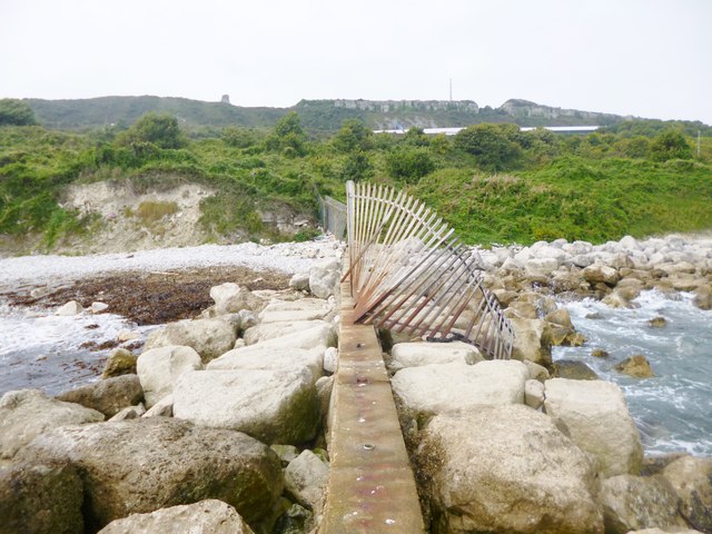
One of the main attractions of Castletown Beach is its close proximity to Portland Harbour, one of the largest man-made harbours in the world. This historic harbor has been used for centuries for various maritime activities, including fishing, sailing, and even hosting the sailing events of the 2012 Olympic Games. Visitors can witness the vibrant activity of boats and yachts coming and going from the harbor, adding to the beach's charm.

Castletown Beach is also known for its stunning views. From the beach, visitors can enjoy panoramic vistas of the Jurassic Coastline, a UNESCO World Heritage site renowned for its geological significance. The rugged cliffs, formed over millions of years, provide a dramatic backdrop to the beach and offer excellent opportunities for photography enthusiasts.

Facilities at Castletown Beach include ample parking, public toilets, and a nearby café serving refreshments. It is worth noting that the beach is relatively quiet compared to other popular tourist destinations in Dorset, making it an ideal spot for those seeking a more peaceful and relaxed coastal experience.

If you have any feedback on the listing, please let us know in the comments section below.

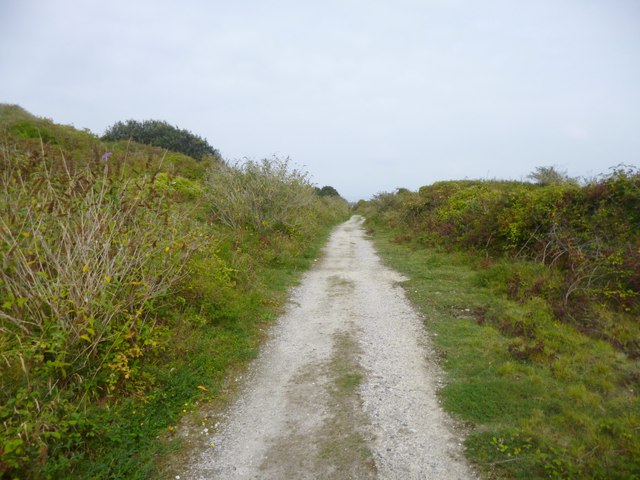
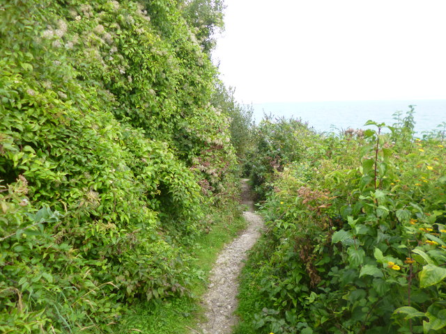
Castletown Beach Images

Images are sourced within 2km of 50.568533/-2.4422072 or Grid Reference SY6874. Thanks to Geograph Open Source API. All images are credited.

Portland Harbour, TV Sir Tristram (RFA Sir Tristram) Launched December 1966. RFA Sir Tristram was a Round Table class logistics landing ship (L3505) transferred to the Royal Fleet Auxiliary in 1970. She was badly damaged during the Falklands War of 1983 <span class="nowrap"><a title="https://en.wikipedia.org/wiki/Falklands_War" rel="nofollow ugc noopener" href="https://en.wikipedia.org/wiki/Falklands_War">Link</a><img style="margin-left:2px;" alt="External link" title="External link - shift click to open in new window" src="https://s1.geograph.org.uk/img/external.png" width="10" height="10"/></span> and needed to be rebuilt. After the re-build, she saw action in the Gulf War <span class="nowrap"><a title="https://en.wikipedia.org/wiki/Gulf_War" rel="nofollow ugc noopener" href="https://en.wikipedia.org/wiki/Gulf_War">Link</a><img style="margin-left:2px;" alt="External link" title="External link - shift click to open in new window" src="https://s1.geograph.org.uk/img/external.png" width="10" height="10"/></span> , and the Balkan conflicts <span class="nowrap"><a title="https://en.wikipedia.org/wiki/Yugoslav_Wars" rel="nofollow ugc noopener" href="https://en.wikipedia.org/wiki/Yugoslav_Wars">Link</a><img style="margin-left:2px;" alt="External link" title="External link - shift click to open in new window" src="https://s1.geograph.org.uk/img/external.png" width="10" height="10"/></span> of the 1990s. In 2003 the ship was deployed as part of the largest British fleet for 20 years in support of the invasion of Iraq <span class="nowrap"><a title="https://en.wikipedia.org/wiki/2003_invasion_of_Iraq" rel="nofollow ugc noopener" href="https://en.wikipedia.org/wiki/2003_invasion_of_Iraq">Link</a><img style="margin-left:2px;" alt="External link" title="External link - shift click to open in new window" src="https://s1.geograph.org.uk/img/external.png" width="10" height="10"/></span> . 

RFA Sir Tristram was decommissioned on 17 December 2005 but was converted to a Special Forces Training Vessel (TV Sir Tristram) in 2008 and is now moored permanently at Portland.

More information at <span class="nowrap"><a title="https://www.portlandhistory.co.uk/tv-tristram.html" rel="nofollow ugc noopener" href="https://www.portlandhistory.co.uk/tv-tristram.html">Link</a><img style="margin-left:2px;" alt="External link" title="External link - shift click to open in new window" src="https://s1.geograph.org.uk/img/external.png" width="10" height="10"/></span> (The Encyclopaedia of Portland History).
Portland Harbour, TV Sir Tristram (RFA Sir Tristram)
Launched December 1966. RFA Sir Tristram was a Round Table class logistics landing ship (L3505) transferred to the Royal Fleet Auxiliary in 1970. She was badly damaged during the Falklands War of 1983 LinkExternal link and needed to be rebuilt. After the re-build, she saw action in the Gulf War LinkExternal link , and the Balkan conflicts LinkExternal link of the 1990s. In 2003 the ship was deployed as part of the largest British fleet for 20 years in support of the invasion of Iraq LinkExternal link . RFA Sir Tristram was decommissioned on 17 December 2005 but was converted to a Special Forces Training Vessel (TV Sir Tristram) in 2008 and is now moored permanently at Portland. More information at LinkExternal link (The Encyclopaedia of Portland History).
Inner Pierhead Fort , Portland Harbour The remains of a Victorian fort at the South Ship Channel, one of the three entrances to Portland Harbour.

The Inner Pierhead Fort is situated on the end of the inner breakwater, which abuts from the dockyard of the harbour, on the northern face of the island. It was constructed 1859-1862, and is 100 feet in diameter. The inner breakwater is Grade II-Listed, and its designation includes the fort (List Entry Number: 1203106 <span class="nowrap"><a title="http://www.heritagegateway.org.uk/Gateway/Results_Single.aspx?uid=1203106&resourceID=5" rel="nofollow ugc noopener" href="http://www.heritagegateway.org.uk/Gateway/Results_Single.aspx?uid=1203106&resourceID=5">Link</a><img style="margin-left:2px;" alt="External link" title="External link - shift click to open in new window" src="https://s1.geograph.org.uk/img/external.png" width="10" height="10"/></span>  Heritage Gateway).
Inner Pierhead Fort , Portland Harbour
The remains of a Victorian fort at the South Ship Channel, one of the three entrances to Portland Harbour. The Inner Pierhead Fort is situated on the end of the inner breakwater, which abuts from the dockyard of the harbour, on the northern face of the island. It was constructed 1859-1862, and is 100 feet in diameter. The inner breakwater is Grade II-Listed, and its designation includes the fort (List Entry Number: 1203106 LinkExternal link Heritage Gateway).
Breakwater at Portland Harbour The South Ship Channel is on the right.
Breakwater at Portland Harbour
The South Ship Channel is on the right.
Portland Harbour, South Ship Channel One of three entrances through the sea wall/breakwater into Portland Harbour. It has a chain slung across it to prevent vessels entering.
Portland Harbour, South Ship Channel
One of three entrances through the sea wall/breakwater into Portland Harbour. It has a chain slung across it to prevent vessels entering.
South Ship Channel, Portland Harbour One of three entrances through the sea wall/breakwater into Portland Harbour. It has a chain slung across it to prevent vessels entering.
South Ship Channel, Portland Harbour
One of three entrances through the sea wall/breakwater into Portland Harbour. It has a chain slung across it to prevent vessels entering.
View towards Portland Harbour over East Weare
View over Portland Harbour
Cruise ships anchored outside Weymouth Harbour
Portland Inner Breakwater This shows the south ship channel entrance to Portland Harbour on the left. The breakwater is attached to the Island of Portland out of image to the right. A chain is extended across the opening to prevent vessels from using it.
Portland Inner Breakwater
This shows the south ship channel entrance to Portland Harbour on the left. The breakwater is attached to the Island of Portland out of image to the right. A chain is extended across the opening to prevent vessels from using it.
Sir Tristram This is the sister ship to Sir Galahad, destroyed in the Falklands. It sits just inside Portland Harbour by the South Ship Channel, the most southerly of the three entrances to the harbour. In the background is the breakwater. The ship is now used as a training ship
Sir Tristram
This is the sister ship to Sir Galahad, destroyed in the Falklands. It sits just inside Portland Harbour by the South Ship Channel, the most southerly of the three entrances to the harbour. In the background is the breakwater. The ship is now used as a training ship
Outer Breakwater Portland This shows the outer breakwater at Portland as the main subject and the Dorset Coast in the background. This view was taken from Grove Road in the North East side of Portland.
Outer Breakwater Portland
This shows the outer breakwater at Portland as the main subject and the Dorset Coast in the background. This view was taken from Grove Road in the North East side of Portland.
Five submarines! Photo c1935 5 submarines and a steam vessel, possibly Portland Harbour.
Five submarines!
Photo c1935 5 submarines and a steam vessel, possibly Portland Harbour.
Grove, railway trackbed Once Easton & Church Hope Railway, now a footpath to King's Pier. <span class="nowrap"><a title="http://en.wikipedia.org/wiki/Portland_Branch_Railway" rel="nofollow ugc noopener" href="http://en.wikipedia.org/wiki/Portland_Branch_Railway">Link</a><img style="margin-left:2px;" alt="External link" title="External link - shift click to open in new window" src="https://s1.geograph.org.uk/img/external.png" width="10" height="10"/></span>
Grove, railway trackbed
Once Easton & Church Hope Railway, now a footpath to King's Pier. LinkExternal link
Grove, footpath From <a href="https://www.geograph.org.uk/photo/4164756">SY7073 : Grove, railway trackbed</a> to King's Pier, through dogwood, buddleja and old man's beard scrub.
Grove, footpath
From SY7073 : Grove, railway trackbed to King's Pier, through dogwood, buddleja and old man's beard scrub.
East Weare, vegetation Buddleja, old man's beard, brambles, dogwood and the occasional sycamore on the lower reaches of Grove Cliff.
East Weare, vegetation
Buddleja, old man's beard, brambles, dogwood and the occasional sycamore on the lower reaches of Grove Cliff.
Grove, gate At the south-eastern boundary of Portland Port. Access seems disused; there is a hole in the gate, but apparently only scrub beyond.
Grove, gate
At the south-eastern boundary of Portland Port. Access seems disused; there is a hole in the gate, but apparently only scrub beyond.
Grove, King's Pier With C17 foundations, now concreted over. The fence marks the south-eastern boundary of Portland Port, but is poorly maintained - there is a gap where the fence has toppled over.
Grove, King's Pier
With C17 foundations, now concreted over. The fence marks the south-eastern boundary of Portland Port, but is poorly maintained - there is a gap where the fence has toppled over.
Grove, end of pier The end of <a href="https://www.geograph.org.uk/photo/4164848">SY7073 : Grove, King's Pier</a>, showing how the Portland Port (to the right) security fence has toppled.
Grove, end of pier
The end of SY7073 : Grove, King's Pier, showing how the Portland Port (to the right) security fence has toppled.
Show me another place!

Castletown Beach is located at Grid Ref: SY6874 (Lat: 50.568533, Lng: -2.4422072)

Unitary Authority: Dorset

Police Authority: Dorset

What 3 Words

///proved.bedding.trial. Near Portland, Dorset

Related Wikis

Castletown, Dorset

Castletown is a small village in Underhill on the Isle of Portland in Dorset. It is located close to Fortuneswell, on the shores of Portland Harbour, and...

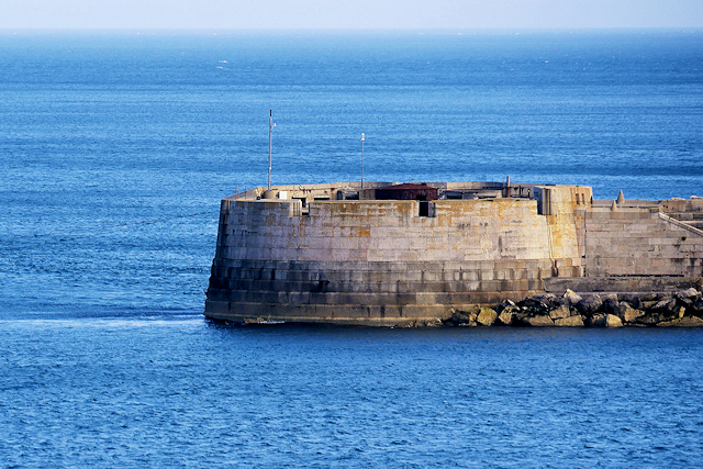
Mulberry Harbour Phoenix Units, Portland

The Portland Mulberry Harbour Phoenix Units are two reinforced concrete caissons, built as part of the artificial Mulberry harbours that were assembled...
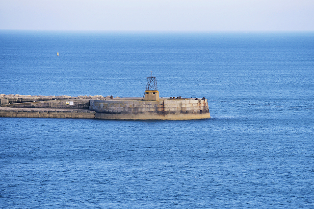
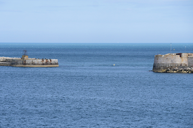
Phoenix breakwaters

The Phoenix breakwaters were a set of reinforced concrete caissons built as part of the artificial Mulberry harbours that were assembled as part of the...

Portland Castle

Portland Castle is an artillery fort constructed by Henry VIII on the Isle of Portland, Dorset, between 1539 and 1541. It formed part of the King's Device...

Nearby Amenities

Located within 500m of 50.568533,-2.4422072
Source: PGS
Lat/Long: 50.5683523/-2.4362285
Source: PGS
Lat/Long: 50.5681922/-2.4366115
Source: PGS
Lat/Long: 50.568295/-2.4374363
Source: PGS
Lat/Long: 50.5689027/-2.437292
Source: PGS
Lat/Long: 50.5695263/-2.439566
Source: PGS
Lat/Long: 50.5697822/-2.440385
Source: PGS
Lat/Long: 50.570023/-2.4409144
Source: PGS
Lat/Long: 50.5699006/-2.4410964
Source: PGS
Lat/Long: 50.5698427/-2.4409387
Source: PGS
Lat/Long: 50.5686982/-2.4412225
Source: PGS
Lat/Long: 50.5687052/-2.4417897
Source: PGS
Lat/Long: 50.5685649/-2.4426576
Source: PGS
Lat/Long: 50.5689875/-2.4426246
Source: PGS
Lat/Long: 50.5694431/-2.4425893
Source: PGS
Lat/Long: 50.5694795/-2.4434814
Source: PGS
Lat/Long: 50.56909/-2.443546
Source: PGS
Lat/Long: 50.5687831/-2.4435048
Crossing
Crossing: unmarked
Tactile Paving: yes
Lat/Long: 50.5677423/-2.4475544
Crossing
Crossing: uncontrolled
Lat/Long: 50.5681735/-2.4413163
Turning Circle
Lat/Long: 50.5653733/-2.4439008
Seamark Light Character: Fl
Seamark Light Colour: red
Seamark Light Height: 6
Seamark Light Period: 2
Seamark Light Range: 2
Seamark Light Reference: A 0334
Seamark Type: light_minor
Source: US NGA Pub. 114. 2011-05-26.
Lat/Long: 50.5722197/-2.4402535
Crossing
Crossing: uncontrolled
Lat/Long: 50.5678608/-2.4452381
Barrier: lift_gate
Bicycle: yes
Foot: yes
Lat/Long: 50.5681693/-2.4410024
Barrier: lift_gate
Bicycle: yes
Foot: yes
Lat/Long: 50.5676343/-2.4444697
Give Way
Direction: forward
Lat/Long: 50.5682536/-2.438499
Barrier: lift_gate
Lat/Long: 50.5681685/-2.4404597
Crossing
Crossing: uncontrolled
Lat/Long: 50.5701173/-2.437579
Barrier: lift_gate
Lat/Long: 50.5682837/-2.4404494
Give Way
Direction: forward
Lat/Long: 50.5683385/-2.4402039
Portland Hospital
Historic Railway: halt
Railway: site
Lat/Long: 50.5676509/-2.4441257
Royal Breakwater
Addr Postcode: DT5 1BD
Addr Street: Castletown
Fhrs Id: 992225
Source Addr: FHRS Open Data
Tourism: hotel
Wikidata: Q26500663
Lat/Long: 50.5681263/-2.4433985
Give Way
Direction: forward
Lat/Long: 50.5664438/-2.4466803
Barrier: entrance
Lat/Long: 50.5683217/-2.4474866
Osprey Leisure Centre
Addr Postcode: DT5 1BD
Contact Facebook: Ospreylc
Email: info@ospreyleisure.co.uk
Leisure: sports_centre
Phone: +44 1305 824378
Sport: multi
Website: https://ospreyleisure.co.uk/
Lat/Long: 50.5681279/-2.4453166
Cafe
Legacy Cafe
Addr Postcode: DT5 1BD
Addr Street: Castletown
Fhrs Id: 992776
Source Addr: FHRS Open Data
Lat/Long: 50.5680571/-2.4452678
Hairport
Shop: hairdresser
Lat/Long: 50.5680904/-2.4450988
Pub
The Wreck Bar
Lat/Long: 50.5683963/-2.4433735
Cafe
The Aqua Cafe
Lat/Long: 50.5684824/-2.443212
Clark's Boatworks
Waterway: boatyard
Lat/Long: 50.5688461/-2.4430644
Pub
The Albert
Lat/Long: 50.568094/-2.4421626
Post Box
Ref: DT5 65
Ref GB Uprn: 10015451227
Lat/Long: 50.5679693/-2.4447309
Crossing
Crossing: uncontrolled
Lat/Long: 50.5679113/-2.4453147
Give Way
Direction: forward
Lat/Long: 50.5672435/-2.4460992
Give Way
Direction: backward
Lat/Long: 50.5646172/-2.4436299
Fixme: Continue
Lat/Long: 50.5679055/-2.4463249
Barrier: entrance
Lat/Long: 50.5679709/-2.4469574
Shop: gift
Lat/Long: 50.5680469/-2.4470839
Castletown
Place: village
Wikidata: Q5050649
Wikipedia: en:Castletown, Dorset
Lat/Long: 50.5679558/-2.4441122
Portland
Place: suburb
Lat/Long: 50.5672516/-2.4472529
Castletown D-Day Centre
Addr Postcode: DT5 1BD
Contact Facebook: castletownddaycentre
Opening Hours: We-Su 10:30-15:30
Phone: +44 1305 443444
Tourism: museum
Website: https://ddaycentre.com/
Lat/Long: 50.5684755/-2.4440165
Crossing
Crossing: unmarked
Tactile Paving: yes
Lat/Long: 50.5670415/-2.4461672
Crossing
Crossing: unmarked
Lat/Long: 50.5672564/-2.4461368
Crossing
Crossing: unmarked
Tactile Paving: yes
Lat/Long: 50.5667706/-2.4482935
Give Way
Direction: forward
Lat/Long: 50.5653162/-2.4463015
Barrier: entrance
Lat/Long: 50.5650181/-2.4466127
Fixme: continue
Lat/Long: 50.5664182/-2.4455778
Crossing
Crossing: unmarked
Tactile Paving: yes
Lat/Long: 50.5657542/-2.4454218
Crossing
Crossing: unmarked
Tactile Paving: yes
Lat/Long: 50.5651569/-2.4466285
Crossing
Crossing: unmarked
Tactile Paving: yes
Lat/Long: 50.5651395/-2.4464635
Entrance: yes
Lat/Long: 50.5657338/-2.4445401
Entrance: yes
Lat/Long: 50.5656073/-2.4447335
Entrance: yes
Lat/Long: 50.5651723/-2.4456251
Give Way
Direction: forward
Lat/Long: 50.5651483/-2.4464716
Crossing
Crossing: uncontrolled
Tactile Paving: yes
Lat/Long: 50.5664842/-2.4465382
Crossing
Crossing: uncontrolled
Tactile Paving: yes
Lat/Long: 50.5664093/-2.4466467
Crossing
Crossing: uncontrolled
Lat/Long: 50.5681391/-2.4378723
Crossing
Crossing: uncontrolled
Lat/Long: 50.5686517/-2.4391178
Barrier: entrance
Lat/Long: 50.5686133/-2.4390976
Generator Method: photovoltaic
Generator Output Electricity: yes
Generator Source: solar
Generator Type: solar_photovoltaic_panel
Location: roof
Power: generator
Lat/Long: 50.5680661/-2.4423619
Generator Method: photovoltaic
Generator Output Electricity: yes
Generator Source: solar
Generator Type: solar_photovoltaic_panel
Location: roof
Power: generator
Lat/Long: 50.5680644/-2.4422653
Give Way
Direction: forward
Lat/Long: 50.5685128/-2.4400243
Crossing
Crossing: uncontrolled
Lat/Long: 50.5684406/-2.4400922
Give Way
Direction: backward
Lat/Long: 50.5645041/-2.4430524
Give Way
Direction: backward
Lat/Long: 50.5649979/-2.4422059
Give Way
Direction: forward
Lat/Long: 50.5644683/-2.4415057
Barrier: entrance
Lat/Long: 50.5651867/-2.4381111
Historic: naval_mine
Tourism: attraction
Lat/Long: 50.5683208/-2.4440865
Telephone
Booth: K6
Covered: booth
Lat/Long: 50.5683384/-2.4440632
M4 Sherman
Historic: tank
Tank Model: M4 Sherman
Tank Model Wikipedia: https://en.wikipedia.org/wiki/M4_Sherman
Lat/Long: 50.5683143/-2.443956
Castleton Junction
Historic Railway: junction
Railway: site
Lat/Long: 50.566451/-2.446167
Post Box
Collection Times: Mo-Fr 09:00; Sa 07:00
Operator: Royal Mail
Post Box Type: wall
Ref: DT5 42D
Ref GB Uprn: 10015315007
Royal Cypher: VR
Royal Cypher Wikidata: Q33102356
Source: survey; Bing
Survey Date: 2022-11-11
Lat/Long: 50.5652858/-2.4464471
Bus Stop
Portland Castle
Bus: yes
Naptan AtcoCode: 1200DOA90811
Naptan Bearing: SE
Naptan CommonName: Portland Castle
Naptan Indicator: SE-bound
Naptan NaptanCode: dordpjmw
Naptan PlusbusZoneRef: WEYMTH
Naptan Street: Mulberry Avenue
Naptan Verified: no
Network: Wessex (First Bus)
Public Transport: platform
Lat/Long: 50.5676043/-2.4470429
Bus Stop
Portland Castle
Bus: yes
Network: Wessex (First Bus)
Public Transport: platform
Lat/Long: 50.5673564/-2.4466049
The data included in this document is from www.openstreetmap.org. The data is made available under ODbL.

Have you been to Castletown Beach?

Leave your review of Castletown Beach below (or comments, questions and feedback).