Mill Sand

Beach in Orkney

Scotland

Mill Sand

Swartabreck East Orkney farmland.
Swartabreck Credit: Richard Webb

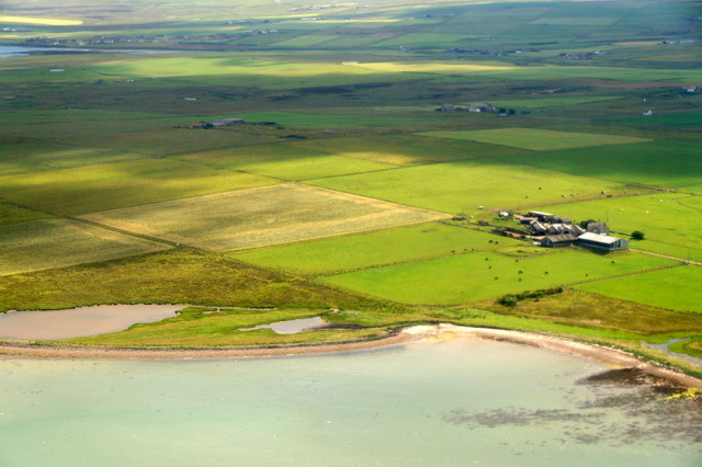
Mill Sand is a picturesque beach nestled on the north coast of Orkney, a collection of islands located off the northeastern coast of Scotland. It is a popular destination for both locals and tourists due to its stunning natural beauty and tranquil atmosphere. The beach is named after the nearby Mill of Brogan, a historic watermill that once operated in the area.

Stretching over half a mile, Mill Sand boasts golden sands that gently slope into the clear blue waters of the North Sea. The beach is known for its unspoiled and pristine surroundings, offering visitors a peaceful retreat away from the hustle and bustle of everyday life. Its remote location also means that it is often less crowded than other beaches in the region, allowing for a more secluded and intimate experience.

Mill Sand is a haven for wildlife enthusiasts, as the surrounding dunes and grassy areas are home to a variety of bird species, including curlews and oystercatchers. The beach offers breathtaking panoramic views of the rugged coastline, with dramatic cliffs and sea stacks adding to its charm.

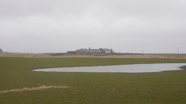
Visitors to Mill Sand can enjoy various activities such as beachcombing, picnicking, and leisurely walks along the shore. The beach is also a popular spot for wildlife watching, with seals often seen basking on nearby rocks. However, it is important to note that swimming is not recommended due to strong currents and chilly temperatures.

Overall, Mill Sand is a hidden gem in the Orkney Islands, offering visitors a serene and untouched coastal experience amidst stunning natural beauty.

If you have any feedback on the listing, please let us know in the comments section below.

Mill Sand Images

Images are sourced within 2km of 58.953256/-2.8427079 or Grid Reference HY5107. Thanks to Geograph Open Source API. All images are credited.

Swartabreck East Orkney farmland.
Swartabreck
East Orkney farmland.
Messigate, Tankerness, from the air Loch of Messigate on the left and Mill Sand in the foreground.
Messigate, Tankerness, from the air
Loch of Messigate on the left and Mill Sand in the foreground.
Jewellery workshop Orkney has a rich jewellery heritage, from the early designs of Ola Gorie (the first to produce jewellery here since Viking times) to popular local producers Sheila Fleet, Aurora Orkney, Ortak and several smaller firms. Mainland Orkney is home to several of these jewellery manufacturers; this is the headquarters of the Sheila Fleet jewellery business.
Jewellery workshop
Orkney has a rich jewellery heritage, from the early designs of Ola Gorie (the first to produce jewellery here since Viking times) to popular local producers Sheila Fleet, Aurora Orkney, Ortak and several smaller firms. Mainland Orkney is home to several of these jewellery manufacturers; this is the headquarters of the Sheila Fleet jewellery business.
Delicate craftmanship A girl applying rainbow enamel colouring to a ring in the Sheila Fleet atelier in Tankerness.
Delicate craftmanship
A girl applying rainbow enamel colouring to a ring in the Sheila Fleet atelier in Tankerness.
Showroom at the atelier Jewellery showroom and shop at the Sheila Fleet factory,
Showroom at the atelier
Jewellery showroom and shop at the Sheila Fleet factory,
Mill Sand With the tide in.
Mill Sand
With the tide in.
Willow Vale, Tankerness House at a T-junction close to a land-fill site.
Willow Vale, Tankerness
House at a T-junction close to a land-fill site.
White horses With the Loch of Tankerness in the background.
White horses
With the Loch of Tankerness in the background.
St. Andrew's Kirk, Tankerness St. Andrew's Kirk (North Church) Church of Scotland, Tankerness. Historic Scotland C Listed ID 352630. Built 1801, enlarged 1827.
St. Andrew's Kirk, Tankerness
St. Andrew's Kirk (North Church) Church of Scotland, Tankerness. Historic Scotland C Listed ID 352630. Built 1801, enlarged 1827.
Tankerness Meal Mill Meal Mill. Historic Scotland B Listed (Ident-18567). Early 19th Century.

2-storey, 5-bay T-plan asymmetrical mill with slightly raised kiln at E end and undershot water wheel at W. Harl-pointed rubble. Long and short quoins to kiln. The tall blocked arches mark the position of the original wheel before it was placed on the outside of the end wall.

3 pairs of stones were driven by a high-breast wheel about 4.3m in diameter and, in order that the movement of the wheel did not startle horses passing over the adjacent bridge, it was shielded by a screen wall.(Historic Scotland)
Tankerness Meal Mill
Meal Mill. Historic Scotland B Listed (Ident-18567). Early 19th Century. 2-storey, 5-bay T-plan asymmetrical mill with slightly raised kiln at E end and undershot water wheel at W. Harl-pointed rubble. Long and short quoins to kiln. The tall blocked arches mark the position of the original wheel before it was placed on the outside of the end wall. 3 pairs of stones were driven by a high-breast wheel about 4.3m in diameter and, in order that the movement of the wheel did not startle horses passing over the adjacent bridge, it was shielded by a screen wall.(Historic Scotland)
Hall of Tankerness, from the air
Houses at Tankerness, from the air
Houses at Bossack, Tankerness, from the air
Tankerness farmland Wet and rashy, fields beside the Loch of Tankerness.
Tankerness farmland
Wet and rashy, fields beside the Loch of Tankerness.
Hedge, Hall of Tankerness Offering a bit more shelter than the usual barbed wire.
Hedge, Hall of Tankerness
Offering a bit more shelter than the usual barbed wire.
Wet fields, Tankerness Starting to green up after a long Winter.
Wet fields, Tankerness
Starting to green up after a long Winter.
St. Andrew's Kirk, Tankerness Now a jewellery workshop and gallery.
St. Andrew's Kirk, Tankerness
Now a jewellery workshop and gallery.
Flooded field, Hawell Pasture, Tankerness
Flooded field, Hawell
Pasture, Tankerness
Show me another place!

Mill Sand is located at Grid Ref: HY5107 (Lat: 58.953256, Lng: -2.8427079)

Unitary Authority: Orkney Islands

Police Authority: Highlands and Islands

What 3 Words

///locator.estimates.spent. Near Tankerness, Orkney Islands

Related Wikis

Tankerness

Tankerness is a district in the St Andrews parish in Mainland, Orkney, Scotland. Essentially a peninsula, it is about 13 kilometres (8 mi) south-east of...

Toab, Orkney

Toab is a parish on the Orkney Mainland, situated in the East Mainland. Toab is located off the A960 road at the head of Deer Sound on the Mainland, Orkney...

St Andrews, Orkney

St Andrews is a parish on Mainland, Orkney in Scotland. It is located east of the town of Kirkwall and the parish of St Ola and lies north of Holm and...

Loch of Tankerness

Loch of Tankerness is a large, lowland, freshwater loch on the Orkney mainland in Scotland. The loch is roughly triangular in shape and is shallow with...

Mine Howe

Mine Howe is an Iron Age subterranean man-made chamber dug 6 meters (20 feet) deep inside a large mound. It is located in the Tankerness area of Orkney...

Kirkwall Airport

Kirkwall Airport (IATA: KOI, ICAO: EGPA) (Scottish Gaelic: Port-adhair Bhaile na h-Eaglais) is the main airport serving Orkney in Scotland. It is located...

St Peter's Pool, Orkney

St Peter's Pool is a bay in the East Mainland of Orkney, Scotland. This bay was the site of significant coastal defences during World War II, when a German...

Holm, Orkney

Holm (pronounced /hæm/ ), also spelled Ham, is a parish on Mainland, Orkney.An adjacent Sound, running between Mainland, and Burray, is named after Holm...

Nearby Amenities

Located within 500m of 58.953256,-2.8427079
Toab Skerry
Place: locality
Lat/Long: 58.9537338/-2.8406118
Post Box
Brand: Royal Mail
Brand Wikidata: Q638098
Collection Times: Mo-Fr 11:15; Sa 11:15
Operator: Royal Mail
Operator Wikidata: Q638098
Post Box Type: lamp
Ref: KW17 36
Royal Cypher: scottish_crown
Lat/Long: 58.9521178/-2.8495769
Power: pole
Lat/Long: 58.9514615/-2.8486303
Power: pole
Lat/Long: 58.9510259/-2.8479717
Power: pole
Lat/Long: 58.9504659/-2.8471322
Power: pole
Lat/Long: 58.9499512/-2.8463631
Power: pole
Lat/Long: 58.9493976/-2.8455412
The data included in this document is from www.openstreetmap.org. The data is made available under ODbL.

Have you been to Mill Sand?

Leave your review of Mill Sand below (or comments, questions and feedback).