Conwy Sands

Beach in Caernarfonshire

Wales

Conwy Sands

Walking on Conwy Sands The River Conway (Afon Conwy) rises on the Migneint Moors and flows northward for 27 miles to its mouth at Conwy.
Wikipedia: <span class="nowrap"><a title="http://en.wikipedia.org/wiki/River_Conwy" rel="nofollow ugc noopener" href="http://en.wikipedia.org/wiki/River_Conwy">Link</a><img style="margin-left:2px;" alt="External link" title="External link - shift click to open in new window" src="https://s1.geograph.org.uk/img/external.png" width="10" height="10"/></span>
Walking on Conwy Sands Credit: Mat Fascione

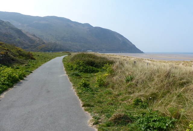
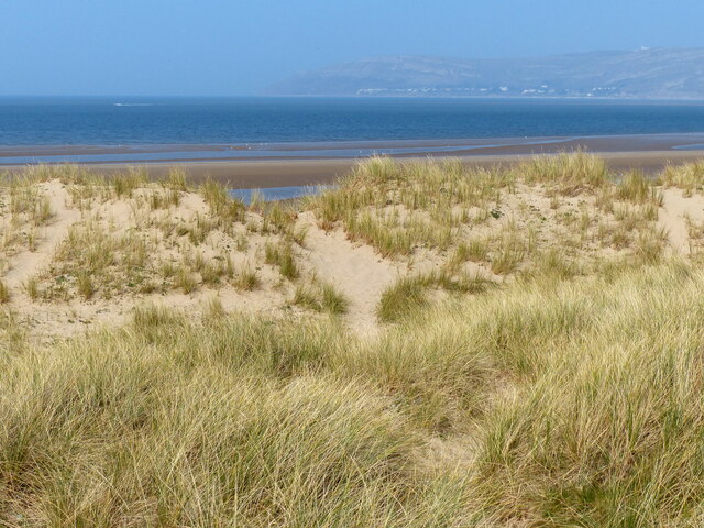
Conwy Sands is a stunning beach located in Caernarfonshire, Wales. It stretches for approximately 3 miles along the North Wales coast, offering visitors a picturesque and tranquil setting. With its golden sand and clear blue waters, Conwy Sands is a popular destination for both locals and tourists alike.

The beach is situated near the historic town of Conwy, which is renowned for its medieval castle and town walls. This makes Conwy Sands an ideal spot for those looking to combine a beach trip with a cultural experience.

Conwy Sands is known for its excellent water quality and has been awarded the Blue Flag status, ensuring visitors can enjoy a clean and safe environment. The beach is also backed by sand dunes, providing a natural barrier and adding to the scenic beauty of the area.

During low tide, the beach reveals vast expanses of sand, perfect for long walks or a spot of beachcombing. The sand is soft and inviting, making it an ideal spot for families to relax and build sandcastles. The waters are relatively calm, making it suitable for swimming and water activities such as kayaking and paddleboarding.

Facilities at Conwy Sands include car parking, toilets, and nearby cafes and restaurants. The beach is easily accessible, with a promenade running along its length, offering stunning views of the surrounding landscape.

Overall, Conwy Sands offers visitors a beautiful and peaceful beach experience, combined with the opportunity to explore the nearby historic town of Conwy. Whether you're seeking relaxation or adventure, this beach is sure to delight all who visit.

If you have any feedback on the listing, please let us know in the comments section below.

Conwy Sands Images

Images are sourced within 2km of 53.304734/-3.8681087 or Grid Reference SH7580. Thanks to Geograph Open Source API. All images are credited.

Walking on Conwy Sands The River Conway (Afon Conwy) rises on the Migneint Moors and flows northward for 27 miles to its mouth at Conwy.
Wikipedia: <span class="nowrap"><a title="http://en.wikipedia.org/wiki/River_Conwy" rel="nofollow ugc noopener" href="http://en.wikipedia.org/wiki/River_Conwy">Link</a><img style="margin-left:2px;" alt="External link" title="External link - shift click to open in new window" src="https://s1.geograph.org.uk/img/external.png" width="10" height="10"/></span>
Walking on Conwy Sands
The River Conway (Afon Conwy) rises on the Migneint Moors and flows northward for 27 miles to its mouth at Conwy. Wikipedia: LinkExternal link
Conwy Sands at the mouth of the River Conwy The River Conway (Afon Conwy) rises on the Migneint Moors and flows northward for 27 miles to its mouth at Conwy.
Wikipedia: <span class="nowrap"><a title="http://en.wikipedia.org/wiki/River_Conwy" rel="nofollow ugc noopener" href="http://en.wikipedia.org/wiki/River_Conwy">Link</a><img style="margin-left:2px;" alt="External link" title="External link - shift click to open in new window" src="https://s1.geograph.org.uk/img/external.png" width="10" height="10"/></span>
Conwy Sands at the mouth of the River Conwy
The River Conway (Afon Conwy) rises on the Migneint Moors and flows northward for 27 miles to its mouth at Conwy. Wikipedia: LinkExternal link
Conwy Sands and the River Conwy The River Conway (Afon Conwy) rises on the Migneint Moors and flows northward for 27 miles to its mouth at Conwy.
Wikipedia: <span class="nowrap"><a title="http://en.wikipedia.org/wiki/River_Conwy" rel="nofollow ugc noopener" href="http://en.wikipedia.org/wiki/River_Conwy">Link</a><img style="margin-left:2px;" alt="External link" title="External link - shift click to open in new window" src="https://s1.geograph.org.uk/img/external.png" width="10" height="10"/></span>
Conwy Sands and the River Conwy
The River Conway (Afon Conwy) rises on the Migneint Moors and flows northward for 27 miles to its mouth at Conwy. Wikipedia: LinkExternal link
Shoreline at Conwy Sands
Old sea defences at Conwy Morfa
Path through the dunes at Conwy Morfa
Wales Coast Path at Conwy Morfa The Wales Coast Path (Welsh: Llwybr Arfordir Cymru) is a long distance footpath which follows the whole of the coastline of Wales. It opened on 5 May 2012, and offers a 870 mile long route from Chepstow in the south to Queensferry in the north.
Wales is the first country in the world to provide a dedicated footpath along its entire coastline. The Path runs through eleven National Nature Reserves and other nature reserves, including those managed by The Wildlife Trusts or Royal Society for the Protection of Birds (RSPB).
Logo can be seen at<a href="https://www.geograph.org.uk/photo/3738617">SS0897 : Logo, Wales Coast Path</a>.
Website: <span class="nowrap"><a title="http://www.walescoastpath.gov.uk/default.aspx" rel="nofollow ugc noopener" href="http://www.walescoastpath.gov.uk/default.aspx">Link</a><img style="margin-left:2px;" alt="External link" title="External link - shift click to open in new window" src="https://s1.geograph.org.uk/img/external.png" width="10" height="10"/></span>
Wales Coast Path at Conwy Morfa
The Wales Coast Path (Welsh: Llwybr Arfordir Cymru) is a long distance footpath which follows the whole of the coastline of Wales. It opened on 5 May 2012, and offers a 870 mile long route from Chepstow in the south to Queensferry in the north. Wales is the first country in the world to provide a dedicated footpath along its entire coastline. The Path runs through eleven National Nature Reserves and other nature reserves, including those managed by The Wildlife Trusts or Royal Society for the Protection of Birds (RSPB). Logo can be seen atSS0897 : Logo, Wales Coast Path. Website: LinkExternal link
Wales Coast Path towards Penmaen-bach Point The Wales Coast Path (Welsh: Llwybr Arfordir Cymru) is a long distance footpath which follows the whole of the coastline of Wales. It opened on 5 May 2012, and offers a 870 mile long route from Chepstow in the south to Queensferry in the north.
Wales is the first country in the world to provide a dedicated footpath along its entire coastline. The Path runs through eleven National Nature Reserves and other nature reserves, including those managed by The Wildlife Trusts or Royal Society for the Protection of Birds (RSPB).
Logo can be seen at<a href="https://www.geograph.org.uk/photo/3738617">SS0897 : Logo, Wales Coast Path</a>.
Website: <span class="nowrap"><a title="http://www.walescoastpath.gov.uk/default.aspx" rel="nofollow ugc noopener" href="http://www.walescoastpath.gov.uk/default.aspx">Link</a><img style="margin-left:2px;" alt="External link" title="External link - shift click to open in new window" src="https://s1.geograph.org.uk/img/external.png" width="10" height="10"/></span>
Wales Coast Path towards Penmaen-bach Point
The Wales Coast Path (Welsh: Llwybr Arfordir Cymru) is a long distance footpath which follows the whole of the coastline of Wales. It opened on 5 May 2012, and offers a 870 mile long route from Chepstow in the south to Queensferry in the north. Wales is the first country in the world to provide a dedicated footpath along its entire coastline. The Path runs through eleven National Nature Reserves and other nature reserves, including those managed by The Wildlife Trusts or Royal Society for the Protection of Birds (RSPB). Logo can be seen atSS0897 : Logo, Wales Coast Path. Website: LinkExternal link
Sand dunes along Conwy Sands Looking north across 3 miles of Conwy Bay towards Great Orme's Head.
Sand dunes along Conwy Sands
Looking north across 3 miles of Conwy Bay towards Great Orme's Head.
Seat and sculptures along the Wales Coast Path The sculptures are Llywelyn the Great, Thomas Telford and Margaret Williams.
In the background is Conwy Mountain.
Seat and sculptures along the Wales Coast Path
The sculptures are Llywelyn the Great, Thomas Telford and Margaret Williams. In the background is Conwy Mountain.
Conwy Sands near Penmaen-bach Point
Penmaen-bach Point The North Wales Coast Railway Line, the Wales Coast Path, and the A55 North Wales Expressway heading towards Penmaen-bach Point.
Penmaen-bach Point
The North Wales Coast Railway Line, the Wales Coast Path, and the A55 North Wales Expressway heading towards Penmaen-bach Point.
Wales Coast Path at Penmaen-bach Point The path is running alongside the eastbound A55 North Wales Expressway.
Wales Coast Path at Penmaen-bach Point
The path is running alongside the eastbound A55 North Wales Expressway.
Wales Coast Path at Penmaen-bach Point The path is running alongside the eastbound A55 North Wales Expressway at the Penmaen-bach Tunnel.
Wales Coast Path at Penmaen-bach Point
The path is running alongside the eastbound A55 North Wales Expressway at the Penmaen-bach Tunnel.
Distant quadbikes on Conwy sands These quadbikers weren't roaring around for sport, but were clearly visiting the beach for some other purpose - our guess was that they were digging for fishing bait. As we were at our turn-round point with limited time, we couldn't investigate further, but it definitely wasn't a day for hanging around on the beach. This is summer in the UK, with some vicious showers and a biting wind, and low cloud scudding over Penmaen-back Point. A day for wellies and kagoules, not flip-flops and bikinis.
Distant quadbikes on Conwy sands
These quadbikers weren't roaring around for sport, but were clearly visiting the beach for some other purpose - our guess was that they were digging for fishing bait. As we were at our turn-round point with limited time, we couldn't investigate further, but it definitely wasn't a day for hanging around on the beach. This is summer in the UK, with some vicious showers and a biting wind, and low cloud scudding over Penmaen-back Point. A day for wellies and kagoules, not flip-flops and bikinis.
Ripple marks on Conwy Sands With the tide out, a large area of sand is exposed, uniformly covered in ripple marks but few footprints. This is summer in Wales, with a biting wind, and vicious showers - two minutes after this, all sign of blue sky had vanished and ten minutes on, we were beating a hasty retreat from just a few metres into the next grid square (not soon enough, even clad in waterproofs and wellies we got pretty wet).
Ripple marks on Conwy Sands
With the tide out, a large area of sand is exposed, uniformly covered in ripple marks but few footprints. This is summer in Wales, with a biting wind, and vicious showers - two minutes after this, all sign of blue sky had vanished and ten minutes on, we were beating a hasty retreat from just a few metres into the next grid square (not soon enough, even clad in waterproofs and wellies we got pretty wet).
West shore breakwater about to succumb to the incoming tide The breakwater ensures that this gridsquare is accessible even at high tide, if the weather is fit enough to avoid the feature serving its intended purpose of breaking waves coming from Irish Sea swells. An area of foreshore beyond it is quite rocky (unlike the rather shifting sands further out where tourists are apt to become trapped by the rising tide in summer).
West shore breakwater about to succumb to the incoming tide
The breakwater ensures that this gridsquare is accessible even at high tide, if the weather is fit enough to avoid the feature serving its intended purpose of breaking waves coming from Irish Sea swells. An area of foreshore beyond it is quite rocky (unlike the rather shifting sands further out where tourists are apt to become trapped by the rising tide in summer).
Penmaen-bach Point With a strong westerly wind blowing, this is one of the few moments when we weren't being blasted by a cloud of abrasive blown sand which, by the time we'd got this close to the point, was starting to reach head height in the gusts, making for an uncomfortable experience. The beach gets narrower round the headland, and the noisy A55 road much closer, so as a fun place to walk the dogs, this was about the limit.
Penmaen-bach Point
With a strong westerly wind blowing, this is one of the few moments when we weren't being blasted by a cloud of abrasive blown sand which, by the time we'd got this close to the point, was starting to reach head height in the gusts, making for an uncomfortable experience. The beach gets narrower round the headland, and the noisy A55 road much closer, so as a fun place to walk the dogs, this was about the limit.
Show me another place!

Conwy Sands is located at Grid Ref: SH7580 (Lat: 53.304734, Lng: -3.8681087)

Unitary Authority: Conwy

Police Authority: North Wales

What 3 Words

///exploring.helps.that. Near Deganwy, Conwy

Nearby Locations

Conwy Sands

Related Wikis

Morfa Conwy

Morfa Conwy is a spit formed originally of marshy sand, north of the western end of the modern A55 entrance to Conwy in Conwy county borough, north-west...

Conwy Golf Club

Conwy Golf Club in Conwy, Wales was officially opened as Caernarfonshire Golf Club in 1890. The links course on the Morfa Conwy peninsula was designed...

2021 Curtis Cup

The 41st Curtis Cup Match was played from 26–28 August 2021 at Conwy Golf Club near Conwy, Wales. It was originally scheduled for 12–14 June 2020 but was...

Conway Marsh railway station

Conway Marsh railway station (later known as Conway Morfa) was located about a mile north west of Conwy, Wales (Conway being the English name for the town...

Have you been to Conwy Sands?

Leave your review of Conwy Sands below (or comments, questions and feedback).