Beaks Horn

Beach in Cornwall

England

Beaks Horn

On coastal path, E of Downderry
On coastal path, E of Downderry Credit: Colin Park

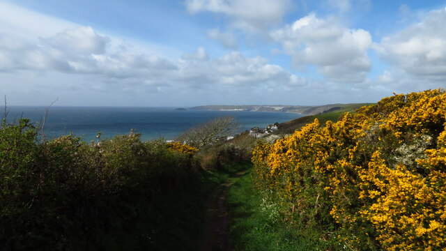
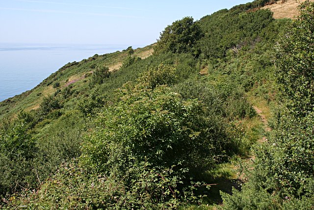
Beaks Horn is a picturesque beach located in Cornwall, England. It is known for its stunning cliffs, golden sands, and crystal-clear waters. The beach is surrounded by rugged cliffs, providing a dramatic backdrop to the tranquil waters below.

Beaks Horn is a popular spot for sunbathing, picnicking, and swimming. The beach is also a great place for wildlife enthusiasts, as it is home to a variety of bird species and marine life. Visitors may spot seabirds soaring above the cliffs, or seals basking in the sun on the rocks.

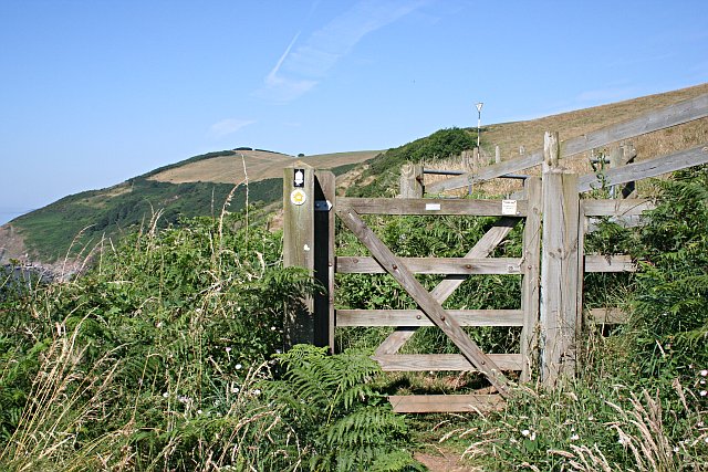
The beach is accessible by a steep path leading down from the cliffs above, making it a secluded and peaceful spot away from the hustle and bustle of more crowded beaches. Beaks Horn is a great place to relax and unwind, surrounded by the natural beauty of the Cornish coast.

Overall, Beaks Horn is a hidden gem in Cornwall, offering stunning views, peaceful surroundings, and a chance to connect with nature. It is a must-visit destination for anyone looking to experience the beauty of the English coastline.

If you have any feedback on the listing, please let us know in the comments section below.

Beaks Horn Images

Images are sourced within 2km of 50.361731/-4.3308967 or Grid Reference SX3453. Thanks to Geograph Open Source API. All images are credited.

On coastal path, E of Downderry
On SW Coast Path heading towards Portwrinkle
View W to Portwrinkle from SW Coast Path
Finneygook Beach, Portwrinkle Looking Seaward (South) from the rockpools.
Finneygook Beach, Portwrinkle
Looking Seaward (South) from the rockpools.
Downderry - east side, from Battern Cliffs A zoomed shot from an adjacent grid square gives a view of Downderry which emphasises its location on a precarious platform of soft rock above the sea.
Downderry - east side, from Battern Cliffs
A zoomed shot from an adjacent grid square gives a view of Downderry which emphasises its location on a precarious platform of soft rock above the sea.
Whitsand Bay Portwrinkle to Rame Head. Taken from a point close by the B3247 road to the west of Portwrinkle
Whitsand Bay
Portwrinkle to Rame Head. Taken from a point close by the B3247 road to the west of Portwrinkle
Portwrinkle This photograph of the small coastal village of Portwrinkle was taken from the hillside adjacent to Finnygook lane. The photograph shows the 20th century development of the village including a large hotel.  The area of Portwrinkle which formed the original fishing village is at the western end of the village, just out of sight on this shot.
Portwrinkle
This photograph of the small coastal village of Portwrinkle was taken from the hillside adjacent to Finnygook lane. The photograph shows the 20th century development of the village including a large hotel. The area of Portwrinkle which formed the original fishing village is at the western end of the village, just out of sight on this shot.
Valley to the north of Trewrickle Farm.
Old farm buildings at Tredrossel Conversions are taking place, the farthest building has been converted into cottages.
Old farm buildings at Tredrossel
Conversions are taking place, the farthest building has been converted into cottages.
Houses on the Seafront Road This is at the western end of Portwrinkle, the site of the old village.  The white house in the foreground called "Smuggler's Cottage" is probably the oldest house in the village.  It has a date mark of 1795 on the front.  In the 17th and early 18th century it is likely that almost all male residents of the village took part in smuggling from time to time as it was one way to supplement the meagre income from the pilchard fishery.
Houses on the Seafront Road
This is at the western end of Portwrinkle, the site of the old village. The white house in the foreground called "Smuggler's Cottage" is probably the oldest house in the village. It has a date mark of 1795 on the front. In the 17th and early 18th century it is likely that almost all male residents of the village took part in smuggling from time to time as it was one way to supplement the meagre income from the pilchard fishery.
The old fish cellars, Portwrinkle This derelict building in Portwrinkle used to be the Pilchard processing plant.  Pilchards are the reason that Portwrinkle exists.  The village was set up by the local landowners, the Carew-Pole family in order to take advantage of the pilchard fisheries.  The shoals of pilchard would be spotted by a look-out on the hill above the village who would guide the boats into the shoal by semaphore.  Pilchards were salted and pressed in the cellar and the oil which drained off was an important by-product.  The fish could then be boxed and sent away for sale.  In the mid 19th century with the pilchard fisheries beginning to decline, local fisherman bought the fishery from the landowner by forming a co-operative which they called "The Poor Man's Endeavour", quite a provocative name for the time.  This continued until the First World War.

The last factory producing traditionally processed Cornish pilchards operated in Newlyn and closed in October 2005.
The old fish cellars, Portwrinkle
This derelict building in Portwrinkle used to be the Pilchard processing plant. Pilchards are the reason that Portwrinkle exists. The village was set up by the local landowners, the Carew-Pole family in order to take advantage of the pilchard fisheries. The shoals of pilchard would be spotted by a look-out on the hill above the village who would guide the boats into the shoal by semaphore. Pilchards were salted and pressed in the cellar and the oil which drained off was an important by-product. The fish could then be boxed and sent away for sale. In the mid 19th century with the pilchard fisheries beginning to decline, local fisherman bought the fishery from the landowner by forming a co-operative which they called "The Poor Man's Endeavour", quite a provocative name for the time. This continued until the First World War. The last factory producing traditionally processed Cornish pilchards operated in Newlyn and closed in October 2005.
The Boathouse, Portwrinkle This is an old building going back to at least the 19th century. It is situated at the top of the slipway and, when this photograph was taken, was still performing exactly the duties for which it was intended.  In the 19th century the fishermen of Portwrinkle bought out the fishery from the local landowner by forming a co-operative called "The Poor Man's Endeavour", quite a radical name for the time.  I like to think that they also recognised there was an element of black humour in the name (hint: shorten the last word).  They were photographed standing in front of this boathouse in around 1880.
The Boathouse, Portwrinkle
This is an old building going back to at least the 19th century. It is situated at the top of the slipway and, when this photograph was taken, was still performing exactly the duties for which it was intended. In the 19th century the fishermen of Portwrinkle bought out the fishery from the local landowner by forming a co-operative called "The Poor Man's Endeavour", quite a radical name for the time. I like to think that they also recognised there was an element of black humour in the name (hint: shorten the last word). They were photographed standing in front of this boathouse in around 1880.
Port Wrinkle harbour
Portwrinkle Harbour The Banjo Pier built when this village was founded as a pilchard fishery is still in place.  This photograph was taken from the coast path just to the west of the village.
Portwrinkle Harbour
The Banjo Pier built when this village was founded as a pilchard fishery is still in place. This photograph was taken from the coast path just to the west of the village.
Down the Cliff Slope This grid square is mostly sea but contains, on its northern edge, the steep and dangerous cliff slope down to the sea.
Down the Cliff Slope
This grid square is mostly sea but contains, on its northern edge, the steep and dangerous cliff slope down to the sea.
Cobland Hill and a Gate On the South West Coast Path looking towards Cobland Hill at the western side of this grid square.  This section of the Coast Path is relatively new, previously walkers had to take the road at the top of the hill.  The lack of a good path can probably be explained by the steep unfriendly cliffs hereabouts.  The coast path has its origins in paths used by Revenue officers to check on smuggling activities.  Where the cliffs were too steep to get goods ashore there was no need to watch them, hence no footpath.
Cobland Hill and a Gate
On the South West Coast Path looking towards Cobland Hill at the western side of this grid square. This section of the Coast Path is relatively new, previously walkers had to take the road at the top of the hill. The lack of a good path can probably be explained by the steep unfriendly cliffs hereabouts. The coast path has its origins in paths used by Revenue officers to check on smuggling activities. Where the cliffs were too steep to get goods ashore there was no need to watch them, hence no footpath.
The Coastal Slope Periglacial weathering processes in the ice age have left many cliff faces in south-east Cornwall with a steep high slope before plunging down into a steep cliff face.  This high slope is of little use to modern farmers and so is left to scrub and heathland with lots of gorse, blackthorn and bracken which harbours a lot of wildlife.
The Coastal Slope
Periglacial weathering processes in the ice age have left many cliff faces in south-east Cornwall with a steep high slope before plunging down into a steep cliff face. This high slope is of little use to modern farmers and so is left to scrub and heathland with lots of gorse, blackthorn and bracken which harbours a lot of wildlife.
Hilltop Pasture The high land here behind the slope of the cliff face is some 120 metres high and is usually used as pasture.  Inland, from here the land drops away into a steep valley draining into the Lynher River.
Hilltop Pasture
The high land here behind the slope of the cliff face is some 120 metres high and is usually used as pasture. Inland, from here the land drops away into a steep valley draining into the Lynher River.
Show me another place!

Beaks Horn is located at Grid Ref: SX3453 (Lat: 50.361731, Lng: -4.3308967)

Unitary Authority: Cornwall

Police Authority: Devon and Cornwall

What 3 Words

///blankets.acoustics.part. Near Landrake, Cornwall

Related Wikis

Portwrinkle

Portwrinkle (Cornish: Porthwykkel) is a small coastal village in south-east Cornwall, England, United Kingdom. It is at the western end of Whitsand Bay...

Narkurs

Narkurs is a hamlet in the south east of Cornwall, England. It is part of the civil parish of Deviock. It is about 2 km southeast of Hessenford. Historically...

Crafthole

Crafthole is a village in the parish of Sheviock, in southeast Cornwall, England, UK. The village has a pub (Finnygook Inn), Post Office, shop, Methodist...

Downderry

Downderry (Cornish: Downderri) is a coastal village in southeast Cornwall, England, United Kingdom. It is situated 12 miles (19 km) west of Plymouth and...

Nearby Amenities

Located within 500m of 50.361731,-4.3308967
Source: PGS
Lat/Long: 50.3614087/-4.3273877
Source: PGS
Lat/Long: 50.3614571/-4.3272584
Source: PGS
Lat/Long: 50.3615603/-4.3270886
Source: PGS
Lat/Long: 50.3616657/-4.3269325
Fire Hydrant
Emergency: fire_hydrant
Fire Hydrant Type: underground
Survey Date: 2022-12-12
Lat/Long: 50.3643983/-4.3340653
Fire Hydrant
Emergency: fire_hydrant
Fire Hydrant Type: underground
Survey Date: 2022-12-12
Lat/Long: 50.3643983/-4.3340653
The data included in this document is from www.openstreetmap.org. The data is made available under ODbL.

Have you been to Beaks Horn?

Leave your review of Beaks Horn below (or comments, questions and feedback).