An Fhaodhailinn

Beach in Ross-shire

Scotland

An Fhaodhailinn

Shore road near Ormiscaig
Shore road near Ormiscaig Credit: Elliott Simpson

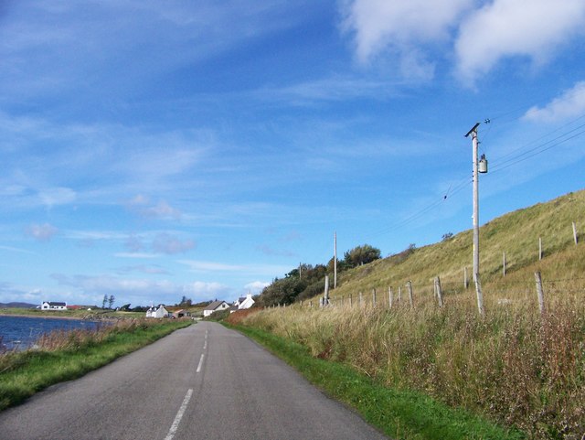
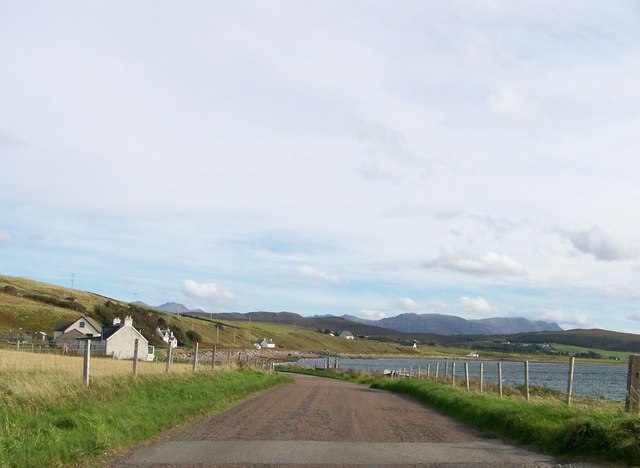
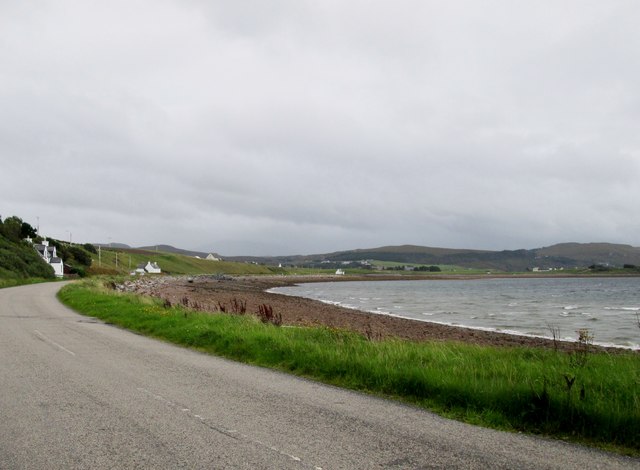
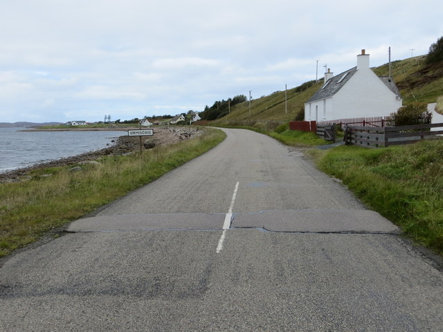
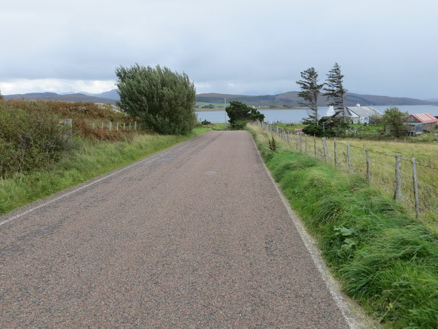
An Fhaodhailinn, located in Ross-shire, is a breathtaking beach that offers visitors a unique and tranquil experience. Situated along the picturesque coastline of the Scottish Highlands, this secluded beach offers stunning views of the surrounding landscape.

An Fhaodhailinn is known for its pristine white sands, which stretch for approximately half a mile, providing ample space for visitors to relax and soak up the sunshine. The crystal-clear waters of the beach are perfect for swimming, and the absence of crowds ensures a peaceful and serene atmosphere.

The beach is surrounded by rugged cliffs and lush vegetation, creating a sense of seclusion and natural beauty. It is also home to a diverse range of wildlife, including various bird species and marine life, making it an ideal spot for nature enthusiasts.

Visitors can enjoy long walks along the coast, exploring the tidal pools and rock formations that dot the shoreline. The beach is also a popular spot for picnics, as there are numerous grassy areas and benches available for visitors to enjoy a meal while taking in the stunning views.

An Fhaodhailinn is easily accessible by car, with parking available nearby. However, it is important to note that there are no facilities or amenities directly on the beach, so visitors should come prepared with food, water, and any other necessities they may require.

Overall, An Fhaodhailinn is a hidden gem that offers a peaceful and picturesque escape from the bustling city life. Its natural beauty and serene ambiance make it a must-visit destination for those seeking tranquility and a connection with nature.

If you have any feedback on the listing, please let us know in the comments section below.

An Fhaodhailinn Images

Images are sourced within 2km of 57.840153/-5.5909361 or Grid Reference NG8689. Thanks to Geograph Open Source API. All images are credited.

Shore road near Ormiscaig
Leaving Ormiscaig heading to Aultbea
Road  following  loch  side  toward  Aultbea
Road following loch side toward Aultbea
Road beside Loch Ewe entering Ormiscaig Looking north-westward.
Road beside Loch Ewe entering Ormiscaig
Looking north-westward.
Road near Ormiscaig Looking south-eastward.
Road near Ormiscaig
Looking south-eastward.
Coastline by Bualnaluib Small coastal crofting community.
Coastline by Bualnaluib
Small coastal crofting community.
Sea shore near Ormiscaig With some of the houses of Ormiscaig beyond.
Sea shore near Ormiscaig
With some of the houses of Ormiscaig beyond.
Ormiscaig houses
Ormiscaig houses
Loch Ewe viewpoint The information board describes the importance of Loch Ewe as a base for the Arctic convoys that supplied Russia during WW2. Merchant ships and their Naval escorts would assemble in the loch before the hazardous voyage north. 

The loch is still used a NATO ship refuelling point at the pier below. The Isle of Ewe is in the background.
Loch Ewe viewpoint
The information board describes the importance of Loch Ewe as a base for the Arctic convoys that supplied Russia during WW2. Merchant ships and their Naval escorts would assemble in the loch before the hazardous voyage north. The loch is still used a NATO ship refuelling point at the pier below. The Isle of Ewe is in the background.
Ship at the fuelling jetty, Loch Ewe A ship at the NATO refuelling jetty with the Isle of Ewe beyond.
Ship at the fuelling jetty, Loch Ewe
A ship at the NATO refuelling jetty with the Isle of Ewe beyond.
Russian Arctic Convoy Exhibition, Aultbea A comprehensive collection of photographs, memorabilia and artefacts from the WW2 supply convoys that assembled in Loch Ewe prior to their journey to northern Russian ports. See also <a href="https://www.geograph.org.uk/photo/6960054">NG8787 : Loch Ewe viewpoint</a>.
Russian Arctic Convoy Exhibition, Aultbea
A comprehensive collection of photographs, memorabilia and artefacts from the WW2 supply convoys that assembled in Loch Ewe prior to their journey to northern Russian ports. See also NG8787 : Loch Ewe viewpoint.
Aultbea and Loch Ewe
Aultbea foreshore The cream-coloured building on the left is the Aultbea Hall, now closed.
Aultbea foreshore
The cream-coloured building on the left is the Aultbea Hall, now closed.
Aultbea Stores Well-stocked village shop on the shores of Loch Ewe.
Aultbea Stores
Well-stocked village shop on the shores of Loch Ewe.
Coastal road at Aultbea The road connects Mellon Charles with Aultbea and the A832.
Coastal road at Aultbea
The road connects Mellon Charles with Aultbea and the A832.
Pier at Aird Point, Aultbea
Aultbea Hall A former community hall - we were told locally that the building was now unserviceable and that plans were in hand to use a church hall at the south end of the village.
Aultbea Hall
A former community hall - we were told locally that the building was now unserviceable and that plans were in hand to use a church hall at the south end of the village.
Refuelling jetty, Loch Ewe Seen from the shore at Aultbea.
Refuelling jetty, Loch Ewe
Seen from the shore at Aultbea.
Show me another place!

An Fhaodhailinn is located at Grid Ref: NG8689 (Lat: 57.840153, Lng: -5.5909361)

Unitary Authority: Highland

Police Authority: Highlands and Islands

What 3 Words

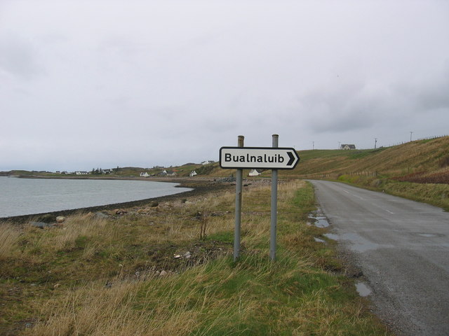
///zoomed.submitted.entry. Near Gairloch, Highland

Related Wikis

Aultbea

Aultbea (Gaelic: An t-Allt Beithe) is a small coastal fishing village in the North-West Highlands of Scotland. It is situated on the southeast shore of...

Loch Ewe distillery

Loch Ewe distillery in Drumchork near Aultbea in the Scottish Highlands was the smallest legally operated distillery in Scotland. It was set up in 2005...

Loch Ewe

Loch Ewe (Scottish Gaelic: Loch Iùbh) is a sea loch in the region of Wester Ross in the Northwest Highlands of Scotland. The shores are inhabited by a...

Isle of Ewe

The Isle of Ewe (Scottish Gaelic: Eilean Iùbh) is a small Scottish island on the west coast of Ross and Cromarty. The island is inhabited by a single family...

Nearby Amenities

Located within 500m of 57.840153,-5.5909361
Source: PGS
Lat/Long: 57.840682/-5.5991168
Source: PGS
Lat/Long: 57.8406279/-5.5988164
Source: PGS
Lat/Long: 57.8403624/-5.598233
Source: PGS
Lat/Long: 57.8401012/-5.5975769
Source: PGS
Lat/Long: 57.8398766/-5.597311
Source: PGS
Lat/Long: 57.8393513/-5.5970578
Source: PGS
Lat/Long: 57.8391622/-5.5971633
Source: PGS
Lat/Long: 57.8390596/-5.5967933
Source: PGS
Lat/Long: 57.8387431/-5.5965695
Source: PGS
Lat/Long: 57.8384074/-5.5962527
Source: PGS
Lat/Long: 57.8381965/-5.595845
Source: PGS
Lat/Long: 57.8381561/-5.5953026
Source: PGS
Lat/Long: 57.8382266/-5.5948659
Source: PGS
Lat/Long: 57.8382412/-5.5932534
Source: PGS
Lat/Long: 57.8393893/-5.5943576
Source: PGS
Lat/Long: 57.8398164/-5.5951651
Source: PGS
Lat/Long: 57.8400614/-5.5952758
Source: PGS
Lat/Long: 57.8410084/-5.5954266
Source: PGS
Lat/Long: 57.8413817/-5.5943067
Source: PGS
Lat/Long: 57.8414261/-5.5937922
Source: PGS
Lat/Long: 57.8413028/-5.592136
Source: PGS
Lat/Long: 57.8409786/-5.5893618
Source: PGS
Lat/Long: 57.8406922/-5.5883411
Source: PGS
Lat/Long: 57.8404676/-5.5873338
Source: PGS
Lat/Long: 57.840255/-5.5863927
Source: PGS
Lat/Long: 57.839936/-5.5855355
Source: PGS
Lat/Long: 57.8395831/-5.5849263
Source: PGS
Lat/Long: 57.8395939/-5.584604
Source: PGS
Lat/Long: 57.8397275/-5.5842787
Source: PGS
Lat/Long: 57.839711/-5.5838057
Source: PGS
Lat/Long: 57.8396647/-5.5837975
Source: PGS
Lat/Long: 57.8396369/-5.5838572
Source: PGS
Lat/Long: 57.8395162/-5.5846103
Source: PGS
Lat/Long: 57.8387372/-5.5845563
Source: PGS
Lat/Long: 57.8386086/-5.5845066
Source: PGS
Lat/Long: 57.8383906/-5.5840533
Bus Stop
Bus Shelter
Local Ref: AT
Naptan AtcoCode: 6700712386
Naptan Bearing: SE
Naptan CommonName: Bus Shelter
Naptan Indicator: at
Naptan Landmark: Telephone Box
Naptan NaptanCode: 45325268
Naptan Street: Pier Road
Naptan Verified: no
Source: naptan_import
Lat/Long: 57.8408784/-5.5955711
Post Office
Source: OS_OpenData_StreetView
Lat/Long: 57.8404352/-5.585809
Seamark Light Category: vertical
Seamark Light Character: F
Seamark Light Colour: green
Seamark Light Height: 8
Seamark Light Multiple: 2
Seamark Light Range: 3
Seamark Light Reference: A 3887.5
Seamark Type: light_minor
Source: US NGA Pub. 114. 2011-05-26.
Lat/Long: 57.8382167/-5.5934167
Aultbea
Name En: Aultbea
Name Gd: An t-Allt Beithe
Place: village
Wikidata: Q772427
Wikipedia: en:Aultbea
Lat/Long: 57.8406849/-5.5836719
Aultbea Hotel
Email: aultbeahotel@btconnect.com
Phone: +44 1445 731201
Tourism: hotel
Website: https://www.aultbeahotel.co.uk/
Lat/Long: 57.8389977/-5.5842937
Leisure: slipway
Lat/Long: 57.8391449/-5.5974062
Parking
Parking: surface
Lat/Long: 57.8391812/-5.5958216
Toilets
Fee: no
Source: OpenStreetBugs
Wheelchair: no
Lat/Long: 57.8393059/-5.5837486
Telephone
Booth: K6
Covered: booth
Phone: +44 1445 731255
Source: survey
Lat/Long: 57.8408323/-5.5959084
Post Box
Operator: Royal Mail
Operator Wikidata: Q638098
Post Box Mounting: building
Post Box Type: wall
Ref: IV22 213
Source: survey
Lat/Long: 57.8404594/-5.5859859
Aultbea Stores
Opening Hours: Mo-Sa 09:00-17:00
Shop: convenience
Lat/Long: 57.8417454/-5.5935538
Power: pole
Lat/Long: 57.8407387/-5.5843681
Power: pole
Lat/Long: 57.841101/-5.5853216
Power: pole
Lat/Long: 57.841459/-5.5862862
Power: pole
Lat/Long: 57.8418037/-5.5871819
Power: pole
Lat/Long: 57.8421895/-5.5882595
Power: pole
Lat/Long: 57.8426492/-5.5894879
Power: pole
Lat/Long: 57.8422775/-5.5929006
Power: pole
Lat/Long: 57.8421843/-5.5923949
Power: pole
Lat/Long: 57.8420861/-5.5918561
Power: pole
Lat/Long: 57.8418022/-5.5902714
Power: pole
Lat/Long: 57.8415426/-5.5889526
Power: pole
Lat/Long: 57.8413071/-5.5882113
Power: pole
Lat/Long: 57.840669/-5.5861898
Power: pole
Lat/Long: 57.8404343/-5.5854801
Power: pole
Lat/Long: 57.8401915/-5.5847553
Power: pole
Lat/Long: 57.8399311/-5.583996
Power: pole
Lat/Long: 57.8397624/-5.5835151
Power: pole
Lat/Long: 57.8413079/-5.5965219
Power: pole
Lat/Long: 57.8414604/-5.596278
Power: pole
Lat/Long: 57.8416651/-5.5960093
Power: pole
Lat/Long: 57.8423259/-5.5951343
Power: pole
Lat/Long: 57.8424491/-5.594962
Power: pole
Lat/Long: 57.8443358/-5.5928875
Power: pole
Lat/Long: 57.8437227/-5.5920607
Power: pole
Lat/Long: 57.8428427/-5.5900898
Power: pole
Lat/Long: 57.8428774/-5.5939809
Power: pole
Lat/Long: 57.8432991/-5.5930158
Power: pole
Lat/Long: 57.8423612/-5.5940314
Power: pole
Lat/Long: 57.839308/-5.5834081
Power: pole
Lat/Long: 57.8431542/-5.590913
Power: pole
Lat/Long: 57.8434266/-5.5916172
Power: pole
Lat/Long: 57.842931/-5.5914292
Power: pole
Lat/Long: 57.8434151/-5.5902933
Power: pole
Lat/Long: 57.8436777/-5.5896848
Power: pole
Lat/Long: 57.8439068/-5.5891679
Power: pole
Lat/Long: 57.8441638/-5.5886065
Àird Point
Natural: cape
Lat/Long: 57.8385909/-5.5953736
Alex Forbes & Son
Addr Street: Aultbea
Description: Garage
Opening Hours: Mo-Fr 08:00-17:00
Phone: +441445731200
Shop: car_repair
Lat/Long: 57.8403566/-5.5825052
Recycling
Recycling Type: container
Lat/Long: 57.839788/-5.5841808
The data included in this document is from www.openstreetmap.org. The data is made available under ODbL.

Have you been to An Fhaodhailinn?

Leave your review of An Fhaodhailinn below (or comments, questions and feedback).