Tràigh an Luig
Beach in Argyllshire
Scotland
Tràigh an Luig
![Standing Stone "A standing stone, 3m high and 1.4m by 0.6m at base, with approximately vertical sides and a gabled top. It is aligned north-south."
From Canmore.org.uk. Islay, Uiskentuie | Canmore. Available online at: <span class="nowrap"><a title="https://canmore.org.uk/site/37426/islay-uiskentuie" rel="nofollow ugc noopener" href="https://canmore.org.uk/site/37426/islay-uiskentuie">Link</a><img style="margin-left:2px;" alt="External link" title="External link - shift click to open in new window" src="https://s1.geograph.org.uk/img/external.png" width="10" height="10"/></span> [Accessed 29 May 2022].](https://s1.geograph.org.uk/geophotos/07/18/54/7185469_f59a87da.jpg)
Tràigh an Luig, situated in Argyllshire, Scotland, is a mesmerizing beach that offers visitors a serene and picturesque coastal experience. Nestled along the western coast of Scotland, this beach is known for its stunning natural beauty and tranquil atmosphere.
The beach stretches over a mile long and is characterized by its golden sandy shores and crystal-clear turquoise waters. Its remote location provides a sense of seclusion and peace, making it a perfect destination for those seeking tranquility and relaxation. The surrounding landscape is adorned with lush greenery and rugged cliffs, creating a breathtaking vista that showcases the raw beauty of the Scottish coastline.
Tràigh an Luig is also home to a diverse array of wildlife, including various seabirds and marine life. Visitors often have the opportunity to spot dolphins, seals, and even basking sharks in the surrounding waters. Nature enthusiasts and birdwatchers will be delighted by the abundance of wildlife that calls this beach their home.
Due to its remote location, the beach remains relatively untouched by commercial development, providing a sense of natural purity. Visitors can take leisurely walks along the shore, breathe in the fresh sea air, and enjoy stunning sunsets over the water.
While Tràigh an Luig may not have the typical amenities found at more popular tourist destinations, its natural charm and unspoiled beauty make it a hidden gem worth exploring. Whether you are seeking solitude, a scenic coastal experience, or a chance to connect with nature, Tràigh an Luig offers a truly unforgettable beach experience in Argyllshire, Scotland.
If you have any feedback on the listing, please let us know in the comments section below.
Tràigh an Luig Images
Images are sourced within 2km of 55.784086/-6.3449737 or Grid Reference NR2763. Thanks to Geograph Open Source API. All images are credited.


Tràigh an Luig is located at Grid Ref: NR2763 (Lat: 55.784086, Lng: -6.3449737)
Unitary Authority: Argyll and Bute
Police Authority: Argyll and West Dunbartonshire
What 3 Words
///motivator.tradition.folk. Near Bowmore, Argyll & Bute
Nearby Locations
Related Wikis
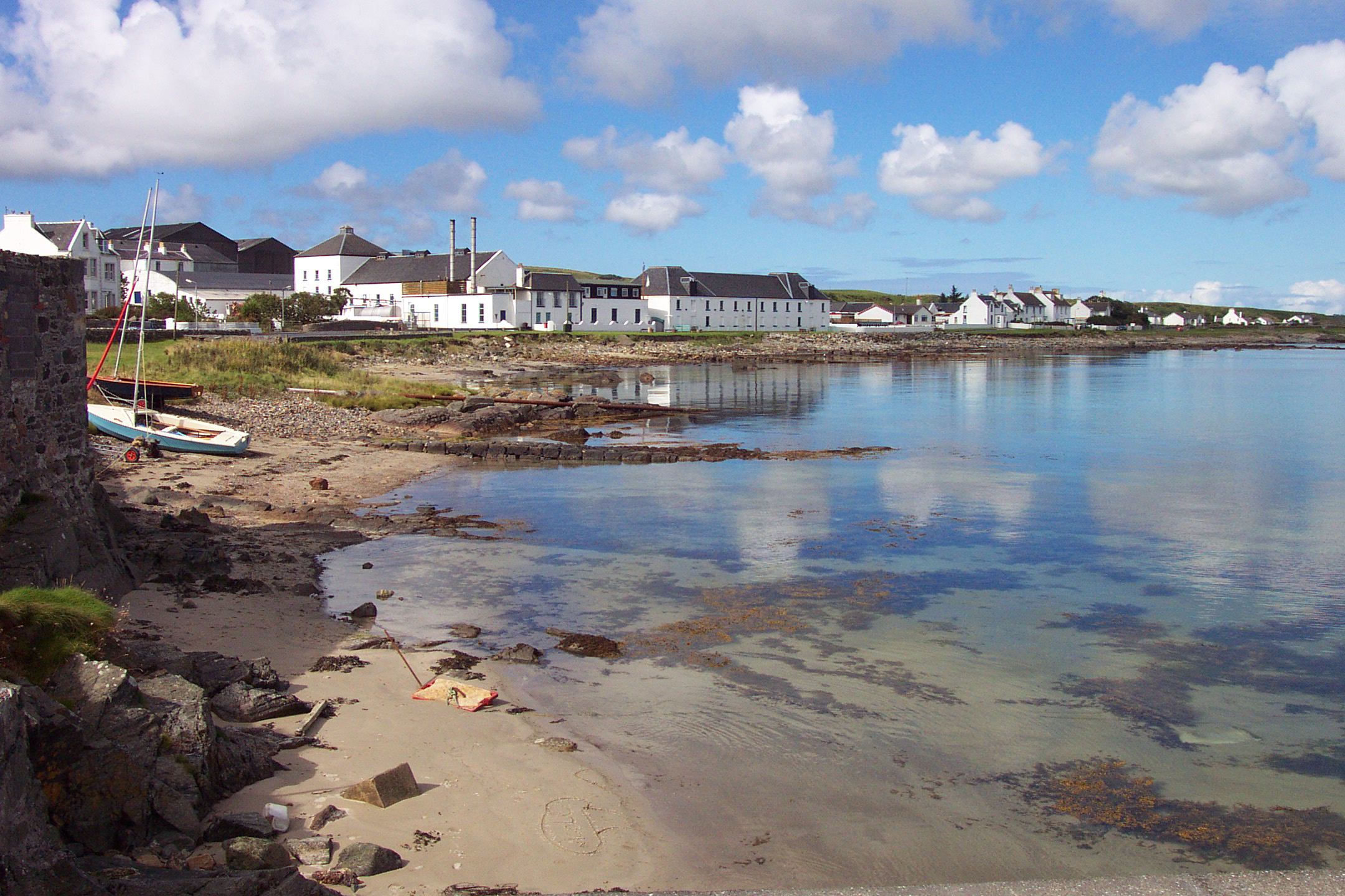
Bruichladdich distillery
Bruichladdich distillery ( bruukh-LAD-ee; Scottish Gaelic: [pɾuə'xl̪ˠat̪ɪç]) is a distillery on the Rhinns of the isle of Islay in Scotland. The distillery...
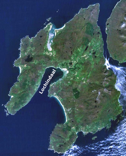
Loch Indaal
Loch Indaal (or Lochindaal) is a sea loch on Islay, the southernmost island of the Hebrides, off the west coast of Scotland. Together with Loch Gruinart...

Gruinart Flats
The Gruinart Flats is a low-lying landform on the western part of the isle of Islay in Scotland. The locale is an important conservation area, having been...

Battle of Traigh Ghruinneart
The Battle of Traigh Ghruinneart or in Scottish Gaelic Blàr Tràigh Ghruineart or sometimes called the Battle of Gruinart Strand was a Scottish clan battle...

A847 road
The A847 road is one of the two principal roads of Islay in the Inner Hebrides off the west coast of mainland Scotland. It connects Bridgend, at a junction...

Bowmore distillery
Bowmore distillery ( boh-MOR, Scottish Gaelic: Taigh-staile Bogh Mòr) produces Scotch whisky on the Isle of Islay, an island of the Inner Hebrides.The...

RAF Bowmore
Royal Air Force Bowmore or more simply RAF Bowmore is a former Royal Air Force seaplane station located in Bowmore, Argyll and Bute, Scotland. The following...
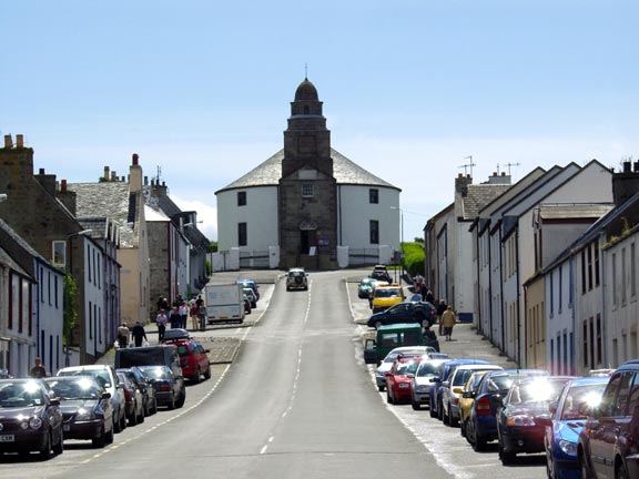
Bowmore
Bowmore (Scottish Gaelic: Bogh Mòr, 'Big Bend') is a small town on the Scottish island of Islay. It serves as administrative capital of the island, and...
Related Videos
Walking the Loch Indaal Way coastal path on the Rhinns of Islay
A walk from Port Charlotte to Bruichladdich on the Loch Indaal Way coastal path on the Rhinns of Islay on a beautiful sunny late ...

Menghadiri acara Festival Bruichladdich || Desa Kecil di Skotlandia #shorts
MENGHADIRI ACARA FESTIVAL DI BRUICHLADDICH DESA KECIL DI SKOTLANDIA #shorts tag festival viral , festival shorts ...

Isle of islay,in lockdown
Stay safe.

The Reid clan visit Islay and stay in Bruichladdich with a tour to of the whiskey & gin distillery.
This is a short video of our trip to Islay in 2018, this was Davids and the kids first trip there and certainly won't be our last, did the ...
Nearby Amenities
Located within 500m of 55.784086,-6.3449737Have you been to Tràigh an Luig?
Leave your review of Tràigh an Luig below (or comments, questions and feedback).