Swansea Bay

Bay in Glamorgan

Wales

Swansea Bay

Looking South from the North end of Rest Bay Very flat grassy banks mark the end of Rest Bay. In the distance is the golf course and the large building is The Rest.
Looking South from the North end of Rest Bay Credit: Trevor Rickard

Swansea Bay, located in Glamorgan, Wales, is a picturesque and historically significant bay renowned for its natural beauty and cultural heritage. Stretching for about 10 miles along the south coast of Wales, it is a popular destination for locals and tourists alike.

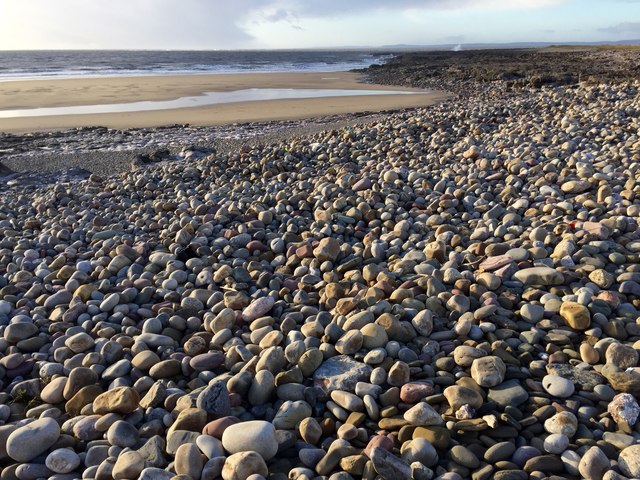
The bay is characterized by its stunning sandy beaches, including the famous Swansea Beach, which offers a perfect spot for sunbathing, swimming, and other water activities. The bay's tidal range is the second highest in the world, reaching up to 8 meters during spring tides, making it a hotspot for water sports enthusiasts, particularly windsurfers and kiteboarders.

Swansea Bay also boasts a wealth of historical attractions. The Mumbles, a charming seaside village at the western end of the bay, is home to the iconic Mumbles Pier, a Victorian structure that offers breathtaking views of the bay. Further east, visitors can explore the ruins of Oystermouth Castle, a medieval stronghold with a rich history.

In addition to its natural and historical attractions, Swansea Bay hosts a range of events and activities throughout the year. The annual Swansea Bay Summer Festival, held on the beachfront, features live music, food stalls, and a vibrant carnival atmosphere. The bay is also a hub for sailing races and hosts the Swansea Bay Yacht Race, attracting sailors from around the world.

Overall, Swansea Bay is a captivating destination that offers a perfect mix of natural beauty, cultural heritage, and recreational activities for visitors of all interests.

If you have any feedback on the listing, please let us know in the comments section below.

Swansea Bay Images

Images are sourced within 2km of 51.505729/-3.7468189 or Grid Reference SS7879. Thanks to Geograph Open Source API. All images are credited.

Looking South from the North end of Rest Bay Very flat grassy banks mark the end of Rest Bay. In the distance is the golf course and the large building is The Rest.
Looking South from the North end of Rest Bay
Very flat grassy banks mark the end of Rest Bay. In the distance is the golf course and the large building is The Rest.
Sker Point and Kenfig Sands Practically at sea level, Sker Point is just a grassy knoll. The vast expanse of Kenfig Sands is in the middle distance leading to Margam Sands and the Port Talbot steel works. The hills at the back mark the coastline of Swansea Bay.
Sker Point and Kenfig Sands
Practically at sea level, Sker Point is just a grassy knoll. The vast expanse of Kenfig Sands is in the middle distance leading to Margam Sands and the Port Talbot steel works. The hills at the back mark the coastline of Swansea Bay.
Sker House Atop the wind blasted dunes of Sker Point, a Cistercian monastery founded some 900 years ago became a private house in Tudor times. It has had a chequered history and is surrounded by impossibly romantic tales of ghosts and thwarted love.  This picture was taken just a very few years before the house, derelict for a century, was saved from total collapse and is now saved for the nation as one of the most important historic houses in Wales.
Sker House
Atop the wind blasted dunes of Sker Point, a Cistercian monastery founded some 900 years ago became a private house in Tudor times. It has had a chequered history and is surrounded by impossibly romantic tales of ghosts and thwarted love. This picture was taken just a very few years before the house, derelict for a century, was saved from total collapse and is now saved for the nation as one of the most important historic houses in Wales.
Sker Rocks Looking southwards over Sker Rocks from a position just above the western end of the beach at Sker Point. Visible in the photograph is the inlet Pwll Dafan which runs deep into the mass of rock.
Sker Rocks
Looking southwards over Sker Rocks from a position just above the western end of the beach at Sker Point. Visible in the photograph is the inlet Pwll Dafan which runs deep into the mass of rock.
The beach at Sker Point Looking roughly south east along the beach at Sker Point. A good deal of the beach further away from the camera lies outside the grid square.
The beach at Sker Point
Looking roughly south east along the beach at Sker Point. A good deal of the beach further away from the camera lies outside the grid square.
Rest Bay coastline Looking north-west towards the expanse of the flat Ffynnon-wen Rocks.
Sker Point is in the distance.
Rest Bay coastline
Looking north-west towards the expanse of the flat Ffynnon-wen Rocks. Sker Point is in the distance.
Morning walk on the beach The showery weather has not put off this man and his dog from their stroll along the beach at Rest Bay.
The weather did not put the photographer off either!
Morning walk on the beach
The showery weather has not put off this man and his dog from their stroll along the beach at Rest Bay. The weather did not put the photographer off either!
Pwll Dafan The name of the inlet into the platform of rocks at Sker Point.
Looking west from the coast path.
Pwll Dafan
The name of the inlet into the platform of rocks at Sker Point. Looking west from the coast path.
Golf course maintenance Royal Porthcawl Golf Club operatives are working on the greens and tees to get the grass in good shape to go through the winter.
Golf course maintenance
Royal Porthcawl Golf Club operatives are working on the greens and tees to get the grass in good shape to go through the winter.
Trychineb Santampa 1947 / Santampa Disaster 1947 Mae Cofeb Trychineb Santampa yn coffau'r llong 7,219 tunell a ddrylliwyd ar Greigiau Sker yn ystod storm fawr ar 23ain Ebrill 1947 gan ladd 39 o'r criw oedd arni. Cofir hefyd am yr wyth aelod dewr o fad achub y Mwmbwls 'Edward Prince of Wales' a foddwyd pan suddodd y bad yn yr ymdrech i'w hachub. 

The Santampa Disaster Memorial commemorates the 7,219 ton ship which was shipwrecked on Sker Rocks during a terrible storm on 23 April 1947 killing all 39 crew members aboard. The memorial also remembers the eight gallant crew members of the Mumbles lifeboat 'Edward Prince of Wales' who were tragically drowned when their boat capsized at the scene while attempting the rescue.
Trychineb Santampa 1947 / Santampa Disaster 1947
Mae Cofeb Trychineb Santampa yn coffau'r llong 7,219 tunell a ddrylliwyd ar Greigiau Sker yn ystod storm fawr ar 23ain Ebrill 1947 gan ladd 39 o'r criw oedd arni. Cofir hefyd am yr wyth aelod dewr o fad achub y Mwmbwls 'Edward Prince of Wales' a foddwyd pan suddodd y bad yn yr ymdrech i'w hachub. The Santampa Disaster Memorial commemorates the 7,219 ton ship which was shipwrecked on Sker Rocks during a terrible storm on 23 April 1947 killing all 39 crew members aboard. The memorial also remembers the eight gallant crew members of the Mumbles lifeboat 'Edward Prince of Wales' who were tragically drowned when their boat capsized at the scene while attempting the rescue.
Wales Coast Path Boardwalk alongside Royal Porthcawl Golf Club.
Wales Coast Path
Boardwalk alongside Royal Porthcawl Golf Club.
Ffynnon Wen rocks Rocky shore at Ffynnon Wen.  Mumbles Head faintly visible on the horizon.
Ffynnon Wen rocks
Rocky shore at Ffynnon Wen. Mumbles Head faintly visible on the horizon.
Driftwood Sea washed tree trunk on the beach at Ffynnon Wen near Rest Bay, Porthcawl.
Driftwood
Sea washed tree trunk on the beach at Ffynnon Wen near Rest Bay, Porthcawl.
Cast ashore Old fishing net cast ashore near Rest Bay Porthcawl.
Cast ashore
Old fishing net cast ashore near Rest Bay Porthcawl.
Pebble beach The pink colour of the rocks and pebbles on this beach give rise to the name, Pink Bay.
Pebble beach
The pink colour of the rocks and pebbles on this beach give rise to the name, Pink Bay.
Storm Clouds Storm clouds gathering across the Bristol Channel.
Storm Clouds
Storm clouds gathering across the Bristol Channel.
Marram grass The flattened marram grass testifies to the prevailing winds which blow up the Bristol Channel.
Marram grass
The flattened marram grass testifies to the prevailing winds which blow up the Bristol Channel.
Coastal erosion With no marram grass to bind the sand, winds and tides continue to take their toll on this section of coastline.
Coastal erosion
With no marram grass to bind the sand, winds and tides continue to take their toll on this section of coastline.
Show me another place!

Swansea Bay is located at Grid Ref: SS7879 (Lat: 51.505729, Lng: -3.7468189)

Unitary Authority: Bridgend

Police Authority: South Wales

Also known as: Bae Abertawe

What 3 Words

///beaten.fastening.delighted. Near Pyle, Bridgend

Related Wikis

Mumbles lifeboat disaster

The Mumbles lifeboat disaster occurred in 1947 off south Wales when the Mumbles lifeboat was undertaking a rescue off Sker Point but was overwhelmed by...
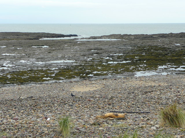
Sker Point

Sker Point is a headland in Bridgend County Borough on the South Wales coast between Port Talbot and Porthcawl. It marks the south end of Kenfig Sands...
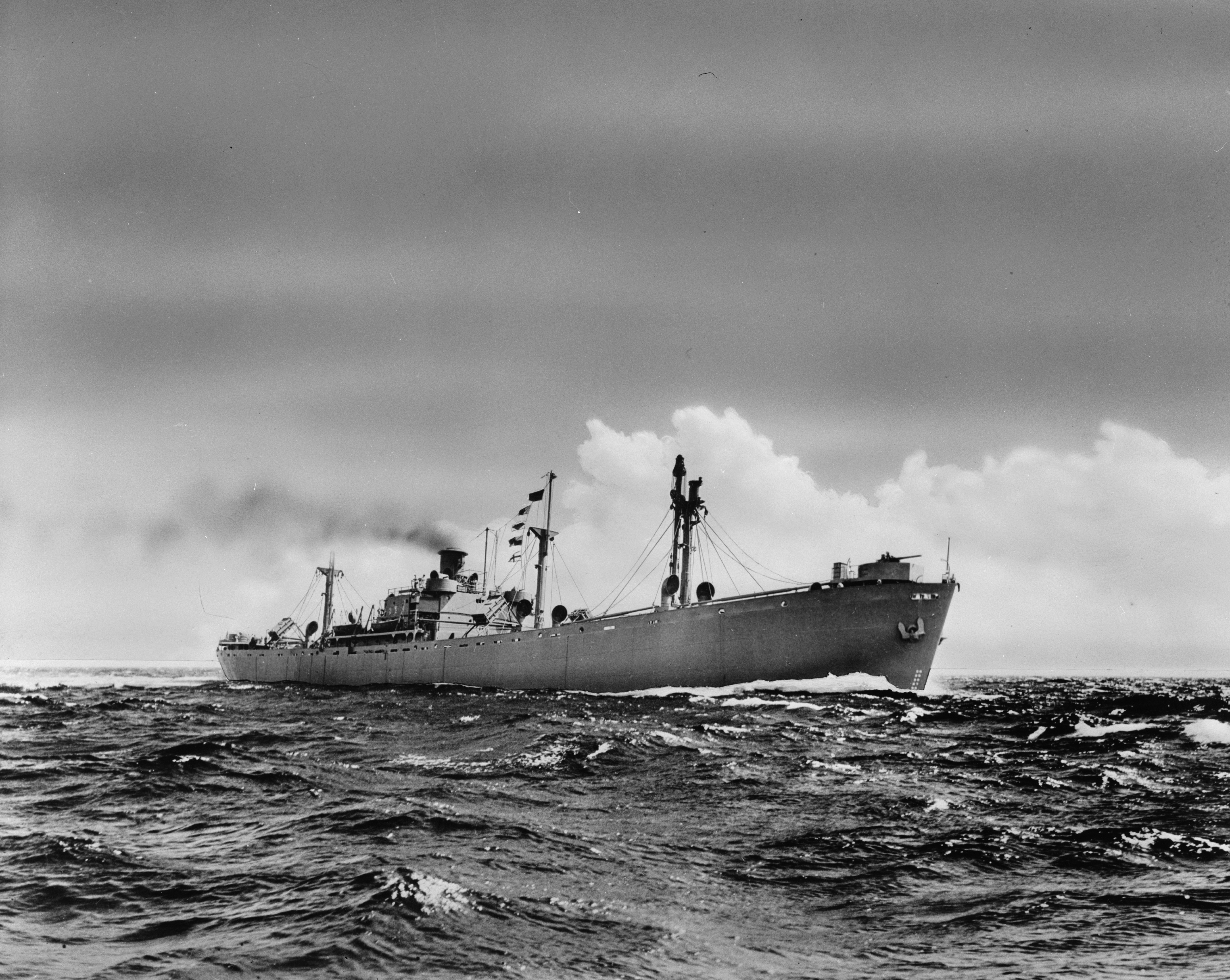
SS Samtampa

SS Samtampa was a 7,219 ton steamship wrecked on Sker Point, off Porthcawl and Kenfig, Wales, in the Bristol Channel on 23 April 1947. At the time of the...

Kenfig Pool

Kenfig Pool (Welsh: Pwll Cynffig) is a national nature reserve situated near Porthcawl, Bridgend. Wild storms and huge tides between the 13th and 15th...

Nearby Amenities

Located within 500m of 51.505729,-3.7468189
Source: PGS
Lat/Long: 51.5101269/-3.7481346
Source: PGS
Lat/Long: 51.5095434/-3.7476237
Source: PGS
Lat/Long: 51.5091475/-3.7471663
Source: PGS
Lat/Long: 51.5088134/-3.7468164
Source: PGS
Lat/Long: 51.508196/-3.7463066
Source: PGS
Lat/Long: 51.5078542/-3.7458699
Source: PGS
Lat/Long: 51.5074416/-3.7455344
Source: PGS
Lat/Long: 51.5072029/-3.7456724
Source: PGS
Lat/Long: 51.5068691/-3.745921
Source: PGS
Lat/Long: 51.5062095/-3.7467583
Source: PGS
Lat/Long: 51.5060385/-3.7470592
Source: PGS
Lat/Long: 51.504931/-3.7491786
Source: PGS
Lat/Long: 51.5044668/-3.7497019
Source: PGS
Lat/Long: 51.5037148/-3.749392
Source: PGS
Lat/Long: 51.5033547/-3.7490321
Source: PGS
Lat/Long: 51.5032941/-3.7487861
Source: PGS
Lat/Long: 51.50338/-3.7482427
Source: PGS
Lat/Long: 51.5035438/-3.7480299
Source: PGS
Lat/Long: 51.5038561/-3.7472031
Source: PGS
Lat/Long: 51.5038354/-3.746663
Source: PGS
Lat/Long: 51.5037522/-3.745095
Source: PGS
Lat/Long: 51.5032379/-3.7442304
Source: PGS
Lat/Long: 51.502827/-3.7438941
Source: PGS
Lat/Long: 51.5025305/-3.743825
Source: PGS
Lat/Long: 51.5021536/-3.7438051
Source: PGS
Lat/Long: 51.5058349/-3.7474255
Source: PGS
Lat/Long: 51.5055987/-3.7479096
The data included in this document is from www.openstreetmap.org. The data is made available under ODbL.

Have you been to Swansea Bay?

Leave your review of Swansea Bay below (or comments, questions and feedback).