Bight of Stavaness

Bay in Shetland

Scotland

Bight of Stavaness

The Groot, Stavaness Looking West towards The Groot from the sea loch of Stavaness, Nesting
The Groot, Stavaness Credit: Jeremy Duncan

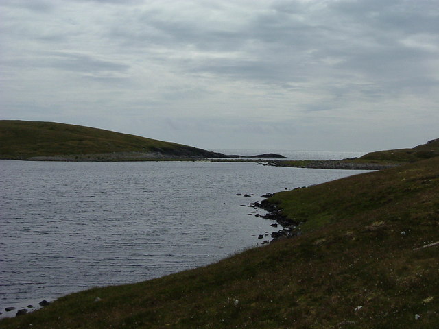
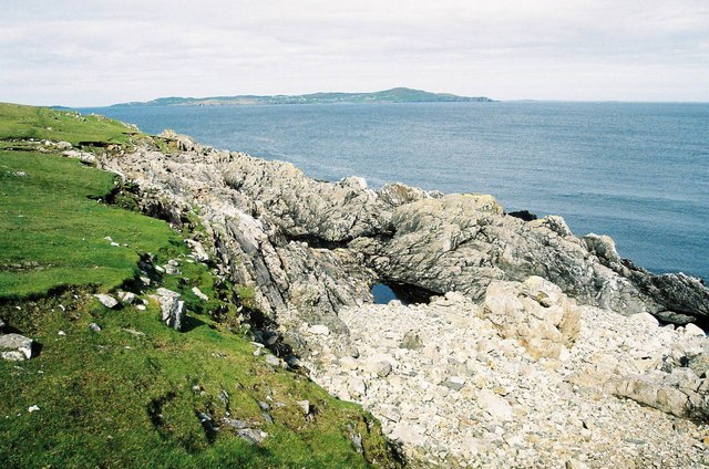
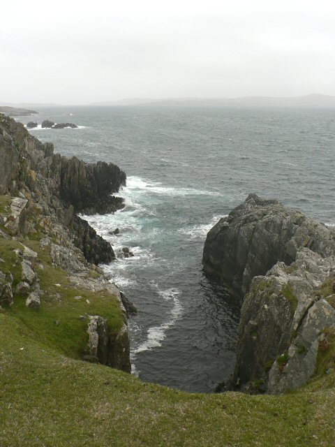
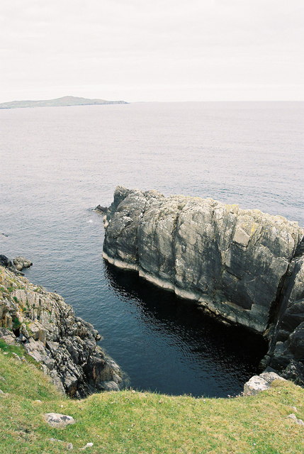
The Bight of Stavaness is a picturesque bay located in the Shetland Islands, Scotland. Positioned on the western coast of the mainland, it is renowned for its stunning natural beauty and tranquil atmosphere. The bay stretches approximately 2 kilometers in length and is enclosed by rugged cliffs and rolling hills, providing a sheltered and peaceful environment.

The Bight of Stavaness offers panoramic views of the North Atlantic Ocean, with its crystal-clear waters reflecting the vibrant hues of the surrounding landscape. The bay is home to a diverse array of marine life, including seals, otters, and various species of seabirds, making it a popular spot for wildlife enthusiasts and birdwatchers.

The surrounding area of the bay is characterized by lush green meadows and heather-covered moorland, creating a striking contrast against the deep blue waters. Visitors can explore the nearby coastal paths, which offer breathtaking vistas and opportunities for hiking and nature photography.

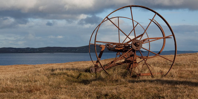
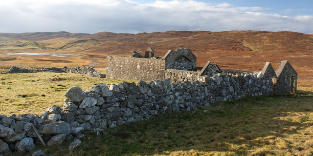
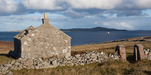
In addition to its natural splendor, the Bight of Stavaness holds historical significance. The bay was once a bustling harbor, serving as a crucial hub for fishing and trade in the region. Remnants of the past can still be seen, such as the ruins of old piers and fisherman cottages, providing a glimpse into the area's maritime heritage.

Overall, the Bight of Stavaness is a captivating destination that showcases the rugged beauty of the Shetland Islands. With its picturesque views, diverse wildlife, and rich history, it offers visitors a truly memorable and immersive experience.

If you have any feedback on the listing, please let us know in the comments section below.

Bight of Stavaness Images

Images are sourced within 2km of 60.324699/-1.1011576 or Grid Reference HU4960. Thanks to Geograph Open Source API. All images are credited.

The Groot, Stavaness Looking West towards The Groot from the sea loch of Stavaness, Nesting
The Groot, Stavaness
Looking West towards The Groot from the sea loch of Stavaness, Nesting
Coastline at Valla Ness, looking NE to Whalsay The foreground shows the rough pasture and coastline in this part of Mainland Shetland.
The island of Whalsay, which lies North East of Lerwick, can clearly be seen in the distance, around 5km from where the picture was taken.
Coastline at Valla Ness, looking NE to Whalsay
The foreground shows the rough pasture and coastline in this part of Mainland Shetland. The island of Whalsay, which lies North East of Lerwick, can clearly be seen in the distance, around 5km from where the picture was taken.
Seli Geo
Seli Geo
Calm sea at Seli Geo - with Whalsay on the horizon
Old Farm Machinery, Nesting, Shetland Islands Old farm machinery at Nesting near Neap, Kirkabister, Shetland Islands, with the island of Whalsay in the distance
Old Farm Machinery, Nesting, Shetland Islands
Old farm machinery at Nesting near Neap, Kirkabister, Shetland Islands, with the island of Whalsay in the distance
Ruined croft near Neap, Shetland Islands A ruined croft near Neap, Kirkabister, Shetland Islands
Ruined croft near Neap, Shetland Islands
A ruined croft near Neap, Kirkabister, Shetland Islands
Ruined crofthouse near Neap, Shetland Islands A ruined crofthouse near Neap, Nesting, Shetland Islands, with the island of Whalsay in the distance
Ruined crofthouse near Neap, Shetland Islands
A ruined crofthouse near Neap, Nesting, Shetland Islands, with the island of Whalsay in the distance
Coastal inlet Top of the coastal inlet
Coastal inlet
Top of the coastal inlet
The Vadill, Billister, at high tide Vadill means a place that can be waded across, but the tide is in.
The Vadill, Billister, at high tide
Vadill means a place that can be waded across, but the tide is in.
House between Billister and Laxfirth Overlooking the head of the Vadill.
House between Billister and Laxfirth
Overlooking the head of the Vadill.
Head of the Vadill, Billister The pink plant on the left is a garden escape, Sweet Rocket.
Head of the Vadill, Billister
The pink plant on the left is a garden escape, Sweet Rocket.
Quoys pier Pier at Quoys
Quoys pier
Pier at Quoys
Quoys pier A small piece of land by Quoys Pier.  There is a picnic bench and space to pull up several cars, making a useful wild camping spot.
Quoys pier
A small piece of land by Quoys Pier. There is a picnic bench and space to pull up several cars, making a useful wild camping spot.
Billister: the pier A tiny harbour on Lax Firth, an inlet from the much larger Dury Voe, which is in the background.
Billister: the pier
A tiny harbour on Lax Firth, an inlet from the much larger Dury Voe, which is in the background.
Billister: old Zetland County Council stone This small slab of stone is almost hidden in the long grass opposite the pier (see <a href="https://www.geograph.org.uk/photo/2758868">HU4760 : Billister: the pier</a>) and is inscribed with the Zetland County Council emblem with the name Billister Pier below.

Zetland County Council is the predecessor (1974) to the present-day Shetland Islands Council.
Billister: old Zetland County Council stone
This small slab of stone is almost hidden in the long grass opposite the pier (see HU4760 : Billister: the pier) and is inscribed with the Zetland County Council emblem with the name Billister Pier below. Zetland County Council is the predecessor (1974) to the present-day Shetland Islands Council.
Billister: the telephone box Looking down the lane towards Billister pier, with a red telephone box on the right. The box also acts as the repository for post for the wheelchair-bound lady, who lives in the cottage, as I discovered when I found a letter (visible on the shelf) inside the box. I knocked on the door and she cheerfully told me that her home help or other visitors checked the box before coming in.
Billister: the telephone box
Looking down the lane towards Billister pier, with a red telephone box on the right. The box also acts as the repository for post for the wheelchair-bound lady, who lives in the cottage, as I discovered when I found a letter (visible on the shelf) inside the box. I knocked on the door and she cheerfully told me that her home help or other visitors checked the box before coming in.
Billister, North Nesting Three houses of different ages, possibly even built in different centuries.
Billister, North Nesting
Three houses of different ages, possibly even built in different centuries.
Billister pier, North Nesting Formerly the route to Whalsay.
Billister pier, North Nesting
Formerly the route to Whalsay.
Show me another place!

Bight of Stavaness is located at Grid Ref: HU4960 (Lat: 60.324699, Lng: -1.1011576)

Unitary Authority: Shetland Islands

Police Authority: Highlands and Islands

What 3 Words

///mastering.bicker.midwinter. Near Symbister, Shetland Islands

Related Wikis

Billister

Billister is a settlement in the parish of Nesting, on the island of Mainland, in Shetland, Scotland. It is on Lax Firth. Billister was formerly the terminal...

Neap

Neap is a small village in the east coast of the Mainland of the Shetland Islands, Scotland. Neap is situated at the end of the road from Brettabister...

Nesting, Shetland

Nesting is a parish in the Shetland Islands, Scotland. It includes a part of the east Shetland Mainland, measuring about twelve by four miles (19 by 6...

Brettabister

Brettabister is a settlement on the island of Mainland in Shetland, Scotland. It is in the parish of Nesting. St. Ola's parish church lies to the east...

Holm of Sandwick

The Holm of Sandwick is an islet, located roughly 100 metres (330 ft) off Haa Ness and the southwestern side of Whalsay, in the Shetland Islands of Scotland...

Clate

Clate (also known as Clett) is a hamlet and ward in southwestern Whalsay in the parish of Nesting in the Shetland Islands of Scotland. == Geography... ==

Pier House Museum

The Pier House Museum is a museum in Symbister, Whalsay, in the Shetland Islands of Scotland. The museum is located in the old Pier House, which was once...

Sandwick, Whalsay

Sandwick is a hamlet, often considered part of the main village of Symbister along with adjacent Harlsdale, in the parish of Nesting in southwestern Whalsay...

Nearby Amenities

Located within 500m of 60.324699,-1.1011576
Bight of Stavaness
Natural: bay
Lat/Long: 60.3240583/-1.1028815
The data included in this document is from www.openstreetmap.org. The data is made available under ODbL.

Have you been to Bight of Stavaness?

Leave your review of Bight of Stavaness below (or comments, questions and feedback).