Starnakeppie
Bay in Aberdeenshire
Scotland
Starnakeppie

Starnakeppie Bay is a picturesque coastal region located in Aberdeenshire, Scotland. Nestled amidst the stunning natural beauty of the northeastern coastline, it offers visitors a tranquil retreat from the hustle and bustle of city life. The bay is known for its pristine sandy beaches, rugged cliffs, and crystal-clear waters.
Situated a short distance from the charming village of Collieston, Starnakeppie Bay is a popular destination for nature lovers and outdoor enthusiasts. The bay is encompassed by rolling hills and lush greenery, providing ample opportunities for hiking, walking, and exploring the surrounding countryside.
The beach at Starnakeppie Bay stretches for approximately one mile and is a haven for beachcombing, sunbathing, and picnicking. The peaceful atmosphere and breathtaking views make it an ideal spot for relaxation and unwinding. Visitors can also enjoy a variety of water sports, such as swimming, kayaking, and paddleboarding.
The wildlife in Starnakeppie Bay is diverse and abundant. Birdwatchers can spot a wide range of seabirds, including gannets, puffins, and guillemots. Dolphins and seals can often be seen swimming in the bay, adding to the area's natural charm.
The bay is easily accessible by car, with parking facilities available nearby. Facilities such as public toilets and picnic areas are also provided, ensuring visitors have a comfortable and enjoyable experience.
In summary, Starnakeppie Bay in Aberdeenshire is a breathtaking coastal region offering a serene and idyllic getaway. Whether you're seeking outdoor adventures, peaceful beach days, or wildlife encounters, this hidden gem has something for everyone.
If you have any feedback on the listing, please let us know in the comments section below.
Starnakeppie Images
Images are sourced within 2km of 57.612324/-1.8572876 or Grid Reference NK0858. Thanks to Geograph Open Source API. All images are credited.


Starnakeppie is located at Grid Ref: NK0858 (Lat: 57.612324, Lng: -1.8572876)
Unitary Authority: Aberdeenshire
Police Authority: North East
What 3 Words
///shine.ombudsman.skies. Near Peterhead, Aberdeenshire
Nearby Locations
Related Wikis
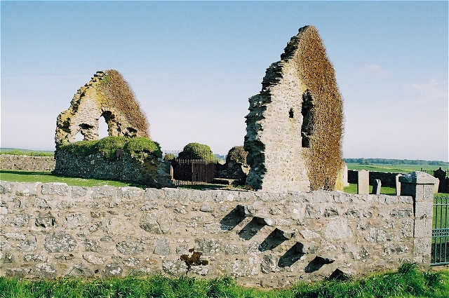
St Mary's Chapel, Rattray
St Mary's Chapel (known also as "the Chapel of the Blessed Virgin") is a late 12th/early 13th century chapel found in Rattray, Aberdeenshire, Scotland...

Castle of Rattray
The Castle of Rattray was a medieval Scottish castle, with multiple variations on its structure over approximately six centuries. Originally built as a...
Rattray, Aberdeenshire
Rattray (historic: Rettre; occasionally: Rattery; Scottish Gaelic: Raitear), (found at grid reference NK088578) had been settled as far back as 4000 BC...

Loch of Strathbeg
The Loch of Strathbeg (also known as Loch Strathbeg; historically "Strathbeg Water"; "Water of Strathbeg"; "Rattray Water" or "Water of Rattray") is a...
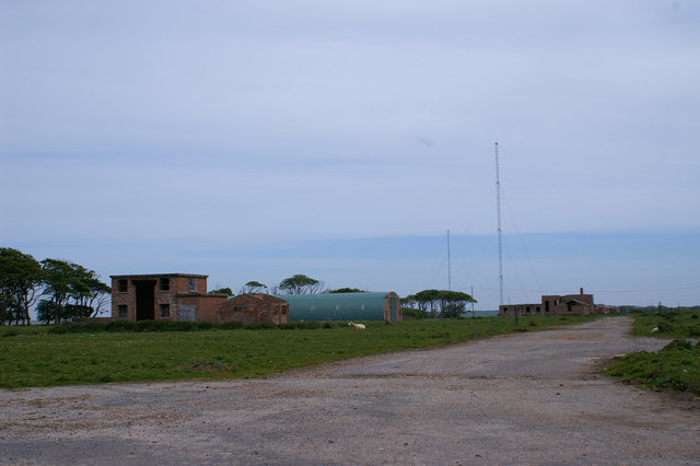
RNAS Rattray
Royal Navy Air Station Rattray, (RNAS Rattray; or HMS Merganser) and also known as Crimond Airfield, Crimond Aerodrome or Rattray Aerodrome was a Royal...
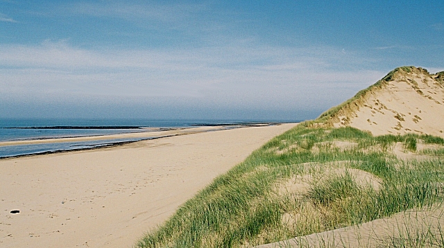
Rattray Head
Rattray Head (), historically Rattray Point, is a headland in Buchan, Aberdeenshire, on the north-east coast Scotland. To north lies Strathbeg Bay and...

Crimond Raceway
Crimond Raceway is the most northerly stock car track in the United Kingdom. It is located about a mile from the village of Crimond in Aberdeenshire, Scotland...
Crimond
Crimond is a village in Aberdeenshire, in the northeast of Scotland, located 9 miles (14 km) northwest of the port of Peterhead and just over 2 miles...
Nearby Amenities
Located within 500m of 57.612324,-1.8572876Have you been to Starnakeppie?
Leave your review of Starnakeppie below (or comments, questions and feedback).