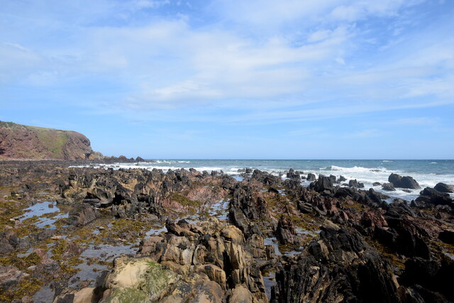
Craigeven Bay

Bay in Kincardineshire

Scotland

Craigeven Bay

Mains of Cowie The home farm for Cowie House, about 500 metres to the north east.  The farmhouse (LB9387 <span class="nowrap"><a title="http://portal.historicenvironment.scot/designation/LB9387" rel="nofollow ugc noopener" href="http://portal.historicenvironment.scot/designation/LB9387">Link</a><img style="margin-left:2px;" alt="External link" title="External link - shift click to open in new window" src="https://s1.geograph.org.uk/img/external.png" width="10" height="10"/></span> ) and extensive steadings to the right (LB9349 <span class="nowrap"><a title="http://portal.historicenvironment.scot/designation/LB9349" rel="nofollow ugc noopener" href="http://portal.historicenvironment.scot/designation/LB9349">Link</a><img style="margin-left:2px;" alt="External link" title="External link - shift click to open in new window" src="https://s1.geograph.org.uk/img/external.png" width="10" height="10"/></span> ) have separate C-listings.   In the foreground is the former A92 main road to Aberdeen.
Mains of Cowie Credit: Bill Harrison

The requested URL returned error: 429 Too Many Requests

If you have any feedback on the listing, please let us know in the comments section below.

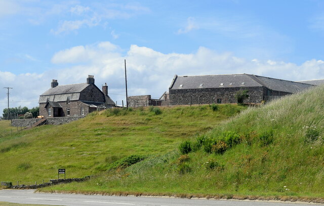
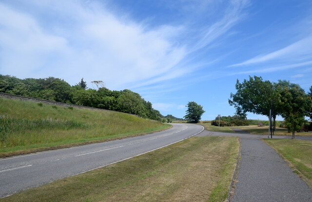
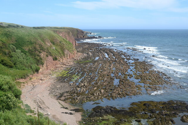
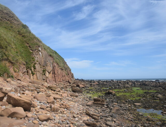
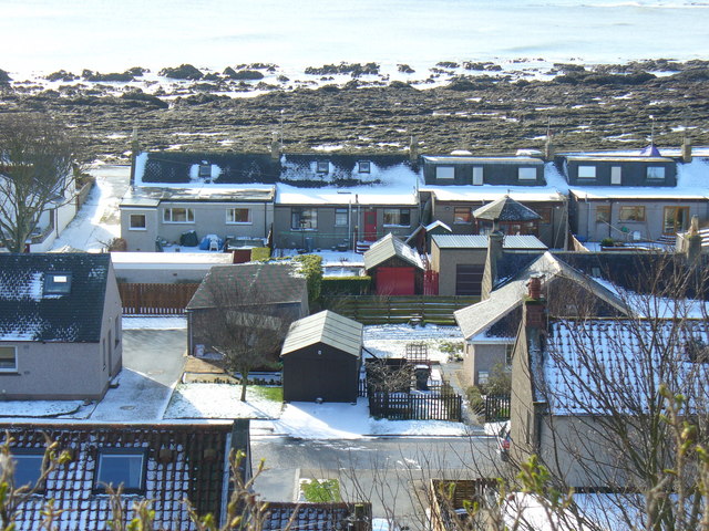
Craigeven Bay Images

Images are sourced within 2km of 56.977723/-2.1840375 or Grid Reference NO8887. Thanks to Geograph Open Source API. All images are credited.

Mains of Cowie The home farm for Cowie House, about 500 metres to the north east.  The farmhouse (LB9387 <span class="nowrap"><a title="http://portal.historicenvironment.scot/designation/LB9387" rel="nofollow ugc noopener" href="http://portal.historicenvironment.scot/designation/LB9387">Link</a><img style="margin-left:2px;" alt="External link" title="External link - shift click to open in new window" src="https://s1.geograph.org.uk/img/external.png" width="10" height="10"/></span> ) and extensive steadings to the right (LB9349 <span class="nowrap"><a title="http://portal.historicenvironment.scot/designation/LB9349" rel="nofollow ugc noopener" href="http://portal.historicenvironment.scot/designation/LB9349">Link</a><img style="margin-left:2px;" alt="External link" title="External link - shift click to open in new window" src="https://s1.geograph.org.uk/img/external.png" width="10" height="10"/></span> ) have separate C-listings.   In the foreground is the former A92 main road to Aberdeen.
Mains of Cowie
The home farm for Cowie House, about 500 metres to the north east. The farmhouse (LB9387 LinkExternal link ) and extensive steadings to the right (LB9349 LinkExternal link ) have separate C-listings. In the foreground is the former A92 main road to Aberdeen.
Former A92 road This was once the main road from Stonehaven to Aberdeen but has been downgraded since the Stonehaven by-pass was built.
Former A92 road
This was once the main road from Stonehaven to Aberdeen but has been downgraded since the Stonehaven by-pass was built.
Geological interest at Cowie Cliffs of the Cowie red sandstone formation (sedimentary bedrock formed approximately 426 to 431 million years ago in the Silurian Period) face onto a wave-cut platform of interbedded Castle Of Cowie sandstone and siltstone, formed at the same time.  In the foreground, much darker rocks of an intrusion of igneous magma, being part of the North Britain Siluro-Devonian calc-alkaline dyke suite: quartz, feldspar and porphyry formed approximately 359 to 444 million years ago in the Devonian and Silurian Periods.  All this happened when the land mass that was to become Scotland was south of the equator.
Geological interest at Cowie
Cliffs of the Cowie red sandstone formation (sedimentary bedrock formed approximately 426 to 431 million years ago in the Silurian Period) face onto a wave-cut platform of interbedded Castle Of Cowie sandstone and siltstone, formed at the same time. In the foreground, much darker rocks of an intrusion of igneous magma, being part of the North Britain Siluro-Devonian calc-alkaline dyke suite: quartz, feldspar and porphyry formed approximately 359 to 444 million years ago in the Devonian and Silurian Periods. All this happened when the land mass that was to become Scotland was south of the equator.
Scene at the Old Kirk Shore Red sandstone cliffs and boulders and a wave-cut platform of interbedded sandstone and mudstone.
Scene at the Old Kirk Shore
Red sandstone cliffs and boulders and a wave-cut platform of interbedded sandstone and mudstone.
Eroded sandstone cliff at the Old Kirk Shore
Wave-cut platform, Old Kirk Shore The interbedded sandstone and mudstone strata have been turned by 90 degrees and eroded to give a striking effect.
Wave-cut platform, Old Kirk Shore
The interbedded sandstone and mudstone strata have been turned by 90 degrees and eroded to give a striking effect.
Colourful sandstone cliff, Old Kirk Shore The ruin of St Mary's Church can just be seen on the hill in the background.
Colourful sandstone cliff, Old Kirk Shore
The ruin of St Mary's Church can just be seen on the hill in the background.
Wave-cut platform The vertical strata of sandstone and mudstone can be clearly seen in the blown-up photo.
Wave-cut platform
The vertical strata of sandstone and mudstone can be clearly seen in the blown-up photo.
Clubhouse, Stonehaven Golf Club
Ruin of St Mary's Chapel, Cowie The chapel associated with Cowie Castle was built in the 13th Century and suppressed after the Reformation although burials continued until the 20th Century.  Scheduled Monument SM5584 <span class="nowrap"><a title="http://portal.historicenvironment.scot/designation/SM5584" rel="nofollow ugc noopener" href="http://portal.historicenvironment.scot/designation/SM5584">Link</a><img style="margin-left:2px;" alt="External link" title="External link - shift click to open in new window" src="https://s1.geograph.org.uk/img/external.png" width="10" height="10"/></span>
Ruin of St Mary's Chapel, Cowie
The chapel associated with Cowie Castle was built in the 13th Century and suppressed after the Reformation although burials continued until the 20th Century. Scheduled Monument SM5584 LinkExternal link
Dead-house, St Mary's Chapel, Cowie The vaulted structure (also called a mort house) in the foreground was built to foil body snatchers supplying corpses to the anatomy schools at the universities in Aberdeen in the early 19th Century. B-listed: LB9383 <span class="nowrap"><a title="http://portal.historicenvironment.scot/designation/LB9383" rel="nofollow ugc noopener" href="http://portal.historicenvironment.scot/designation/LB9383">Link</a><img style="margin-left:2px;" alt="External link" title="External link - shift click to open in new window" src="https://s1.geograph.org.uk/img/external.png" width="10" height="10"/></span> .
Dead-house, St Mary's Chapel, Cowie
The vaulted structure (also called a mort house) in the foreground was built to foil body snatchers supplying corpses to the anatomy schools at the universities in Aberdeen in the early 19th Century. B-listed: LB9383 LinkExternal link .
Memorial to the Stonehaven lifeboat disaster Four of the crew of the lifeboat St George drowned while trying to enter Aberdeen Harbour after going to assist Grace Darling of Blyth, which foundered between Stonehaven and Aberdeen on 27 February 1874.
Memorial to the Stonehaven lifeboat disaster
Four of the crew of the lifeboat St George drowned while trying to enter Aberdeen Harbour after going to assist Grace Darling of Blyth, which foundered between Stonehaven and Aberdeen on 27 February 1874.
Road to nowhere This was once the main A92 road from Stonehaven to Aberdeen, but when the Stonehaven bypass was built, it was reconfigured as a southbound exit only from the bypass and the left-hand (northbound) lane ends in a turning loop a few hundred metres farther on, hence the 'no through road' sign.
Road to nowhere
This was once the main A92 road from Stonehaven to Aberdeen, but when the Stonehaven bypass was built, it was reconfigured as a southbound exit only from the bypass and the left-hand (northbound) lane ends in a turning loop a few hundred metres farther on, hence the 'no through road' sign.
Luxury lodges Coastal holiday lodges, which seem to be associated with Stonehaven Golf Club.
Luxury lodges
Coastal holiday lodges, which seem to be associated with Stonehaven Golf Club.
Start of the cycle path What was once the A92 main road from Stonehaven to Aberdeen has been reconfigured as an exit from the Stonehaven bypass (left-hand lane in the photo) and a somewhat lavish and little used cycle path to the right.   They are separated by 'Armco' crash barriers.
Start of the cycle path
What was once the A92 main road from Stonehaven to Aberdeen has been reconfigured as an exit from the Stonehaven bypass (left-hand lane in the photo) and a somewhat lavish and little used cycle path to the right. They are separated by 'Armco' crash barriers.
Divided road To the left, the southbound exit from the Stonehaven bypass and to the right a cycle and pedestrian path.
Divided road
To the left, the southbound exit from the Stonehaven bypass and to the right a cycle and pedestrian path.
View of the tracks... ...just north of Den of Cowie viaduct.
View of the tracks...
...just north of Den of Cowie viaduct.
Den of Cowie viaduct See Canmore listing 36947 (<span class="nowrap"><a title="https://canmore.org.uk/site/36947/skatie-shore-viaduct" rel="nofollow ugc noopener" href="https://canmore.org.uk/site/36947/skatie-shore-viaduct">Link</a><img style="margin-left:2px;" alt="External link" title="External link - shift click to open in new window" src="https://s1.geograph.org.uk/img/external.png" width="10" height="10"/></span> ), which calls it Skatie Shore viaduct, for more.  Built ca. 1850 by the Aberdeen Railway Company: <span class="nowrap"><a title="https://en.wikipedia.org/wiki/Aberdeen_Railway" rel="nofollow ugc noopener" href="https://en.wikipedia.org/wiki/Aberdeen_Railway">Link</a><img style="margin-left:2px;" alt="External link" title="External link - shift click to open in new window" src="https://s1.geograph.org.uk/img/external.png" width="10" height="10"/></span> .  A den is 'a narrow valley or ravine, usually wooded'.
Den of Cowie viaduct
See Canmore listing 36947 (LinkExternal link ), which calls it Skatie Shore viaduct, for more. Built ca. 1850 by the Aberdeen Railway Company: LinkExternal link . A den is 'a narrow valley or ravine, usually wooded'.
Show me another place!

Craigeven Bay is located at Grid Ref: NO8887 (Lat: 56.977723, Lng: -2.1840375)

Unitary Authority: Aberdeenshire

Police Authority: North East

What 3 Words

///configure.trek.removed. Near Stonehaven, Aberdeenshire

Related Wikis

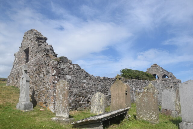
Chapel of St Mary and St Nathalan

The Chapel of St. Mary and St. Nathalan is a ruined chapel overlooking the North Sea immediately north of Stonehaven, in the Mearns of Scotland, along...

Cowie Castle

Cowie Castle is a ruined fortress in Aberdeenshire, Scotland. The site lies at the northern end of Stonehaven on the North Sea coast. To the immediate...

Limpet Mill railway station

Limpet Mill was a railway station in Kincardineshire, Scotland from 1849 to 1850 on the Aberdeen Railway. == History == This station was opened on 1 November...

Cowie, Aberdeenshire

Cowie is an historic fishing village in Kincardineshire, Scotland. This village has existed since the Middle Ages, but in current times it is effectively...

Nearby Amenities

Located within 500m of 56.977723,-2.1840375
Source: PGS
Lat/Long: 56.9762232/-2.1911222
Source: PGS
Lat/Long: 56.9766169/-2.1898754
Source: PGS
Lat/Long: 56.9766007/-2.1896528
Source: PGS
Lat/Long: 56.9765665/-2.1892296
Source: PGS
Lat/Long: 56.9765375/-2.1886292
Source: PGS
Lat/Long: 56.9764085/-2.1881213
Source: PGS
Lat/Long: 56.9766413/-2.1872437
Source: PGS
Lat/Long: 56.9766642/-2.1872105
Source: PGS
Lat/Long: 56.9766805/-2.1872193
Source: PGS
Lat/Long: 56.9768591/-2.1872356
Source: PGS
Lat/Long: 56.9772834/-2.1877226
Source: PGS
Lat/Long: 56.9775528/-2.1884963
Source: PGS
Lat/Long: 56.977969/-2.1884708
Source: PGS
Lat/Long: 56.9781575/-2.1883599
Source: PGS
Lat/Long: 56.9786758/-2.1875175
Source: PGS
Lat/Long: 56.9788142/-2.1865835
Source: PGS
Lat/Long: 56.9789953/-2.1853231
Source: PGS
Lat/Long: 56.97902/-2.1841882
Source: PGS
Lat/Long: 56.9785724/-2.1837775
Source: PGS
Lat/Long: 56.9781122/-2.1831058
Source: PGS
Lat/Long: 56.9786612/-2.1820594
Source: PGS
Lat/Long: 56.9788073/-2.1810624
Source: PGS
Lat/Long: 56.9790388/-2.1805388
Source: PGS
Lat/Long: 56.9792353/-2.1800826
Source: PGS
Lat/Long: 56.9794275/-2.1791813
Source: PGS
Lat/Long: 56.9791661/-2.1784241
Source: PGS
Lat/Long: 56.9792968/-2.1780212
Source: PGS
Lat/Long: 56.9794865/-2.1777845
Source: PGS
Lat/Long: 56.979513/-2.1774172
Source: PGS
Lat/Long: 56.97969/-2.1774261
Source: PGS
Lat/Long: 56.9799443/-2.1771779
Source: PGS
Lat/Long: 56.9803031/-2.1774826
Source: PGS
Lat/Long: 56.9800741/-2.1784414
Source: PGS
Lat/Long: 56.979671/-2.1796704
Source: PGS
Lat/Long: 56.9799187/-2.1806391
Source: PGS
Lat/Long: 56.980371/-2.1812267
Source: PGS
Lat/Long: 56.9808729/-2.1818072
Source: PGS
Lat/Long: 56.9811588/-2.1818887
Source: PGS
Lat/Long: 56.981265/-2.1819178
Source: PGS
Lat/Long: 56.981587/-2.1809715
Source: PGS
Lat/Long: 56.9817826/-2.1821064
Ruthery Head
Place: locality
Lat/Long: 56.9767187/-2.1874614
Craigeven Bay
Natural: bay
Source: NLS-OS-1st_Series
Lat/Long: 56.9775256/-2.1854444
The data included in this document is from www.openstreetmap.org. The data is made available under ODbL.

Have you been to Craigeven Bay?

Leave your review of Craigeven Bay below (or comments, questions and feedback).