Inganess Bay

Bay in Orkney

Scotland

Inganess Bay

Country road at Cobrance Farm
Country road at Cobrance Farm Credit: Oliver Dixon

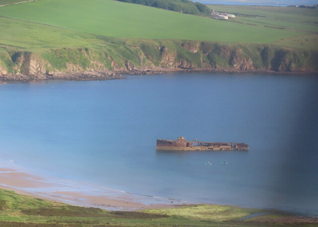
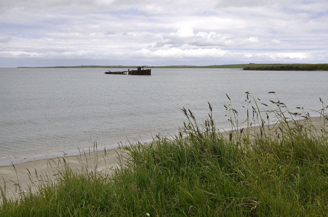
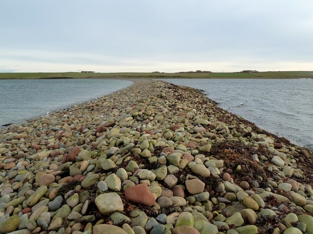
Inganess Bay is a picturesque bay located on the east coast of the Orkney Mainland, in Scotland. It is situated approximately 4 miles northeast of Kirkwall, the island’s main town. The bay is nestled between two headlands, Inganess Head to the north and Rerwick Head to the south, offering stunning views of the surrounding landscape.

Inganess Bay boasts a beautiful sandy beach, which stretches for about a mile along the bay. The sand is golden in color and is interspersed with small pebbles and shells, making it a popular spot for beachcombing. The beach is backed by grassy dunes, providing a peaceful and scenic setting for visitors to relax and enjoy the tranquil atmosphere.

The bay is also a haven for wildlife enthusiasts, as it hosts a variety of seabirds, including fulmars, gulls, and eiders. At low tide, the exposed rocky areas of the bay reveal a diverse range of marine life, such as crabs, starfish, and various types of seaweed, making it an interesting spot for nature enthusiasts to explore.

Inganess Bay is easily accessible by car, with a small parking area available near the beach. The bay is a popular destination for locals and tourists alike, offering opportunities for beach walks, picnics, and photography. It is also an ideal spot for water sports enthusiasts, with kayaking and paddleboarding being popular activities in the calm waters of the bay.

Overall, Inganess Bay is a scenic and peaceful haven that showcases the natural beauty of Orkney’s coastline, making it a must-visit destination for nature lovers and those seeking a tranquil escape.

If you have any feedback on the listing, please let us know in the comments section below.

Inganess Bay Images

Images are sourced within 2km of 58.975239/-2.8887812 or Grid Reference HY4910. Thanks to Geograph Open Source API. All images are credited.

Country road at Cobrance Farm
Cobrance farm Entrance to the farmyard.
Cobrance farm
Entrance to the farmyard.
Road, Yinstay A rather wide verge in Tankerness.
Road, Yinstay
A rather wide verge in Tankerness.
Scarpigar Scarpigar Farm
Scarpigar
Scarpigar Farm
White horses With the Loch of Tankerness in the background.
White horses
With the Loch of Tankerness in the background.
Farm track, Tankerness Hopefully the walkway sign means that you won't meet three strands of barbed wire along the way.
Farm track, Tankerness
Hopefully the walkway sign means that you won't meet three strands of barbed wire along the way.
Tankerness: the grass is stirring A hint of future growth in a late Spring, view towards Loch of Tankerness.
Tankerness: the grass is stirring
A hint of future growth in a late Spring, view towards Loch of Tankerness.
Wreck in Inganess Bay For more information see <a href="https://www.geograph.org.uk/photo/3094089">HY4708 : Wreck, Inganess Bay</a>.
Wreck in Inganess Bay
For more information see HY4708 : Wreck, Inganess Bay.
Wreck of the Juniata, Inganess Bay Ian appears to have done more than enough research for this old wreck here <a href="https://www.geograph.org.uk/photo/1117966">HY4708 : Wreck of the Juniata, Inganess Bay</a>
Wreck of the Juniata, Inganess Bay
Ian appears to have done more than enough research for this old wreck here HY4708 : Wreck of the Juniata, Inganess Bay
Kirkwall: landing at the airport A plane from Westray comes into land on the main runway at Kirkwall airport.
Kirkwall: landing at the airport
A plane from Westray comes into land on the main runway at Kirkwall airport.
Kirkwall: eastern end of airport runway Looking along the runway from the lane that passes the eastern edge of the airport.
Kirkwall: eastern end of airport runway
Looking along the runway from the lane that passes the eastern edge of the airport.
Long Ayre - Weethick A delightful ayre, or tombolo; it seems seldom visited yet full of interest.
It can be accessed at this, the western, end at low water but also from the far eastern end without difficulty - <a href="https://www.geograph.org.uk/photo/2715947">HY5009 : Very Long Ayre</a>
One can see that is largely submerged at high water.
Caused by long-shore drift of tides and streams, the banks hold back a good body of brackish water.
Some geo-science here - <span class="nowrap"><a title="http://en.wikipedia.org/wiki/Tombolo" rel="nofollow ugc noopener" href="http://en.wikipedia.org/wiki/Tombolo">Link</a><img style="margin-left:2px;" alt="External link" title="External link - shift click to open in new window" src="https://s1.geograph.org.uk/img/external.png" width="10" height="10"/></span>
Long Ayre - Weethick
A delightful ayre, or tombolo; it seems seldom visited yet full of interest. It can be accessed at this, the western, end at low water but also from the far eastern end without difficulty - HY5009 : Very Long Ayre One can see that is largely submerged at high water. Caused by long-shore drift of tides and streams, the banks hold back a good body of brackish water. Some geo-science here - LinkExternal link
Very Long Ayre The eastern end of the tombolo near the Hall of Yenstay.
A delightful and well formed Ayre - see also <a href="https://www.geograph.org.uk/photo/2715939">HY4909 : Long Ayre - Weethick</a>
Very Long Ayre
The eastern end of the tombolo near the Hall of Yenstay. A delightful and well formed Ayre - see also HY4909 : Long Ayre - Weethick
On the Ayre Long Ayre is a narrow ridge of shifting small boulders. On one side the sea, the other a mixture of sea- and steam-water.
There is some interesting and rare habitat here.
On the Ayre
Long Ayre is a narrow ridge of shifting small boulders. On one side the sea, the other a mixture of sea- and steam-water. There is some interesting and rare habitat here.
Scaregoose Everyone's heard of a Scarecrow.
Here, in Orkney, the geese (mostly Greylag) are so numerous as to be a very serious problem for farmers.
"..Orkney is currently an extreme example of wider concern.." (..regarding agricultural damage - RSPB Report) <span class="nowrap"><a title="http://www.wildlifeextra.com/go/news/greylag-goose009.html#cr" rel="nofollow ugc noopener" href="http://www.wildlifeextra.com/go/news/greylag-goose009.html#cr">Link</a><img style="margin-left:2px;" alt="External link" title="External link - shift click to open in new window" src="https://s1.geograph.org.uk/img/external.png" width="10" height="10"/></span> And <span class="nowrap"><a title="http://www.gooseshooting.co.uk/" rel="nofollow ugc noopener" href="http://www.gooseshooting.co.uk/">Link</a><img style="margin-left:2px;" alt="External link" title="External link - shift click to open in new window" src="https://s1.geograph.org.uk/img/external.png" width="10" height="10"/></span> (switch on speakers!)
This picture also shows the very rare feature of a double ayre (Long and Cloven)
Scaregoose
Everyone's heard of a Scarecrow. Here, in Orkney, the geese (mostly Greylag) are so numerous as to be a very serious problem for farmers. "..Orkney is currently an extreme example of wider concern.." (..regarding agricultural damage - RSPB Report) LinkExternal link And LinkExternal link (switch on speakers!) This picture also shows the very rare feature of a double ayre (Long and Cloven)
Cloven Ayre Loch of Swarsquoy.  Once closed by a tidal gate, possibly for fish trapping, it is now a haven for birds.
The Ayre possibly pre-dates the more obvious Long Ayre - both, of course, are very old.  The very rare feature (of two ayres) is sometimes called a Double Ayre.
Cloven Ayre
Loch of Swarsquoy. Once closed by a tidal gate, possibly for fish trapping, it is now a haven for birds. The Ayre possibly pre-dates the more obvious Long Ayre - both, of course, are very old. The very rare feature (of two ayres) is sometimes called a Double Ayre.
Cloven Ayre noust One of several well formed and historic nousts (boat shelters). Not well marked on modern maps (cartographically lost!), they may indeed be very old, perhaps (it is suggested) even Viking in origin.
"Nousts....northern bank of the outer lagoon-evidence of its use as a harbour, perhaps as far back as Viking times...." <span class="nowrap"><a title="http://hypnodons.blogspot.com/2011_04_01_archive.html" rel="nofollow ugc noopener" href="http://hypnodons.blogspot.com/2011_04_01_archive.html">Link</a><img style="margin-left:2px;" alt="External link" title="External link - shift click to open in new window" src="https://s1.geograph.org.uk/img/external.png" width="10" height="10"/></span>
Marked on this map <span class="nowrap"><a title="http://maps.nls.uk/os/25inch/view/?sid=75136374" rel="nofollow ugc noopener" href="http://maps.nls.uk/os/25inch/view/?sid=75136374">Link</a><img style="margin-left:2px;" alt="External link" title="External link - shift click to open in new window" src="https://s1.geograph.org.uk/img/external.png" width="10" height="10"/></span> as is the tidal gate to Loch of Swarsquoy <a href="https://www.geograph.org.uk/photo/2727729">HY5009 : Cloven Ayre</a>
Cloven Ayre noust
One of several well formed and historic nousts (boat shelters). Not well marked on modern maps (cartographically lost!), they may indeed be very old, perhaps (it is suggested) even Viking in origin. "Nousts....northern bank of the outer lagoon-evidence of its use as a harbour, perhaps as far back as Viking times...." LinkExternal link Marked on this map LinkExternal link as is the tidal gate to Loch of Swarsquoy HY5009 : Cloven Ayre
The Double Ayres of Weethick The very rare Double Ayre feature - the only one in Orkney.
Long Ayre, right, separates the sea from its tidal pool and Cloven Ayre, left, protects the Loch of Swarsquoy.
The Double Ayres of Weethick
The very rare Double Ayre feature - the only one in Orkney. Long Ayre, right, separates the sea from its tidal pool and Cloven Ayre, left, protects the Loch of Swarsquoy.
Show me another place!

Inganess Bay is located at Grid Ref: HY4910 (Lat: 58.975239, Lng: -2.8887812)

Unitary Authority: Orkney Islands

Police Authority: Highlands and Islands

What 3 Words

///tripped.undertone.glass. Near Tankerness, Orkney Islands

Nearby Locations

Inganess Bay

Related Wikis

Kirkwall Airport

Kirkwall Airport (IATA: KOI, ICAO: EGPA) (Scottish Gaelic: Port-adhair Bhaile na h-Eaglais) is the main airport serving Orkney in Scotland. It is located...

St Andrews, Orkney

St Andrews is a parish on Mainland, Orkney in Scotland. It is located east of the town of Kirkwall and the parish of St Ola and lies north of Holm and...

Loch of Tankerness

Loch of Tankerness is a large, lowland, freshwater loch on the Orkney mainland in Scotland. The loch is roughly triangular in shape and is shallow with...

Kirkwall Grammar School

Kirkwall Grammar School is a secondary school in Kirkwall, Orkney, Scotland. It was established in c. 1200. The current school building was opened in 2014...

Have you been to Inganess Bay?

Leave your review of Inganess Bay below (or comments, questions and feedback).