Bay of Moclett

Bay in Orkney

Scotland

Bay of Moclett

Pits, Bull Flag, Papa Westray, Orkney From <span class="nowrap"><a title="http://canmore.org.uk/event/639213" rel="nofollow ugc noopener" href="http://canmore.org.uk/event/639213">Link</a><img style="margin-left:2px;" alt="External link" title="External link - shift click to open in new window" src="https://s1.geograph.org.uk/img/external.png" width="10" height="10"/></span> : "A series of oval/amorphous scooped areas or pits may be kelp pits or quarry hollows. They measure 8m by 4m by 1m deep. They are filled with loose stone and are partially covered with grass."
Pits, Bull Flag, Papa Westray, Orkney Credit: Claire Pegrum

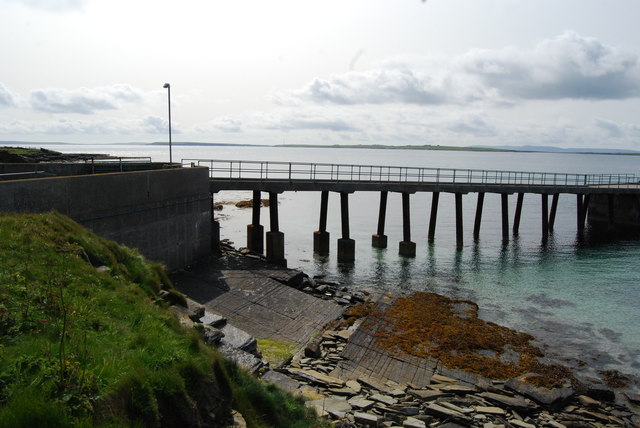
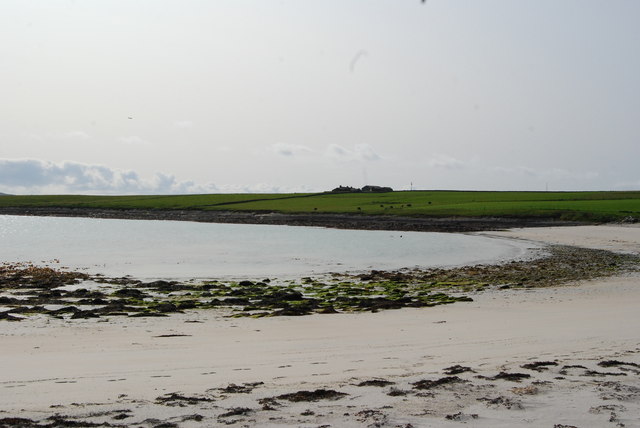
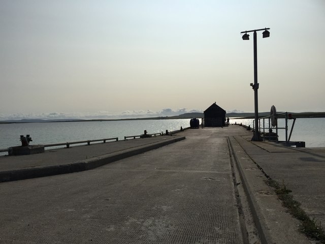
The Bay of Moclett is a picturesque bay located in the Orkney Islands, a group of islands situated off the northeastern coast of mainland Scotland. This bay is nestled on the eastern coast of South Ronaldsay, one of the larger islands in the archipelago. The bay's coordinates are approximately 58.8°N latitude and 2.95°W longitude.

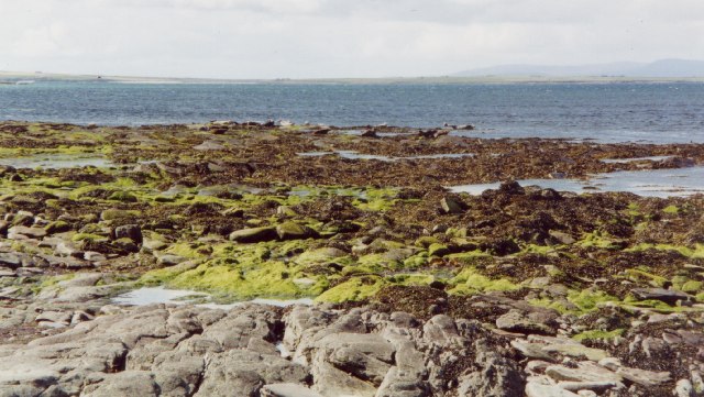
The Bay of Moclett boasts stunning natural beauty, with its peaceful and tranquil surroundings. Its sandy beach stretches for about half a mile, offering visitors a perfect spot for relaxation and leisurely walks. The bay is also known for its crystal-clear waters, which are ideal for swimming and water activities during warmer months.

Surrounding the bay, visitors can admire the rugged coastline and towering cliffs, providing a dramatic backdrop to the serene waters. The area is abundant in wildlife, making it a popular spot for birdwatching and nature enthusiasts. Seals are often spotted lounging on nearby rocks, and a variety of seabirds can be observed soaring above the bay.

The Bay of Moclett is also steeped in history, with archaeological remains in the surrounding area dating back thousands of years. There are several ancient burial sites and standing stones nearby, offering insight into the rich cultural heritage of the Orkney Islands.

Overall, the Bay of Moclett is a captivating destination that combines natural beauty, recreational opportunities, and historical significance. Its idyllic setting and peaceful atmosphere make it a must-visit location for those exploring the Orkney Islands.

If you have any feedback on the listing, please let us know in the comments section below.

Bay of Moclett Images

Images are sourced within 2km of 59.322924/-2.9046965 or Grid Reference HY4848. Thanks to Geograph Open Source API. All images are credited.

Pits, Bull Flag, Papa Westray, Orkney From <span class="nowrap"><a title="http://canmore.org.uk/event/639213" rel="nofollow ugc noopener" href="http://canmore.org.uk/event/639213">Link</a><img style="margin-left:2px;" alt="External link" title="External link - shift click to open in new window" src="https://s1.geograph.org.uk/img/external.png" width="10" height="10"/></span> : "A series of oval/amorphous scooped areas or pits may be kelp pits or quarry hollows. They measure 8m by 4m by 1m deep. They are filled with loose stone and are partially covered with grass."
Pits, Bull Flag, Papa Westray, Orkney
From LinkExternal link : "A series of oval/amorphous scooped areas or pits may be kelp pits or quarry hollows. They measure 8m by 4m by 1m deep. They are filled with loose stone and are partially covered with grass."
Track to Blossom As we feared that we were getting short of time we decided to follow a track marked on the map rather than continue round the shore. It started out fine, as you can see, but subsequently deteriorated and eventually vanished at the garden wall of Sheepheight, necessitating a diversion round Sheepheight and climbing over a couple of fences. Not recommended! The ruins on the left are at Blossom.
Track to Blossom
As we feared that we were getting short of time we decided to follow a track marked on the map rather than continue round the shore. It started out fine, as you can see, but subsequently deteriorated and eventually vanished at the garden wall of Sheepheight, necessitating a diversion round Sheepheight and climbing over a couple of fences. Not recommended! The ruins on the left are at Blossom.
Blossom The house and steading at Blossom are derelict and now occupied only by sheep.
Blossom
The house and steading at Blossom are derelict and now occupied only by sheep.
Papa Westray coastline The rock forms a flat shelf at this point on the coast, and the waves were sweeping across it.
Papa Westray coastline
The rock forms a flat shelf at this point on the coast, and the waves were sweeping across it.
Gayfield Trig Point
Gayfield Trig Point
A View Across The Loch
The pier on Papa Westray
Toilet and Waiting Room on Papa Westray
Bay of Moclett, Papa Westray
Footpath on Papa Westray
Moclett Pier on Papa Westray
On Papa Westray
On Papa Westray
Papa Westray
Papa Westray
Former Fence The satellite view shows several small fields here, but the wire of the fences between them has been removed so they are now one large field with occasional fence posts.
Former Fence
The satellite view shows several small fields here, but the wire of the fences between them has been removed so they are now one large field with occasional fence posts.
Insulated Containers One is labelled 'Papay Frozen' and the other 'Papay Chilled'. We could only speculate whether this referred to island produce on its way out, or supplies coming in for the shop in Papay, and whether the containers were full or empty.
Insulated Containers
One is labelled 'Papay Frozen' and the other 'Papay Chilled'. We could only speculate whether this referred to island produce on its way out, or supplies coming in for the shop in Papay, and whether the containers were full or empty.
Moclett The bay at Moclett, complete with public toilets. Orkney Islands Council is to be congratulated on its provision of public toilets, which are both ubiquitous and clean.
Moclett
The bay at Moclett, complete with public toilets. Orkney Islands Council is to be congratulated on its provision of public toilets, which are both ubiquitous and clean.
Papa Sound near Backaskail, Papa Westray, Orkney Looking south west towards Westray
Papa Sound near Backaskail, Papa Westray, Orkney
Looking south west towards Westray
Marsh Orchid on grass verge, Papa Westray
Show me another place!

Bay of Moclett is located at Grid Ref: HY4848 (Lat: 59.322924, Lng: -2.9046965)

Unitary Authority: Orkney Islands

Police Authority: Highlands and Islands

What 3 Words

///motel.robe.bolsters. Near Pierowall, Orkney Islands

Related Wikis

Holland House, Papa Westray

Holland Farm is a historic farm complex located on the island of Papa Westray in Orkney, Scotland. The two-storey harled flagstone house with crow-stepped...

Knap of Howar

The Knap of Howar () on the island of Papa Westray in Orkney, Scotland is a Neolithic farmstead which may be the oldest preserved stone house in northern...

Papa Westray

Papa Westray () (Scots: Papa Westree), also known as Papay, is one of the Orkney Islands in Scotland, United Kingdom. The fertile soil has long been a...

Papa Westray Airport

Papa Westray Airport (IATA: PPW, ICAO: EGEP) is located 22 NM (41 km; 25 mi) north of Kirkwall Airport on Papa Westray, Orkney Islands, Scotland. The facility...

Have you been to Bay of Moclett?

Leave your review of Bay of Moclett below (or comments, questions and feedback).