Bates Hill

Settlement in Yorkshire

England

Bates Hill

Old milepost The northernmost surviving milepost on the Barnsley to Pontefract route, A628.   It is about a mile north of High Ackworth and at the top of Castle Syke Hill.   The top 12cm of the casting was broken off many years ago and since 2019 the top of the backing stone has also been broken off.  It was known to have been last painted in 2012.
Old milepost Credit: Chris Minto

Bates Hill is a picturesque village located in the county of Yorkshire, England. Situated amidst rolling hills and surrounded by lush greenery, this idyllic village offers a tranquil retreat for both residents and visitors alike.

The village is known for its charming architecture, with many of the buildings dating back to the 19th century. The local stone cottages and houses add to the village's character and charm. The main street is lined with quaint shops, cafes, and pubs, creating a warm and inviting atmosphere.

Bates Hill is also famous for its natural beauty. The surrounding countryside offers stunning views of the Yorkshire Dales, with hiking and walking trails that attract outdoor enthusiasts throughout the year. The village is also home to a beautiful park, where locals and visitors can enjoy picnics, relax, and appreciate the surrounding landscape.

The community in Bates Hill is close-knit and welcoming. Residents take pride in their village and actively participate in various community events and festivals held throughout the year. The village hosts an annual summer fair, showcasing local crafts, food, and entertainment.

For history enthusiasts, Bates Hill boasts a rich heritage. The village is home to a small museum that displays artifacts and documents relating to the area's past, offering a glimpse into its fascinating history.

With its stunning countryside, charming architecture, and vibrant community spirit, Bates Hill is a must-visit destination for those seeking a quintessential Yorkshire experience.

If you have any feedback on the listing, please let us know in the comments section below.
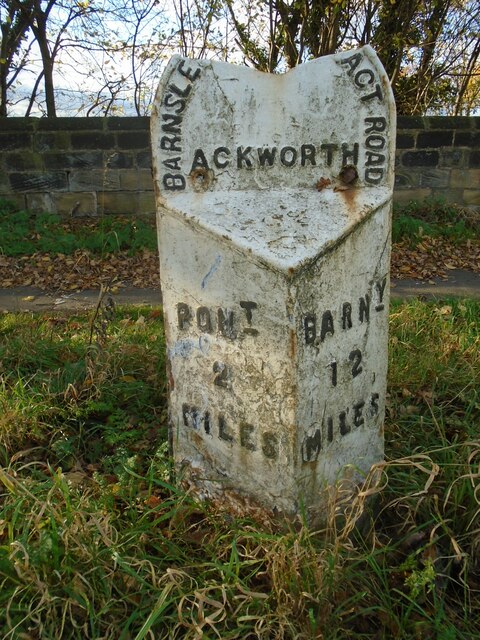
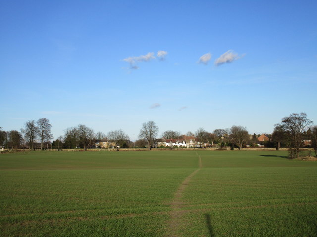
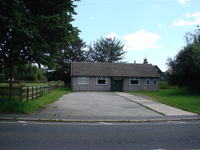
Bates Hill Images

Images are sourced within 2km of 53.674453/-1.305154 or Grid Reference SE4620. Thanks to Geograph Open Source API. All images are credited.

Old milepost The northernmost surviving milepost on the Barnsley to Pontefract route, A628.   It is about a mile north of High Ackworth and at the top of Castle Syke Hill.   The top 12cm of the casting was broken off many years ago and since 2019 the top of the backing stone has also been broken off.  It was known to have been last painted in 2012.
Old milepost
The northernmost surviving milepost on the Barnsley to Pontefract route, A628. It is about a mile north of High Ackworth and at the top of Castle Syke Hill. The top 12cm of the casting was broken off many years ago and since 2019 the top of the backing stone has also been broken off. It was known to have been last painted in 2012.
Hundhill Trig Point Flush Bracket S4242
Old guidestone This Grade II Listed guidestone which was pushed over in 2016 has now been set upright, fortunately suffering no damage.   It is at a gateless field entrance and a nearby hedge has been removed so that it is easily seen.  It is at the junction of Moor Lane and Hardwick Road which may have been an old route from The Great North Road towards Wakefield.  Faint inscribed legends partially legible on three faces are Doncaster, Pontefract Road and Hardwick.  Listing - 1313231.
Old guidestone
This Grade II Listed guidestone which was pushed over in 2016 has now been set upright, fortunately suffering no damage. It is at a gateless field entrance and a nearby hedge has been removed so that it is easily seen. It is at the junction of Moor Lane and Hardwick Road which may have been an old route from The Great North Road towards Wakefield. Faint inscribed legends partially legible on three faces are Doncaster, Pontefract Road and Hardwick. Listing - 1313231.
Old guidestone A view of the other two faces of the re-erected guidestone.   It has suffered slight damage during resetting upright but that will weather in time.   Hardwick Road is to the left.
Old guidestone
A view of the other two faces of the re-erected guidestone. It has suffered slight damage during resetting upright but that will weather in time. Hardwick Road is to the left.
Old milestone Another of the 615 original milestones erected for the West Riding County Council in 1893/94.   The contractor was Gill Stead and Son of Heckmondwike.   It was last repainted in 2004 and is set in a concrete base.  This is one of those cast by Brayshaw & Booth, Liversedge.
Old milestone
Another of the 615 original milestones erected for the West Riding County Council in 1893/94. The contractor was Gill Stead and Son of Heckmondwike. It was last repainted in 2004 and is set in a concrete base. This is one of those cast by Brayshaw & Booth, Liversedge.
Old milestone The late 19C West Riding CC milestone on the A639, Hardwick Road, Carleton.  The original attached casting was stolen before August 2007.   Did the thief paint on the crossed swords?   But the 7 is a mystery.  It is not a mileage that can be accounted for looking at the other milestones on this road.  Without its metal attachment this shows how the stone was worked for its fixing in 4 places.   There are 6 of these milestones between Barnsdale Bar and Pontefract with just one remaining north of the town towards Leeds.  Grade II listed 1313284
Old milestone
The late 19C West Riding CC milestone on the A639, Hardwick Road, Carleton. The original attached casting was stolen before August 2007. Did the thief paint on the crossed swords? But the 7 is a mystery. It is not a mileage that can be accounted for looking at the other milestones on this road. Without its metal attachment this shows how the stone was worked for its fixing in 4 places. There are 6 of these milestones between Barnsdale Bar and Pontefract with just one remaining north of the town towards Leeds. Grade II listed 1313284
Sandy Gate Lane, Ackworth
Ackworth Plague Stone
East Hardwick, disused well
Footpath to East Hardwick
Line of trees Hundhill Farm beyond.
Line of trees
Hundhill Farm beyond.
View towards Went Hill This area is drained by the River Went and its tributaries. Went Hill forms an obstacle to the river's eastward flow which it overcomes by flowing through a narrow gap at Wentbridge.
View towards Went Hill
This area is drained by the River Went and its tributaries. Went Hill forms an obstacle to the river's eastward flow which it overcomes by flowing through a narrow gap at Wentbridge.
Well worn steps on this stile
Water tower near High Ackworth This must be post-war, of the space-age variety.
An impressive amount of information about the local water supply can be found here: <a href="https://www.geograph.org.uk/photo/339726">SE4418 : Ackworth Water Tower</a>.
Water tower near High Ackworth
This must be post-war, of the space-age variety. An impressive amount of information about the local water supply can be found here: SE4418 : Ackworth Water Tower.
Looking towards Carleton Much of the village sits on a low ridge.
Looking towards Carleton
Much of the village sits on a low ridge.
View towards Fletcher's Spring Covert
Field of oilseed rape Carleton and Pontefract in the distance on the right.
Field of oilseed rape
Carleton and Pontefract in the distance on the right.
Magnesian limestone ridge A belt of magnesian limestone lies to the east of the Pennines. 
Between Darrington and Wentbridge it forms a narrow easily identified ridge.
Magnesian limestone ridge
A belt of magnesian limestone lies to the east of the Pennines. Between Darrington and Wentbridge it forms a narrow easily identified ridge.
Show me another place!

Bates Hill is located at Grid Ref: SE4620 (Lat: 53.674453, Lng: -1.305154)

Division: West Riding

Unitary Authority: Wakefield

Police Authority: West Yorkshire

What 3 Words

///herb.skin.battle. Near Pontefract, West Yorkshire

Nearby Locations

Carleton Bates Hill

Related Wikis

Carleton High School

Carleton High School is a coeducational secondary school with academy status, at Carleton in Pontefract, West Yorkshire, England. It is a part of the Pontefract...

Carleton, West Yorkshire

Carleton is a small village on the southern outskirts of Pontefract in West Yorkshire, England. The village is home to the parish church of St Michael...

King's School, Pontefract

The King's School is a coeducational secondary school with academy status, located in Pontefract, West Yorkshire, England. It is one of the four oldest...

East Hardwick

East Hardwick is a village and civil parish in the City of Wakefield in West Yorkshire, England. It has a population of 191, reducing to 173 at the 2011...

Nearby Amenities

Located within 500m of 53.674453,-1.305154
Bus Stop
Hardwick Road Railway Bridge
Bus: yes
Naptan AtcoCode: 450015896
Naptan Bearing: SE
Naptan CommonName: Hardwick Road Railway Bridge
Naptan Crossing: Ashbourne Grove
Naptan Landmark: Unknown
Naptan ShortCommonName: Railway Bridge
Naptan Street: Hardwick Road
Naptan Verified: no
Public Transport: platform
Source: naptan_import
Lat/Long: 53.6739523/-1.3089344
Bus Stop
Hardwick Road Brookdale Avenue
Bus: yes
Local Ref: 45025397
Naptan AtcoCode: 450025397
Naptan Bearing: NW
Naptan CommonName: Hardwick Road Brookdale Avenue
Naptan Crossing: Nr-At Brookadale Avenue
Naptan Indicator: Stop 45025397
Naptan PlusbusZoneRef: LEEDS
Naptan ShortCommonName: Moor Lane
Naptan Street: Hardwick Road
Naptan Verified: no
Public Transport: platform
Source: naptan_import
Lat/Long: 53.6739889/-1.3091003
Bus Stop
Hardwick Road Lynwood Crescent
Bus: yes
Local Ref: 45025810
Naptan AtcoCode: 450025810
Naptan Bearing: S
Naptan CommonName: Hardwick Road Lynwood Crescent
Naptan Crossing: Lynwood Gardens
Naptan Indicator: Stop 45025810
Naptan PlusbusZoneRef: LEEDS
Naptan ShortCommonName: Lynwood Crescent
Naptan Street: Hardwick Road
Naptan Verified: no
Public Transport: platform
Source: naptan_import
Lat/Long: 53.6772786/-1.3107548
Bus Stop
Bus: yes
Public Transport: platform
Lat/Long: 53.6764175/-1.300544
Bus Stop
Bus: yes
Public Transport: platform
Lat/Long: 53.6766781/-1.3004233
The data included in this document is from www.openstreetmap.org. The data is made available under ODbL.

Have you been to Bates Hill?

Leave your review of Bates Hill below (or comments, questions and feedback).