Bay of Houton

Bay in Orkney

Scotland

Bay of Houton

Pier at Houton Ferry Terminal Used by the Ferry to Hoy and Flotta.
Pier at Houton Ferry Terminal Credit: Graeme Yuill

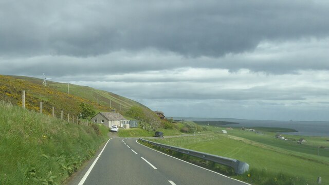
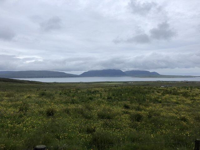
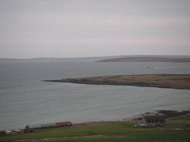
The Bay of Houton is a picturesque natural harbor located on the west coast of the Orkney Mainland, Scotland. It is situated approximately 9 miles southwest of Kirkwall, the largest town in the Orkney Islands. The bay stretches over a kilometer in length and is sheltered by surrounding hills, providing a calm and tranquil environment.

With its idyllic setting, the Bay of Houton is a popular destination for boating enthusiasts and nature lovers alike. The bay serves as a launching point for various water-based activities such as sailing, kayaking, and fishing. Its deep waters and convenient location make it an ideal spot for exploring the surrounding coastline and nearby islands.

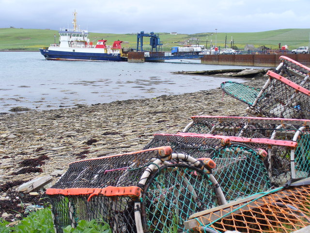
The bay is also home to the Houton Ferry Terminal, which offers regular services to the nearby islands of Hoy and Flotta. This makes the Bay of Houton an important transportation hub for both locals and tourists, providing easy access to the other islands and their attractions.

Surrounding the bay, visitors will find a diverse range of flora and fauna, including seabirds, seals, and sometimes even dolphins. The nearby Houton Woods add to the area's natural beauty, offering scenic walking trails and opportunities for wildlife spotting.

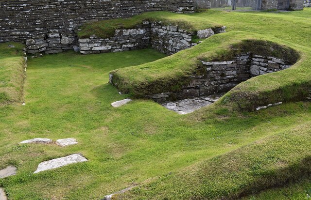
The Bay of Houton is not only a haven for outdoor enthusiasts but also a place of historical interest. Nearby, the remains of a Viking settlement at Bu, dating back to the 11th century, can be explored. This adds a cultural dimension to the bay, giving visitors a glimpse into Orkney's rich history.

Overall, the Bay of Houton is a charming and versatile destination, combining natural beauty, recreational activities, and historical significance.

If you have any feedback on the listing, please let us know in the comments section below.

Bay of Houton Images

Images are sourced within 2km of 58.915187/-3.18706 or Grid Reference HY3103. Thanks to Geograph Open Source API. All images are credited.

Pier at Houton Ferry Terminal Used by the Ferry to Hoy and Flotta.
Pier at Houton Ferry Terminal
Used by the Ferry to Hoy and Flotta.
House under construction, Houton, Orkney An unusually modern design for Orkney in a great location overlooking Bay of Houton.
House under construction, Houton, Orkney
An unusually modern design for Orkney in a great location overlooking Bay of Houton.
A964 near Houton, Orkney
A field drain near Workwell
Grassy fields at Houton
Unloading the ferry at Houton
Car parks for the ferry
Holm of Houton Seen from the Hoy Ferry.
Holm of Houton
Seen from the Hoy Ferry.
Scapa Flow Lodges Self-catering accommodation overlooking Scapa Flow
Scapa Flow Lodges
Self-catering accommodation overlooking Scapa Flow
Ruined buildings near Crya
Moorland footpath Goes to Hill of Midland. The mountains of Hoy in the distance
Moorland footpath
Goes to Hill of Midland. The mountains of Hoy in the distance
Abandoned croft near Crya
Track to Culdigo
Track to Culdigo
View to the Isle of Hoy from Scorradale Road At far right of the photo, the lighthouse at Graemsay is visible
View to the Isle of Hoy from Scorradale Road
At far right of the photo, the lighthouse at Graemsay is visible
Orphir - Earl's Bu - Foundations of Drinking Hall It is thought that these earthworks and stones are the foundations of an ancient 'Drinking Hall' known as Earl's Bu.
If this is correct, then in 1136 they witnessed the murder of Svenn Brestrope.
During Earl Paul's Yule feasts at his Bu there was an exchange of insults between Sweyn Asleifsson and Sweyn Breastrope (Svenn Brestrope), a colleague of Asleifsson's father. This culminated in the hot-headed young Asleifsson killing Brestrope.
The murderer fled to Egilsay and from thence was dispatched to Tiree by Bishop William the Old. He was given refuge there by a chieftain by the name of Holbodi. Somewhat later young Asleifsson returned to Orkney and managed to kidnap Earl Paul on the island of Rousay, "spiriting him away and leaving the Earldom open for Rognvald II to step in and assume control."
According to other references in the Orkneyinga Saga, Earl Haraldr died at Orphir in 1127 and the Bu (or hall) subsequently belonged to Earl Paul II (1136-7) and Earl Rognvaldr II (1154) who commissioned <a href="https://www.geograph.org.uk/photo/7549699">HY4410 : Kirkwall - St Magnus Cathedral from the Bishop's Palace</a>. Earl Haraldr Maddadson was said to be in hiding at the Bu of Orphir in 1154. (Information from nearby HES plaque and from an adapted translation of the Orkneyinga Saga online).
See Canmore website: <span class="nowrap"><a title="https://canmore.org.uk/site/1970/orphir-earls-bu" rel="nofollow ugc noopener" href="https://canmore.org.uk/site/1970/orphir-earls-bu">Link</a><img style="margin-left:2px;" alt="External link" title="External link - shift click to open in new window" src="https://s1.geograph.org.uk/img/external.png" width="10" height="10"/></span>
HES Website: <span class="nowrap"><a title="https://www.historicenvironment.scot/visit-a-place/places/earls-bu-and-church-orphir" rel="nofollow ugc noopener" href="https://www.historicenvironment.scot/visit-a-place/places/earls-bu-and-church-orphir">Link</a><img style="margin-left:2px;" alt="External link" title="External link - shift click to open in new window" src="https://s1.geograph.org.uk/img/external.png" width="10" height="10"/></span>
See also <a href="https://www.geograph.org.uk/photo/7560896">HY3304 : Orphir - Earl's Bu - Stones and recesses</a>
This site is adjacent to <a href="https://www.geograph.org.uk/photo/7560899">HY3304 : Orphir - St Nicholas Round Kirk (remains)</a>
Orphir - Earl's Bu - Foundations of Drinking Hall
It is thought that these earthworks and stones are the foundations of an ancient 'Drinking Hall' known as Earl's Bu. If this is correct, then in 1136 they witnessed the murder of Svenn Brestrope. During Earl Paul's Yule feasts at his Bu there was an exchange of insults between Sweyn Asleifsson and Sweyn Breastrope (Svenn Brestrope), a colleague of Asleifsson's father. This culminated in the hot-headed young Asleifsson killing Brestrope. The murderer fled to Egilsay and from thence was dispatched to Tiree by Bishop William the Old. He was given refuge there by a chieftain by the name of Holbodi. Somewhat later young Asleifsson returned to Orkney and managed to kidnap Earl Paul on the island of Rousay, "spiriting him away and leaving the Earldom open for Rognvald II to step in and assume control." According to other references in the Orkneyinga Saga, Earl Haraldr died at Orphir in 1127 and the Bu (or hall) subsequently belonged to Earl Paul II (1136-7) and Earl Rognvaldr II (1154) who commissioned HY4410 : Kirkwall - St Magnus Cathedral from the Bishop's Palace. Earl Haraldr Maddadson was said to be in hiding at the Bu of Orphir in 1154. (Information from nearby HES plaque and from an adapted translation of the Orkneyinga Saga online). See Canmore website: LinkExternal link HES Website: LinkExternal link See also HY3304 : Orphir - Earl's Bu - Stones and recesses This site is adjacent to HY3304 : Orphir - St Nicholas Round Kirk (remains)
Orphir - Earl's Bu - Stones and recesses Part of the foundations of the C12th Earl's Bu at Orphir on Mainland, Orkney.
See <a href="https://www.geograph.org.uk/photo/7560879">HY3304 : Orphir - Earl's Bu - Foundations of Drinking Hall</a> for more information on the history of this former Drinking Hall.
This site is adjacent to <a href="https://www.geograph.org.uk/photo/7560899">HY3304 : Orphir - St Nicholas Round Kirk (remains)</a>
See Canmore website for information on the site: <span class="nowrap"><a title="https://canmore.org.uk/site/1970/orphir-earls-bu" rel="nofollow ugc noopener" href="https://canmore.org.uk/site/1970/orphir-earls-bu">Link</a><img style="margin-left:2px;" alt="External link" title="External link - shift click to open in new window" src="https://s1.geograph.org.uk/img/external.png" width="10" height="10"/></span>
HES Website: <span class="nowrap"><a title="https://www.historicenvironment.scot/visit-a-place/places/earls-bu-and-church-orphir" rel="nofollow ugc noopener" href="https://www.historicenvironment.scot/visit-a-place/places/earls-bu-and-church-orphir">Link</a><img style="margin-left:2px;" alt="External link" title="External link - shift click to open in new window" src="https://s1.geograph.org.uk/img/external.png" width="10" height="10"/></span>
Orphir - Earl's Bu - Stones and recesses
Part of the foundations of the C12th Earl's Bu at Orphir on Mainland, Orkney. See HY3304 : Orphir - Earl's Bu - Foundations of Drinking Hall for more information on the history of this former Drinking Hall. This site is adjacent to HY3304 : Orphir - St Nicholas Round Kirk (remains) See Canmore website for information on the site: LinkExternal link HES Website: LinkExternal link
Orphir - St Nicholas Round Kirk (remains) The apsidal eastern remains of the former round kirk of St Nicholas at Orphir.
The ring of gravel marks its original footprint.
From the Canmore website: "The remains of a Romanesque Church, dedicated to St Nicholas, which has been circular on plan with an E apse, stands at the E end of the now demolished parish church. It is unique in Scotland as having been built after the model of the Church of the Holy Sepulchre in Jerusalem, through Scandinavian prototypes, and it can be dated between AD 1090 and 1160. A reference under the year 1136 in the 'Orkneyinga Saga', mentions this church, although Wainwright argues that the writer may have been describing the church as he knew it about a century later. Wainwright would also place the erection of the church after 1100 on comparison with three, very similar, churches at Praha (Prague)."
See also <a href="https://www.geograph.org.uk/photo/7560901">HY3304 : Orphir - St Nicholas Round Kirk apse from northeast</a>
The church is adjacent to <a href="https://www.geograph.org.uk/photo/7560879">HY3304 : Orphir - Earl's Bu - Foundations of Drinking Hall</a>
HES Website: <span class="nowrap"><a title="https://www.historicenvironment.scot/visit-a-place/places/earls-bu-and-church-orphir" rel="nofollow ugc noopener" href="https://www.historicenvironment.scot/visit-a-place/places/earls-bu-and-church-orphir">Link</a><img style="margin-left:2px;" alt="External link" title="External link - shift click to open in new window" src="https://s1.geograph.org.uk/img/external.png" width="10" height="10"/></span>
Canmore website: <span class="nowrap"><a title="https://canmore.org.uk/site/1962/orphir-st-nicholass-church" rel="nofollow ugc noopener" href="https://canmore.org.uk/site/1962/orphir-st-nicholass-church">Link</a><img style="margin-left:2px;" alt="External link" title="External link - shift click to open in new window" src="https://s1.geograph.org.uk/img/external.png" width="10" height="10"/></span>
Orphir - St Nicholas Round Kirk (remains)
The apsidal eastern remains of the former round kirk of St Nicholas at Orphir. The ring of gravel marks its original footprint. From the Canmore website: "The remains of a Romanesque Church, dedicated to St Nicholas, which has been circular on plan with an E apse, stands at the E end of the now demolished parish church. It is unique in Scotland as having been built after the model of the Church of the Holy Sepulchre in Jerusalem, through Scandinavian prototypes, and it can be dated between AD 1090 and 1160. A reference under the year 1136 in the 'Orkneyinga Saga', mentions this church, although Wainwright argues that the writer may have been describing the church as he knew it about a century later. Wainwright would also place the erection of the church after 1100 on comparison with three, very similar, churches at Praha (Prague)." See also HY3304 : Orphir - St Nicholas Round Kirk apse from northeast The church is adjacent to HY3304 : Orphir - Earl's Bu - Foundations of Drinking Hall HES Website: LinkExternal link Canmore website: LinkExternal link
Orphir - St Nicholas Round Kirk apse from northeast From this angle the remains of the apse of the former circular kirk at Orphir looks more like a dovecote or perhaps the base of a windmill. To see how it attached to the original church, see <a href="https://www.geograph.org.uk/photo/7560899">HY3304 : Orphir - St Nicholas Round Kirk (remains)</a>
See also 
HES website: <span class="nowrap"><a title="https://www.historicenvironment.scot/visit-a-place/places/earls-bu-and-church-orphir" rel="nofollow ugc noopener" href="https://www.historicenvironment.scot/visit-a-place/places/earls-bu-and-church-orphir">Link</a><img style="margin-left:2px;" alt="External link" title="External link - shift click to open in new window" src="https://s1.geograph.org.uk/img/external.png" width="10" height="10"/></span>
Canmore website: <span class="nowrap"><a title="https://canmore.org.uk/site/1962/orphir-st-nicholass-church" rel="nofollow ugc noopener" href="https://canmore.org.uk/site/1962/orphir-st-nicholass-church">Link</a><img style="margin-left:2px;" alt="External link" title="External link - shift click to open in new window" src="https://s1.geograph.org.uk/img/external.png" width="10" height="10"/></span>
These remains are adjacent to <a href="https://www.geograph.org.uk/photo/7560879">HY3304 : Orphir - Earl's Bu - Foundations of Drinking Hall</a>
Orphir - St Nicholas Round Kirk apse from northeast
From this angle the remains of the apse of the former circular kirk at Orphir looks more like a dovecote or perhaps the base of a windmill. To see how it attached to the original church, see HY3304 : Orphir - St Nicholas Round Kirk (remains) See also HES website: LinkExternal link Canmore website: LinkExternal link These remains are adjacent to HY3304 : Orphir - Earl's Bu - Foundations of Drinking Hall
Show me another place!

Bay of Houton is located at Grid Ref: HY3103 (Lat: 58.915187, Lng: -3.18706)

Unitary Authority: Orkney Islands

Police Authority: Highlands and Islands

What 3 Words

///emails.hers.inventors. Near Orphir, Orkney Islands

Related Wikis

Houton

Houton is a settlement 5 miles (8.0 km) southeast of Stromness on the island of Mainland, Orkney, Scotland. The settlement is within the parish of Orphir...

Holm of Houton

The Holm of Houton is one of the southern Orkney islands. == Geography == The Holm is in Midland Harbour, part of Scapa Flow. It is south of the Mainland...

Scuttling of the German fleet at Scapa Flow

Shortly after the end of the First World War, the Imperial German Navy was scuttled by its sailors while held off the harbour of the British Royal Navy...
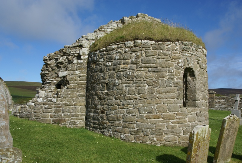
Orphir Round Church

The remains of the Orphir Round Church (or Round Kirk), also St Nicholas's Church, are located in Orphir Parish on the Mainland, Orkney, Scotland. It has...

Nearby Amenities

Located within 500m of 58.915187,-3.18706
Ferry Terminal
Houton Ferry Terminal
Network: Hoy & Flotta
Operator: Orkney ferries
Lat/Long: 58.916893/-3.184296
Seamark Light Character: Iso
Seamark Light Colour: red
Seamark Light Height: 7
Seamark Light Period: 4
Seamark Light Range: 5
Seamark Light Reference: A 3642
Seamark Type: light_minor
Source: US NGA Pub. 114. 2011-05-26.
Lat/Long: 58.91665/-3.1847833
Seamark Information: 103
Seamark Light Category: vertical
Seamark Light Character: F
Seamark Light Colour: red
Seamark Light Height: 5
Seamark Light Multiple: 2
Seamark Light Range: 4
Seamark Light Reference: A 3641
Seamark Type: light_minor
Source: US NGA Pub. 114. 2011-05-26.
Lat/Long: 58.9171667/-3.1851833
Seamark Information: Visible 312° - 320°
Seamark Light Category: upper
Seamark Light Character: F
Seamark Light Colour: green
Seamark Light Height: 16
Seamark Light Reference: A 3640.1
Seamark Light Visibility: part_obscured
Seamark Type: light_minor
Source: US NGA Pub. 114. 2011-05-26.
Lat/Long: 58.9173863/-3.1946054
Seamark Information: Visible 312° - 320°
Seamark Light Category: lower
Seamark Light Character: Fl
Seamark Light Colour: green
Seamark Light Height: 8
Seamark Light Period: 3
Seamark Light Reference: A 3640
Seamark Light Sequence: 1+(2)
Seamark Light Visibility: part_obscured
Seamark Type: light_minor
Source: US NGA Pub. 114. 2011-05-26.
Lat/Long: 58.9161541/-3.1923665
Bay of Houton
Natural: bay
Place: locality
Source Name: OS_OpenData_StreetView
Lat/Long: 58.9150574/-3.1877681
Bicycle Parking
Bicycle Parking: stands
Capacity: 6
Covered: no
Fixme: check capacity
Lat/Long: 58.918524/-3.1850027
Power: pole
Lat/Long: 58.9188321/-3.1902623
Power: pole
Lat/Long: 58.9180691/-3.1835219
Power: pole
Lat/Long: 58.9187822/-3.1833744
Leisure: slipway
Lat/Long: 58.9167481/-3.1821545
Leisure: slipway
Lat/Long: 58.9170665/-3.1830486
The data included in this document is from www.openstreetmap.org. The data is made available under ODbL.

Have you been to Bay of Houton?

Leave your review of Bay of Houton below (or comments, questions and feedback).