Borness Bay

Bay in Kirkcudbrightshire

Scotland

Borness Bay

Meikle Pinnacle It's not easy to discern from the sea which feature is which, but I think Meikle Pinnacle is the conical shaped rock at the left hand side of the picture
Meikle Pinnacle Credit: David R Collin

Borness Bay is a picturesque coastal area situated in the county of Kirkcudbrightshire, Scotland. It is located approximately 4 miles southeast of the town of Kirkcudbright and is nestled between the larger bays of Kirkcudbright Bay and Wigtown Bay. The bay offers stunning panoramic views of the Solway Firth and is a popular destination for nature enthusiasts and outdoor adventurers.

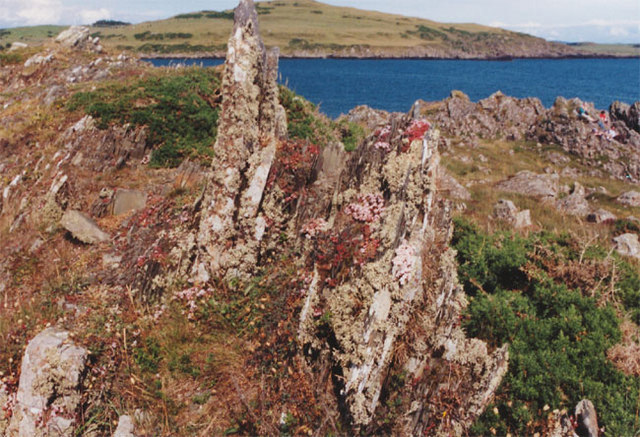
The bay is characterized by its sandy beaches, rocky outcrops, and abundant wildlife. The expansive beach provides ample space for beachcombing, sunbathing, and picnicking, while the surrounding cliffs and rock formations offer opportunities for exploration and birdwatching. The area is home to a variety of bird species, including oystercatchers, curlews, and gulls, making it a haven for birdwatchers.

Borness Bay is also steeped in history and has been inhabited since ancient times. The remains of an Iron Age fort can be found on Little Ross Island, located just off the coast. The bay was also involved in trade and commerce during the medieval period, with Kirkcudbright serving as a prominent trading port.

Today, Borness Bay remains a tranquil and unspoiled coastal gem. It attracts visitors seeking solace and relaxation in its natural beauty. The bay offers a range of activities, including walking, fishing, and kayaking, making it an ideal destination for outdoor enthusiasts. With its stunning scenery, rich history, and diverse wildlife, Borness Bay is a must-visit location for anyone exploring the Kirkcudbrightshire region.

If you have any feedback on the listing, please let us know in the comments section below.

Borness Bay Images

Images are sourced within 2km of 54.784164/-4.1613703 or Grid Reference NX6145. Thanks to Geograph Open Source API. All images are credited.

Meikle Pinnacle It's not easy to discern from the sea which feature is which, but I think Meikle Pinnacle is the conical shaped rock at the left hand side of the picture
Meikle Pinnacle
It's not easy to discern from the sea which feature is which, but I think Meikle Pinnacle is the conical shaped rock at the left hand side of the picture
House forsaken Eighteenth century folk had the energy and the resources to build fine homes like this even in remote places. With a gaudy caravan park less than a mile away, the real essence of rural life stands as a monument to our collective indifference to the efforts of our ancestors.
House forsaken
Eighteenth century folk had the energy and the resources to build fine homes like this even in remote places. With a gaudy caravan park less than a mile away, the real essence of rural life stands as a monument to our collective indifference to the efforts of our ancestors.
The big hoose at Borness, Galloway The daffodils are more advanced here than where I live much farther south than this.
The big hoose at Borness, Galloway
The daffodils are more advanced here than where I live much farther south than this.
Borness Point, Galloway The beautifully green rolling hills of Galloway give way to a very jagged coastline. It's like a beautiful woman with some rough edges and sharp nails
Borness Point, Galloway
The beautifully green rolling hills of Galloway give way to a very jagged coastline. It's like a beautiful woman with some rough edges and sharp nails
Galloway Coast Taken at Borness. The Galloway coastline can look menacing and runs counter to its undulating emerald greenery just behind.
Galloway Coast
Taken at Borness. The Galloway coastline can look menacing and runs counter to its undulating emerald greenery just behind.
Borness Point, Galloway It's a very exciting coastline
Borness Point, Galloway
It's a very exciting coastline
Lichen-covered rocks, Brighouse bay
Whitehill by Cairniehill View up the Borness-Borgue lane just north of Whitehill Cottage.
Whitehill by Cairniehill
View up the Borness-Borgue lane just north of Whitehill Cottage.
Muncraig Hill View View across grazing fields towards Whitehill from the Chapelton Row-Muncraig lane on southern slopes of Muncraig Hill.
Muncraig Hill View
View across grazing fields towards Whitehill from the Chapelton Row-Muncraig lane on southern slopes of Muncraig Hill.
Muncraig Farm Muncraig farmhouse and buildings. Beyond is Muncraig Heugh, an archaeological site of a ditched settlement or homestead abutting on to steep cliffs.
Muncraig Farm
Muncraig farmhouse and buildings. Beyond is Muncraig Heugh, an archaeological site of a ditched settlement or homestead abutting on to steep cliffs.
Meteor Landing STREWTH ! - just stopped in time!
Meteor Landing
STREWTH ! - just stopped in time!
Cairn at Borness Bar Also showing the footpath down to Borness Batteries
Cairn at Borness Bar
Also showing the footpath down to Borness Batteries
Cairn at Borness Bar
Harrison's Bay from Borness Point
Brighouse Bay near Dunrod Point
Borness Point
Borness Point
Rummlekirn Brighouse Bay Caravan Park can be seen in the background
Rummlekirn
Brighouse Bay Caravan Park can be seen in the background
Bone cave of Borness The cave entrance can be seen in the middle of the picture. This cave was inhabited in ancient times and has been the subject of extensive excavation.
Bone cave of Borness
The cave entrance can be seen in the middle of the picture. This cave was inhabited in ancient times and has been the subject of extensive excavation.
Show me another place!

Borness Bay is located at Grid Ref: NX6145 (Lat: 54.784164, Lng: -4.1613703)

Unitary Authority: Dumfries and Galloway

Police Authority: Dumfries and Galloway

What 3 Words

///listen.engaging.circles. Near Kirkcudbright, Dumfries & Galloway

Nearby Locations

Borness Borness Bay

Related Wikis

Borness

Borness is a farm of around 1550 acres on the coast of Borgue Parish in the Stewartry of Kirkcudbrightshire (now part of Dumfries and Galloway). It is...

Kirkandrews, Dumfries and Galloway

Kirkandrews, sometimes written as Kirkanders in older documents, is a coastal hamlet about 9 kilometres (6 mi) west-southwest of Kirkcudbright in Dumfries...

Borgue, Dumfries and Galloway

Borgue (pronounced /ˈbɔrɡ/; Scottish Gaelic: Borgh) is a village and parish in the Stewartry of Kirkcudbright in Dumfries and Galloway, Scotland. It lies...

Borgue Old House

Borgue Old House is a ruined Y-plan house, about 300 metres (0.2 mi) east of Borgue in Dumfries and Galloway, Scotland. Built in 1680, but probably incorporating...

Corseyard Farm

Corseyard Farm, known locally as the Coo Palace and now marketed under that name, is an architecturally unusual dairy farm near Kirkandrews in Scotland...

Islands of Fleet

The Islands of Fleet are a group of small islands in Galloway, Scotland. They are in Fleet Bay, which is part of Wigtown Bay, and is in turn part of the...

Little Ross

Little Ross is a 29-acre (12-hectare) island with a lighthouse on the Solway Coast south of the town of Kirkcudbright in Galloway, Scotland. It is next...

Plunton Castle

Plunton Castle is a ruined L-plan tower house between Kirkandrews and Gatehouse of Fleet in Dumfries and Galloway, Scotland. Built around 1575 for the...

Related Videos

Camping At Brighouse Bay

Camping with the family at Brighouse Bay 6/7/2019.

Brighouse Circuit Walk

A stunning coastal walk that starts at Brighhouse Bay and follows the coastline through a beautiful wooded area and up onto the ...

Bongo campervan trip to Kirkudbright

First Bongo trip since our house move. Brighouse bay holiday park, Kirkcudbright.

Nearby Amenities

Located within 500m of 54.784164,-4.1613703
Source: Landsat photo
Lat/Long: 54.7874843/-4.1635501
Source: Landsat photo
Lat/Long: 54.7866164/-4.162062
Source: Landsat photo
Lat/Long: 54.7856018/-4.161738
Source: Landsat photo
Lat/Long: 54.7856407/-4.1614258
Source: Landsat photo
Lat/Long: 54.7812418/-4.1594281
Source: Landsat photo
Lat/Long: 54.7807004/-4.1594871
Source: Landsat photo
Lat/Long: 54.7802908/-4.1592683
Ringadoo Bay
Natural: bay
Lat/Long: 54.7871639/-4.1653644
The data included in this document is from www.openstreetmap.org. The data is made available under ODbL.

Have you been to Borness Bay?

Leave your review of Borness Bay below (or comments, questions and feedback).