Camas Beag

Bay in Argyllshire

Scotland

Camas Beag

Sallachan Point Sallachan Point encloses a sheltered shallow bay. The ridge of modest Beinn Leamhain, a mere 508 metres in height, dominates the view.
Sallachan Point Credit: Anne Burgess

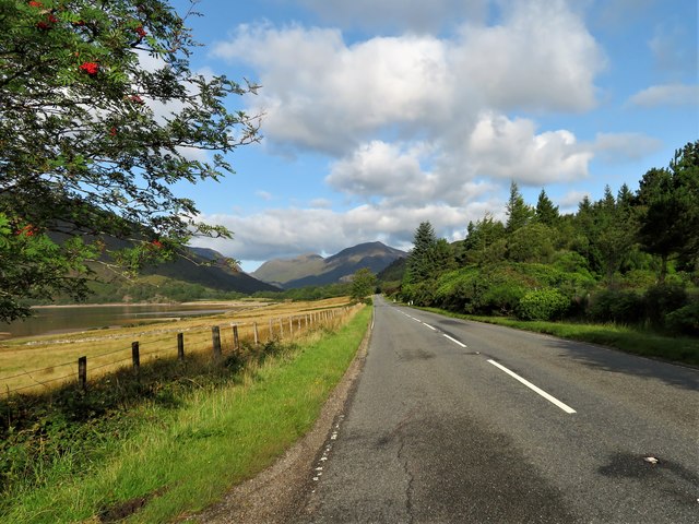
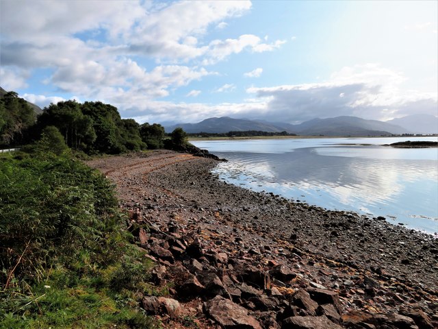
Camas Beag is a picturesque bay located in the region of Argyllshire on the western coast of Scotland. Nestled between rolling hills and facing the Atlantic Ocean, this bay offers breathtaking views and a tranquil atmosphere. The name "Camas Beag" translates to "small bay" in Gaelic, accurately describing its size compared to other bays in the area.

The bay is known for its unspoiled natural beauty, with golden sandy beaches and crystal-clear turquoise waters. The surrounding landscape consists of lush green meadows, rocky cliffs, and scattered wildflowers, creating a postcard-worthy setting. It is not uncommon to spot various marine wildlife in the bay, including seals, dolphins, and even the occasional whale.

For outdoor enthusiasts, Camas Beag provides ample opportunities for exploration and recreation. The bay is a popular spot for swimming, kayaking, and paddleboarding due to its calm waters. There are also several walking trails that wind through the nearby hills, offering stunning views of the bay and the surrounding countryside.

Although secluded, Camas Beag is not entirely remote. The small village of Argyllshire is just a short distance away, providing basic amenities and services. Visitors can find cozy accommodations, local shops selling souvenirs and traditional Scottish products, as well as restaurants serving fresh seafood caught in the nearby waters.

Overall, Camas Beag is a hidden gem in Argyllshire, offering a peaceful and picturesque escape for those seeking a true Scottish coastal experience.

If you have any feedback on the listing, please let us know in the comments section below.

Camas Beag Images

Images are sourced within 2km of 56.711494/-5.3008576 or Grid Reference NM9862. Thanks to Geograph Open Source API. All images are credited.

Sallachan Point Sallachan Point encloses a sheltered shallow bay. The ridge of modest Beinn Leamhain, a mere 508 metres in height, dominates the view.
Sallachan Point
Sallachan Point encloses a sheltered shallow bay. The ridge of modest Beinn Leamhain, a mere 508 metres in height, dominates the view.
Sgeirean Shallachain Three small islands in Loch Linnhe.
Sgeirean Shallachain
Three small islands in Loch Linnhe.
Shore of Loch Linnhe The northern most of the three small islands that comprise Sgeirean Shallachain is on the right.
Shore of Loch Linnhe
The northern most of the three small islands that comprise Sgeirean Shallachain is on the right.
Rocks beside the A861
Crofts of Sallachan Some houses and a telecommunications tower.
Crofts of Sallachan
Some houses and a telecommunications tower.
Sgeirean Shallachain Glencoe well beyond.
Sgeirean Shallachain
Glencoe well beyond.
Fishing weir An interesting feature of the eastern end of the sandy beach at Sallachan is this well-preserved fishing weir, which is clearly visible on satellite imagery. Such structures are well-known and have been dated as far back as the Neolithic period, but I can find no mention of this example.
Fishing weir
An interesting feature of the eastern end of the sandy beach at Sallachan is this well-preserved fishing weir, which is clearly visible on satellite imagery. Such structures are well-known and have been dated as far back as the Neolithic period, but I can find no mention of this example.
Half-tide at Sallachan Water is ebbing slowly from the level, sandy beach. Beaches like this are very rare in the area, being mostly steep and stony, so my Geograph assistant is in his element.
Half-tide at Sallachan
Water is ebbing slowly from the level, sandy beach. Beaches like this are very rare in the area, being mostly steep and stony, so my Geograph assistant is in his element.
Sgeirean Shallachain At high water with hauled out seals.
Sgeirean Shallachain
At high water with hauled out seals.
Down to the Sea If not directly to the sea this trackway at least leads to foreshore fields by Camas Sallachan.
Down to the Sea
If not directly to the sea this trackway at least leads to foreshore fields by Camas Sallachan.
Camas Sallachan The foreshore at Camas Sallachan with Sallachan Point beyond.
Camas Sallachan
The foreshore at Camas Sallachan with Sallachan Point beyond.
West Along Camus Sallachan Rough grazing above the shoreline at Camus Sallachan with Beinn Leamhain behind.
West Along Camus Sallachan
Rough grazing above the shoreline at Camus Sallachan with Beinn Leamhain behind.
A861 West by Sallachan The A861 leading toward Strontian with Camas Sallachan on the left.
A861 West by Sallachan
The A861 leading toward Strontian with Camas Sallachan on the left.
Camas na Craoibhe The bay of the branches, Camus na Craoibhe close to its larger neighbour Camus Shallachain.
Camas na Craoibhe
The bay of the branches, Camus na Craoibhe close to its larger neighbour Camus Shallachain.
Sgeirean Shallachain Three offshore skerries and a view over Loch Linnhe.
Sgeirean Shallachain
Three offshore skerries and a view over Loch Linnhe.
Roadside Quarry A disused quarry by the A861 being used to store aggregate.
Roadside Quarry
A disused quarry by the A861 being used to store aggregate.
Old Milestone by the A861, Camas Shallachan, Ardgour Parish Highland granite by the A861, in parish of Ardgour (Lochaber District), Camas Shallachan, East side of loch.

Surveyed

Milestone Society National ID: HI_CFSA02
Old Milestone by the A861, Camas Shallachan, Ardgour Parish
Highland granite by the A861, in parish of Ardgour (Lochaber District), Camas Shallachan, East side of loch. Surveyed Milestone Society National ID: HI_CFSA02
Old Milestone by the A861, Camas Shallachan, Ardgour parish Highland granite by the A861, in parish of Ardgour (Lochaber District), Camas Shallachain, West side of loch.

Inscription not recorded.

Surveyed

Milestone Society National ID: HI_CFSA03
Old Milestone by the A861, Camas Shallachan, Ardgour parish
Highland granite by the A861, in parish of Ardgour (Lochaber District), Camas Shallachain, West side of loch. Inscription not recorded. Surveyed Milestone Society National ID: HI_CFSA03
Show me another place!

Camas Beag is located at Grid Ref: NM9862 (Lat: 56.711494, Lng: -5.3008576)

Unitary Authority: Highland

Police Authority: Highlands and Islands

What 3 Words

///scout.cluttered.madness. Near Glencoe, Highland

Related Wikis

Loch Linnhe

Loch Linnhe ( lokh LIN-ee) is a sea loch on the west coast of Scotland. The part upstream of Corran is known in Gaelic as An Linne Dhubh (the black pool...

Corran, Lochaber

Corran (Scottish Gaelic: An Corran) is a former fishing village, situated on Corran Point, on the west side of the Corran Narrows of Loch Linnhe, in Lochaber...

Corran Ferry

The Corran Ferry crosses Loch Linnhe at the Corran Narrows, south of Fort William, Scotland. == Description == Operated by Highland Council, the Corran...

Ardgour

Ardgour ( ) (Scottish Gaelic: Àird Ghobhar [aːrˠʃtʲ ˈɣo.əɾ]; meaning high place of goats) is an area of the Scottish Highlands on the western shore of...

Onich

Onich (; Gaelic: Omhanaich, 'abounding in froth, frothy place'), also spelled Ounich, is a village in the historic county of Inverness-shire on the east...

Inchree

Inchree (Scottish Gaelic: Innis an Ruighe) is a small hamlet, situated at the northern end of the village of Onich. It is 7 miles south of the town of...

Kentallen railway station

Kentallen was a railway station at the head of Kentallen Bay, which is on the southern shore of Loch Linnhe in the Highland council area of Scotland. It...
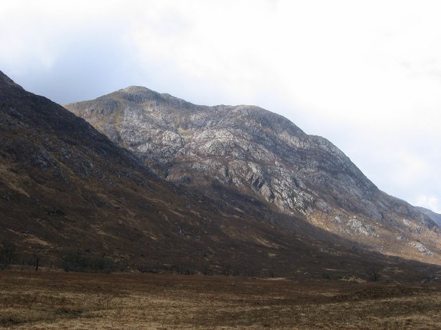
Beinn Bheag

Beinn Bheag (736 m) is a mountain in the Northwest Highlands of Scotland. It lies in the Ardgour area of Lochaber, west of the village of Corran. The peak...

Nearby Amenities

Located within 500m of 56.711494,-5.3008576
Parking
Lat/Long: 56.7132124/-5.2973038
Power: pole
Lat/Long: 56.7156546/-5.2997848
Power: pole
Lat/Long: 56.7157252/-5.3016436
Power: pole
Lat/Long: 56.7159092/-5.2996261
Power: pole
Lat/Long: 56.71579/-5.3029928
Power: pole
Lat/Long: 56.7143504/-5.3025824
Power: pole
Lat/Long: 56.7142591/-5.3012037
Power: pole
Lat/Long: 56.714162/-5.2999029
Power: pole
Lat/Long: 56.7139677/-5.2972126
Power: pole
Lat/Long: 56.7137822/-5.2962551
Power: pole
Lat/Long: 56.7132905/-5.2937338
Sallachan
Name Gd: Salachan
Place: hamlet
Lat/Long: 56.7134267/-5.295608
The data included in this document is from www.openstreetmap.org. The data is made available under ODbL.

Have you been to Camas Beag?

Leave your review of Camas Beag below (or comments, questions and feedback).