Flimston Bay
Bay in Pembrokeshire
Wales
Flimston Bay

Flimston Bay is a captivating, picturesque bay located on the southern coast of Pembrokeshire, Wales. Nestled between the renowned Barafundle Bay and the charming village of Stackpole, this secluded gem offers visitors an idyllic natural setting away from the hustle and bustle of modern life.
The bay boasts a stunning, golden sandy beach that stretches for approximately half a mile, providing ample space for relaxation and sunbathing. The crystal-clear waters are perfect for swimming and snorkeling, and during low tide, visitors can explore fascinating rock pools teeming with marine life. The bay is also a popular spot for kayaking and paddleboarding, attracting outdoor enthusiasts seeking adventure.
Flimston Bay is situated within the Stackpole Estate, which is managed by the National Trust. The estate encompasses a diverse range of habitats, including woodlands, lakes, and dunes, making it a haven for wildlife. Visitors can embark on scenic walks along the coastal path, taking in breathtaking views of the bay and the dramatic limestone cliffs that surround it. The area is home to a variety of bird species, such as puffins, razorbills, and guillemots, making it a haven for birdwatchers.
Access to Flimston Bay is via a footpath from Stackpole Quay or from the nearby Barafundle Bay. Due to its secluded location, the bay offers a sense of tranquility and solitude, allowing visitors to immerse themselves in the natural beauty of the Pembrokeshire coastline. With its pristine beach, stunning scenery, and abundant wildlife, Flimston Bay is a must-visit destination for nature lovers and those seeking a peaceful escape.
If you have any feedback on the listing, please let us know in the comments section below.
Flimston Bay Images
Images are sourced within 2km of 51.61097/-4.9875062 or Grid Reference SR9394. Thanks to Geograph Open Source API. All images are credited.


Flimston Bay is located at Grid Ref: SR9394 (Lat: 51.61097, Lng: -4.9875062)
Unitary Authority: Pembrokeshire
Police Authority: Dyfed Powys
What 3 Words
///eggshell.pickup.shock. Near Bosherston, Pembrokeshire
Nearby Locations
Related Wikis
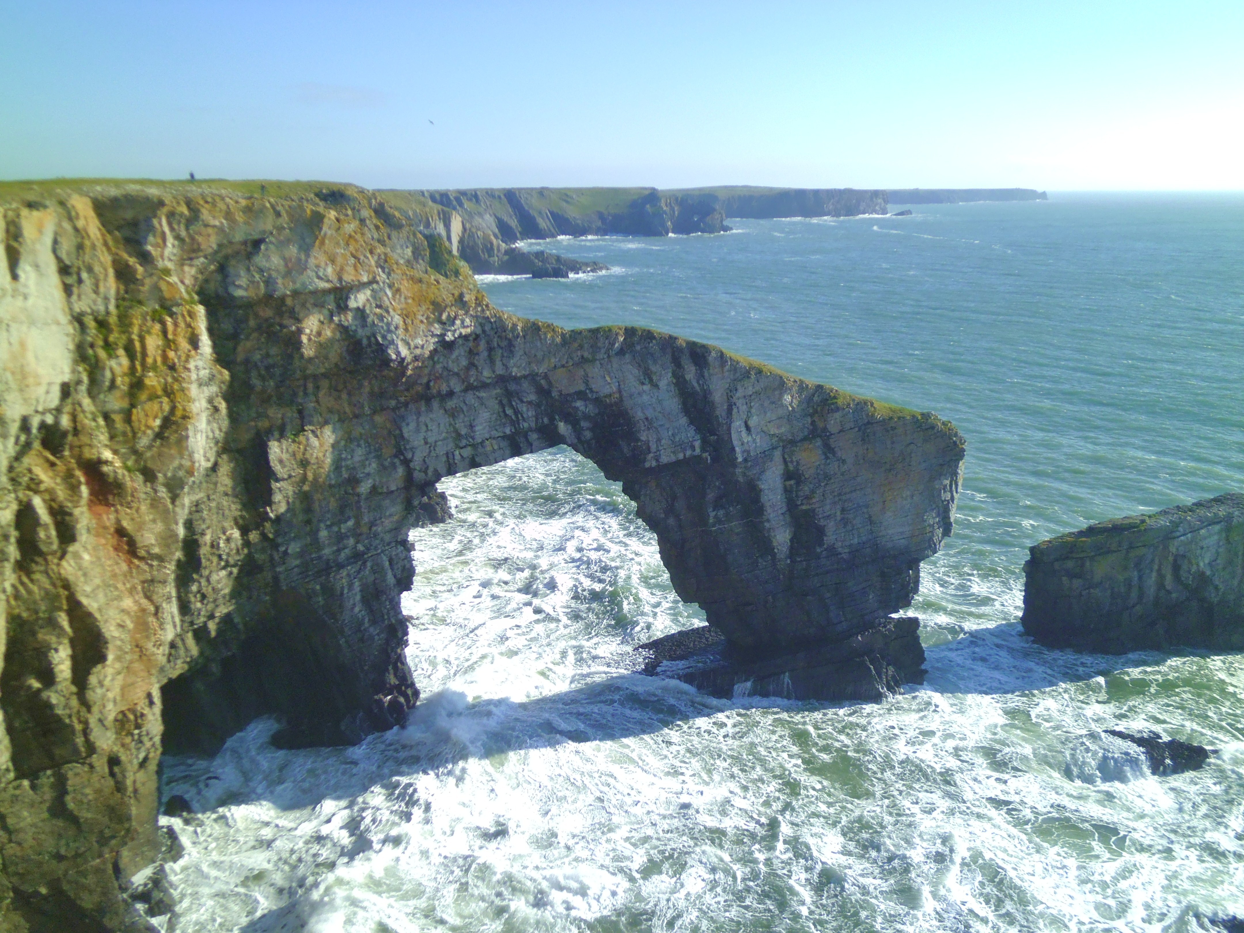
Green Bridge of Wales
The Green Bridge of Wales (Welsh: Pont Werdd Cymru) is a natural arch formed from Carboniferous Limestone within the Pembrokeshire Coast National Park...

Castlemartin Training Area
Castlemartin Training Area is a British Army military training area and armoured fighting vehicle range located in the Welsh county of Pembrokeshire. It...

Stackpole and Castlemartin
Stackpole and Castlemartin is a community in Pembrokeshire, Wales, 4 miles (6.4 km) south of Pembroke.It was formed in 2011 by the amalgamation of the...

Warren, Pembrokeshire
Warren is an ancient parish in the community of Stackpole and Castlemartin, in the most southerly part of Pembrokeshire, Wales. Its northern edge is 5...
Nearby Amenities
Located within 500m of 51.61097,-4.9875062Have you been to Flimston Bay?
Leave your review of Flimston Bay below (or comments, questions and feedback).