Inninmore Bay

Bay in Argyllshire

Scotland

Inninmore Bay

Inninmore Bay Navigation Buoy viewed from the MV Isle of Lewis
Inninmore Bay Navigation Buoy viewed from the MV Isle of Lewis Credit: Peter Moore

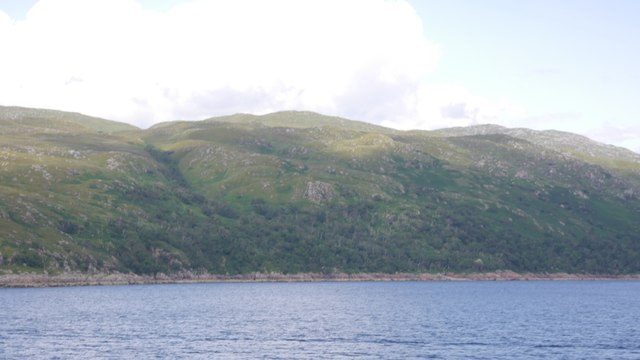
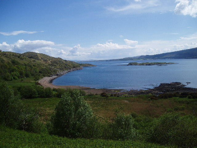
Inninmore Bay is a picturesque bay located in the region of Argyllshire, Scotland. Situated along the western coast of Scotland, this bay offers stunning panoramic views of the surrounding landscapes and the vast expanse of the Atlantic Ocean.

The bay is known for its tranquil and serene atmosphere, making it a popular destination for both locals and tourists seeking a peaceful retreat. The bay is surrounded by rolling hills and lush greenery, creating a beautiful natural backdrop for visitors to enjoy.

The waters of Inninmore Bay are crystal clear and are home to a diverse range of marine life. It is a haven for nature enthusiasts and bird watchers, with numerous species of birds making their homes in the surrounding areas. Seals and dolphins can also be spotted swimming in the bay, adding to its allure.

For those interested in outdoor activities, Inninmore Bay offers a range of options. The bay is ideal for kayaking, canoeing, and sailing, with calm waters providing a safe environment for water sports enthusiasts. The surrounding hills and trails also offer ample opportunities for hiking and exploring the area's natural beauty.

Inninmore Bay is also close to several charming villages and towns, where visitors can discover local culture and sample traditional Scottish cuisine. Its convenient location makes it a great starting point for exploring the wider Argyllshire region and all it has to offer.

Overall, Inninmore Bay is a hidden gem in Argyllshire, offering a tranquil escape in a stunning natural setting. Its breathtaking views, diverse wildlife, and range of outdoor activities make it a must-visit destination for nature lovers and adventure seekers alike.

If you have any feedback on the listing, please let us know in the comments section below.

Inninmore Bay Images

Images are sourced within 2km of 56.509579/-5.7031292 or Grid Reference NM7241. Thanks to Geograph Open Source API. All images are credited.

Inninmore Bay Navigation Buoy viewed from the MV Isle of Lewis
Rubha an Ridire, Kingairloch The southern tip of Kingairloch, at the junction of the Sound of Mull and Loch Linnhe. The small loch is Lochan Màm a' Chullaichs, and the one at upper right is Loch Tearnait.
Rubha an Ridire, Kingairloch
The southern tip of Kingairloch, at the junction of the Sound of Mull and Loch Linnhe. The small loch is Lochan Màm a' Chullaichs, and the one at upper right is Loch Tearnait.
Eilean Rubha an Ridire
Navigation buoy, Sound of Mull Off Inninmore Bay.
Navigation buoy, Sound of Mull
Off Inninmore Bay.
Aoineadh Mòr A basalt crag on the coast of Morvern. There is a fine oakwood on this shore as well as around the corner on Loch Linnhe.
Aoineadh Mòr
A basalt crag on the coast of Morvern. There is a fine oakwood on this shore as well as around the corner on Loch Linnhe.
Crags above Rubha an t-Sasannaich The Morvern coast on the Sound of Mull.  There are some impressive basalt crags here.
Crags above Rubha an t-Sasannaich
The Morvern coast on the Sound of Mull. There are some impressive basalt crags here.
Isle of Lewis, Inninmore Bay Barra bound ferry in the Sound of Mull.
Isle of Lewis, Inninmore Bay
Barra bound ferry in the Sound of Mull.
Glas Eileanan Skerries in the Sound of Mull with Dùn da Ghaoithe beyond.
Glas Eileanan
Skerries in the Sound of Mull with Dùn da Ghaoithe beyond.
Eilean Rubha an Ridire A flat island off Morvern at the mouth of the Sound of Mull.
Eilean Rubha an Ridire
A flat island off Morvern at the mouth of the Sound of Mull.
Eilean Rubha an Ridire A flat island with a tidal channel through it. It is situated at the rough southeast end of Morvern.
Eilean Rubha an Ridire
A flat island with a tidal channel through it. It is situated at the rough southeast end of Morvern.
Eilean Rubha an Ridire Eilean Rubha an Ridire a pair of flat islands with a tidal channel through them at the mouth of the Sound of Mull.  The wooded hillside at Inninmore forms the background. The gully is where Tertiary basalts meet the older gneisses which make this corner of Morvern so rugged looking.
Eilean Rubha an Ridire
Eilean Rubha an Ridire a pair of flat islands with a tidal channel through them at the mouth of the Sound of Mull. The wooded hillside at Inninmore forms the background. The gully is where Tertiary basalts meet the older gneisses which make this corner of Morvern so rugged looking.
Rubha an Ridire, Morvern Rugged gneiss hills (good hillwalking here) above oakwoods at Morvern's southern tip.
Rubha an Ridire, Morvern
Rugged gneiss hills (good hillwalking here) above oakwoods at Morvern's southern tip.
Rubha an Ridire The southernmost tip of Morvern at the east end of the Sound of Mull
Rubha an Ridire
The southernmost tip of Morvern at the east end of the Sound of Mull
Light Beacon on Glas Eileanan
Eilean Rubha an Ridire Low rocky island close to the eastern entrance to the Sound of Mull. The mainland is in the background.
Eilean Rubha an Ridire
Low rocky island close to the eastern entrance to the Sound of Mull. The mainland is in the background.
Dearg Allt, Inninmore
Beach at Inninmore
Beach at Inninmore
Rubha an t- Sasannaich looking towards Inninmore Bay
Show me another place!

Inninmore Bay is located at Grid Ref: NM7241 (Lat: 56.509579, Lng: -5.7031292)

Unitary Authority: Highland

Police Authority: Highlands and Islands

What 3 Words

///acrobats.amber.clap. Near Craignure, Argyll & Bute

Nearby Locations

Inninmore Bay

Related Wikis

Inninmore Bay

Inninmore Bay is a small shallow coastal embayment, on a chord of 1.74 miles, on a 215° orientation, in the Morvern peninsula in Lochaber, in the western...

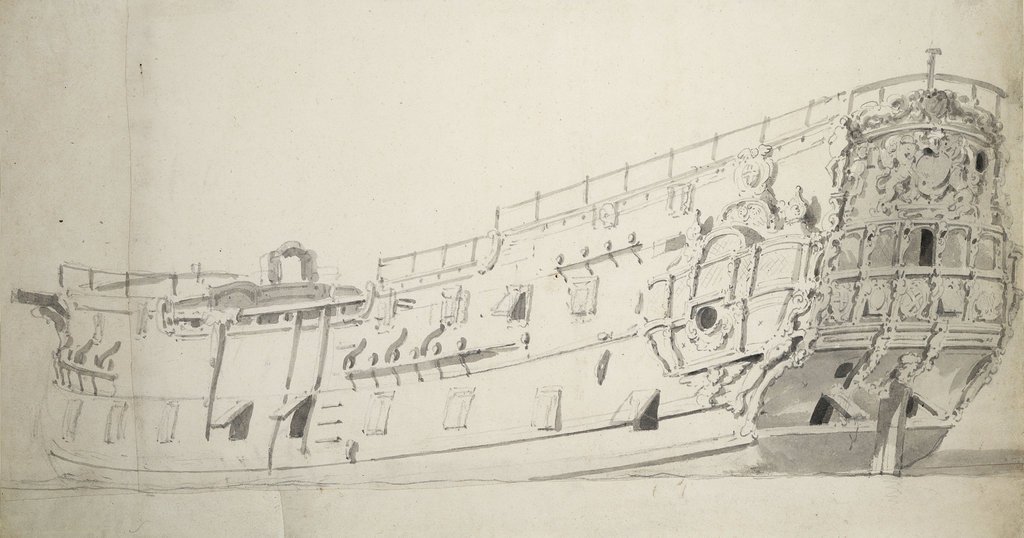
HMS Dartmouth (1655)

HMS Dartmouth was a small frigate or fifth-rate ship, one of six ordered by the English Council of State on 28 December 1654, and built in 1655. ��2�...

SS Thesis

SS Thesis was a steamship which was wrecked in October 1889 in the Sound of Mull, on Scotland's west coast. She is now a popular dive site with scuba...

Ardtornish Bay

Ardtornish Bay is coastal embayment, on a chord of 0.89 miles, on a 161° orientation, in the Morvern peninsula in Lochaber, in the western coast of Scotland...

Nearby Amenities

Located within 500m of 56.509579,-5.7031292
Inninmore Bay
Natural: bay
Lat/Long: 56.5097388/-5.7037068
The data included in this document is from www.openstreetmap.org. The data is made available under ODbL.

Have you been to Inninmore Bay?

Leave your review of Inninmore Bay below (or comments, questions and feedback).