Lòn Reudle

Bay in Argyllshire

Scotland

Lòn Reudle

Roadside Cairn A cairn beside the B8073 with Loch Tuath in the far distance.
Roadside Cairn Credit: Andrew Wood

The requested URL returned error: 429 Too Many Requests

If you have any feedback on the listing, please let us know in the comments section below.

Lòn Reudle Images

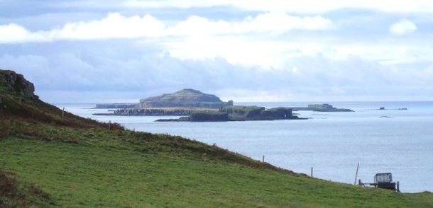
Images are sourced within 2km of 56.526728/-6.2992418 or Grid Reference NM3545. Thanks to Geograph Open Source API. All images are credited.
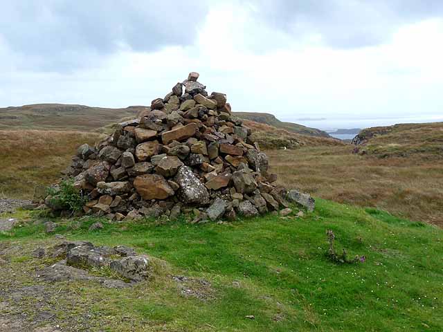
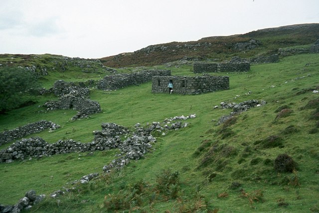
Roadside Cairn A cairn beside the B8073 with Loch Tuath in the far distance.
Roadside Cairn
A cairn beside the B8073 with Loch Tuath in the far distance.
Crackaig A deserted settlement comprising about 15 unroofed buildings and other enclosures. Crackaig, along with the nearby deserted settlement of Glac Gugairidh, is a scheduled monument (SM10577).

A dwelling house at the eastern end of the settlement has ship graffiti carved on the outside wall. Local tradition has it that this was carved by one of the last inhabitants and represents the ship that was to take the people away across the Atlantic to their new home in America. A single-roomed structure 175m to the SSE of the main cluster of buildings at Crackaig is said to be the schoolhouse.
<span class="nowrap"><a title="https://ancientmonuments.uk/123755-crackaig-and-glac-gugairidh-depopulated-settlements-mull-oban-south-and-the-isles-ward" rel="nofollow ugc noopener" href="https://ancientmonuments.uk/123755-crackaig-and-glac-gugairidh-depopulated-settlements-mull-oban-south-and-the-isles-ward">Link</a><img style="margin-left:2px;" alt="External link" title="External link - shift click to open in new window" src="https://s1.geograph.org.uk/img/external.png" width="10" height="10"/></span>

According to a local blog about the old ash tree at Crackaig: "Crackaig and Glac Gugairigh were abandoned, not because of the Highland clearances but following a typhoid epidemic in the late 19th century when the disease almost wiped out the populations of both villages. It is rumoured that the last remaining resident refused to leave his home and hanged himself from the only tree in the area."
<span class="nowrap"><a title="https://www.mullnativewoodlandsgroup.co.uk/2018/05/the-old-ash-tree-of-crackaig/" rel="nofollow ugc noopener" href="https://www.mullnativewoodlandsgroup.co.uk/2018/05/the-old-ash-tree-of-crackaig/">Link</a><img style="margin-left:2px;" alt="External link" title="External link - shift click to open in new window" src="https://s1.geograph.org.uk/img/external.png" width="10" height="10"/></span>
Crackaig
A deserted settlement comprising about 15 unroofed buildings and other enclosures. Crackaig, along with the nearby deserted settlement of Glac Gugairidh, is a scheduled monument (SM10577). A dwelling house at the eastern end of the settlement has ship graffiti carved on the outside wall. Local tradition has it that this was carved by one of the last inhabitants and represents the ship that was to take the people away across the Atlantic to their new home in America. A single-roomed structure 175m to the SSE of the main cluster of buildings at Crackaig is said to be the schoolhouse. LinkExternal link According to a local blog about the old ash tree at Crackaig: "Crackaig and Glac Gugairigh were abandoned, not because of the Highland clearances but following a typhoid epidemic in the late 19th century when the disease almost wiped out the populations of both villages. It is rumoured that the last remaining resident refused to leave his home and hanged himself from the only tree in the area." LinkExternal link
Looking down on Crackaig
Walking the dog at Reudle Looking over to Ulva Island.
Walking the dog at Reudle
Looking over to Ulva Island.
View towards Ben More from Cnoc an t-Sluaigh
Coastline of Loch Tuath near Dun Aisgain The circular pool in the rocks at the sea edge is prominent in the aerial imagery provided by OS Maps.
Coastline of Loch Tuath near Dun Aisgain
The circular pool in the rocks at the sea edge is prominent in the aerial imagery provided by OS Maps.
Crackaig seen from the sea Trap landscape, Treshnish.
Crackaig seen from the sea
Trap landscape, Treshnish.
Cairn by the B8073 This cairn marks the highest point of the B8073 road as it crosses the neck of the peninsula separating Calgary Bay and Loch Tuath. Out to sea can be seen Eilean Dioghlum <a href="https://www.geograph.org.uk/gridref/NM3442">NM3442</a> with Staffa <a href="https://www.geograph.org.uk/gridref/NM3235">NM3235</a> beyond.
Cairn by the B8073
This cairn marks the highest point of the B8073 road as it crosses the neck of the peninsula separating Calgary Bay and Loch Tuath. Out to sea can be seen Eilean Dioghlum NM3442 with Staffa NM3235 beyond.
Approaching Glac Gugairidh Sheep on the path at the approach to the ruined settlement of Glac Gugairidh.
Approaching Glac Gugairidh
Sheep on the path at the approach to the ruined settlement of Glac Gugairidh.
Ruins at Glac Gugairidh Abandoned [or possibly cleared] in the 19th century, this settlement consisted of thatched croft cottages with evidence of runrig agriculture around. The Gaelic name means 'the hollow of the dark grazings'.
Ruins at Glac Gugairidh
Abandoned [or possibly cleared] in the 19th century, this settlement consisted of thatched croft cottages with evidence of runrig agriculture around. The Gaelic name means 'the hollow of the dark grazings'.
Ruins at Crackaig The lower of the two settlements on the moorland above a cliffed coastline. It is probably 150 years since these crofts were inhabited.
Ruins at Crackaig
The lower of the two settlements on the moorland above a cliffed coastline. It is probably 150 years since these crofts were inhabited.
Clifftop sheep Blackface ewe on the cliffs at Crackaig. The view is along Loch Tuath towards snow covered Ben More.
Clifftop sheep
Blackface ewe on the cliffs at Crackaig. The view is along Loch Tuath towards snow covered Ben More.
The rough rocky coast at Treshnish Ben More and its outlying tops dominate the skyline
The rough rocky coast at Treshnish
Ben More and its outlying tops dominate the skyline
Settlement ruins at Crackaig
Cairn above Burg Top of the pass over Treshnish - view towards Ben More.
Cairn above Burg
Top of the pass over Treshnish - view towards Ben More.
Pass, Treshnish Highest point of the road over Treshnish between Kilninian and Calgary.
Pass, Treshnish
Highest point of the road over Treshnish between Kilninian and Calgary.
Moorland, Treshnish Above the Kilninian to Calgary road. It took a short rough climb to get into the grid square.
Moorland, Treshnish
Above the Kilninian to Calgary road. It took a short rough climb to get into the grid square.
Sharp bend in the B8073
Show me another place!

Lòn Reudle is located at Grid Ref: NM3545 (Lat: 56.526728, Lng: -6.2992418)

Unitary Authority: Argyll and Bute

Police Authority: Argyll and West Dunbartonshire

What 3 Words

///evenings.forensic.swooned. Near Calgary, Argyll & Bute

Nearby Locations

Lòn Reudle

Related Wikis

Gometra

Gometra (Scottish Gaelic: Gòmastra) is an island in the Inner Hebrides of Scotland, lying west of Mull. It lies immediately west of Ulva, to which it is...

Cairn na Burgh Beag

Cairn na Burgh Beag is one of the Treshnish Isles in the Inner Hebrides, Scotland. Cairn na Burgh Beag is the smaller of the two "Carnburgs" (as they...

Cairnburgh Castle

Cairnburgh Castle is a ruined castle that is located on the islands of Cairn na Burgh Mòr and Cairn na Burgh Beag, Argyll and Bute, Scotland. These islands...

Cairn na Burgh Mòr

Cairn na Burgh Mòr (also Cairnburgh More) is one of the Treshnish Isles in the Inner Hebrides of Scotland. Cairn na Burgh Mòr is the larger of the two...

Have you been to Lòn Reudle?

Leave your review of Lòn Reudle below (or comments, questions and feedback).