Tòb a' Mhorghain

Bay in Ross-shire

Scotland

Tòb a' Mhorghain

Crystal clear seas off North West coast of Na h-Eileanan an Iar View to about 3 metres depth from RIB floating in lagoon between Pabaigh Mor and Pabaigh Beag.  See also <a href="https://www.geograph.org.uk/photo/1120209">NB1038 : Lagoon on Pabbay Mor</a>
Crystal clear seas off North West coast of Na h-Eileanan an Iar Credit: Hazel Hambidge

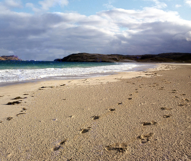
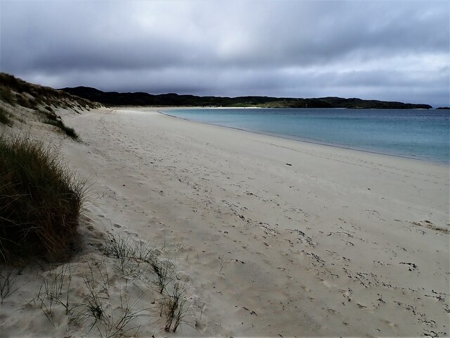
Tòb a' Mhorghain is a picturesque bay located in Ross-shire, a county in the Highland region of Scotland. Situated on the northwest coast of the country, the bay offers stunning views of the rugged coastline and the vast expanse of the North Atlantic Ocean.

The bay is characterized by its pristine sandy beach, which stretches for approximately 1.5 miles. The soft golden sand is complemented by clear turquoise waters, creating an idyllic setting for beachgoers and nature enthusiasts alike. The bay is also surrounded by rolling green hills and dramatic cliffs, adding to its natural beauty.

Tòb a' Mhorghain is a popular destination for various outdoor activities. The beach provides ample opportunities for swimming, sunbathing, and picnicking. Additionally, the bay is known for its excellent conditions for water sports such as kayaking, windsurfing, and paddleboarding. The surrounding hills and cliffs offer fantastic hiking trails, allowing visitors to explore the breathtaking coastal scenery and observe the diverse wildlife in the area.

The bay is also home to a rich marine ecosystem, making it a haven for birdwatchers and nature lovers. Seals and dolphins can often be spotted in the waters, and the bay is a designated Special Protection Area for bird species such as the black-throated diver and the great northern diver.

Tòb a' Mhorghain is not only a natural gem but also a place of tranquility and serenity, attracting visitors from all over the world who seek to immerse themselves in the beauty of the Scottish coast.

If you have any feedback on the listing, please let us know in the comments section below.

Tòb a' Mhorghain Images

Images are sourced within 2km of 58.230061/-6.9181845 or Grid Reference NB1137. Thanks to Geograph Open Source API. All images are credited.

Crystal clear seas off North West coast of Na h-Eileanan an Iar View to about 3 metres depth from RIB floating in lagoon between Pabaigh Mor and Pabaigh Beag.  See also <a href="https://www.geograph.org.uk/photo/1120209">NB1038 : Lagoon on Pabbay Mor</a>
Crystal clear seas off North West coast of Na h-Eileanan an Iar
View to about 3 metres depth from RIB floating in lagoon between Pabaigh Mor and Pabaigh Beag. See also NB1038 : Lagoon on Pabbay Mor
Berie Sands Caravan Park Busy site at Traigh na Beirigh with many caravans parked on the machair above the extensive sands.
Berie Sands Caravan Park
Busy site at Traigh na Beirigh with many caravans parked on the machair above the extensive sands.
Tràigh na Beirigh In the 1960's this was a deserted beach.  Now it has to be shared with caravanners.
Tràigh na Beirigh
In the 1960's this was a deserted beach. Now it has to be shared with caravanners.
Tràigh na Beirigh A perfect crescent beach
Tràigh na Beirigh
A perfect crescent beach
A rocky buttress contains Tràigh na Beirigh
Traigh na Berie
Traigh na Berie
Tràigh na Beirigh from the east
Sunrise, Gridig
Sunrise, Gridig
Tràigh Teinish
Tràigh Teinish
Beach at Pabaigh Mor
Geodh'an Tuill penetrates Pabaigh Mor Pabaigh More has a tidally flooded low-lying area in the middle of the island (at one time used for buffering lobsters) which connects to the open sea over a reef to the northwest, and through a couple of rocky channels heading northeast. It's clear that those channels must have started the same way as this cave, which has penetrated right to the lagoon (from which it is separated only by a storm beach thrown up by waves entering the cave) and, on a geological timescale, is just about at the end of its life. Although one of our group walked over the arch, and once we'd paddled round the island several of us entered the cave from the sea, it is not the most confidence-inspiring roof, especially at this landward end.
Geodh'an Tuill penetrates Pabaigh Mor
Pabaigh More has a tidally flooded low-lying area in the middle of the island (at one time used for buffering lobsters) which connects to the open sea over a reef to the northwest, and through a couple of rocky channels heading northeast. It's clear that those channels must have started the same way as this cave, which has penetrated right to the lagoon (from which it is separated only by a storm beach thrown up by waves entering the cave) and, on a geological timescale, is just about at the end of its life. Although one of our group walked over the arch, and once we'd paddled round the island several of us entered the cave from the sea, it is not the most confidence-inspiring roof, especially at this landward end.
Traigh na Berie
Traigh na Berie
Tràigh na Beirigh and Pabaigh Mòr
Tràigh na Beirigh
Tràigh na Beirigh
Traigh na Beirigh beach Lewis Looking out from the beach just in front of the Caravan site towards the headland at Kneep on the left and Pabaigh Mor on the right.
Traigh na Beirigh beach Lewis
Looking out from the beach just in front of the Caravan site towards the headland at Kneep on the left and Pabaigh Mor on the right.
Traigh na Beirigh beach Lewis Looking down the length of the beach towards Kneep.
Traigh na Beirigh beach Lewis
Looking down the length of the beach towards Kneep.
Valtos Pier Sheltering the small harbour of Valtos / Bhaltos on Pabbay Sound / Caolas Phabaigh. The island of Pabaigh Mor / Big Pabbay is in the background.
Valtos Pier
Sheltering the small harbour of Valtos / Bhaltos on Pabbay Sound / Caolas Phabaigh. The island of Pabaigh Mor / Big Pabbay is in the background.
Show me another place!

Tòb a' Mhorghain is located at Grid Ref: NB1137 (Lat: 58.230061, Lng: -6.9181845)

Unitary Authority: Na h-Eileanan an Iar

Police Authority: Highlands and Islands

What 3 Words

///churn.sidelined.correctly. Near Carloway, Na h-Eileanan Siar

Related Wikis

Vacsay

Vacsay (Scottish Gaelic: Bhacsaigh from Old Norse "bakkiey" meaning "peat bank island") is one of the Outer Hebrides. It is off the west coast of Lewis...

Pabaigh Mòr

Pabay Mòr or Pabaigh Mòr is an uninhabited island in the Outer Hebrides of Scotland. == History == The island's name comes from papey, an Old Norse name...

Kneep

Kneep (Scottish Gaelic: Cnìp) is a village on the Isle of Lewis, in the Outer Hebrides, Scotland. Kneep is within the parish of Uig.Various archaeological...

Loch na Berie

Loch Na Berie is a broch in the Outer Hebrides of Scotland, located approximately 400 yards from the shore, and is thought to have been located on an island...

Fuaigh Mòr

Fuaigh Mòr (sometimes anglicised as Vuia Mor) is an island in the Outer Hebrides of Scotland. It is off the west coast of Lewis near Great Bernera in...

Bernera Riot

The Bernera Riot occurred in 1874, on the island of Great Bernera, in Scotland in response to the Highland Clearances. The use of the term 'Bernera Riot...

Cliff, Lewis

Cliff (Scottish Gaelic: Cliobh) is a small settlement on the Isle of Lewis, in the Outer Hebrides, Scotland. Cliff is within the parish of Uig. The settlement...

Loch Ròg

Loch Ròg or Loch Roag is a large sea loch on the west coast of Lewis, Outer Hebrides. It is broadly divided into East Loch Roag and West Loch Roag with...

Have you been to Tòb a' Mhorghain?

Leave your review of Tòb a' Mhorghain below (or comments, questions and feedback).