Cauldron Snout

Waterfall in Westmorland Eden

England

Cauldron Snout

Road running alongside Cow Green Reservoir Looking north from a point near to the dam.
Road running alongside Cow Green Reservoir Credit: Philip Cornwall

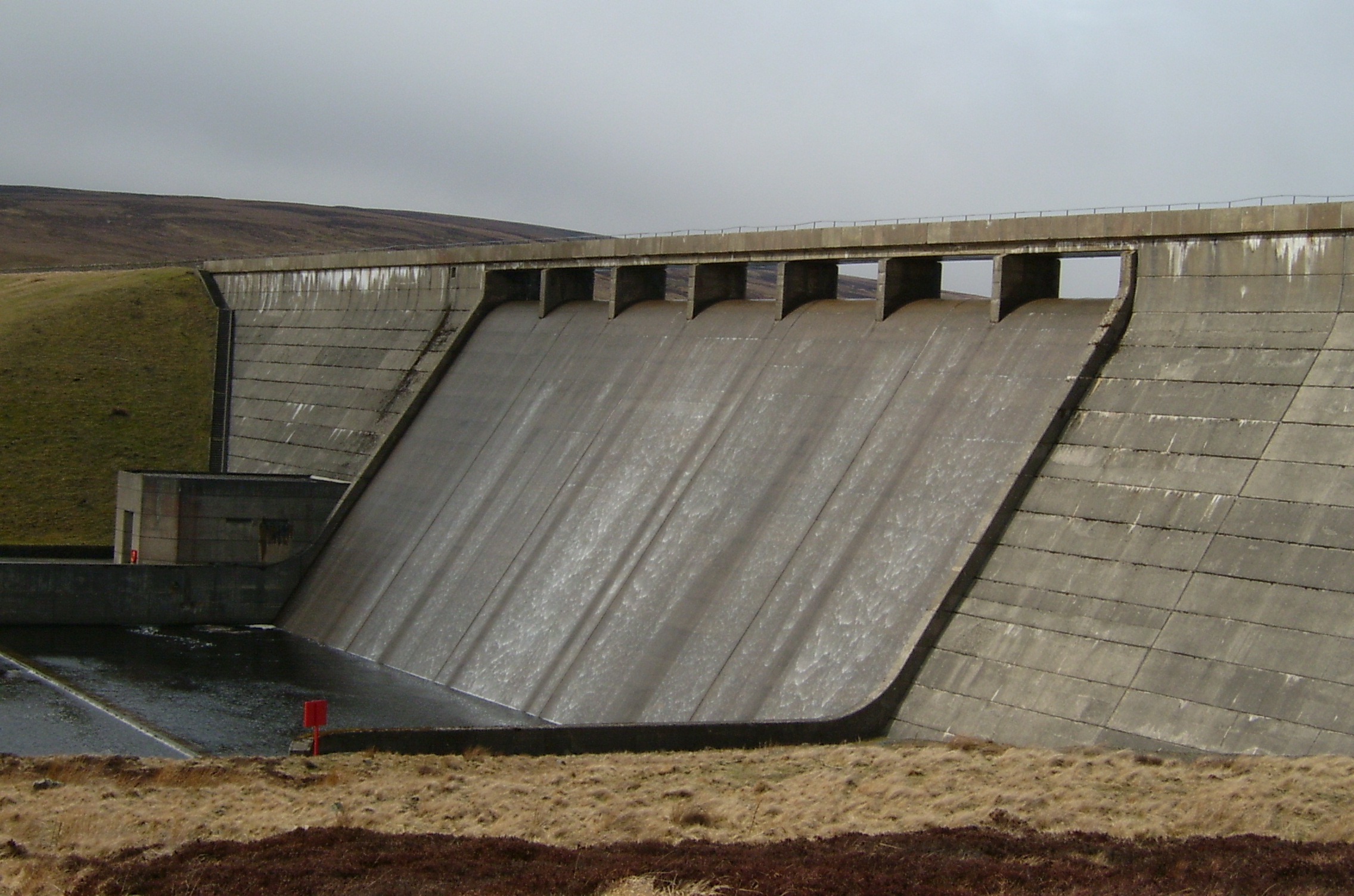
Cauldron Snout is a spectacular waterfall located in the county of Westmorland, England. It is situated in the remote and picturesque Upper Teesdale, within the North Pennines Area of Outstanding Natural Beauty. The waterfall is formed by the River Tees as it cascades down a series of rocky steps, creating a breathtaking sight for visitors.

The name "Cauldron Snout" accurately describes the appearance of the waterfall, as the rushing water resembles a cauldron boiling over. It is a popular destination for hikers and nature enthusiasts who are drawn to its raw beauty and dramatic scenery.

The waterfall measures approximately 200 meters in length, making it one of the longest continuous cascades in England. The river drops about 200 feet over a series of steps, creating a thunderous roar and a mesmerizing display of white water.

Surrounded by rugged moorland and rolling hills, Cauldron Snout offers stunning views of the surrounding landscape. The area is rich in flora and fauna, with rare alpine plants growing in the vicinity. It is also home to various bird species, including peregrine falcons and curlews.

Access to Cauldron Snout is relatively challenging, requiring a hike along the Pennine Way or a detour from the Teesdale Way. However, the effort is rewarded with the awe-inspiring sight of the waterfall and the tranquility of the remote location.

Overall, Cauldron Snout is a natural wonder that showcases the power and beauty of nature. It is a must-visit destination for those seeking an unforgettable experience in the heart of Westmorland's stunning countryside.

If you have any feedback on the listing, please let us know in the comments section below.

Cauldron Snout Images

Images are sourced within 2km of 54.652387/-2.289155 or Grid Reference NY8128. Thanks to Geograph Open Source API. All images are credited.

Road running alongside Cow Green Reservoir Looking north from a point near to the dam.
Road running alongside Cow Green Reservoir
Looking north from a point near to the dam.
Road across Cow Green Dam Capacity: 9,000 million gallons
Constructed: 1967 - 1971
Contractor: Mitchell Construction
Engineer: Rofe Kennard & Lapworth
Client: Tees Valley & Cleveland Water Board
Current Owner: Northumbrian Water
Catchment: River Tees
Road across Cow Green Dam
Capacity: 9,000 million gallons Constructed: 1967 - 1971 Contractor: Mitchell Construction Engineer: Rofe Kennard & Lapworth Client: Tees Valley & Cleveland Water Board Current Owner: Northumbrian Water Catchment: River Tees
Upper section of Cauldron Snout Cauldron Snout is a cascade on the River Tees after it exits from Cow Green Reservoir
Upper section of Cauldron Snout
Cauldron Snout is a cascade on the River Tees after it exits from Cow Green Reservoir
Cauldron Snout and Cow Green Dam The river Tees forms the Cow Green Reservoir behind the dam and then flows a short distance downstream. to the waterfall of Cauldron Snout
Cauldron Snout and Cow Green Dam
The river Tees forms the Cow Green Reservoir behind the dam and then flows a short distance downstream. to the waterfall of Cauldron Snout
On the (County Durham section of) Cow Green Dam Note the buckled safety railings!

This photograph was taken during the Coronavirus (COVID-19) pandemic of 2020/21/22.
On the (County Durham section of) Cow Green Dam
Note the buckled safety railings! This photograph was taken during the Coronavirus (COVID-19) pandemic of 2020/21/22.
The rough and tumble of the Cauldron Snout A view of the upper part of the cascade prior to prolonged rain.

This photograph was taken during the Coronavirus (COVID-19) pandemic of 2020/21/22.
The rough and tumble of the Cauldron Snout
A view of the upper part of the cascade prior to prolonged rain. This photograph was taken during the Coronavirus (COVID-19) pandemic of 2020/21/22.
River Tees flowing downstream Boulder-strewn slopes to both sides of the river, particularly the east side. There are paths on both river banks too; in places the boulders hinder progress along them.
River Tees flowing downstream
Boulder-strewn slopes to both sides of the river, particularly the east side. There are paths on both river banks too; in places the boulders hinder progress along them.
The Pennine Way near Widdy Bank
The Pennine Way near Merrygill The first of several scrambles over rocks between Merrygill and Caldron Snout.
The Pennine Way near Merrygill
The first of several scrambles over rocks between Merrygill and Caldron Snout.
The Pennine Way near Lingy Holm
The Pennine Way near Black Hill
The Pennine Way at Cauldron Snout
The Pennine Way near Cauldron Snout
The Pennine Way near Dale Byre
The Pennine Way near Birkdale
Show me another place!

Cauldron Snout is located at Grid Ref: NY8128 (Lat: 54.652387, Lng: -2.289155)

Administrative County: Cumbria

District: Eden

Police Authority: Cumbria

What 3 Words

///mandates.youths.inserting. Near Holwick, Co. Durham

Nearby Locations

Cauldron Snout

Related Wikis

Cauldron Snout

Cauldron Snout is a cascade on the upper reaches of the River Tees in Northern England, immediately below the dam of the Cow Green Reservoir. It is well...

Moor House-Upper Teesdale

Moor House-Upper Teesdale National Nature Reserve covers 7,400 ha of the Pennine moors in the north of England. It straddles Cumbria and County Durham...

Cow Green Reservoir

Cow Green Reservoir is a 2-mile (3 km) long water reservoir forming part of the border between the historic counties of Westmorland and County Durham in...

Upper Teesdale

Upper Teesdale is a Site of Special Scientific Interest (SSSI) in the west County Durham, England. It encompasses an extensive upland area that includes...

Harwood, County Durham

Harwood is a small valley and village near the head of Teesdale. Harwood Beck is a tributary of the River Tees in County Durham which forms a short valley...

Mickle Fell

Mickle Fell is a mountain in the Pennines, the range of hills and moors running down the middle of Northern England. It has a maximum elevation of 788...

Langdon Beck

Langdon Beck is a village in County Durham, England. It is situated in upper Teesdale, between Forest-in-Teesdale and Harwood, halfway between Penrith...

Forest and Frith

Forest and Frith is a civil parish in the County Durham unitary authority, in the ceremonial county of Durham, England. In the 2011 census it had a population...

Nearby Amenities

Located within 500m of 54.652387,-2.289155
Cauldron Snout (Waterfall)
Tourism: viewpoint
Wheelchair: no
Lat/Long: 54.6523897/-2.2889183
Ele: 1625 ft
Fixme: is this survey point still extant?
Man Made: survey_point
Source: NPE
Lat/Long: 54.6535388/-2.2939423
Barrier: cattle_grid
Lat/Long: 54.6533214/-2.2906714
Black Hill
Natural: peak
Source: OS_OpenData_StreetView
Lat/Long: 54.648188/-2.2891683
Passing Place
Lat/Long: 54.6545642/-2.2929911
Barrier: cattle_grid
Lat/Long: 54.6554184/-2.2905536
Cauldron Snout
Image: https://www.geograph.org.uk/photo/5565190
Waterway: waterfall
Wikidata: Q38485
Wikimedia Commons: File:Cauldron Snout - July 2006.jpg
Wikipedia: en:Cauldron Snout
Lat/Long: 54.6525698/-2.2890763
Passing Place
Lat/Long: 54.6554114/-2.2881179
The data included in this document is from www.openstreetmap.org. The data is made available under ODbL.

Have you been to Cauldron Snout?

Leave your review of Cauldron Snout below (or comments, questions and feedback).