Cowies Linn

Waterfall in Peeblesshire

Scotland

Cowies Linn

Eddleston Water Beside the trackbed of the old Peebles to Edinburgh Railway.
(Taken from a layby on the A703 polluted with much litter.)
Eddleston Water Credit: Russel Wills

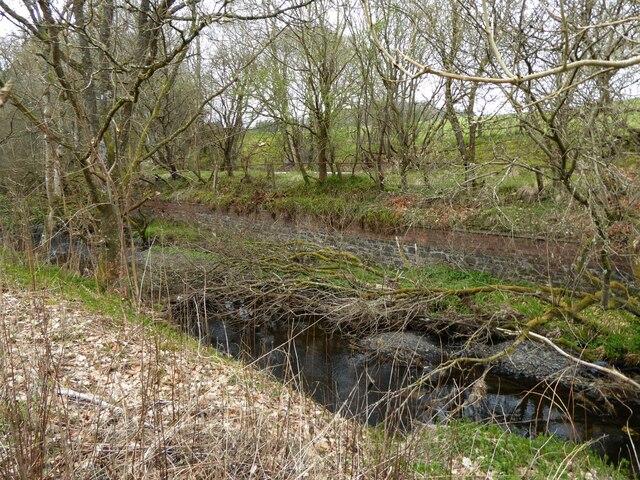
Cowies Linn is a picturesque waterfall located in Peeblesshire, Scotland. Situated near the village of Eddleston, this natural wonder is nestled within the scenic landscape of the Scottish Borders region. The name "Cowies Linn" is derived from the Scottish Gaelic word "linn," which means waterfall, and "Cowies," believed to be a corruption of the word "coo," meaning cow.

The waterfall is formed by the Cowie Burn, a small river that cascades down a series of rocky ledges, creating a stunning display of falling water. The height of the waterfall is approximately 10 meters, and its width varies depending on the water flow, which fluctuates with the seasons. The surrounding area is abundant with lush greenery, adding to the natural beauty of the site.

Access to Cowies Linn is relatively easy through a well-maintained footpath, making it a popular spot for visitors and nature enthusiasts. The path meanders through the surrounding woodland, providing glimpses of the waterfall from different angles. As one approaches the falls, the sound of rushing water becomes increasingly audible, heightening the anticipation of the breathtaking view.

Cowies Linn offers a tranquil and serene experience, with the sound of the rushing water and the scent of damp moss creating a soothing atmosphere. The surrounding area is also home to a diverse range of flora and fauna, including various species of birds and woodland plants. This makes the waterfall not only a visually appealing attraction but also an important habitat for local wildlife.

Overall, Cowies Linn is a natural gem in Peeblesshire, offering visitors a peaceful retreat and an opportunity to connect with nature amidst the stunning Scottish landscape.

If you have any feedback on the listing, please let us know in the comments section below.

Cowies Linn Images

Images are sourced within 2km of 55.750332/-3.2247907 or Grid Reference NT2351. Thanks to Geograph Open Source API. All images are credited.

Eddleston Water Beside the trackbed of the old Peebles to Edinburgh Railway.
(Taken from a layby on the A703 polluted with much litter.)
Eddleston Water
Beside the trackbed of the old Peebles to Edinburgh Railway. (Taken from a layby on the A703 polluted with much litter.)
A703 near Silverdean
The road to Lamancha Looking towards the bridge at Middle Burn between Shiplaw and Lamancha.
The road to Lamancha
Looking towards the bridge at Middle Burn between Shiplaw and Lamancha.
Sheep near Middle Burn
Triplets near Westloch The third one is hiding behind Ma. Farmland in the foothills of the Moorfoots.
Triplets near Westloch
The third one is hiding behind Ma. Farmland in the foothills of the Moorfoots.
Farmland at Westloch Not really a lone sheep - the rest were to the left.
Farmland at Westloch
Not really a lone sheep - the rest were to the left.
Cowieslin Quarry from the air Viewed from a Prague bound flight from Edinburgh
Cowieslin Quarry from the air
Viewed from a Prague bound flight from Edinburgh
Hogg Wood from the air Cowieslinn Quarry is visible to the right of centre of the photo.
Hogg Wood from the air
Cowieslinn Quarry is visible to the right of centre of the photo.
A703 at Millennium Farm entrance
A703 southbound at Silverdean
Motocross course, Shiplaw Rough moorland by the Shiplaw Burn providing a venue for motocross motorbike events. Compare the same scene in 2006: <a href="https://www.geograph.org.uk/photo/165179">NT2350 : MotoX Shiplaw</a>.
Motocross course, Shiplaw
Rough moorland by the Shiplaw Burn providing a venue for motocross motorbike events. Compare the same scene in 2006: NT2350 : MotoX Shiplaw.
Cowieslinn Burn bridge On the minor road between Shiplaw and the A701 at Whim Farm.
Cowieslinn Burn bridge
On the minor road between Shiplaw and the A701 at Whim Farm.
Forest road and Dundreich The forest road from Shiplaw over to Noblehouse on the A701. The wind damaged area (<a href="https://www.geograph.org.uk/photo/3850091">NT2150 : Wind damage in Cloich Forest</a>) is to the right. Bowbeat wind farm is on the skyline by Dundreich.
Forest road and Dundreich
The forest road from Shiplaw over to Noblehouse on the A701. The wind damaged area (NT2150 : Wind damage in Cloich Forest) is to the right. Bowbeat wind farm is on the skyline by Dundreich.
Cottage and driveway to Earlypier Of the A703 Peebles to Penicuik road.
Cottage and driveway to Earlypier
Of the A703 Peebles to Penicuik road.
Bridge over the Eddleston Water An access to Earlyvale off the A703, which appears to be disused.
Bridge over the Eddleston Water
An access to Earlyvale off the A703, which appears to be disused.
Waterheads Farm Tuley tubes in the foreground for protecting saplings.
Waterheads Farm
Tuley tubes in the foreground for protecting saplings.
Silverdean The road from Temple drops down to join the A703 just beyond the house.
Silverdean
The road from Temple drops down to join the A703 just beyond the house.
Bend in the road The road from Temple bends sharply to drop down to the A703. Sheep on the hillside opposite.
Bend in the road
The road from Temple bends sharply to drop down to the A703. Sheep on the hillside opposite.
Show me another place!

Cowies Linn is located at Grid Ref: NT2351 (Lat: 55.750332, Lng: -3.2247907)

Unitary Authority: The Scottish Borders

Police Authority: The Lothians and Scottish Borders

What 3 Words

///revolting.humans.barman. Near West Linton, Scottish Borders

Related Wikis

Earlyvale Gate railway station

Earlyvale Gate railway station served the Dundas family residence in Earlyvale, Scottish Borders, Scotland for 8 months (June 1856 - February 1857) on...

Tweeddale

Tweeddale (Scottish Gaelic: Srath Thuaidh/Tuaidhdail) is a committee area and lieutenancy area in the Scottish Borders council area in south-eastern Scotland...

Lamancha railway station

Lamancha railway station served the hamlet of Lamancha, Peeblesshire, Scotland, from 1864 to 1933 on the Leadburn, Linton and Dolphinton Railway. ��2...

Northshield Rings

Northshield Rings is a prehistoric site, a hillfort near the village of Eddleston and about 6 miles (10 km) north of Peebles, in the Scottish Borders,...

Nearby Amenities

Located within 500m of 55.750332,-3.2247907
Power: pole
Lat/Long: 55.7542477/-3.2234472
Power: pole
Lat/Long: 55.7535537/-3.2228233
Power: pole
Lat/Long: 55.7528322/-3.2228608
Power: pole
Lat/Long: 55.7517243/-3.2229198
Power: pole
Lat/Long: 55.750879/-3.2229359
Power: pole
Lat/Long: 55.7501332/-3.222952
Power: pole
Lat/Long: 55.7497564/-3.2229636
Power: pole
Lat/Long: 55.7485029/-3.2230379
Power: pole
Lat/Long: 55.747933/-3.2230603
Power: pole
Lat/Long: 55.7472907/-3.2231012
Power: pole
Lat/Long: 55.7468243/-3.2239055
Power: pole
Lat/Long: 55.7464075/-3.2246257
Power: pole
Lat/Long: 55.7459878/-3.2253714
Power: pole
Lat/Long: 55.7458943/-3.2251985
Power: pole
Lat/Long: 55.7463048/-3.2244773
Power: pole
Lat/Long: 55.7467449/-3.2236772
Power: pole
Lat/Long: 55.747228/-3.2228618
Power: pole
Lat/Long: 55.7478544/-3.2228044
Power: pole
Lat/Long: 55.7484831/-3.2227831
Power: pole
Lat/Long: 55.7500167/-3.2227429
Power: pole
Lat/Long: 55.7505771/-3.2227081
Power: pole
Lat/Long: 55.7513396/-3.2226693
Power: pole
Lat/Long: 55.7521432/-3.2226257
Power: pole
Lat/Long: 55.7528647/-3.2225989
Power: pole
Lat/Long: 55.7536043/-3.2225614
Power: pole
Lat/Long: 55.7542194/-3.2231613
Power: pole
Lat/Long: 55.7503445/-3.2232874
Power: pole
Lat/Long: 55.7521903/-3.222895
The data included in this document is from www.openstreetmap.org. The data is made available under ODbL.

Have you been to Cowies Linn?

Leave your review of Cowies Linn below (or comments, questions and feedback).