Dearsley Island

Island in Buckinghamshire

England

Dearsley Island

Egham station This shows the up-side frontage as rebuilt in 1985.
Egham station Credit: David Kemp

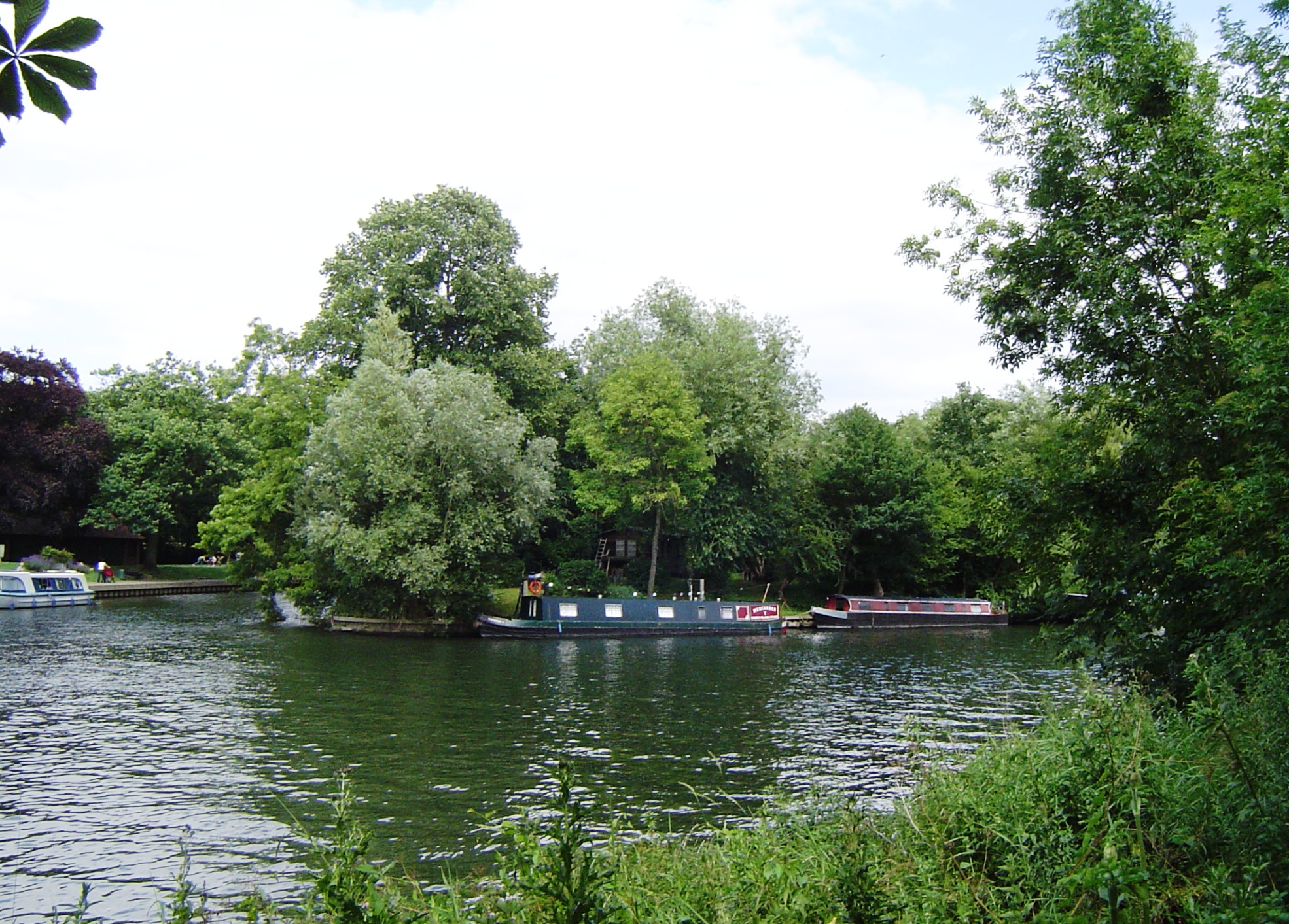
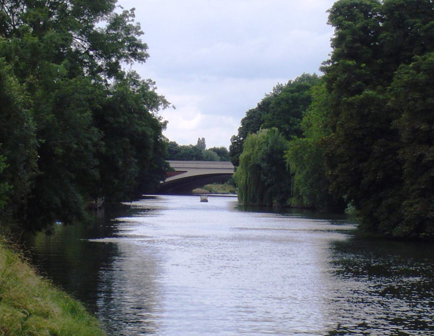
Dearsley Island is a small, picturesque island located in Buckinghamshire, England. Situated within the River Thames, the island boasts a tranquil and idyllic setting that attracts visitors from far and wide.

Covering an area of approximately 2.5 acres, Dearsley Island is accessible only by boat, which adds to its charm and exclusivity. The island is surrounded by lush greenery and offers stunning panoramic views of the river and the surrounding countryside. Its remote location makes it a perfect retreat for those seeking peace and solitude.

The island is home to a single, beautifully designed house, which serves as a private residence. The house is a testament to architectural excellence, with its elegant design and modern amenities. It is surrounded by well-maintained gardens and a small orchard which adds to the island's natural beauty.

Dearsley Island is also known for its diverse wildlife. The island provides a habitat for a variety of birds, including herons and swans, which can often be spotted gracefully gliding over the river. The surrounding waters are also abundant in fish, making it a popular spot for fishing enthusiasts.

While the island is primarily a private residence, occasional events and gatherings are held on its grounds. These events offer a unique opportunity for visitors to experience the island's charm and beauty.

In conclusion, Dearsley Island is a hidden gem in Buckinghamshire, offering a peaceful and picturesque retreat for those seeking an escape from the hustle and bustle of everyday life. With its stunning natural surroundings and exclusive location, it is truly a haven of tranquility.

If you have any feedback on the listing, please let us know in the comments section below.

Dearsley Island Images

Images are sourced within 2km of 51.4427/-0.53622688 or Grid Reference TQ0172. Thanks to Geograph Open Source API. All images are credited.

Egham station This shows the up-side frontage as rebuilt in 1985.
Egham station
This shows the up-side frontage as rebuilt in 1985.
St John the Baptist, Egham - south elevation
St John the Baptist, Egham - north elevation
High Street, Egham This is the north side looking east.
High Street, Egham
This is the north side looking east.
Ongoing construction work, Egham This was taken where Church Road (running left-right) is met by Station Road (foreground).
Ongoing construction work, Egham
This was taken where Church Road (running left-right) is met by Station Road (foreground).
Approaching the A30/M25 junction
Motorway gantry - M25 northbound
House on Staines Road, Wraysbury
Bus stop on Staines Road (B376), Wraysbury
Staines Road (B376)
Staines Road (B376)
Road to sailing club Off Staines Road (B376).
Road to sailing club
Off Staines Road (B376).
Houses on Staines Road (B376)
B376 towards Staines
Spice Village Indian Restaurant & Bar, Hythe End
Sign for the Spice Village Indian Restaurant & Bar, Hythe End
Houses on Wraysbury Road
A30 / M25 Motorway bridge over Wraysbury Road (B376)
Show me another place!

Dearsley Island is located at Grid Ref: TQ0172 (Lat: 51.4427, Lng: -0.53622688)

Unitary Authority: Windsor and Maidenhead

Police Authority: Thames Valley

What 3 Words

///bags.swaps.follow. Near Egham, Surrey

Related Wikis

Colne Brook

The Colne Brook is a river in England that is a distributary of the River Colne which runs from Uxbridge Moor, there forming the western border of Greater...

Bell Weir Lock

Bell Weir Lock is a lock on the River Thames in England by the right bank, Runnymede which is a water meadow associated with Egham of importance for the...

Runnymede Bridge

Runnymede Bridge is a motorway, A-road, pedestrian, and cycle bridge, built in the 1960s and 1980s and expanded in the 2000s, carrying the M25 and A30...

The Island, Hythe End

The Island is an inhabited island in the River Thames in England on the reach above Bell Weir Lock, a part of the Hythe End part of Wraysbury village...

Wraysbury Skiff and Punting Club

Wraysbury Skiff and Punting Club (WSPC) is an English skiff and punting club founded in 1931 based on the River Thames at the start of the Surrey section...

Hollyhock Island

Hollyhock Island is an inhabited island in the River Thames in England on the reach between Bell Weir Lock and Penton Hook Lock. == Location == The island...

Holm Island

Holm Island is an island in the River Thames in England on the reach above Penton Hook Lock, near Staines. It is on the Buckinghamshire bank, just upstream...

Wraysbury and Hythe End Gravel Pits

Wraysbury and Hythe End Gravel Pits is a 117.2-hectare (290-acre) biological Site of Special Scientific Interest in Wraysbury in Berkshire. It is part...

Nearby Amenities

Located within 500m of 51.4427,-0.53622688
Bus Stop
Feathers PH
Alt Name: Hythe End Bridge
Bus: yes
Naptan AltCommonName: Hythe End Bridge
Naptan AltStreet: Not Specified
Naptan AtcoCode: 036006470471
Naptan Bearing: W
Naptan CommonName: Feathers PH
Naptan Indicator: W-bound
Naptan Landmark: Feathers Lane
Naptan NaptanCode: windpmp
Naptan Street: Wraysbury Road
Naptan Verified: no
Public Transport: platform
Source: naptan_import
Lat/Long: 51.4439643/-0.53867
Bus Stop
Garden Centre
Bus: yes
Naptan AtcoCode: 036006774774
Naptan Bearing: NW
Naptan CommonName: Garden Centre
Naptan Indicator: adj
Naptan Landmark: Colne Way
Naptan NaptanCode: windwtd
Naptan Street: Wraysbury Road
Naptan Verified: no
Public Transport: platform
Source: naptan_import
Lat/Long: 51.442514/-0.5331899
Bus Stop
Garden Centre
Bus: yes
Naptan AtcoCode: 036006774775
Naptan Bearing: SE
Naptan CommonName: Garden Centre
Naptan Indicator: opp
Naptan Landmark: Colne Way
Naptan NaptanCode: windwtg
Naptan Street: Wraysbury Road
Naptan Verified: no
Public Transport: platform
Source: naptan_import
Lat/Long: 51.4423654/-0.532647
Traffic Signals
Source: Bing
Traffic Signals: signal
Traffic Signals Direction: forward
Lat/Long: 51.4447779/-0.5305754
Motorway Junction
Runnymede
Ref: 13
Lat/Long: 51.4390136/-0.532826
Barrier: cycle_barrier
Cycle Barrier: double
Source: GPS survey
Lat/Long: 51.4385993/-0.5387785
Restaurant
Spice Lounge
Cuisine: indian
Lat/Long: 51.4441064/-0.5389621
Traffic Signals
Traffic Signals: signal
Traffic Signals Direction: forward
Lat/Long: 51.4448839/-0.5307914
Traffic Signals
Source: Bing
Traffic Signals: signal
Traffic Signals Direction: forward
Lat/Long: 51.4438209/-0.5305438
Traffic Signals
Source: Bing
Traffic Signals: signal
Traffic Signals Direction: forward
Lat/Long: 51.4438553/-0.5303469
Hythe End
Place: village
Wikidata: Q13129212
Lat/Long: 51.4432437/-0.5378477
Dearsley Island
Place: locality
Lat/Long: 51.4429283/-0.5363719
Street Lamp
Lamp Model: Philips SGS306
Lamp Type: SON
Source: Mapillary (2019-02-15)
Lat/Long: 51.4405988/-0.531396
Street Lamp
Lamp Model: Philips SGS306
Lamp Type: SON
Source: Mapillary (2019-02-15)
Lat/Long: 51.4391977/-0.5324635
Street Lamp
Lamp Model: Philips SGS306
Lamp Type: SON
Source: Mapillary (2019-02-15)
Lat/Long: 51.4401039/-0.5316991
Street Lamp
Lamp Model: Philips SGS306
Lamp Type: SON
Source: Mapillary (2019-02-15)
Lat/Long: 51.4396542/-0.5320585
Street Lamp
Lamp Model: Philips SGS306
Lamp Type: SON
Source: Mapillary (2019-02-15)
Lat/Long: 51.4430932/-0.5302158
Street Lamp
Lamp Model: Philips SGS306
Lamp Type: SON
Source: Mapillary (2019-02-15)
Lat/Long: 51.4435513/-0.5299718
Street Lamp
Lamp Model: Philips SGS306
Lamp Type: SON
Source: Mapillary (2019-02-15)
Lat/Long: 51.4387664/-0.5328954
Street Lamp
Lamp Model: Philips SGS306
Lamp Type: SON
Source: Mapillary (2019-02-15)
Lat/Long: 51.4410937/-0.5311224
Street Lamp
Lamp Model: Philips SGS306
Lamp Type: SON
Source: Mapillary (2019-02-15)
Lat/Long: 51.442605/-0.5304411
Street Lamp
Lamp Model: Philips SGS306
Lamp Type: SON
Source: Mapillary (2019-02-15)
Lat/Long: 51.4421135/-0.5306584
Street Lamp
Lamp Model: Philips SGS306
Lamp Type: SON
Source: Mapillary (2019-02-15)
Lat/Long: 51.4416187/-0.5308757
Street Lamp
Lamp Model: Philips SGS306
Lamp Type: SON
Source: Mapillary (2019-02-15)
Lat/Long: 51.4440327/-0.5296794
Shop: car_repair
Lat/Long: 51.4441064/-0.5367648
Surrey Lodge Motor Co
Addr Housename: Bellweir Garage
Addr Street: Wraysbury Road
Service Vehicle Air Conditioning: yes
Service Vehicle Mot: yes
Service Vehicle Tyres: yes
Shop: car_repair
Lat/Long: 51.4441231/-0.5369901
Direction: 200
Generator Method: photovoltaic
Generator Output Electricity: yes
Generator Solar Modules: 16
Generator Source: solar
Generator Type: solar_photovoltaic_panel
Location: roof
Power: generator
Lat/Long: 51.4433363/-0.5372471
Barrier: stile
Material: wood
Note: Just a simple pallet in a barbed wire fence
Stile: stepover
Lat/Long: 51.4450549/-0.5410391
Traffic Sign: variable_message
Variable Message Model: MS2
Lat/Long: 51.4399232/-0.5315379
Traffic Sign: variable_message
Variable Message Model: AMI
Lat/Long: 51.4398985/-0.5314506
Traffic Sign: variable_message
Variable Message Model: AMI
Lat/Long: 51.4399426/-0.5316062
Traffic Sign: variable_message
Variable Message Model: AMI
Lat/Long: 51.4399569/-0.5316566
Traffic Sign: variable_message
Variable Message Model: AMI
Lat/Long: 51.4399713/-0.5317075
Traffic Sign: variable_message
Variable Message Model: AMI
Lat/Long: 51.4399855/-0.5317574
Phone
Emergency: phone
Operator: National Highways
Operator Type: government
Operator Wikidata: Q5760006
Lat/Long: 51.4416699/-0.5305463
Phone
Emergency: phone
Operator: National Highways
Operator Type: government
Operator Wikidata: Q5760006
Lat/Long: 51.4444179/-0.5297604
Phone
Emergency: phone
Operator: National Highways
Operator Type: government
Operator Wikidata: Q5760006
Lat/Long: 51.4418007/-0.5311324
Traffic Sign: variable_message
Variable Message Model: MS2
Lat/Long: 51.4397846/-0.532254
Traffic Sign: variable_message
Variable Message Model: AMI
Lat/Long: 51.4397266/-0.5320625
Traffic Sign: variable_message
Variable Message Model: AMI
Lat/Long: 51.4397408/-0.5321095
Traffic Sign: variable_message
Variable Message Model: AMI
Lat/Long: 51.4397555/-0.532158
Traffic Sign: variable_message
Variable Message Model: AMI
Lat/Long: 51.4397696/-0.5322044
Traffic Sign: variable_message
Variable Message Model: AMI
Lat/Long: 51.4398044/-0.5323193
Traffic Sign: variable_message
Variable Message Model: AMI
Lat/Long: 51.4398174/-0.5323619
Waterway: weir
Lat/Long: 51.4418762/-0.5355647
Colour: yellow
Marker: post
Material: plastic
Utility: gas
Lat/Long: 51.4409784/-0.530436
The data included in this document is from www.openstreetmap.org. The data is made available under ODbL.

Have you been to Dearsley Island?

Leave your review of Dearsley Island below (or comments, questions and feedback).