Isle of Noss

Island in Shetland

Scotland

Isle of Noss

Noss ferry approaching the Bressay shore
Noss ferry approaching the Bressay shore Credit: Mike Pennington

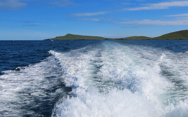
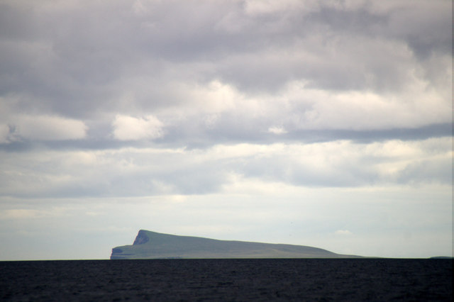
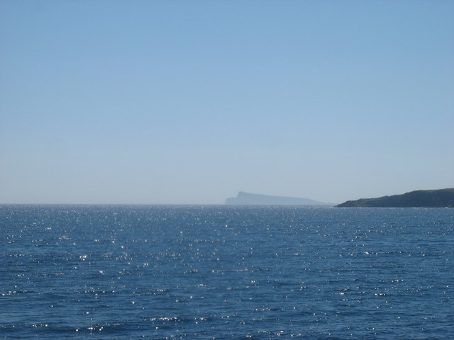
The Isle of Noss, located in the Shetland Islands of Scotland, is a small island known for its stunning natural beauty and diverse wildlife. Covering an area of approximately 313 hectares, it lies off the east coast of the larger island of Bressay, and is separated from it by the narrow Noss Sound.

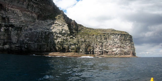
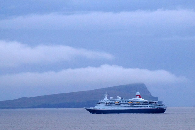
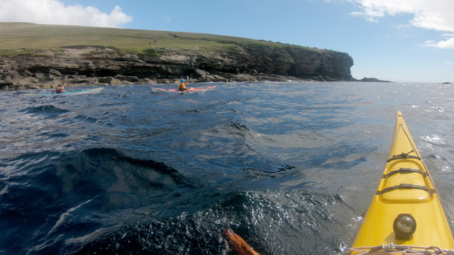
The island is characterized by its dramatic cliffs, which reach heights of up to 180 meters, and its rugged terrain. These cliffs provide nesting sites for an array of seabirds, including over 150,000 pairs of gannets, making it one of the largest gannetries in the country. Visitors to the island can witness the mesmerizing sight of gannets diving into the sea in search of fish.

Apart from gannets, the Isle of Noss is also home to numerous other bird species, such as puffins, guillemots, razorbills, and fulmars. The island boasts a rich biodiversity, with its grassy slopes and heathland supporting a variety of plant species, including orchids and primroses.

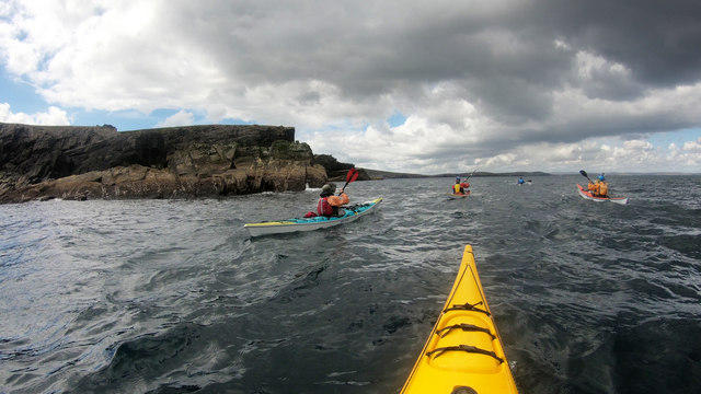
Access to the Isle of Noss is restricted during the breeding season, which typically runs from April to August, to protect the fragile ecosystem and ensure the undisturbed breeding of its feathered inhabitants. However, guided boat tours are available during this time, allowing visitors to experience the island's natural wonders from a safe distance.

In addition to its ecological importance, the Isle of Noss offers breathtaking views of the surrounding coastline and is a popular destination for hikers and nature enthusiasts. Its rugged landscapes and abundant wildlife make it a must-visit location for anyone seeking an authentic and awe-inspiring Scottish island experience.

If you have any feedback on the listing, please let us know in the comments section below.

Isle of Noss Images

Images are sourced within 2km of 60.143887/-1.025296 or Grid Reference HU5440. Thanks to Geograph Open Source API. All images are credited.

Noss ferry approaching the Bressay shore
Gungstie, Noss, from Noss Sound
Noss-sound, Bressay, from Noss Sound
Noss National Nature Reserve Taken from a tour boat moored in Nesti Voe, Noss, Shetland, I am looking west to Big Ness where the wardens of Noss National Nature Reserve are located. NatureScot operates an inflatable ferry boat across Noss Sound (beyond the buildings pictured) during the summer months to allow walkers to get from Bressay to Noss.
Noss National Nature Reserve
Taken from a tour boat moored in Nesti Voe, Noss, Shetland, I am looking west to Big Ness where the wardens of Noss National Nature Reserve are located. NatureScot operates an inflatable ferry boat across Noss Sound (beyond the buildings pictured) during the summer months to allow walkers to get from Bressay to Noss.
Gungstie, Noss I am looking back as we leave Noss Sound, Shetland, on our way back to Lerwick.  The rocky outcrop of Gungstie is to the right of shot and the distinctive Hill of Setter (to the south of Noss) can be seen in the distance.
Gungstie, Noss
I am looking back as we leave Noss Sound, Shetland, on our way back to Lerwick. The rocky outcrop of Gungstie is to the right of shot and the distinctive Hill of Setter (to the south of Noss) can be seen in the distance.
Hill of Setter, Noss Taken as we pass north east along the coast of Bressay, en route back to Lerwick, Shetland, I am looking back towards the distinctive Hill of Setter on Noss.
Hill of Setter, Noss
Taken as we pass north east along the coast of Bressay, en route back to Lerwick, Shetland, I am looking back towards the distinctive Hill of Setter on Noss.
Noss from Lunning Sound
Getting onto the Noss ferry Whilst the Bressay ferry used to get here takes vehicles and has a "proper" dock, the Noss ferry is only for very small numbers of pedestrians, so needs no more than a set of steps down to sea level. There's no timetable - when the ferryman notices that there are people waiting, he will come across to get them. Whether this works on foggy days is another question entirely, and not one we needed answered, as we were visiting in our own boats, just popping over to look at the ferry terminal out of curiosity.
Getting onto the Noss ferry
Whilst the Bressay ferry used to get here takes vehicles and has a "proper" dock, the Noss ferry is only for very small numbers of pedestrians, so needs no more than a set of steps down to sea level. There's no timetable - when the ferryman notices that there are people waiting, he will come across to get them. Whether this works on foggy days is another question entirely, and not one we needed answered, as we were visiting in our own boats, just popping over to look at the ferry terminal out of curiosity.
Paddling down Noss Sound Somehow, using a map, one always thinks of heading south as "down" though, of course, on average, the sea is level, and as we were going against the very start of the flood tide we might actually be going a tiny bit uphill ! Tidal flows at Noss are generally insignificant except in this shallow channel, and we were going anticlockwise round the island more to have the sun behind us on the scenic side than to take any advantage of the flow. The boat powering away from us had been stationary as we arrived, but seemed to form a sudden desire to leave as (or perhaps before) their clients realised just how much closer to the wildlife sea kayakers can get than anyone in a big boat. The Sound had already given us close encounters with Seals, Eider, Cormorants and Terns diving in just metres away. The outer side promised huge numbers of Gannets and Razorbills...
Paddling down Noss Sound
Somehow, using a map, one always thinks of heading south as "down" though, of course, on average, the sea is level, and as we were going against the very start of the flood tide we might actually be going a tiny bit uphill ! Tidal flows at Noss are generally insignificant except in this shallow channel, and we were going anticlockwise round the island more to have the sun behind us on the scenic side than to take any advantage of the flow. The boat powering away from us had been stationary as we arrived, but seemed to form a sudden desire to leave as (or perhaps before) their clients realised just how much closer to the wildlife sea kayakers can get than anyone in a big boat. The Sound had already given us close encounters with Seals, Eider, Cormorants and Terns diving in just metres away. The outer side promised huge numbers of Gannets and Razorbills...
Gannets on The Rump, Noss The prime nesting sites in any gannetry are the flatter ones in positions still inaccessible to land predators from above. Easier, safer landings are one obvious benefit (a couple of days after this photo was taken, we came across a Gannet which had got its approach wrong and was hanging, dead, by one wing from a crack in the cliff - gusty downdraughts can hit at any time so misjudgements aren't the only cause of accidents).

Beyond The Rump, the cliffs return to the vertical once more at Point of Heogatoug, beyond which the coast gets lower, and the bird nesting paradise soon comes to an end. It's an exciting couple of kilometres of paddling up to this point.
Gannets on The Rump, Noss
The prime nesting sites in any gannetry are the flatter ones in positions still inaccessible to land predators from above. Easier, safer landings are one obvious benefit (a couple of days after this photo was taken, we came across a Gannet which had got its approach wrong and was hanging, dead, by one wing from a crack in the cliff - gusty downdraughts can hit at any time so misjudgements aren't the only cause of accidents). Beyond The Rump, the cliffs return to the vertical once more at Point of Heogatoug, beyond which the coast gets lower, and the bird nesting paradise soon comes to an end. It's an exciting couple of kilometres of paddling up to this point.
Paddling past Scarfi Skerries Paddling anticlockwise round the island of Noss, Scarfi Skerries and East Punds Geo, just beyond, are almost the last rock-hopping opportunities. After Point of Pundsgeo, the coast is a little more subdued, and our route would take us further out on our way back towards Bressay, whose easternmost point lies on the Loder Head peninsula at Rules Ness, pretty much directly in front of the most distant paddler in the photo. There are far fewer birds here than on the east coast, but inland, the island is still inhabited by heavy tripod-toting chaps in camouflage jackets. They seem to move more slowly than sea kayakers, though that might simply mean that they stop more often to take photos.
Paddling past Scarfi Skerries
Paddling anticlockwise round the island of Noss, Scarfi Skerries and East Punds Geo, just beyond, are almost the last rock-hopping opportunities. After Point of Pundsgeo, the coast is a little more subdued, and our route would take us further out on our way back towards Bressay, whose easternmost point lies on the Loder Head peninsula at Rules Ness, pretty much directly in front of the most distant paddler in the photo. There are far fewer birds here than on the east coast, but inland, the island is still inhabited by heavy tripod-toting chaps in camouflage jackets. They seem to move more slowly than sea kayakers, though that might simply mean that they stop more often to take photos.
Landing on Noss Although, coming from Voe of Cullingsborough round Loder Head, we hadn't paddled very far to reach Noss, the island offers few other landing places apart from the west side, facing Bressay across Noss Sound. Thus our group stopped for an early lunch in anticipation that we would be on the water for rather longer to complete our trip all the way round. This beach is just north of the tourist ferry landing, out of their way, and even seemed quite sheltered (we'd had a very windy 24 hours the previous day and the open sea was still quite lumpy, whilst here in the Sound it was essentially flat).
Landing on Noss
Although, coming from Voe of Cullingsborough round Loder Head, we hadn't paddled very far to reach Noss, the island offers few other landing places apart from the west side, facing Bressay across Noss Sound. Thus our group stopped for an early lunch in anticipation that we would be on the water for rather longer to complete our trip all the way round. This beach is just north of the tourist ferry landing, out of their way, and even seemed quite sheltered (we'd had a very windy 24 hours the previous day and the open sea was still quite lumpy, whilst here in the Sound it was essentially flat).
Rounding Big Ness into Nesti Voe Big Ness is really quite a small peninsula, ending in these low shoreline rocks. Beyond to the left is Nesti Voe, with a big beach, but an onshore wind, so not what we wanted for a lunch stop. Across the Voe is Turr Ness, a somewhat rockier and longer peninsula with enough height to conceal our onward route to reach the east coast of Noss. The hill in partial shadow is Hill of Setter, rising to 181m directly above the cliffs and gannetry of Noss Head, though you'd scarcely guess that seeing it from the west. The whole island is a nature reserve, gentle slopes being mainly inhabited by chaps in camouflage jackets carrying large cameras and even bigger tripods. Must be something worthwhile to see then, so let's keep paddling !
Rounding Big Ness into Nesti Voe
Big Ness is really quite a small peninsula, ending in these low shoreline rocks. Beyond to the left is Nesti Voe, with a big beach, but an onshore wind, so not what we wanted for a lunch stop. Across the Voe is Turr Ness, a somewhat rockier and longer peninsula with enough height to conceal our onward route to reach the east coast of Noss. The hill in partial shadow is Hill of Setter, rising to 181m directly above the cliffs and gannetry of Noss Head, though you'd scarcely guess that seeing it from the west. The whole island is a nature reserve, gentle slopes being mainly inhabited by chaps in camouflage jackets carrying large cameras and even bigger tripods. Must be something worthwhile to see then, so let's keep paddling !
Mansie's Berg, Noss, from the sea
The Noss ferry on the Bressay side of Noss Sound
Noss Head Seen from the Whalsay ferry en route between Symbister and Laxo.

I do not normally submit this type of 'long distance view' with no foreground, but this one seemed interesting enough to add to the site.
Noss Head
Seen from the Whalsay ferry en route between Symbister and Laxo. I do not normally submit this type of 'long distance view' with no foreground, but this one seemed interesting enough to add to the site.
Noss from the SW, with a cruise ship on its way to Lerwick The ship is the MV Boudicca, a cruise ship owned and operated by Fred Olsen Cruise Lines, which was built in 1973 by Wärtsilä Helsinki Shipyard in Finland as Royal Viking Sky.
Noss from the SW, with a cruise ship on its way to Lerwick
The ship is the MV Boudicca, a cruise ship owned and operated by Fred Olsen Cruise Lines, which was built in 1973 by Wärtsilä Helsinki Shipyard in Finland as Royal Viking Sky.
Paddling past the Point and Geos of Hovie Although we'd picked the sheltered side of Shetland after a day of high wind on our crossing from mainland Scotland, there was still some swell setting in from the east. Across that, wind waves from the southwest made for interesting conditions round the south side of Noss, with confused water particularly around the headland ahead of us. It still seemed less work than the people on the slopes of Hill of Setter who were trekking across above us with a big camera and heavy-looking tripod. It's a bit of a toss-up as to who would get the closer views of the Gannets and Razorbills - we would certainly feel safer down here than teetering on the cliff edge in the gusty wind, and find Razorbills rafting on the surface, but then they'd probably get better photos than those below in the waves !
Paddling past the Point and Geos of Hovie
Although we'd picked the sheltered side of Shetland after a day of high wind on our crossing from mainland Scotland, there was still some swell setting in from the east. Across that, wind waves from the southwest made for interesting conditions round the south side of Noss, with confused water particularly around the headland ahead of us. It still seemed less work than the people on the slopes of Hill of Setter who were trekking across above us with a big camera and heavy-looking tripod. It's a bit of a toss-up as to who would get the closer views of the Gannets and Razorbills - we would certainly feel safer down here than teetering on the cliff edge in the gusty wind, and find Razorbills rafting on the surface, but then they'd probably get better photos than those below in the waves !
Show me another place!

Isle of Noss is located at Grid Ref: HU5440 (Lat: 60.143887, Lng: -1.025296)

Unitary Authority: Shetland Islands

Police Authority: Highlands and Islands

What 3 Words

///land.screeches.furnish. Near Lerwick, Shetland Islands

Related Wikis

Isle of Noss

The Isle of Noss or Noss (Scots: Noss) is a small, previously inhabited island in Shetland, Scotland. Noss is separated from the island of Bressay by the...

Holm of Noss

The Holm of Noss or Cradle Holm is an uninhabited islet of the Shetland Islands. It is about 48m at its highest point. == Geography and geology == It is...

Broch of Cullingsburgh

The Broch of Cullingsburgh is an Iron Age broch located in the Shetland islands. == Location == Located on Bressay, off the east coast of mainland Shetland...

Voe of Cullingsburgh

Voe of Cullingsburgh is a large sea loch off the Shetland island of Bressay, voe meaning "sea inlet" in Shetland dialect. The local spelling of the name...

Bressay

Bressay (Scots: Bressa) is a populated island in the Shetland archipelago of Scotland. == Geography and geology == Bressay lies due south of Whalsay, west...

Bressay transmitting station

Bressay transmitting station is a broadcasting transmission facility for the Shetland Islands, located on the isle of Bressay, owned and operated by Arqiva...

Gardie House

Gardie House is an 18th-century estate house on Bressay in Shetland, Scotland. Located opposite Lerwick, across the Bressay Sound, Gardie is described...

Lerwick and Bressay Parish Church

Lerwick and Bressay Parish Church is the largest Church of Scotland congregation in Shetland, serving the islands' capital Lerwick and the surrounding...

Have you been to Isle of Noss?

Leave your review of Isle of Noss below (or comments, questions and feedback).