Fugla Skerry

Island in Shetland

Scotland

Fugla Skerry

The Orkneyman's Cave, Bressay Known locally as the Orkneyman's Cave*, this is the Cave of the Bard on the headland of the same name, Bressay, Shetland.

*A popular myth is that this cave was used as a hiding place for a man from Orkney evading a press-gang; although his boat is said to have washed away in a storm, he managed to climb the cliffs onto Bressay and make his escape.
The Orkneyman's Cave, Bressay Credit: Carroll Pierce

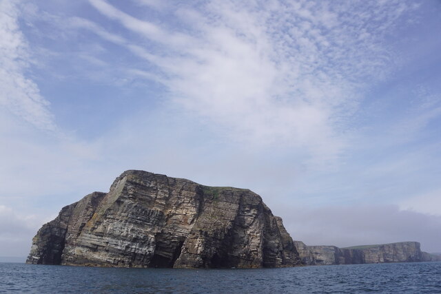
Fugla Skerry is a small uninhabited island located off the coast of Shetland, Scotland. It is situated in the North Atlantic Ocean, approximately 3.5 miles northeast of the main island of Shetland. The island is part of the Shetland Islands archipelago, which comprises more than 100 islands.

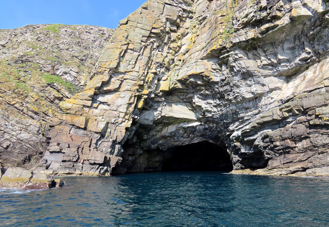
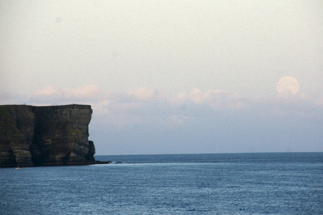
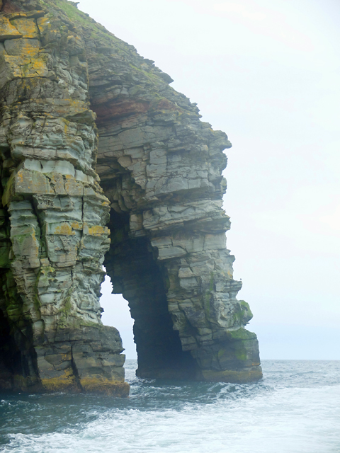
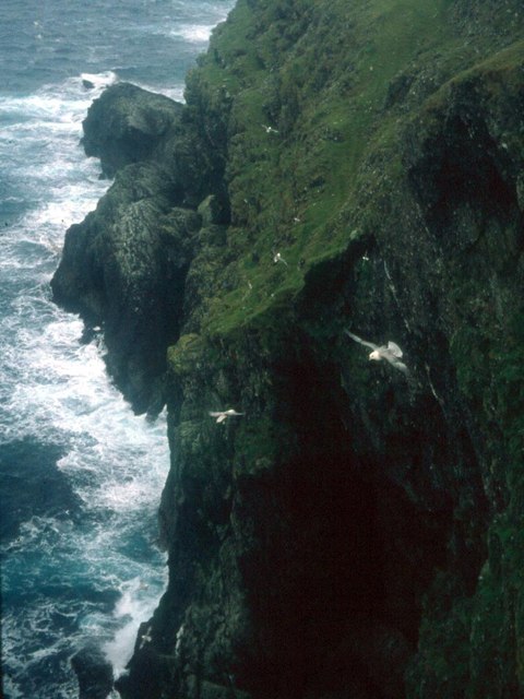
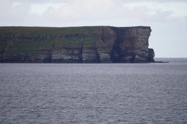
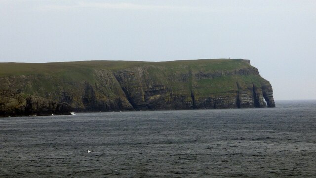
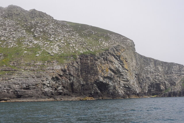
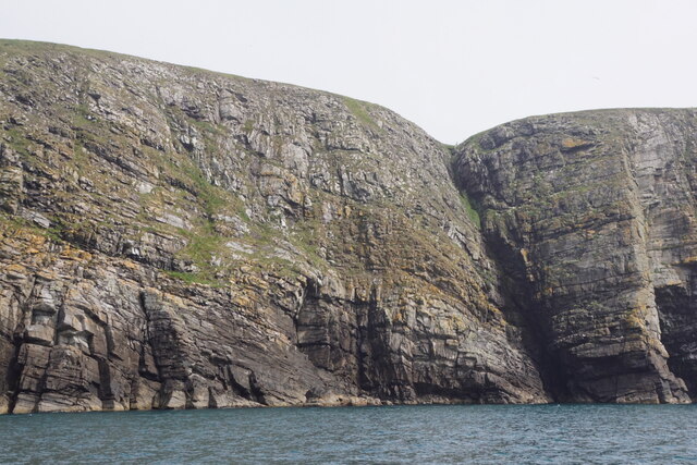
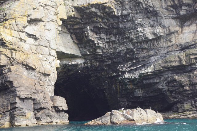
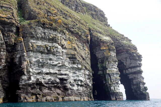
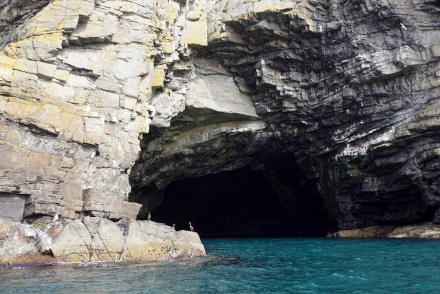
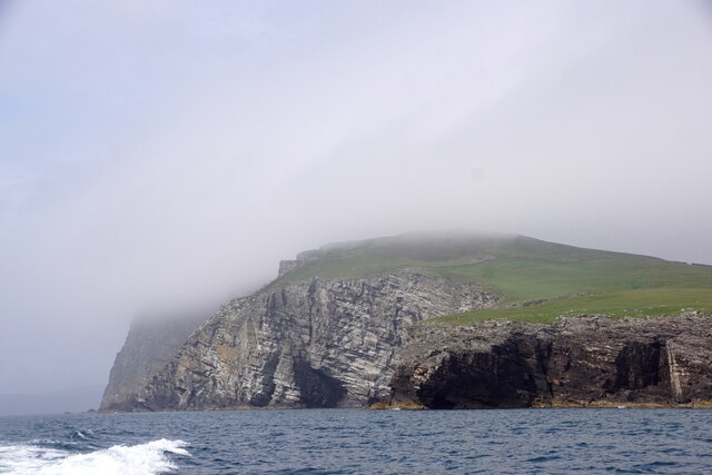
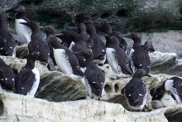
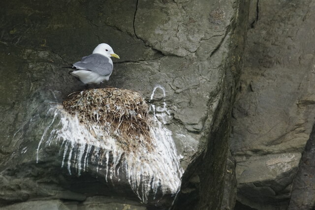
Fugla Skerry is a rocky island with an area of about 5 hectares (12 acres). Its terrain is rugged and dominated by steep cliffs that are up to 100 feet in height. The island gets its name from the abundance of birdlife that inhabits the area. "Fugla" is the Shetlandic word for "bird," reflecting the importance of the island as a breeding ground for various avian species.

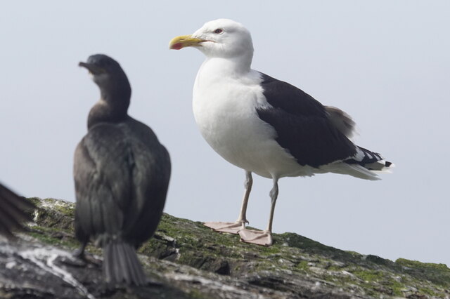
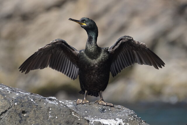
The island is particularly renowned for its seabird colonies, which include puffins, guillemots, razorbills, and kittiwakes. These birds nest on the cliffs and use the surrounding waters to feed on fish and other marine life. Fugla Skerry is part of the wider North Roe and Tingwall Coast Special Protection Area, designated to protect the diverse bird populations found in the area.

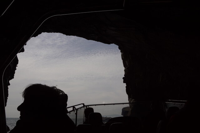
Due to its remote location and lack of human habitation, Fugla Skerry is primarily visited by birdwatchers, researchers, and wildlife enthusiasts. Access to the island is restricted and can only be done by boat. Visitors can enjoy stunning views of the rugged coastline and observe the diverse birdlife from a safe distance.

Fugla Skerry serves as a valuable sanctuary for seabirds and plays a crucial role in the preservation of Shetland's natural heritage.

If you have any feedback on the listing, please let us know in the comments section below.

Fugla Skerry Images

Images are sourced within 2km of 60.109115/-1.0723195 or Grid Reference HU5136. Thanks to Geograph Open Source API. All images are credited.

The Orkneyman's Cave, Bressay Known locally as the Orkneyman's Cave*, this is the Cave of the Bard on the headland of the same name, Bressay, Shetland.

*A popular myth is that this cave was used as a hiding place for a man from Orkney evading a press-gang; although his boat is said to have washed away in a storm, he managed to climb the cliffs onto Bressay and make his escape.
The Orkneyman's Cave, Bressay
Known locally as the Orkneyman's Cave*, this is the Cave of the Bard on the headland of the same name, Bressay, Shetland. *A popular myth is that this cave was used as a hiding place for a man from Orkney evading a press-gang; although his boat is said to have washed away in a storm, he managed to climb the cliffs onto Bressay and make his escape.
Bard Head, Bressay Taken from about 3.5 km to the west, from the Aberdeen ferry. A full moon is just rising.
Bard Head, Bressay
Taken from about 3.5 km to the west, from the Aberdeen ferry. A full moon is just rising.
The Giant's Leg A sea arch at the end of Bard Head, the most southerly point of Bressay.
The Giant's Leg
A sea arch at the end of Bard Head, the most southerly point of Bressay.
Fulmars wheel in the up-draught on the cliffs of Bressay
Bard Head Taken from the Marco Polo cruise ship on the way out of Lerwick.
Bard Head
Taken from the Marco Polo cruise ship on the way out of Lerwick.
Bard Head View from the Lerwick to Aberdeen Ferry.
Bard Head
View from the Lerwick to Aberdeen Ferry.
Mills of the Ord, Bressay, from the sea
Coastline at the Orkneyman's Cave, the Bard, Bressay
Orkneyman's Cave, the Bard, Bressay Although labelled as the Cave of the Bard on OS maps, this is the name by which everyone in Shetland knows it.
Orkneyman's Cave, the Bard, Bressay
Although labelled as the Cave of the Bard on OS maps, this is the name by which everyone in Shetland knows it.
The Giant's Leg, The Bard, Bressay
Bard Head, Bressay, from the sea
In the Orkneyman's Cave, Bard Head, Bressay, looking out
Orkneyman's Cave, Bard Head, Bressay Labelled as Cave of the Bard on the map, but no-one locally uses that name.
Orkneyman's Cave, Bard Head, Bressay
Labelled as Cave of the Bard on the map, but no-one locally uses that name.
Mills of the Ord, Bressay, from the sea
Guillemot (Uria aalge), Bard Head, Bressay
Kittiwake (Rissa tridactyla), Bard Head, Bressay
Great Black-backed Gull (Larus marinus), Bard Head, Bressay
Shag (Gulusus aristotelis), Bard Head, Bressay
Show me another place!

Fugla Skerry is located at Grid Ref: HU5136 (Lat: 60.109115, Lng: -1.0723195)

Unitary Authority: Shetland Islands

Police Authority: Highlands and Islands

What 3 Words

///ripe.sticks.vandalism. Near Lerwick, Shetland Islands

Related Wikis

Bressay transmitting station

Bressay transmitting station is a broadcasting transmission facility for the Shetland Islands, located on the isle of Bressay, owned and operated by Arqiva...

Holm of Noss

The Holm of Noss or Cradle Holm is an uninhabited islet of the Shetland Islands. It is about 48m at its highest point. == Geography and geology == It is...

Bressay

Bressay is a populated island in the Shetland archipelago of Scotland. == Geography and geology == Bressay lies due south of Whalsay, west of the Isle...

Isle of Noss

The Isle of Noss or Noss (Scots: Noss) is a small, previously inhabited island in Shetland, Scotland. Noss is separated from the island of Bressay by the...

Nearby Amenities

Located within 500m of 60.109115,-1.0723195
Source: bing
Lat/Long: 60.1049946/-1.0722673
Source: bing
Lat/Long: 60.1081888/-1.0756136
Source: bing
Lat/Long: 60.111891/-1.0706079
Source: bing
Lat/Long: 60.104637/-1.0729007
Source: bing
Lat/Long: 60.1047302/-1.0729246
Source: bing
Lat/Long: 60.1047481/-1.0728768
Source: bing
Lat/Long: 60.1048135/-1.0728808
Source: bing
Lat/Long: 60.1048294/-1.072662
Source: bing
Lat/Long: 60.1048294/-1.0727853
Source: bing
Lat/Long: 60.1048532/-1.0725824
Source: bing
Lat/Long: 60.1049404/-1.0724909
Source: bing
Lat/Long: 60.1050674/-1.0724272
Source: bing
Lat/Long: 60.1051408/-1.0724351
Source: bing
Lat/Long: 60.1052221/-1.0725545
Source: bing
Lat/Long: 60.1053549/-1.0726182
Source: bing
Lat/Long: 60.1054025/-1.0726699
Source: bing
Lat/Long: 60.1054323/-1.0727614
Source: bing
Lat/Long: 60.1055017/-1.0727933
Source: bing
Lat/Long: 60.1055017/-1.072845
Source: bing
Lat/Long: 60.1056028/-1.0729445
Source: bing
Lat/Long: 60.105771/-1.0730047
Source: bing
Lat/Long: 60.1058036/-1.0730999
Source: bing
Lat/Long: 60.1058493/-1.0732825
Source: bing
Lat/Long: 60.1058535/-1.0734176
Source: bing
Lat/Long: 60.1058661/-1.0733979
Source: bing
Lat/Long: 60.1059537/-1.0737996
Source: bing
Lat/Long: 60.1059553/-1.0738424
Source: bing
Lat/Long: 60.105994/-1.0737648
Source: bing
Lat/Long: 60.1060019/-1.0737867
Source: bing
Lat/Long: 60.1060128/-1.0738961
Source: bing
Lat/Long: 60.1061219/-1.0739439
Source: bing
Lat/Long: 60.1061368/-1.0738384
Source: bing
Lat/Long: 60.1061834/-1.0738484
Source: bing
Lat/Long: 60.1061933/-1.073926
Source: bing
Lat/Long: 60.1062458/-1.0739359
Source: bing
Lat/Long: 60.1062815/-1.0739936
Source: bing
Lat/Long: 60.1063678/-1.0740195
Source: bing
Lat/Long: 60.1064035/-1.0740453
Source: bing
Lat/Long: 60.1065731/-1.074091
Source: bing
Lat/Long: 60.1066224/-1.0740057
Source: bing
Lat/Long: 60.1066238/-1.0741774
Source: bing
Lat/Long: 60.1066392/-1.0740789
Source: bing
Lat/Long: 60.1066827/-1.0741914
Source: bing
Lat/Long: 60.1067135/-1.0741464
Source: bing
Lat/Long: 60.1067766/-1.0741127
Source: bing
Lat/Long: 60.1070571/-1.074273
Source: bing
Lat/Long: 60.1070599/-1.0743884
Source: bing
Lat/Long: 60.1071272/-1.0744306
Source: bing
Lat/Long: 60.1071987/-1.0743828
Source: bing
Lat/Long: 60.1072548/-1.0742421
Source: bing
Lat/Long: 60.1076991/-1.0744763
Source: bing
Lat/Long: 60.1078003/-1.0747457
Source: bing
Lat/Long: 60.1079139/-1.0749568
Source: bing
Lat/Long: 60.1079798/-1.0751847
Source: bing
Lat/Long: 60.1080611/-1.0752972
Source: bing
Lat/Long: 60.1081656/-1.0737965
Source: bing
Lat/Long: 60.108255/-1.0757643
Source: bing
Lat/Long: 60.108283/-1.0738397
Source: bing
Lat/Long: 60.1084008/-1.0755054
Source: bing
Lat/Long: 60.1084064/-1.0742449
Source: bing
Lat/Long: 60.1084513/-1.0746951
Source: bing
Lat/Long: 60.1084793/-1.0752803
Source: bing
Lat/Long: 60.1085133/-1.0743315
Source: bing
Lat/Long: 60.1085747/-1.0747739
Source: bing
Lat/Long: 60.1086455/-1.0741865
Source: bing
Lat/Long: 60.1086719/-1.0739655
Source: bing
Lat/Long: 60.1086742/-1.0751506
Source: bing
Lat/Long: 60.1093342/-1.0744748
Source: bing
Lat/Long: 60.1095881/-1.0746737
Source: bing
Lat/Long: 60.1099384/-1.0729609
Source: bing
Lat/Long: 60.1099909/-1.0739622
Source: bing
Lat/Long: 60.11006/-1.073106
Source: bing
Lat/Long: 60.1101248/-1.0747993
Source: bing
Lat/Long: 60.1105641/-1.0730532
Source: bing
Lat/Long: 60.111083/-1.0725751
Source: bing
Lat/Long: 60.1113472/-1.0725714
Source: bing
Lat/Long: 60.1114242/-1.0726126
Source: bing
Lat/Long: 60.1117216/-1.0724693
Source: bing
Lat/Long: 60.1117335/-1.0726842
Source: bing
Lat/Long: 60.1120046/-1.072364
Source: bing
Lat/Long: 60.1120111/-1.0724773
Source: bing
Lat/Long: 60.1121235/-1.0712802
Source: bing
Lat/Long: 60.1123235/-1.0700798
Source: bing
Lat/Long: 60.110009/-1.0741798
Source: bing
Lat/Long: 60.1100371/-1.0743655
Source: bing
Lat/Long: 60.1100735/-1.0743486
Source: bing
Lat/Long: 60.1100876/-1.0746244
Source: bing
Lat/Long: 60.110124/-1.0746863
Source: bing
Lat/Long: 60.1101549/-1.0745737
Source: bing
Lat/Long: 60.1104185/-1.0730375
Source: bing
Lat/Long: 60.110525/-1.0729868
Source: bing
Lat/Long: 60.1109485/-1.0727055
Source: bing
Lat/Long: 60.1110775/-1.072683
Source: bing
Lat/Long: 60.1118009/-1.0711354
Source: bing
Lat/Long: 60.1118262/-1.0710848
Source: bing
Lat/Long: 60.1118318/-1.0708428
Source: bing
Lat/Long: 60.1118374/-1.0709272
Source: bing
Lat/Long: 60.1118374/-1.071006
Source: bing
Lat/Long: 60.1118374/-1.0712705
Source: bing
Lat/Long: 60.111843/-1.0706853
Source: bing
Lat/Long: 60.1118486/-1.0715744
Source: bing
Lat/Long: 60.1118514/-1.0717207
Source: bing
Lat/Long: 60.1118542/-1.0708597
Source: bing
Lat/Long: 60.1118626/-1.0707584
Source: bing
Lat/Long: 60.1118626/-1.0710116
Source: bing
Lat/Long: 60.111871/-1.0720246
Source: bing
Lat/Long: 60.1118879/-1.0707472
Source: bing
Lat/Long: 60.1118963/-1.07167
Source: bing
Lat/Long: 60.1119019/-1.071051
Source: bing
Lat/Long: 60.1119299/-1.0720921
Source: bing
Lat/Long: 60.1119495/-1.0710342
Source: bing
Lat/Long: 60.111958/-1.0711523
Source: bing
Lat/Long: 60.111958/-1.0712255
Source: bing
Lat/Long: 60.1119804/-1.072244
Source: bing
Lat/Long: 60.1119832/-1.0710904
Source: bing
Lat/Long: 60.1119969/-1.0712198
Source: bing
Lat/Long: 60.1120173/-1.0713159
Source: bing
Lat/Long: 60.1121229/-1.0711372
Source: bing
Lat/Long: 60.1121429/-1.0711349
Source: bing
Lat/Long: 60.1121606/-1.0711551
Source: bing
Lat/Long: 60.1122052/-1.0708805
Source: bing
Lat/Long: 60.1122054/-1.071118
Source: bing
Lat/Long: 60.1122062/-1.0710636
Source: bing
Lat/Long: 60.1122121/-1.0710725
Source: bing
Lat/Long: 60.1122379/-1.070598
Source: bing
Lat/Long: 60.1122389/-1.0708984
Source: bing
Lat/Long: 60.1122597/-1.0705821
Source: bing
Lat/Long: 60.1122617/-1.0705483
Source: bing
Lat/Long: 60.1123063/-1.0704588
Source: bing
Lat/Long: 60.1123103/-1.0705463
Source: bing
Lat/Long: 60.1123301/-1.0704488
Source: bing
Lat/Long: 60.112422/-1.0701239
Source: bing
Lat/Long: 60.1124739/-1.0700705
Source: bing
Lat/Long: 60.112523/-1.0700874
Source: bing
Lat/Long: 60.1125286/-1.0700508
Source: bing
Lat/Long: 60.112558/-1.0698932
Source: bing
Lat/Long: 60.1125594/-1.070062
Source: bing
Lat/Long: 60.1126141/-1.0699073
Source: bing
Lat/Long: 60.1126239/-1.0697497
Source: bing
Lat/Long: 60.1127111/-1.0697197
Source: bing
Lat/Long: 60.1127643/-1.0697422
Source: bing
Lat/Long: 60.1127784/-1.0696634
Source: bing
Lat/Long: 60.1129938/-1.0692792
Source: bing
Lat/Long: 60.1130896/-1.0692526
Source: bing
Lat/Long: 60.1132018/-1.0692751
The data included in this document is from www.openstreetmap.org. The data is made available under ODbL.

Have you been to Fugla Skerry?

Leave your review of Fugla Skerry below (or comments, questions and feedback).