St Anthony Rock

Island in Hampshire

England

St Anthony Rock

The Old Battery
The Old Battery Credit: Barry Shimmon

St Anthony Rock is a small island located off the coast of Hampshire, England. It is situated in the English Channel, approximately 1.5 miles south of the town of Lymington. This rocky outcrop measures about 1.5 acres in size and is accessible only by boat.

The island is known for its rugged beauty and is a popular destination for nature enthusiasts and bird watchers. It is home to a variety of seabirds, including cormorants, gulls, and oystercatchers. The surrounding waters are also teeming with marine life, making it a great spot for snorkeling and diving.

At low tide, it is possible to walk across a causeway to reach the island, but caution is advised as the path can become submerged during high tide. The island is predominantly rocky, with little vegetation, but it offers stunning panoramic views of the coastline and the Isle of Wight.

St Anthony Rock has a rich history, dating back to the 16th century when it was used as a defensive fortification against French invaders. Over the years, it has also served as a lighthouse and a navigational aid for ships entering the Solent. Today, the remains of the lighthouse still stand, adding to the island's charm and historical significance.

Visitors to St Anthony Rock are advised to check the tides and weather conditions before planning a trip, as the island can be inaccessible during high seas. Nonetheless, it remains a hidden gem for those seeking a peaceful retreat or a glimpse into Hampshire's maritime past.

If you have any feedback on the listing, please let us know in the comments section below.

St Anthony Rock Images

Images are sourced within 2km of 50.660252/-1.5815428 or Grid Reference SZ2984. Thanks to Geograph Open Source API. All images are credited.

The Old Battery
The Old Battery
Isle of Wight from Mudeford Spit The grass dunes on Mudeford spit frame the tip of the Isle of Wight, including The Needles. A couple of holidaymakers are just visible bottom left.
Isle of Wight from Mudeford Spit
The grass dunes on Mudeford spit frame the tip of the Isle of Wight, including The Needles. A couple of holidaymakers are just visible bottom left.
The Guns One of the two guns at The Old Battery by The Needles
The Guns
One of the two guns at The Old Battery by The Needles
The Needles Viewed from the Old Battery
The Needles
Viewed from the Old Battery
The Needles Isle of Wight
The Needles from the Old Battery
Alum Bay in 1988 As seen from the Old Battery. Hatherwood Point is on the right of the frame.
Alum Bay in 1988
As seen from the Old Battery. Hatherwood Point is on the right of the frame.
The Needles 1984
The Needles 1984
The Needles and the Old Battery A view of the Needles from the coastal path.
The Needles and the Old Battery
A view of the Needles from the coastal path.
South Wight : The Solent Looking towards the gap between Hampshire and the Isle of Wight which leads into the Solent.
South Wight : The Solent
Looking towards the gap between Hampshire and the Isle of Wight which leads into the Solent.
South Wight : Beacon & Bournemouth Looking towards a red beacon in the sea with the Bournemouth coastline behind it.
South Wight : Beacon & Bournemouth
Looking towards a red beacon in the sea with the Bournemouth coastline behind it.
South Wight : Yellow Beacon A yellow beacon marking a site of a shipwreck just off of the Needles.
South Wight : Yellow Beacon
A yellow beacon marking a site of a shipwreck just off of the Needles.
South Wight : The Needles & Lighthouse The Needles were featured on the 2005 TV programme Seven Natural Wonders as one of the wonders of Southern England.
South Wight : The Needles & Lighthouse
The Needles were featured on the 2005 TV programme Seven Natural Wonders as one of the wonders of Southern England.
South Wight : The Needles & Cliffs Looking towards the cliffs from a boat travelling along the Needles.
South Wight : The Needles & Cliffs
Looking towards the cliffs from a boat travelling along the Needles.
South Wight : The Needles & Former Pillar The formation takes its name from the former fourth needle-shaped pillar called Lot's Wife that used to stand in its midst until it collapsed in a storm in 1764. The remaining rocks are all short and squat and not at all needle-like, but the name has stuck.
South Wight : The Needles & Former Pillar
The formation takes its name from the former fourth needle-shaped pillar called Lot's Wife that used to stand in its midst until it collapsed in a storm in 1764. The remaining rocks are all short and squat and not at all needle-like, but the name has stuck.
South Wight : Needles Lighthouse 1859 by James Walker, consultant engineer to Trinity House, replacing an earlier lighthouse which stood on the cliff top. Built of granite masonry. 33.25 metres high of uniform diameter with an unevenly stepped base. Although the tower has no taper the walls vary from 1.07 metres in thickness at the bottom to 0.61 metres at the top. Battlemented parapet.
South Wight : Needles Lighthouse
1859 by James Walker, consultant engineer to Trinity House, replacing an earlier lighthouse which stood on the cliff top. Built of granite masonry. 33.25 metres high of uniform diameter with an unevenly stepped base. Although the tower has no taper the walls vary from 1.07 metres in thickness at the bottom to 0.61 metres at the top. Battlemented parapet.
South Wight : The Needles & Cormorant A cormorant on the top of one of the Needles rocks beside a shag.
South Wight : The Needles & Cormorant
A cormorant on the top of one of the Needles rocks beside a shag.
South Wight : The Needles Looking towards the edge of the Needles with the lighthouse at the point.
South Wight : The Needles
Looking towards the edge of the Needles with the lighthouse at the point.
Show me another place!

St Anthony Rock is located at Grid Ref: SZ2984 (Lat: 50.660252, Lng: -1.5815428)

Unitary Authority: Isle of Wight

Police Authority: Hampshire

What 3 Words

///revised.tragedy.noun. Near Totland, Isle of Wight

Related Wikis

Scratchell's Bay

Scratchell's Bay is a bay on the south west coast of the Isle of Wight, England just to the south east of The Needles. It faces roughly south towards the...

The Needles Batteries

The Needles Batteries are two military batteries built above the Needles stacks to guard the West end of the Solent. The field of fire was from approximately...

High Down Rocket Test Site

The High Down Rocket Test Site is a former Rocket Testing facility on High Down near The Needles. The remains of the High Down Test Site are a rare example...

HMS Assurance (1747)

HMS Assurance was a 44-gun fifth rate frigate of the Royal Navy, launched in 1747. She was wrecked off The Needles near the Isle of Wight, England in 1753...
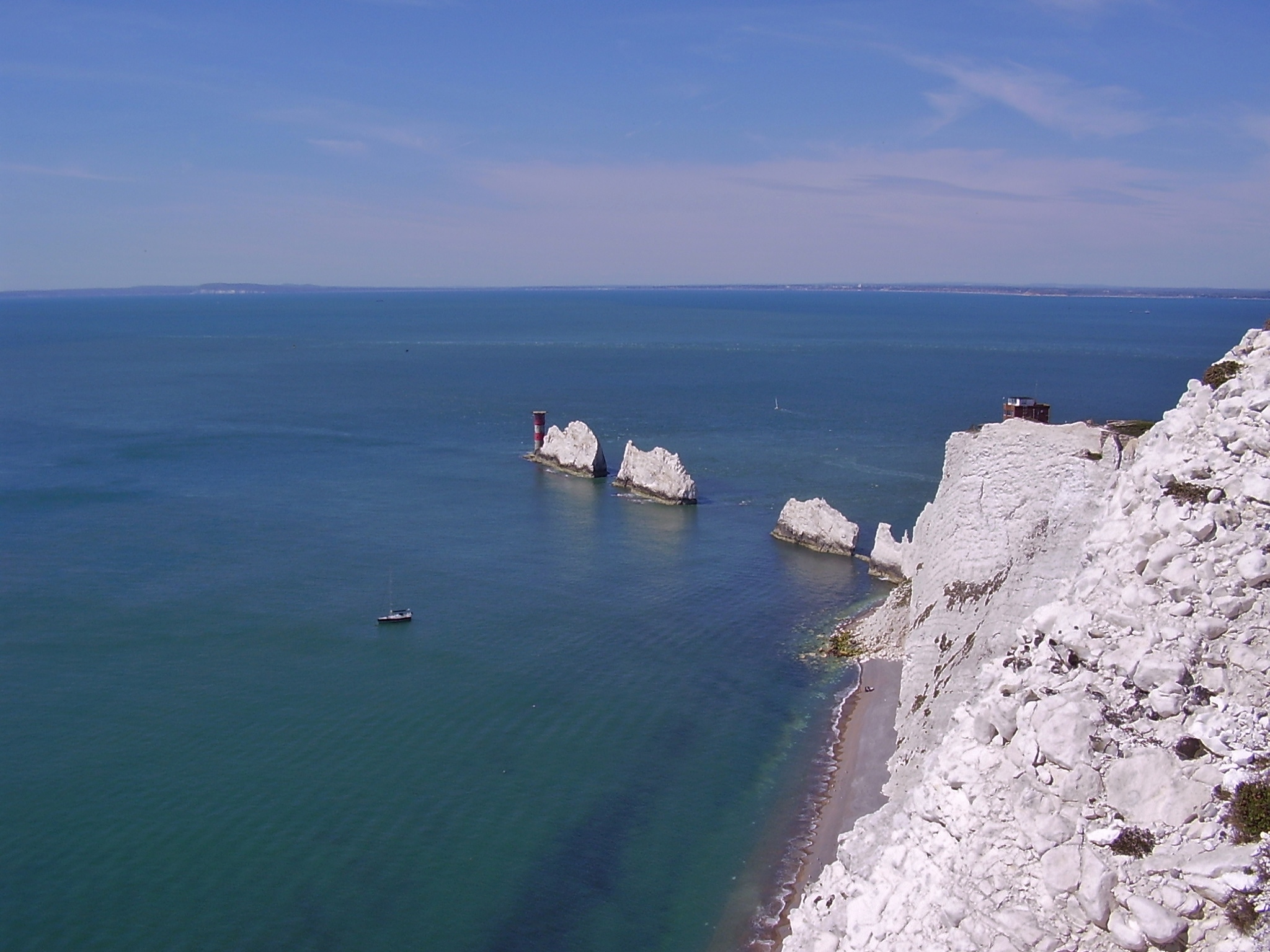
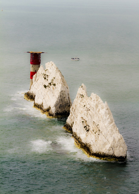
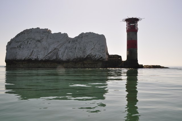
The Needles

The Needles are a row of three stacks of chalk that rise about 30 metres (98 ft) out of the sea off the western extremity of the Isle of Wight in the English...
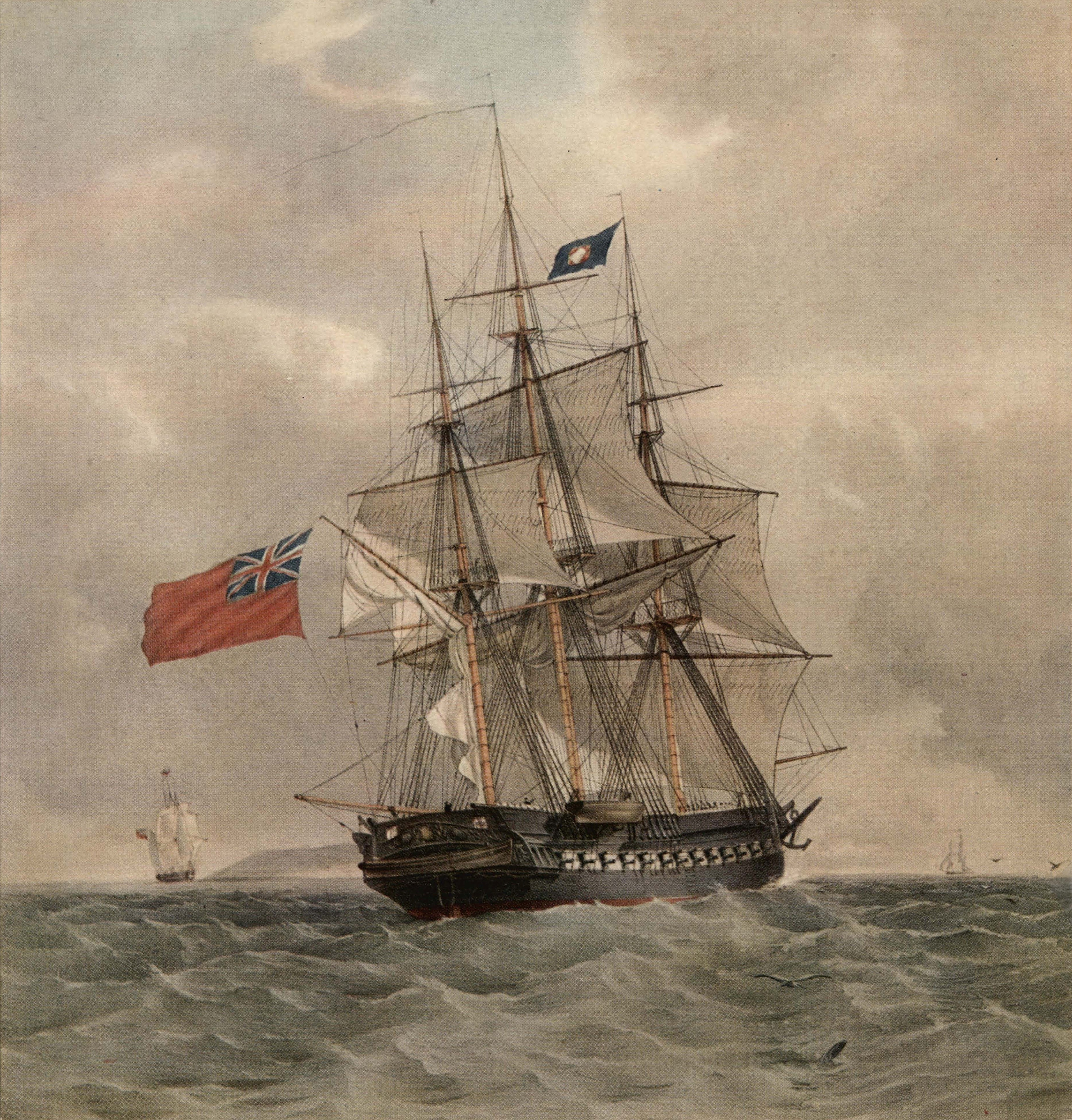
HMS Pomone (1805)

HMS Pomone was a 38-gun Leda-class fifth rate of the Royal Navy launched in 1805. She saw action during the Napoleonic Wars, primarily in the Mediterranean...
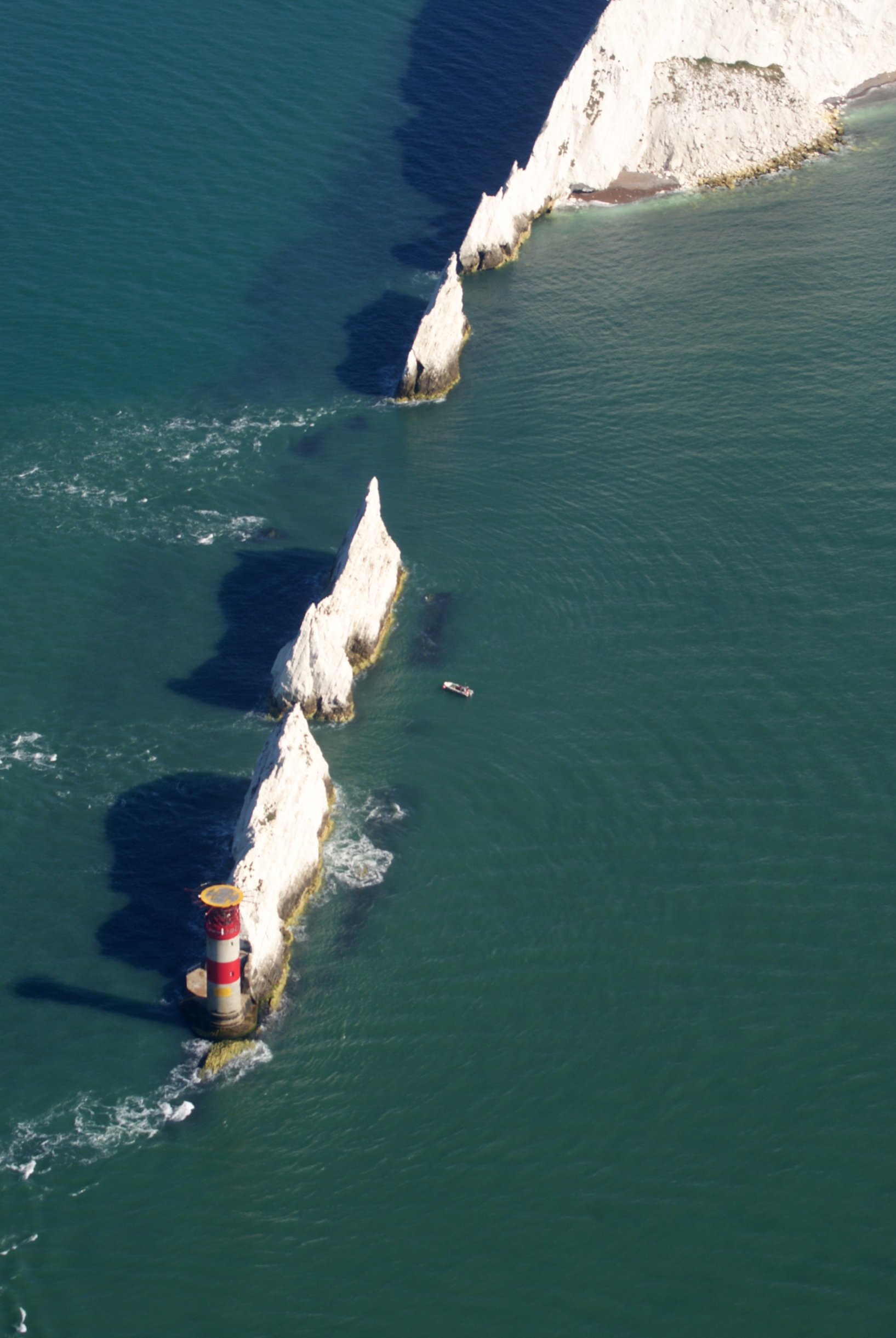
Needles Lighthouse

The Needles Lighthouse is an active 19th century lighthouse on the outermost of the chalk rocks at The Needles on the Isle of Wight in the United Kingdom...

Alum Bay

Alum Bay is a bay near the westernmost point of the Isle of Wight, England, within close sight of the Needles rock formation. Of geological interest and...

Nearby Amenities

Located within 500m of 50.660252,-1.5815428
Man Made: tower
Operator: Airwave
Operator Wikidata: Q4699058
Tower: mast
Tower Type: communication
Lat/Long: 50.6613573/-1.576564
Needles Viewpoint
Direction: 280
Tourism: viewpoint
Lat/Long: 50.661443/-1.5791037
Source: Bing
Lat/Long: 50.6623933/-1.5774723
Source: Bing
Lat/Long: 50.6619017/-1.5785504
Source: Bing
Lat/Long: 50.662473/-1.5771849
Source: Bing
Lat/Long: 50.6604442/-1.5747473
Source: Bing
Lat/Long: 50.6603119/-1.5765565
Source: Bing
Lat/Long: 50.6601207/-1.5790124
Source: Bing
Lat/Long: 50.6601918/-1.5794653
Source: Bing
Lat/Long: 50.6612022/-1.5751384
Old Battery Museum
Ele: 77
Fee: yes
Operator: National Trust
Tourism: museum
Wikidata: Q26514877
Lat/Long: 50.662862/-1.5827962
Source: Landsat and local knowledge
Lat/Long: 50.6629919/-1.5869511
Source: Landsat and local knowledge
Lat/Long: 50.6630786/-1.5867306
Source: Bing
Lat/Long: 50.6604895/-1.5793315
Scratchells Bay
Natural: bay
Source: npe
Lat/Long: 50.6609718/-1.5829278
Bus Stop
Old Battery
Bench: no
Bin: no
Bus: yes
Contact Website: https://www.islandbuses.info/stops/230000013210
Lit: no
Naptan AtcoCode: 230000013210
Naptan Bearing: NE
Naptan CommonName: Needles Old Battery
Naptan Indicator: Adj
Naptan Landmark: Old Battery
Naptan NaptanCode: iowjwgt
Naptan Street: Private Road
Public Transport: platform
Shelter: no
Tactile Paving: no
Lat/Long: 50.6631028/-1.5795638
Bus Stop
Needles Battery
Bus: yes
Contact Website: https://www.islandbuses.info/stops/2300207
Naptan AtcoCode: 2300207
Naptan Bearing: NE
Naptan BusStopType: CUS
Naptan CommonName: Needles
Naptan Indicator: adjacent
Naptan Landmark: New Battery
Naptan NaptanCode: iowmgdp
Naptan Street: Private Road
Naptan Verified: no
Public Transport: platform
Shelter: no
Lat/Long: 50.6621632/-1.5782794
Source: Bing
Lat/Long: 50.6602939/-1.5762567
Source: Bing
Lat/Long: 50.6611025/-1.5790643
Historic: monument
Lat/Long: 50.6623304/-1.5778802
Needles New Battery
Fee: yes
Layer: -1
Tourism: museum
Wikidata: Q26504483
Lat/Long: 50.6622246/-1.5780434
Cafe
Tearooms
Addr City: Totland
Addr Country: GB
Addr Postcode: PO39 0JH
Addr Street: Needles Battery Road
Fhrs Id: 540752
Source Addr: FHRS Open Data
Lat/Long: 50.6627718/-1.5834855
New Battery Kiosk
Layer: -1
Shop: kiosk
Lat/Long: 50.6622913/-1.577903
Bench
Lat/Long: 50.6626983/-1.5818937
Bench
Backrest: no
Mapillary: 1021974768621486
Survey Date: 2019-01-14
Lat/Long: 50.6621113/-1.5784812
Bench
Backrest: no
Lat/Long: 50.6625257/-1.5808441
Bench
Backrest: no
Lat/Long: 50.6625761/-1.5769485
Bench
Backrest: yes
Lat/Long: 50.661998/-1.5783405
Information: board
Tourism: information
Lat/Long: 50.6612512/-1.5760897
Defibrillator
Access: permissive
Defibrillator Location: On concrete wall near bus stop at Coastwatch Station
Emergency: defibrillator
Emergency Phone: 999
Indoor: no
Ref GB The Circuit: 707D48F8-1FC0-4769-B7EB-AD3B009DBB71
Lat/Long: 50.6620545/-1.5783499
High Down Rocket Test Site
Historic: ruins
Wikidata: Q18349428
Wikipedia: en:High Down Rocket Test Site
Lat/Long: 50.6613132/-1.5782432
Seamark Rock Water Level: awash
Seamark Type: rock
Lat/Long: 50.6621986/-1.5865669
Seamark Rock Water Level: awash
Seamark Type: rock
Lat/Long: 50.6620235/-1.586194
St. Anthony Rock
Seamark Rock Water Level: covers
Seamark Type: rock
Lat/Long: 50.6602858/-1.5816021
Irex Rock
Seamark Rock Water Level: awash
Seamark Type: rock
Lat/Long: 50.659837/-1.5839571
Alchemist
Seamark Type: wreck
Seamark Wreck Category: non-dangerous
Seamark Wreck Water Level: submerged
Lat/Long: 50.6588508/-1.5854967
Seamark Rock Water Level: awash
Seamark Type: rock
Lat/Long: 50.6636829/-1.58584
Turning Circle
Lat/Long: 50.6621047/-1.5781985
Bench
Backrest: no
Lat/Long: 50.6623691/-1.578879
Hiking: yes
Information: guidepost
Tourism: information
Lat/Long: 50.662628/-1.576349
Leisure: picnic_table
Lat/Long: 50.6628018/-1.5832389
Leisure: picnic_table
Lat/Long: 50.6628103/-1.5831584
Leisure: picnic_table
Lat/Long: 50.6628655/-1.583192
Leisure: picnic_table
Lat/Long: 50.6628566/-1.5832704
Needles Old Battery
Historic: castle
Operator: National Trust
Lat/Long: 50.6628694/-1.5830076
Historic: cannon
Lat/Long: 50.6629854/-1.5832336
Historic: cannon
Lat/Long: 50.6629561/-1.583371
Irex
Operator: National Trust
Operator Wikidata: Q333515
Tourism: chalet
Website: https://www.nationaltrust.org.uk/holidays/isle-of-wight/irex
Lat/Long: 50.6621929/-1.5761249
Varvassi
Operator: National Trust
Operator Wikidata: Q333515
Tourism: chalet
Website: https://www.nationaltrust.org.uk/holidays/isle-of-wight/varvassi
Lat/Long: 50.6621917/-1.5759613
Pomone
Operator: National Trust
Operator Wikidata: Q333515
Tourism: chalet
Website: https://www.nationaltrust.org.uk/holidays/isle-of-wight/pomone
Lat/Long: 50.6621942/-1.5762888
Bench
Backrest: yes
Material: wood
Lat/Long: 50.6618854/-1.5779228
Entrance: yes
Lat/Long: 50.662206/-1.578086
Entrance: yes
Lat/Long: 50.6622995/-1.5778798
Man Made: tower
Tower: mast
Tower Type: communication
Lat/Long: 50.6619427/-1.5788072
The data included in this document is from www.openstreetmap.org. The data is made available under ODbL.

Have you been to St Anthony Rock?

Leave your review of St Anthony Rock below (or comments, questions and feedback).