Barwick

Settlement in Devon West Devon

England

Barwick

Old circular AA sign on the former B3217 in Monkokehampton Old AA Sign located on the wall of an old workshop, now a cottage called The Old Forge, on the east side of the former B3217 in Monkokehampton, 8 miles north of Okehampton. Monkokehampton parish.

This is the Circular, village name on black band, no Motor Union symbol or name type, dating from 1923, showing distances Okehampton 7½ Iddesleigh 2¼ London 196. Removed some time between July 2014 and August 2022.

There were five series of AA signs, mostly dating from 1923 and made by Francis & Co / Franco in Deptford, London. The village name and distance to London or Dublin were normally displayed.

See also <span class="nowrap"><a title="https://www.flickr.com/photos/livesurfcams/14394800250" rel="nofollow ugc noopener" href="https://www.flickr.com/photos/livesurfcams/14394800250">Link</a><img style="margin-left:2px;" alt="External link" title="External link - shift click to open in new window" src="https://s1.geograph.org.uk/img/external.png" width="10" height="10"/></span> , <span class="nowrap"><a title="https://www.flickr.com/photos/bumbishop/5656595" rel="nofollow ugc noopener" href="https://www.flickr.com/photos/bumbishop/5656595">Link</a><img style="margin-left:2px;" alt="External link" title="External link - shift click to open in new window" src="https://s1.geograph.org.uk/img/external.png" width="10" height="10"/></span> and <span class="nowrap"><a title="https://www.flickr.com/photos/bridgemarkertim/3966823734" rel="nofollow ugc noopener" href="https://www.flickr.com/photos/bridgemarkertim/3966823734">Link</a><img style="margin-left:2px;" alt="External link" title="External link - shift click to open in new window" src="https://s1.geograph.org.uk/img/external.png" width="10" height="10"/></span>.

Milestone Society National ID: DV-MONKO
Old circular AA sign on the former B3217 in Monkokehampton Credit: A Rosevear

Barwick is a small village located in the county of Devon, England. Situated in the East Devon district, it is nestled amidst the picturesque countryside, offering a tranquil and idyllic setting. The village is situated approximately 10 miles northeast of the city of Exeter.

Barwick is known for its rural charm and close-knit community. It is a quintessentially English village with quaint thatched cottages, lush green fields, and meandering country lanes. The village is surrounded by rolling hills and farmland, providing stunning views of the countryside.

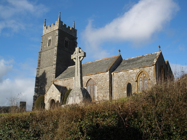
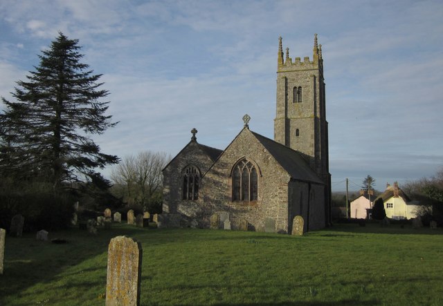
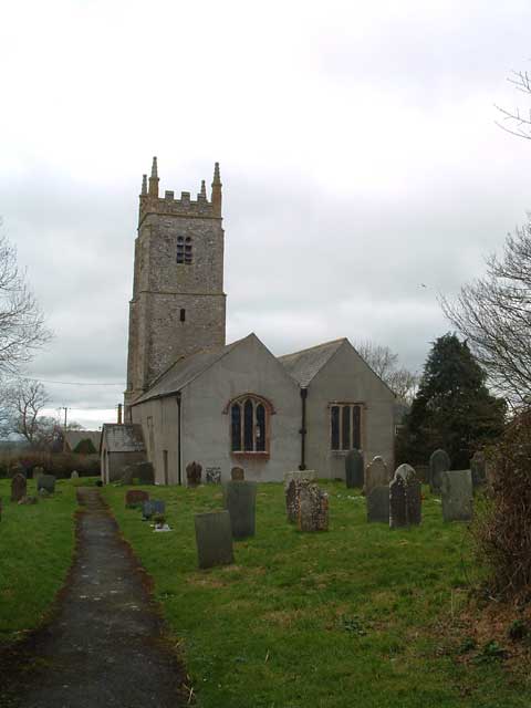
Despite its small size, Barwick has a rich history dating back centuries. The village features a Grade II listed church, St. Mary's, which dates back to the 12th century. The church is a focal point for the community and offers a glimpse into the village's past.

Agriculture plays a significant role in the local economy, with farming being a predominant occupation. The surrounding farmland is used for pasture, arable crops, and dairy farming. The village also benefits from its proximity to Exeter, which provides employment opportunities and access to amenities for the residents.

Barwick offers a peaceful and serene environment, making it an ideal place for those seeking a slower pace of life away from the hustle and bustle of larger towns and cities. The village is well-connected to neighboring areas via road networks, allowing for easy travel to nearby attractions and amenities.

In summary, Barwick is a charming village in Devon, boasting a rich history, stunning countryside views, and a close-knit community. It offers a peaceful and idyllic setting for those looking to escape the urban lifestyle.

If you have any feedback on the listing, please let us know in the comments section below.

Barwick Images

Images are sourced within 2km of 50.845293/-4.004157 or Grid Reference SS5907. Thanks to Geograph Open Source API. All images are credited.

Old circular AA sign on the former B3217 in Monkokehampton Old AA Sign located on the wall of an old workshop, now a cottage called The Old Forge, on the east side of the former B3217 in Monkokehampton, 8 miles north of Okehampton. Monkokehampton parish.

This is the Circular, village name on black band, no Motor Union symbol or name type, dating from 1923, showing distances Okehampton 7½ Iddesleigh 2¼ London 196. Removed some time between July 2014 and August 2022.

There were five series of AA signs, mostly dating from 1923 and made by Francis & Co / Franco in Deptford, London. The village name and distance to London or Dublin were normally displayed.

See also <span class="nowrap"><a title="https://www.flickr.com/photos/livesurfcams/14394800250" rel="nofollow ugc noopener" href="https://www.flickr.com/photos/livesurfcams/14394800250">Link</a><img style="margin-left:2px;" alt="External link" title="External link - shift click to open in new window" src="https://s1.geograph.org.uk/img/external.png" width="10" height="10"/></span> , <span class="nowrap"><a title="https://www.flickr.com/photos/bumbishop/5656595" rel="nofollow ugc noopener" href="https://www.flickr.com/photos/bumbishop/5656595">Link</a><img style="margin-left:2px;" alt="External link" title="External link - shift click to open in new window" src="https://s1.geograph.org.uk/img/external.png" width="10" height="10"/></span> and <span class="nowrap"><a title="https://www.flickr.com/photos/bridgemarkertim/3966823734" rel="nofollow ugc noopener" href="https://www.flickr.com/photos/bridgemarkertim/3966823734">Link</a><img style="margin-left:2px;" alt="External link" title="External link - shift click to open in new window" src="https://s1.geograph.org.uk/img/external.png" width="10" height="10"/></span>.

Milestone Society National ID: DV-MONKO
Old circular AA sign on the former B3217 in Monkokehampton
Old AA Sign located on the wall of an old workshop, now a cottage called The Old Forge, on the east side of the former B3217 in Monkokehampton, 8 miles north of Okehampton. Monkokehampton parish. This is the Circular, village name on black band, no Motor Union symbol or name type, dating from 1923, showing distances Okehampton 7½ Iddesleigh 2¼ London 196. Removed some time between July 2014 and August 2022. There were five series of AA signs, mostly dating from 1923 and made by Francis & Co / Franco in Deptford, London. The village name and distance to London or Dublin were normally displayed. See also LinkExternal link , LinkExternal link and LinkExternal link. Milestone Society National ID: DV-MONKO
Monkokehampton Mill The last working water-powered corn mill in Devon, heritage and preserved mills aside. Built in the late 19th century, it stands by a leat from the Okement and was originally powered by two small overshot waterwheels. One survives in working order today.
Monkokehampton Mill
The last working water-powered corn mill in Devon, heritage and preserved mills aside. Built in the late 19th century, it stands by a leat from the Okement and was originally powered by two small overshot waterwheels. One survives in working order today.
Broadwoodkelly: south to Dartmoor Farmland and woodland seen from the Monkokehampton-Winkleigh road, near Mount Pleasant. In the distance the Dartmoor range. The rounded height on the left is Cosdon Hill, spot height 550m
Broadwoodkelly: south to Dartmoor
Farmland and woodland seen from the Monkokehampton-Winkleigh road, near Mount Pleasant. In the distance the Dartmoor range. The rounded height on the left is Cosdon Hill, spot height 550m
Iddesleigh Waste Water Treatment Works A small sewage plant beside the B3217 at Pixton Cross. The view behind is down the shallow valley followed briefly by <a href="https://www.geograph.org.uk/photo/465258">SS5607 : Tarka Trail</a>.
Iddesleigh Waste Water Treatment Works
A small sewage plant beside the B3217 at Pixton Cross. The view behind is down the shallow valley followed briefly by SS5607 : Tarka Trail.
Iddesleigh Footpath 10 The footpath just after a footbridge over a little stream, near the start of a very shady stretch climbing to the lane at Pixton.
Iddesleigh Footpath 10
The footpath just after a footbridge over a little stream, near the start of a very shady stretch climbing to the lane at Pixton.
View near Barwick Looking across a shallow valley from a gateway on the lane between Pixton and Barwick. The further part of the view is in SS5908.
View near Barwick
Looking across a shallow valley from a gateway on the lane between Pixton and Barwick. The further part of the view is in SS5908.
Field of barley near Barwick A promising crop in the evening sun, seen from the stile by which Iddesleigh Footpath 3 leaves the lane from Barwick to Loosedon Cross. The small valley ahead on the left can be seen in <a href="https://www.geograph.org.uk/photo/465274">SS5907 : View near Barwick</a>.
Field of barley near Barwick
A promising crop in the evening sun, seen from the stile by which Iddesleigh Footpath 3 leaves the lane from Barwick to Loosedon Cross. The small valley ahead on the left can be seen in SS5907 : View near Barwick.
Road from Pixton Cross The B3217 bends away from the junction with the lane to Pixton; sheep graze in the evening sun in a large field on the right. On the left, about 800 metres away is <a href="https://www.geograph.org.uk/photo/469322">SS5608 : Iddesleigh church</a>.
Road from Pixton Cross
The B3217 bends away from the junction with the lane to Pixton; sheep graze in the evening sun in a large field on the right. On the left, about 800 metres away is SS5608 : Iddesleigh church.
Field by lane to Pixton A lush grassy field next to the lane from Iddesleigh to Pixton. Across the fields and the shallow valley is East Park (in SS5708), on the extreme left.
Field by lane to Pixton
A lush grassy field next to the lane from Iddesleigh to Pixton. Across the fields and the shallow valley is East Park (in SS5708), on the extreme left.
Evening sun at Pixton A view across the field adjacent to <a href="https://www.geograph.org.uk/photo/465267">SS5807 : Iddesleigh Footpath 10</a>, which is to the right. Across the valley on the extreme left is  East Park (in SS5708). Taken from a gateway on the lane at Pixton.
Evening sun at Pixton
A view across the field adjacent to SS5807 : Iddesleigh Footpath 10, which is to the right. Across the valley on the extreme left is East Park (in SS5708). Taken from a gateway on the lane at Pixton.
Pixton A pretty thatched cottage roof peeps over the hedge. Taken from the point where Iddesleigh Footpath 10 leaves the lane between Iddesleigh and Barwick.
Pixton
A pretty thatched cottage roof peeps over the hedge. Taken from the point where Iddesleigh Footpath 10 leaves the lane between Iddesleigh and Barwick.
View near Lane End Cottage Looking across the shallow valley seen in <a href="https://www.geograph.org.uk/photo/469447">SS5807 : Evening sun at Pixton</a> and <a href="https://www.geograph.org.uk/photo/465274">SS5907 : View near Barwick</a>. In the distance, beyond the unnamed wood, is Henacroft (in SY5908).
View near Lane End Cottage
Looking across the shallow valley seen in SS5807 : Evening sun at Pixton and SS5907 : View near Barwick. In the distance, beyond the unnamed wood, is Henacroft (in SY5908).
Fields near Barwick Evening sunlight illuminates a grassy field west of Barwick. Taken from the same place as <a href="https://www.geograph.org.uk/photo/465274">SS5907 : View near Barwick</a>, which looks to the right. The area beyond the brightly-lit field is in SY5908, and the area to the left of wood is in SY5808.
Fields near Barwick
Evening sunlight illuminates a grassy field west of Barwick. Taken from the same place as SS5907 : View near Barwick, which looks to the right. The area beyond the brightly-lit field is in SY5908, and the area to the left of wood is in SY5808.
Looking towards East Wood East Wood is the small coniferous wood in the distance. To the right of the hedges are deciduous woods. Seen from a corner on the lane between Iddesleigh and Loosedon Cross.
Looking towards East Wood
East Wood is the small coniferous wood in the distance. To the right of the hedges are deciduous woods. Seen from a corner on the lane between Iddesleigh and Loosedon Cross.
Pony's Moor Plantation Seen across a field from the farm track to Stafford Beer.
Pony's Moor Plantation
Seen across a field from the farm track to Stafford Beer.
Valley north of Monkokehampton The valley carries a tributary of the River Okement. On the right is Ford's Cleave Wood. Seen from the lane between Monkokehampton and Barwick.
Valley north of Monkokehampton
The valley carries a tributary of the River Okement. On the right is Ford's Cleave Wood. Seen from the lane between Monkokehampton and Barwick.
Lane to Weekmore Cross Late convolvulus is conspicuous in the hedge on the right. The lane connects the B3217 at Waldons Cross with a parallel lane. The almost-detectable remnants of a rainbow are fading above the left-hand tree.
Lane to Weekmore Cross
Late convolvulus is conspicuous in the hedge on the right. The lane connects the B3217 at Waldons Cross with a parallel lane. The almost-detectable remnants of a rainbow are fading above the left-hand tree.
Rainbow near Iddesleigh A rainbow descends into what appears to be a wood but in fact is an amalgamation of three field boundaries all lined with trees. <a href="https://www.geograph.org.uk/photo/469322">SS5608 : Iddesleigh church</a> is in the distance. Taken from the lane between Waldons Cross and Barwick
Rainbow near Iddesleigh
A rainbow descends into what appears to be a wood but in fact is an amalgamation of three field boundaries all lined with trees. SS5608 : Iddesleigh church is in the distance. Taken from the lane between Waldons Cross and Barwick
Show me another place!

Barwick is located at Grid Ref: SS5907 (Lat: 50.845293, Lng: -4.004157)

Administrative County: Devon

District: West Devon

Police Authority: Devon and Cornwall

What 3 Words

///stylist.leathers.guesswork. Near Winkleigh, Devon

Nearby Locations

Barwick

Related Wikis

Monkokehampton

Monkokehampton is a village and civil parish in West Devon, England. The village lies on the River Okement, about 3 miles (4.8 km) east-north-east of Hatherleigh...

Church of St James, Iddesleigh

St James' Church, Iddesleigh, is a church in the small village of Iddesleigh, Devon, England. It dates back to the 13th century, although most of the...

Iddesleigh

Iddesleigh is a village and civil parish in the county of Devon, England. The settlement has ancient origins and is listed in the Domesday Book. The village...

Broadwoodkelly

Broadwoodkelly is a village and civil parish in the West Devon district of Devon, England. According to the 2001 census it had a population of 218. The...

River Okement

The River Okement is a tributary of the River Torridge in Devon, England. It rises at two places in Dartmoor, as the West Okement and the East Okement...

Winkleigh

Winkleigh is a civil parish and small village in Devon, England. It is part of the local government area of Torridge District Council. The population of...

Dowland, Devon

Dowland is a civil parish in Devon, situated near Winkleigh. It is also the name of a hamlet in the parish. == References ==

RAF Winkleigh

Royal Air Force Winkleigh, or more simply RAF Winkleigh, is a former Royal Air Force satellite station located near to Winkleigh, Devon and south of Barnstaple...

Nearby Amenities

Located within 500m of 50.845293,-4.004157
Generator Method: photovoltaic
Generator Output Electricity: yes
Generator Source: solar
Generator Type: solar_photovoltaic_panel
Location: roof
Power: generator
Lat/Long: 50.8474036/-4.0075359
The data included in this document is from www.openstreetmap.org. The data is made available under ODbL.

Have you been to Barwick?

Leave your review of Barwick below (or comments, questions and feedback).